Gunung Ili Lewotolok, Lembata, East Nusa Tenggara, Indonesia, 9 September 2026
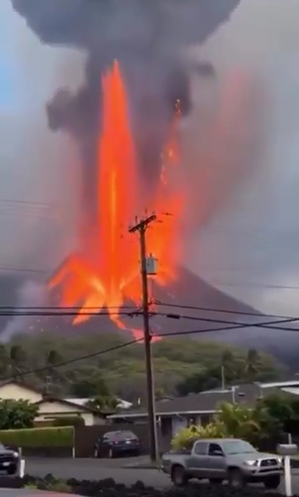
The seismographs on Gunung Ili Lewotolok logged 388 eruption earthquakes on Wednesday, roughly one every four minutes, while the observers watching the summit from their post at Laranwutun saw mostly white vapour. Two eruptions early in the morning, at 05:03 and 05:56 local time, threw up grey ash high enough to measure, as much as 600 metres above the 1,423-metre summit, and the wind carried it northwest. Through the rest of the day the crater sent up a moderate to thick white plume 50 to 200 metres tall, and cloud hid the peak at times.
Wednesday's count sits close to the rate since the start of September. The post recorded 1,873 eruption earthquakes between 1 and 5 September, about 375 a day, with columns rising 200 to 700 metres above the crater. The tallest column of the week so far came on Tuesday morning, at about 800 metres. I have followed this volcano on the page through many stages of the eruption that began in late November 2020, when a far larger explosion drove families from the villages of the Ile Ape peninsula. Badan Geologi keeps it at Level II, Waspada, the second of Indonesia's four alert levels.
Smaller signals ran beneath the eruptions: nine episodes of harmonic tremor, 32 of non-harmonic tremor, eleven hybrid earthquakes and a single deep volcanic earthquake. Volcanologists generally associate harmonic tremor and hybrid earthquakes with gas, fluid or magma moving through a volcano's conduit, and their presence is consistent with an eruption still supplied from below.
The daily bulletin also lists lava deposits reaching 1,800 metres from the crater rim on the south-southeast flank and 1,100 metres on the northeast. Earlier in the week, rockfalls ran about 700 metres down toward the southeast. Badan Geologi warns that lava collapses and pyroclastic flows could travel down the south and southeast flanks, and to the west and northeast, and it keeps people three kilometres from the vent on the southern and southeastern sides and two kilometres elsewhere. It also asks households in the path of the ash to wear masks and cover their water storage. On Wednesday, moderate to strong winds carried the plume west and northwest.
Vulcaniya | Volcanoes • People • Planet
Tanna, Tafea, Vanuatu, 10 September 2026
A patch of sea east-southeast of Tanna has produced a short run of moderate earthquakes over the past five days, with the largest coming first. USGS places the opening shock at magnitude 5.6 at 17:02 UTC on 5 September, or 04:02 on Sunday morning in Vanuatu, about ninety kilometres east-southeast of Isangel. Another nearby earthquake followed four hours later, listed by GFZ at magnitude 5.0.
The sequence continued with a magnitude 5.1 earthquake at 11:52 on Tuesday morning. Then, early on Thursday, several more shocks occurred in the same general area: one at about 04:01, another USGS magnitude 5.1 only seventeen minutes later, and a magnitude 4.8 at about 06:15. Catalogue solutions are still being revised, so the precise magnitudes, locations and depths should be regarded as provisional.
These epicentres lie on the opposite side of the island arc from the New Hebrides Trench. The Australian Plate descends beneath Vanuatu from the west, while this week's cluster sits east of Tanna, behind the volcanic front and around the Futuna Trough. Futuna is the southern member of the Coriolis Troughs, a chain of young back-arc basins where the overriding plate is being stretched apart.
That distinction matters. Published geological work describes the Coriolis Troughs as an actively extending back-arc system, with opening of roughly 30 millimetres a year. The shallow locations currently reported for this week's earthquakes are therefore consistent with faulting within the extending overriding plate rather than rupture on the main plate interface at the New Hebrides Trench. The exact faults involved, however, cannot be established from epicentres alone.
Depth is the least secure part of the picture. Several global catalogue solutions place earthquakes in the sequence at exactly ten kilometres, but such values can be constrained when the available seismic data do not resolve depth well. Other preliminary solutions have differed. Until reviewed hypocentres become available, it is safer to regard the earthquakes as apparently shallow rather than attach too much significance to a precise ten-kilometre figure.
Moment-tensor solutions are already available from GFZ for at least the 5 September and 8 September earthquakes, which should eventually help clarify how the crust is failing within this part of the back-arc.
A different earthquake occurred south of Tanna about a week earlier. The event on 3 September Vanuatu time was initially reported at greater magnitude, but current global solutions put it near magnitude 5.4 and tens of kilometres deeper, with USGS placing it around 93 kilometres down. That depth makes it consistent with seismicity within the descending slab and separates it tectonically from the apparently shallow Futuna Trough sequence.
Yasur, on Tanna itself, remains an active volcano, but there is presently no evidence that this offshore earthquake sequence represents volcanic unrest at Yasur. The earthquakes are better explained, on the evidence available so far, by the active tectonics of the southern Vanuatu back-arc.
No significant damage or tsunami associated with the sequence has been identified in the official information checked so far.
Vulcaniya | Volcanoes • People • Planet
Cerro Galán, Catamarca, Argentina
Cerro Galán was not recognised as one of the world's large resurgent calderas until spacecraft imagery made the shape of it visible, and the first scientific expedition to the caldera reported its results in 1983. On the ground the structure is too big to take in, and the middle of it is occupied by a mountain range rather than a hole. That range is the floor of the collapse, pushed back upward afterwards by the magma system underneath, carrying its own ignimbrite fill and the sediments of a later lake with it.
The eruption that made the depression happened 2.08 million years ago, dated on sanidine to within twenty thousand years. It put out the Cerro Galán Ignimbrite, a rhyodacite carrying 35 to 60 per cent crystals, with very little pumice or lithic material in it. Large explosive eruptions usually begin with a sustained column dropping ash and pumice over the ground before the flows arrive, and no such fall deposit has been identified beneath the Cerro Galán Ignimbrite, nor have the coarse lag breccias that normally sit close to the vent. The outflow sheet reaches 40 kilometres in all directions from the structural margin of the caldera and runs 80 kilometres north, and in places it was probably laid down as far as 100 kilometres out. Inside the caldera, welded ignimbrite piled up to at least 1.4 kilometres.
The volume has come down over the years. The figure quoted for decades was 1,000 cubic kilometres. Detailed remapping with argon dating published in 2011 put the dense rock equivalent at more than 630 cubic kilometres, roughly two thirds of the older number, which still makes it one of the small number of eruptions classed as VEI 8.
Galán had been erupting on that scale, or working towards it, for millions of years beforehand. Nine ignimbrites are now recognised from the complex, beginning about 5.72 million years ago, with a combined volume above 1,200 cubic kilometres. The earlier sheets of the Toconquis Group, between roughly 5.60 and 4.51 million years, grow larger through the sequence, from about 10 cubic kilometres in the Lower Merihuaca Ignimbrite to some 390 in the Real Grande at 4.68 million years. The Cueva Negra Ignimbrite followed at 3.77 million years, and then the system went quiet for well over a million years before the climactic eruption.
The ground did not sink evenly when it went. Reinterpretation of the caldera margins describes a fault-bounded trapdoor collapse, hinged along a regional north-south fault on the eastern side and taken up on another north-south fault to the west, both of them structures that already cut the crust here. The collapsed area works out as a rough isosceles trapezoid elongated east to west, at most 27 by 16 kilometres. The dimensions commonly quoted for Galán, around 35 by 20 kilometres, describe the broader topographic depression rather than the block that actually dropped.
Resurgence followed the same faults. The doming is centred along the eastern hinge, and it tilted the intracaldera ignimbrite and the overlying lake beds radially outward as it lifted, which is why the central range stands high enough to read as a separate massif from the caldera floor around it.
The magma system kept working after that, producing lava domes and their associated pyroclastic deposits. Petrological and experimental work on the whole sequence traces a change from amphibole-bearing to sanidine-bearing magmas across the complex's more than three and a half million years, which is read as the storage region moving to shallower levels over time.
What is left is a high, dry basin of the southern Puna with a mountain range in the middle of it. Work in recent years has reported diffuse carbon dioxide coming off the ground and hydrothermal alteration associated with a geothermal system beneath the caldera, which is heat left in the crust rather than any sign of magma on its way up.
Vulcaniya | Volcanoes • People • Planet
Pinacate, Sonora, Mexico, 9 September 2026
Cráter El Elegante is a circular hole in the Sonoran Desert, 1.6 kilometres from rim to rim and 244 metres deep, cut into dark basalt, and it was dug from below. Craters this shape get mistaken for meteorite impacts. The difference shows in the walls, which expose lava flows, dykes and a cinder cone in cross section, all of it capped by the fragmental deposits the explosions themselves laid down.
The sequence was more involved than one blast. Lava came out first, then a scoria cone was built, and at some point groundwater reached the magma and the eruption turned violently phreatomagmatic, throwing out tuff breccia and sweeping low, fast surges across the ground. Collapse afterwards widened and deepened the hole. Radiocarbon dates of roughly 13,000 to 17,000 years come from lake sediments that gathered on the crater floor once it existed, so they give a minimum age rather than the age of the eruption. Later work by James Gutmann, who has spent decades on this field, puts the crater itself at around 32,000 years.
El Elegante is one of eight maars in a volcanic field measuring roughly 55 by 60 kilometres near the head of the Gulf of California. Underneath the younger ground lies the Santa Clara shield, also called Sierra del Pinacate, a trachyte volcano reaching about 1,200 metres and built over more than a million years from an evolving magma system. Around 1.2 million years ago a different kind of activity began across and around it, producing several hundred basaltic scoria cones and their lava flows. Catalogue counts vary between more than 400 and more than 500. The two phases are chemically distinct. Santa Clara worked through a full alkaline series from basalt to trachyte, while the younger vents erupted basalt and hawaiite and little else.
No single mountain holds the eruptive record here. Magma found a fresh path to the surface almost every time, so vents erupted once and stopped, and the field grew by accumulation rather than by adding layers to a summit. Most built cones or poured out flows. A few met enough shallow water to blast out craters.
MacDougal, on the north-western side, is the largest of them, 1,520 by 1,740 metres, with playa deposits on a floor 130 metres below the rim. It was blasted through flat alluvial ground of the Gran Desierto rather than through lava. Cerro Colorado, a few kilometres away, is a tuff cone rather than a maar, its floor sitting only about ten metres below the surrounding desert. La Laja cone, near it, has given an argon-argon age of 12,000 years give or take 4,000 and appears to be the youngest eruption anywhere in the field. The catalogue entry for Pinacate's last eruption still reads as unknown, with credible evidence of Holocene activity and twentieth-century reports of ash and steam regarded as doubtful.
Aridity is why any of this stays legible. In a wetter climate, surge deposits and young flows would be softened by erosion and buried under vegetation within a few thousand years. Here the flows stay dark and rough, the crater rims stay bare, and the edge between lava and dune can be walked for kilometres. Mexico's protected-area authority puts the total volume of basaltic lava in the field at roughly 150 to 180 cubic kilometres, with flows running more than 20 kilometres from their vents.
The field sits at the western edge of the Basin and Range, inside the extensional province of the Gulf of California, where continental crust is being pulled thin. Its lavas come from melting deep in the mantle, and one reading of their chemistry places the source in an upwelling that rose near the spreading centre in the Gulf without being part of it. Ranges of Proterozoic gneiss and granite still stand out of the sand around the field, and the volcanic ground and one of North America's great dune fields meet inside the same reserve.
Vulcaniya | Volcanoes • People • Planet
Corbetti, Oromia, Ethiopia
Corbetti is a large caldera on the floor of the Main Ethiopian Rift in the south of the country, with the city of Hawassa and its lake immediately to the south and Shashemene a short way north. It has erupted about eight times in the last 2,300 years, roughly once every 300 to 400 years, which makes it one of the most active volcanoes in the rift and about twice as busy as the earlier published estimate of one eruption per 700 to 1,000 years. That revision comes from a stratigraphy of the whole complex published in 2022 by David Colby and colleagues, worked out from the caldera walls and the deposits on the floor. No eruption has been confirmed anywhere in the Main Ethiopian Rift since the nineteenth century, so how these volcanoes behave has to be read out of the rock rather than watched.
The caldera is an irregular ellipse about 15.6 by 10.9 kilometres, with steep cliffs on the northern and southern rim and broad, heavily incised slopes to the west. On the eastern side there is no rim to see. Lavas from Chabbi have covered it completely, and the eroded remains of Artu, the oldest of the post-caldera centres, lie over the north-eastern part of the caldera. The shape of the depression follows old faults in the crust that were reactivated when the ground gave way, rather than a circle drawn by the eruption alone.
The rock throughout is peralkaline rhyolite, which sits awkwardly against the picture most people carry of the East African Rift as a landscape of basalt fissures and scoria cones. Both exist here. The rift floor, where Nubia is separating from Somalia and Arabia, carries large silicic caldera complexes spaced along its axis with fields of small mafic cones between them, and Corbetti lies in its southernmost part, above a focused zone of partial melt in the upper mantle.
Before it collapsed, Corbetti built a shield of that same stiff rhyolite. Jointed lava exposed at the base of the northern caldera wall runs more than fifteen metres thick with the bottom of it nowhere visible, and the jointing indicates it cooled slowly. Colby and colleagues argue the shield grew from many small vents scattered across it rather than a single central one, their positions probably set by faults inherited from the early stages of rifting.
Above those lavas in the western wall lies a welded ignimbrite dated to about 182,000 years, give or take 28,000, and this is the deposit usually read as the record of the collapse. The reading is not secure. Peralkaline systems produce welded pyroclastic sheets at many scales, so a welded sheet by itself does not demonstrate a caldera-forming eruption. The 2022 survey found more units again in the walls, two lithic lag breccias of a kind associated with large collapses, a widespread red ignimbrite traceable fifteen kilometres east, and a green welded ignimbrite with obsidian fiamme above it, none of which could be dated for want of suitable crystals. Corbetti has the shape of a caldera and an eruption history that has not yet been pinned to it.
Activity resumed inside the depression and stayed there, at Urji and Chabbi, two low-relief shields each built from numerous vents. Both have erupted explosively and effusively, but the youngest eruptions at Urji have been mainly explosive while obsidian lava flows have come most often from Chabbi. Those lavas are rhyolite so viscous and so quickly chilled at the surface that it froze as glass rather than crystallising.
The largest of the recent explosive eruptions came from the Wendo Koshe Cone on Urji's flank, dated by radiocarbon on the buried soil beneath it to around 396 BC. Mapping of the pumice fall gives a minimum deposit volume of 1.3 cubic kilometres and a magnitude of about 5, spread across ground that now holds Hawassa and Shashemene. The Smithsonian catalogue carries it as Corbetti's last confirmed eruption, and it is not the youngest thing on the caldera floor. Obsidian from Chabbi lies directly on top of the pumice, and the 2022 work split the mapped flows further, adding three lavas previously counted as parts of larger ones.
Corbetti has been rising since at least 2009, at a maximum rate of 6.6 centimetres a year measured by satellite radar. Modelling of that uplift together with gravity change attributes it to mafic magma intruding at about seven kilometres depth, at a mass flux of roughly a hundred billion kilograms a year, well above the volcano's long-term average eruption rate. The system is being fed faster than it erupts, which says nothing about when it might next do so.
More than half a million people live in and around the caldera, a geothermal power development is planned inside it, and researchers working here in 2018 recorded that Corbetti had no permanent or real-time monitoring, only the temporary instruments their own projects had installed. The two post-caldera edifices carry different hazards. Chabbi's obsidian flows stay local. Urji has repeatedly produced dilute, ash-rich pyroclastic density currents that spread across the caldera floor where most of those people now live.
Colby, D. J., Pyle, D. M., Fontijn, K., Mather, T. A., Yirgu, G., & Melaku, A. A. (2022). Stratigraphy and eruptive history of Corbetti Caldera in the Main Ethiopian Rift. Journal of Volcanology and Geothermal Research, 428, 107580. https://t.co/JVswY8Wc48
Vulcaniya | Volcanoes • People • Planet
Volcán Puracé, Cauca, Colombia, 9 September 2026
The swarm northeast of Volcán Puracé has slowed. The Servicio Geológico Colombiano's daily bulletin, issued from Popayán at half past two on Tuesday afternoon, counted 37 volcano-tectonic earthquakes in that sector up to one o'clock, against the close to a hundred a day the same ground was producing at the start of the month. The largest reached magnitude 2.0, below the 2.7 that was felt in Totoró and Puracé on 2 September. The epicentres sit where they have sat throughout, ten to fifteen kilometres from the summit, and the depth panels published with the bulletin put most of the cluster at the deeper end of the plotted range, around eight to ten kilometres.
Under the crater itself nothing has eased. Tremor produced by fluids moving through the volcanic conduits continues, and SGC now places it at less than one kilometre depth, where the bulletins of a week ago gave less than two. Both figures are stated as upper limits rather than as a measured source depth.
One ash emission has occurred since the previous bulletin, rising 450 metres above the crater and drifting northwest across the edifice. Satellite observation platforms have found no thermal anomaly on the crater floor. Sulphur dioxide emissions are holding, the concentration of carbon dioxide measured in the surrounding soil is still climbing, and the slow deformation of the ground between Puracé, Piocollo and Curiquinga continues.
SGC's own conclusion covers the whole picture rather than the earthquake count alone. Across the different monitoring methods, the values recorded at the volcano over recent weeks remain above its baseline behaviour, which the agency reads as an important alteration in how the volcano is working. Puracé stays on orange alert, now in its second month.
Vulcaniya | Volcanoes • People • Planet
Lo Manthang, Mustang, Nepal, 9 September 2026
The ground moved under Upper Mustang just before ten o'clock on Tuesday night, an earthquake of around magnitude 5 centred on Lo Manthang, and by morning three different agencies had published three different depths for it. Nepal's National Earthquake Monitoring and Research Centre timed it at 21:53 and gave magnitude 5.3, with the epicentre at the town itself, 375 kilometres northwest of Kathmandu. The USGS put it at 4.9 and ten kilometres deep. EMSC gave 5.2 at 35 kilometres. India's National Centre for Seismology gave 5.0 at 143 kilometres. The origin times all fall within a few seconds of one another, so these are four attempts at the same rupture.
Nobody in Lo Manthang was hurt and nothing has been reported damaged. Around 1,900 people live in the municipality, most of them Lhoba families whose houses stand shoulder to shoulder in mud brick and stone behind a wall raised in the fourteenth century, when this was the capital of the kingdom of Lo. The Tibetan border at Korala lies about twenty kilometres north. People felt the shaking south of there too, in Manang, in Dolpa and down in Myagdi.
Depth is the hardest thing to pin down when the nearest seismometer is a long way off, and Upper Mustang is thinly served by instruments as well as by roads. Ten kilometres is the figure routinely entered when the data will not answer the question. Somewhere between the shallow crust and a hundred kilometres below it is as much as can honestly be said tonight.
The country here is dry, high and open, lying in the rain shadow behind Annapurna and Dhaulagiri, north of the main Himalayan crest and drained by the Kali Gandaki. The ground is cut by the north-south normal faults of the Thakkhola graben, which pull the crust apart across the line of the range rather than pushing it together as the thrusts further south do. Which of those structures moved on Tuesday will stay unknown until somebody works out a mechanism.
It landed on a country already counting. Nepal's disaster authority put Tuesday's figures from the 26 August ice-rock collapse at 1,357 dead, 5,326 missing and 13,583 rescued, and crews were still working the flooded hydropower tunnels of the Trishuli when Mustang shook, roughly 250 kilometres to the east. The two have nothing to do with each other, which will be of limited comfort to anyone who felt the second one.
Vulcaniya | Volcanoes • People • Planet
Ngazidja, Union of the Comoros, 9 September 2026
Ngazidja, the largest island of the Comoros, is a single landmass made by two shield volcanoes that have behaved in almost opposite ways. Mount Karthala occupies the southern two thirds and has erupted more than twenty times since the nineteenth century. La Grille builds the northern third, carries several hundred scoria cones on its slopes, and has never been recorded erupting at all.
Mount Karthala rises to 2,350 metres and carries two overlapping summit calderas, each three to four kilometres across, cut into the shield by repeated collapse. Rift zones run away from the summit to the north-northwest and the south-southeast, and magma has used them again and again, opening vents low on the flanks rather than only at the top. The lower southeastern rift forms the Massif du Badjini, the peninsula at the island's southern tip. Lava from the volcano has reached the sea on both coasts. A flow in 1860 travelled about thirteen kilometres northwest from the summit caldera and entered the water just north of Moroni.
The record of the last fifty years shows both styles of eruption. In April 1977 a vent opened on the southwestern flank around midday on the fifth, and two basaltic flows, each roughly 300 metres wide and up to fifteen metres thick, cut the main west-coast highway, wrecked about three hundred houses in two villages, and reached the sea the next day. Four thousand people left ahead of them. The eruptions of 2005 came from the summit instead. On the night of 24 November ash rose to around 11.6 kilometres and fell over three quarters of the island, so heavily on the western side by dawn that residents were told to stay indoors. Ash in the roof cisterns left about 118,000 people in 75 villages without clean water at the height of the dry season, and one infant died during the evacuation. Two days later observers looking down into Chahalé crater found a lava lake sixty to eighty metres across, molten with a fountain at its centre.
Moroni sits thirteen kilometres from that crater, on the volcano's western flank, and something over 200,000 people live within five kilometres of Mount Karthala. The last confirmed eruption came in January 2007. In the middle of 2022 small earthquakes multiplied beneath the western flank, the Observatoire Volcanologique du Karthala raised the alert to Yellow in August, and activity fell away again by October.
La Grille has no summit caldera, no crater lake and no lava lake. Its scoria cones, some as much as 800 metres high, stand along fissures running with the north-south line of its summit ridge and along radial fissures that reach the coast, and several tuff rings sit on the northern shoreline where magma met seawater. Lava flows on the lower western, northern and eastern flanks have reached the sea, and some of them look no more than a few hundred years old. No eruption from any of them appears in the written record, which on an island first described in detail by outsiders in the nineteenth century says as much about the record as about the volcano.
Work published this year by Lötter and colleagues offers a reason for the difference. Reading the shapes and alignments of the cones together with their chemistry, they find a developed shallow plumbing system beneath Mount Karthala and none beneath La Grille. Both volcanoes take direction from regional rifting, but only Mount Karthala is heavy enough to steer its own magma through the stress its bulk imposes on the crust beneath it, which is why its eruptions keep returning to the same edifice while La Grille erupts rarely and, on this reading, only when tectonics open a path.
Neither volcano sits on a plate boundary. Both are intraplate, built on thin oceanic crust, and they belong to a chain that has grown westward across the Mozambique Channel over tens of millions of years, from Mayotte in the east to Ngazidja, where subaerial volcanism reaches back about 2.2 million years and has not stopped.
Vulcaniya | Volcanoes • People • Planet
Campi Flegrei, Campania, Italy, 8 September 2026
The BG fumarole, in the crater of Solfatara, is warming. INGV's bulletin for 31 August to 6 September gives its mean temperature for the week as about 173°C and describes the reading as part of a rising trend, where the previous bulletin had reported much the same value as stable.
Seismicity through the same week stayed low. Instruments registered 18 events, of which INGV located 13, with magnitudes running from -0.3 to 1.6. Only one of them reached magnitude 1.0 or above. The bulletin gives the largest event as magnitude 1.6 and dates it to 28 August at 18:52, which falls in the previous reporting week, so nothing between 31 August and 6 September appears to have exceeded that figure. Eighteen events is marginally above the sixteen of the week before and less than half the thirty-seven of the week before that.
Deformation has not changed since February. At the point of maximum uplift the ground continues to rise at roughly 10 millimetres a month, with the bulletin attaching an uncertainty of about 3 millimetres either side, a rate that has held through weeks of frequent earthquakes and weeks with almost none.
Pisciarelli's fumaroles held at about 95°C, unchanged from the previous week. Fumarole temperature reflects how much heat and gas arrives from below and how much of it the water and rock absorb on the way up, which is why a trend measured across several weeks tells more than any single reading. INGV attaches no interpretation to the BG rise in this bulletin, and Campi Flegrei stays at Yellow alert.
Vulcaniya | Volcanoes • People • PlanetCampi Flegrei, Campania, Italy, 8 September 2026
INGV located thirteen earthquakes of magnitude 0.0 or above beneath Campi Flegrei between 31 August and 6 September, out of eighteen recorded in all, with magnitudes reaching 1.6. That is the same number of located events as the previous week, while the total recorded rose from sixteen to eighteen. Only one event reached magnitude 1.0 or above.
The bulletin dates that Md 1.6 earthquake to 28 August at 16:52 UTC, three days before the week it covers had begun. Its latitude, longitude, depth and magnitude match an event that INGV's own GOSSIP catalogue places on 3 September at 15:25 local time, 2.5 kilometres beneath the caldera, which points to the timestamp rather than the location being wrong in the table. The 28 August time belongs to a magnitude 1.7 earthquake listed in the previous week's bulletin.
Ground deformation has held to the same rate since the beginning of February, about 10 millimetres a month at the point of maximum uplift, with an uncertainty of roughly 3 millimetres either side. INGV has now recalculated the coseismic offsets that several GNSS stations recorded during the magnitude 4.7 earthquake and swarm of 31 July, and the corrected series show no significant change in either the horizontal or the vertical pattern after that night. Total uplift at the RITE station in Pozzuoli comes to about 31 centimetres since January 2025 on the corrected record.
At Pisciarelli the monitored fumarole averaged around 95°C, close to the condensation temperature of the fluid leaving it. Carbon dioxide flux at the FLXOV8 station showed no significant change and stays within its multi-year rise, while the V07 gauge nearby has climbed again over recent months. INGV reports that meteorological conditions now exert a growing influence on the pool level and emission temperatures at that site. Inside the Solfatara crater the BG fumarole averaged about 173°C, stable across the week and unchanged from the week before, with 172°C at the adjacent older measuring point. The increase in BG's temperature over recent years is one INGV correlates with rising diffuse gas flux and with higher equilibrium temperatures estimated for the hydrothermal system beneath.
Campi Flegrei remains at Yellow alert, and INGV finds nothing in the current monitoring data to suggest a significant change in the short term.
Vulcaniya | Volcanoes • People • Planet
There is, as has become pretty much custom nowadays, a hellish amount of misinformation and misleading images & video circulating about the latest eruption of Anak Krakatau. Here are the most viral examples: two fake AI videos and an authentic video of Anak Krakatau in 2018 (1/9)
Santorini and Kolumbo, Aegean Sea, Greece
Magma moved through the crust between Santorini and the submarine volcano Kolumbo in early 2025, opening a dyke about thirteen kilometres long and setting off tens of thousands of earthquakes under the Aegean. It stopped short of the seafloor and neither volcano erupted. The reconstruction that followed showed that the two keep separate shallow reservoirs while their deeper plumbing is connected.
The pair sit only a few kilometres apart and look nothing alike at the surface. Santorini is what remains of repeated caldera-forming eruptions, a flooded basin ringed by cliffs with the younger islands of Palea Kameni and Nea Kameni standing inside it. Kolumbo lies to the north-east under water, its crater floor about 500 metres down and the shallowest point of its rim only around 18 metres below the surface. Its eruption in 1650 produced pumice, ash, a tsunami and gas that killed more than sixty people on Santorini and around it.
Petrological work had already established that the two are not vents drawing on one shallow chamber. Their magmas have followed different chemical paths, and earthquake swarms beneath one had not reliably disturbed the other. What was missing was any clear picture of what the crust further down was doing.
Uplift inside the Santorini caldera began in the middle of 2024. By January 2025, GNSS stations and satellite radar had measured 45 to 50 millimetres of deformation. Modelling placed the source about 3.8 kilometres beneath the island, in a shallow reservoir that had taken in roughly 0.004 cubic kilometres of magma or magmatic fluid, the same general region that inflated during the unrest of 2011 and 2012.
Around 19:00 UTC on 27 January 2025 the pace changed. Earthquakes began at depths between roughly 12 and 18 kilometres, with coherent tremor alongside them. Over the following days the activity migrated, first towards Santorini and then north-eastwards into the heavily faulted crust between Santorini, Kolumbo and Anhydros. GEOMAR counted more than 28,000 earthquakes; the high-resolution catalogue assembled for the later reconstruction held more than 30,000 between October 2024 and 25 February 2025. The two totals cover different periods and were built by different methods.
Combining earthquakes recorded on land and on seabed instruments with GNSS and satellite deformation, researchers traced a dyke roughly thirteen kilometres long. It started near 18 kilometres depth, worked upward and laterally to the north-east, and stalled three to five kilometres beneath the seafloor. About 0.31 cubic kilometres went into it, a little over 300 million cubic metres of magma.
The earthquakes came from more than magma cutting its own path. As the dyke opened it altered stresses in crust already broken by faulting. Existing normal faults slipped, pore pressures changed, and earthquakes occurred both around the advancing edges of the intrusion and along neighbouring faults. Magma drove much of the disturbance while the tectonic structures already there controlled how the crust responded.
Instruments recorded something else while the dyke was filling. The ground above a deeper reservoir beneath Kolumbo subsided, and modelling placed that source at about 7.6 kilometres depth, with a volume loss of around 0.076 cubic kilometres. The dyke took in roughly four times as much, so the Kolumbo reservoir cannot simply have emptied into it. Researchers read the mismatch as evidence of a more extensive, branching mid-crustal system able to move magma between separate storage regions at depth.
Santorini and Kolumbo therefore retain their own shallow reservoirs and their own magmatic histories, while the deeper branches of their plumbing are coupled, whether by magma transfer, pressure change, stress interaction or some combination of the three. The study goes as far as suggesting that the two systems may at times compete for magma supplied from greater depth.
Both volcanoes sit in the Santorini-Amorgos Tectonic Zone, a stretch of actively extending crust behind the Hellenic volcanic arc. Scientific drilling and seismic profiles reported in 2026 identified a further piece of that structure, the previously unrecognised Kolumbo Graben, bounded by the Kolumbo Fault and containing Kolumbo together with its chain of smaller volcanic centres. Magma here is moving through ground that is already being pulled apart.
That setting is also why the crisis was hard to read at the time. In the first days the migration of earthquakes towards the Santorini-Amorgos fault system looked strongly tectonic. The magmatic component became clear only once the seismic sequence was set against centimetre-scale deformation on Santorini and pressure measurements on the seafloor around Kolumbo.
The Smithsonian Global Volcanism Program still records Santorini's most recent confirmed eruption as 1950 and Kolumbo's as 1650. A great deal of magma can travel through the crust, produce tens of thousands of earthquakes and lift the ground by several centimetres without completing the last part of the journey.
Above water the two remain separate, one of them among the most recognisable islands in the Mediterranean, the other several hundred metres beneath the sea. The crust below holds magma reservoirs at several depths in ground that is being stretched and broken, and in 2025 magma passing through it disturbed both volcanic centres at once.
Vulcaniya | Volcanoes • People • Planet
Klyuchevskaya volcanic group, Kamchatka, Russia, 8 September 2026
Klyuchevskoy and Bezymianny stand about ten kilometres apart and erupt quite different rock. Klyuchevskoy sends up basalt and basaltic andesite, fluid enough to fountain at the summit and run as lava flows from vents on its flanks. Bezymianny erupts andesite, stiff enough to pile into a dome in its crater and to come apart explosively when gas cannot work its way out through it.
That difference is why the two look nothing alike. Klyuchevskoy is a steep, near-perfect cone, the highest active volcano in Eurasia at about 4,750 metres. Bezymianny is a broken stump beside it, the shape left by 30 March 1956, when the flank gave way and the blast that followed flattened forest tens of kilometres to the east. Dome growth in the crater opened by that eruption has continued, on and off, ever since.
Two volcanoes this close might be expected to share a plumbing system. Seismic imaging beneath the group is read as showing they do not. Klyuchevskoy draws on a supply reaching down to the mantle, while Bezymianny is fed from a shallower reservoir in the crust, where the melt has time to cool and change composition before it reaches the surface.
The group carries about thirteen volcanoes on one broad base, where the Kuril-Kamchatka arc meets the Aleutian, and it is among the most productive volcanic clusters of any arc on Earth.
Photograph: Anastasia Malysheva, KVERT, Institute of Volcanology and Seismology, Far Eastern Branch of the Russian Academy of Sciences.
Vulcaniya | Volcanoes • People • Planet
Gorely, Kamchatka, Russia, 8 September 2026
Fumaroles are still venting on the floor of Gorely's Active Crater, seen from the rim this week. Volcanologists working on the summit had also been told of a collapse at the bottom of the crater, but wind carrying sand across the ridge stopped them going down to look at it.
The floor is of interest because a lake formed on it again in August, the latest of several since 2014. Water gathers there only when the heat coming through the crater is low. Four years of strong gas emission from 2010 kept it dry.
Whether the collapse has touched the lake cannot be told from the rim.
Vulcaniya | Volcanoes • People • Planet
Mesolonghi and Patras, Western Greece, 8 September 2026
The ground about 15 kilometres north of Mesolonghi had been shaking on and off since Monday morning before the largest earthquake of the run arrived at 07:46 UTC on Tuesday, 10:46 in the morning local time. The seismological laboratory of the University of Athens places it at magnitude 4.5 and ten kilometres depth. EMSC gives a slightly larger and shallower solution, magnitude 4.6 at five kilometres. About forty-five kilometres east-southeast, on the far side of the Gulf of Patras, a separate magnitude 3.7 had broken northeast of the city of Patras four hours earlier, at a depth of only two kilometres. Neither earthquake needs a volcanic explanation. Both occurred in one of the fastest-deforming pieces of continental crust in Europe.
North of Mesolonghi, small earthquakes began on the morning of 7 September, the largest of them magnitude 3.7 at 10:51 UTC, and continued into the evening. Tuesday's magnitude 4.5 came from the same few square kilometres of ground, and three further shocks between magnitude 1.7 and 2.4 followed within six minutes of it. The Patras group is a scatter of very shallow events on the southern side of the gulf across two days, of which the 03:25 shock was the largest. Nothing in the available solutions connects the two beyond the fact that they share a region.
That region is the western end of the Corinth Rift. The Gulf of Corinth is a continental rift actively pulling open, central Greece moving away from the northern Peloponnese, and geodetic measurements give something like ten to fifteen millimetres a year across its western part, quick going for continental crust. The gulfs themselves are largely the surface expression of that stretching. Where crust is pulled apart, the brittle upper layer breaks along normal faults, one side dropping against the other, and the accumulated drops have lowered the basin floors while the flanking blocks have risen. The automatic moment tensor produced for Tuesday's earthquake by the Athens laboratory indicates normal faulting on a steeply dipping plane, which fits that pattern, although automatic solutions are routinely revised and no agency has assigned the earthquake to a mapped fault.
A few hundred kilometres to the south, the African plate is descending beneath the Aegean along the Hellenic subduction system, and the extension in western Greece takes place above and behind that descending slab. As the slab sinks and its hinge retreats southwards, the Aegean crust riding over it is drawn out behind. Research on the Corinth Rift links its unusually rapid opening to that retreat.
Eleven years of relocated seismicity, published last year, found shallow earthquakes in the Gulf of Patras on east-west normal faults, deeper ones with strike-slip motion, and a set of northwest-southeast clusters crossing the gulf that may link active faults on either shore. Reflection seismic work published this year divides the gulf into three structural domains, with the western part a graben of north-dipping normal faults tied into the strike-slip system that runs north through Aetolia-Acarnania. That study puts plausible earthquake sizes at magnitude 6.0 to 6.3 for individual segments, and close to 6.7 if several were to rupture together. The 1995 Aigio earthquake, magnitude 6.4 to 6.5 on a normal fault fifty kilometres east along the same rift, killed twenty-six people.
The Hellenic volcanic arc lies well to the south, through Methana, Milos, Santorini and Nisyros. Methana, the nearest of them, is around two hundred kilometres from Tuesday's epicentre, and Santorini more than twice that. Those volcanoes exist because of the same subduction that drives the extension in western Greece, though they draw on magma generated far deeper and far further south than anything that broke on Tuesday morning.
Small aftershocks are still being recorded north of Mesolonghi.
Vulcaniya | Volcanoes • People • Planet
Manggarai, East Nusa Tenggara, Indonesia, 8 September 2026
Another shallow earthquake was felt off northern Flores just after midnight on Tuesday. BMKG placed the magnitude 4.1 event 57 kilometres north of Ruteng in Manggarai, at a depth of 10 kilometres, where it produced intensity III shaking. It was another aftershock from the magnitude 7.7 earthquake that struck north of Nagekeo on 15 August.
That mainshock occurred on the Flores Back-Arc Thrust, a major fault running along the northern side of Flores. Unlike the Sunda subduction zone south of the island, this system accommodates crustal shortening behind the volcanic arc. The 15 August earthquake involved thrust movement and displaced the seabed enough to generate a tsunami.
The aftershocks have continued across a broad section of the fault. On Monday afternoon a magnitude 4.4 earthquake struck 47 kilometres north of Ruteng, followed later by a magnitude 4.0 north of Mbay. BMKG has recorded thousands of aftershocks since August, showing that stress is still being redistributed along the fault rather than remaining concentrated around one point.
Most recent magnitude 4 events have produced only light shaking, but stronger aftershocks have reached intensity V or VI in parts of Flores. That matters where buildings were already cracked by the mainshock. BMKG continues to advise residents not to enter structures that have been damaged and to remain prepared for further aftershocks.
The magnitude 4.1 event north of Ruteng is therefore not important because of its size alone. It matters because it shows that, more than three weeks after the mainshock, the Flores Back-Arc Thrust is still adjusting.
The largest earthquake has passed, but the sequence has not.
Vulcaniya | Volcanoes • People • Planet
The Barrier, Turkana County, Kenya, 7 September 2026
In 1888 Sámuel Teleki and Ludwig von Höhnel came down the eastern shore of the lake they had just named for the Austrian crown prince and found a cone in eruption at the southern end of it. A. M. Champion, who wrote the area up for the Geographical Journal in 1935, recorded that the lava had run several miles to the shoreline and that the party had to work round the southern side of the flow to get past. The cone kept Teleki's name. It stands 646 metres above sea level on the northern flank of The Barrier, the volcanic complex that fills the floor of the East African Rift at the southern end of Lake Turkana, and it is among the youngest features on a mountain whose caldera collapsed roughly 92,000 years ago.
The name describes a function rather than a shape. The complex occupies the rift from wall to wall, with Lake Turkana on its northern side and the Suguta Trough, the site of a former lake, on its southern one. It is not a single volcano. Four shield volcanoes overlap here: Kalolenyang to the west, Likaiu West and Likaiu East to the east-north-east, and Kakorinya, the youngest, sitting directly over the rift axis. The crust beneath is being stretched and broken, and magma has risen along whatever fractures were open rather than through one lasting conduit, which is why the complex spreads across the rift floor as lava fields, fissures and cones instead of rising to a single summit.
Kakorinya's summit gave way about 92,000 years ago, leaving a caldera 3.8 kilometres across. The eruption responsible is poorly documented compared with the collapse itself, but what followed is plain enough in the rock. Trachytic and phonolitic magma came back up inside the depression and along its ring fracture, building stiff domes and short, thick flows that now cover much of the caldera floor. The hole did not stay open for long.
Later activity moved outwards and changed character. Fissures across the northern and southern flanks fed basalt, fluid enough to spread in sheets, and built lines of scoria cones from the early Holocene onwards. Some of that lava is young by any reasonable measure. Three separate flows on the northern flank have been dated by their magnetism to somewhere around a thousand years old. The contrast is one of the more legible things about the volcano: viscous, evolved lava inside the old caldera, and basalt running out across the rift floor around it.
Where those flows reach the lake, magma has had to contend with water. Nabuyatom, at the northern edge of the complex, is a tuff cone rising about 180 metres above Turkana, steep-sided and flat-topped, built when rising magma met lake water and fragmented instead of flowing. Its lower slopes carry none of the terraces cut by earlier, higher stands of the lake, which is one reason its age has never been settled. The shoreline here has advanced and retreated repeatedly, and the volcano has grown through it.
Cavendish and Andrew, working up the Suguta in the same decade as Teleki, found the water at the northern end of Lake Logipi hot enough to wash in and a smouldering cone standing above it, which Cavendish named after his companion. Andrew's Cone and Teleki's Cone between them account for the whole recorded eruptive history of The Barrier: explosions and lava around 1871, then 1888, 1895 and 1897, an episode in 1917 credited to one cone or the other, and a last confirmed eruption of explosions and lava at Teleki's dated to about 1921. The entry for 1897 includes evacuations alongside the explosions and the flames.
Reports reaching Europe a few years after Teleki passed had it that his volcano was gone, that the lake had overflowed, water had reached the crater and a single explosion had left a flat plain of lava where the cone once stood. The cone is still there. Distance and second-hand telling did most of the work in that account, and it took Champion's own expedition in the 1930s before anyone mapped the ground closely enough to say so.
Heat has outlasted the eruptions. Solfataras vent inside Kakorinya's caldera and on the western and southern flanks, altering the ground where the gas escapes, and the Suguta side still carries hot springs and a geyser near Lake Logipi.
Vulcaniya | Volcanoes • People • Planet
Okataina, Bay of Plenty, New Zealand, 7 September 2026
The rift across the top of Mount Tarawera is easy to see from the air, a line of craters cut through the flat summit and running on to the south-west. It was opened in about four hours on the morning of 10 June 1886, and what it cut through is the point. The mountain it split was itself only about five and a half centuries old, and it stands inside a far older structure, the Okataina volcanic centre, where the ground has been built up, blown apart and built up again for hundreds of thousands of years.
Okataina lies at the eastern side of the Taupo Volcanic Zone and is overwhelmingly rhyolitic. Its main collapse structure, the Haroharo caldera, measures roughly 16 by 26 kilometres and did not form in one event. It developed in stages between about 300,000 and 50,000 years ago, the last major subsidence accompanying the eruption of more than a hundred cubic kilometres of Rotoiti pyroclastics, an episode dated at either around 50,000 or around 65,000 years ago depending on which technique is preferred. That disagreement has not been resolved and is worth carrying rather than tidying away.
Almost none of this is visible on the ground, because the centre has spent the time since burying it. The oldest rocks exposed on the caldera floor are only about 22,000 years old. Since then more than eighty cubic kilometres of rhyolite has erupted from over forty vents, in around eleven separate episodes, filling the depression with domes, lava flows and pyroclastic deposits. The vents fall into two roughly parallel lines running north-east, and the piles they have built are the Haroharo complex in the north and Tarawera in the south. Neither is a volcano beside a caldera. Both are volcanoes inside one.
The lakes came out of that filling. As the two complexes grew they blocked drainage around the older margins, ponding water into Rotoiti, Rotoehu, Okataina and Tarawera. The lakes that make this one of the more agreeable parts of New Zealand to live beside sit where they do because volcanoes built dams across the valleys.
Tarawera's summit is younger still. The Kaharoa eruption, beginning around 1314 and continuing on and off for several years, produced roughly five cubic kilometres of rhyolitic tephra and a further two and a half of lava, building or enlarging the domes of Wahanga, Ruawahia and Tarawera itself. The ash it spread across the North Island is now one of the most useful layers in New Zealand archaeology, since it fell at about the time Polynesian settlement was under way and separates what came before from what came after.
The 1886 eruption was a different kind of event entirely. The magma that rose beneath Tarawera was basalt, not rhyolite, and it came up fast and gas-rich, tearing a line of vents through domes made of quite different rock. About 0.7 cubic kilometres of basaltic magma erupted in some four hours. The fissure did not stop at the mountain. It ran on for about seventeen kilometres, south-west through Lake Rotomahana and into what is now Waimangu. In the crater walls the sequence is plain: pale Kaharoa rhyolite underneath, red and black 1886 scoria on top, one generation of volcanism laid open by the next.
Where the rift crossed Rotomahana it met hot, water-saturated ground, and the explosions there did most of the killing. The villages around the lake, home to Tūhourangi and Ngāti Rangitihi, were buried or destroyed outright. Te Wairoa, further off behind a ridge, lost much of its structure and seventeen of its people, and was never rebuilt. The Pink and White Terraces, the country's best-known attraction, which Tūhourangi families had guided visitors to by boat for years, went with the lake. Death tolls are usually given as around 120, though Te Arawa accounts and later assessments put the figure higher, and it has never been settled. The survivors moved west and many of their descendants live at Whakarewarewa still, some of them guiding.
Rotomahana came back as something else. With its outlet blocked and its basin blasted out, the lake refilled to a level somewhere between 35 and 48 metres above the old one, several times the former area and far deeper. Survey work on the floor of the enlarged lake has since recovered features associated with the terraces, drowned rather than wholly destroyed.
Waimangu, at the far end of the rift, became a hydrothermal field afterwards, and steam-driven explosions have continued to rework it, including a geyser that performed between 1900 and 1904, a small eruption at Raupo Pond in 1981 and renewed activity at the Mud Rift in 2016. None of that is magma arriving. The last magmatic eruption here remains 1886, and GeoNet keeps the centre under watch. The craters on the summit are filling in slowly with scrub, and the pale rhyolite still shows in their walls beneath the scoria.
Vulcaniya | Volcanoes • People • Planet
Ambrym, Malampa, Vanuatu
Approach the summit of Ambrym and the forest eventually gives way to a broad grey expanse of ash and lava, several kilometres across, with Benbow and Marum rising from its western side. These younger cones made Ambrym famous. For decades, incandescent lava repeatedly occupied deep pits within Benbow and the Marum crater complex, at times glowing from far below their rims. Yet the ground beneath them belongs to a much older story. They stand inside a caldera about twelve kilometres wide, whose development began roughly two thousand years ago.
Ambrym itself is the volcano. Benbow and Marum are younger eruptive centres inside it, while names such as Mbwelesu, Niri-Mbwelesu and Mbogon Niri Mbwelesu refer to craters and collapse pits within the Marum complex. Beneath the present summit landscape lie lava flows from an older basaltic shield volcano, overlain by a thick sequence of fragmental volcanic deposits that begins with dacitic material and becomes predominantly basaltic higher in the succession.
For many years the explanation for Ambrym's great summit depression seemed straightforward. The Smithsonian Global Volcanism Program still summarises the caldera as having formed during a major Plinian eruption involving dacitic pyroclastic flows about 1,900 years ago. That eruption was clearly an important event in Ambrym's history, but newer research has made the origin of the full twelve-kilometre depression less certain. Geological evidence for a single enormous ignimbrite-forming collapse at that time is debated, and observations of Ambrym in 2015 and 2018 showed that magma moving laterally out of the summit can cause sections of the caldera floor and its faults to subside. The present caldera may therefore record not one catastrophic collapse alone, but repeated episodes of magma withdrawal and subsidence superimposed on an older explosive history.
That distinction matters because the eruption that produced the dacitic deposits was very different from the activity for which Benbow and Marum later became famous. Ambrym's lava lakes were fed by basaltic magma, relatively low in silica and fluid enough for vigorous circulation and continuous degassing. The older explosive phase involved more evolved dacitic magma and generated Plinian fallout and pyroclastic flows. The same volcanic system has therefore produced very different behaviour at different stages of its development.
After the caldera had developed, volcanism continued inside it. Benbow and Marum grew across the floor, and repeated eruptions produced lava that ponded within the depression or escaped through gaps in the rim. Ambrym also developed a chain of scoria cones, maars and fissure vents along a roughly east-northeast to west-southwest rift system crossing the island. Historical eruptions outside the caldera sent lava towards the coast and damaged settlements, including destructive episodes in 1894, 1913 and 1929. Before December 2018, no extra-caldera lava eruption had been documented since 1929.
The lava lakes belonged to this younger phase. Lava-lake activity was reported from Ambrym during the late 1980s and early 1990s and became much more frequently observed from the mid-1990s onwards. By the years before 2018, persistent or recurring molten surfaces occupied Benbow and several vents associated with Marum, particularly Mbwelesu. Such lakes can survive only while magma continues moving through an open plumbing system. Fresh, gas-rich basalt rises towards the surface, loses gas, cools and becomes denser, while degassed magma can descend again. The circulation continually renews the molten surface.
The gases released by that system were themselves a serious part of life on Ambrym. Measurements placed the volcano among the world's most powerful persistent volcanic gas emitters, with sulphur dioxide output of roughly seven thousand tonnes per day during parts of the period before 2018. Acid gases could produce acid rain, damage vegetation and contaminate water supplies. VMGD continues to warn that gas from Benbow and Marum can affect crops, health and drinking water, while earlier field studies documented fluoride contamination and fluorosis among communities exposed to Ambrym's emissions.
Then, in December 2018, the system changed dramatically. On 14 December the thermal signatures from Ambrym's summit lava lakes disappeared over roughly twelve hours. An overflight two days later confirmed that the lakes had drained and that parts of the Benbow and Marum crater systems had collapsed. At about 06:00 on 15 December, a fissure eruption began within the southeastern part of the caldera near Lewlembwi, producing lava fountains and lava flows.
Later that evening, at 20:21, a magnitude 5.6 earthquake marked the beginning of something much larger beneath the island. Magma began moving laterally into Ambrym's southeast rift zone. The dike eventually extended for more than thirty kilometres from beneath the caldera to beyond the eastern coast, carrying an estimated 419 to 532 million cubic metres of magma in one published model. The intrusion forced parts of the southeastern coastline upwards by more than two metres while the caldera itself subsided by metres. Pumice appearing along the eastern shore soon afterwards provided evidence that some magma eventually erupted beneath the sea beyond the coast.
Above the advancing dike, southeast Ambrym began to fracture. Cracks opened through land and beside the Ulei airstrip. Roads, buildings, gardens and water supplies were damaged, and residents of Paamal moved to evacuation centres at Ulei. What had begun as a change in lava-lake activity at the summit had become an island-scale magmatic intrusion with direct consequences for communities many kilometres away.
The significance of 2018 goes well beyond the disappearance of two famous lava lakes. Those glowing pools were not isolated bodies of molten rock sitting beneath individual craters. They were the visible upper reaches of a much larger system. When magma was diverted sideways into the rift zone, pressure and magma levels beneath the summit fell, the lakes drained, the caldera subsided and the intrusion travelled all the way beyond the coastline. The event also gave volcanologists a modern example of how Ambrym's great depression may have evolved through repeated episodes of magma withdrawal rather than through one collapse alone.
The lava lakes have not returned. Ambrym did erupt again on 13 January 2024, when Benbow produced a loud explosion, strong incandescence and lava effusion within the crater. The alert level was raised to 3 before being lowered to 2 on 17 January. As of 7 September 2026, the Vanuatu Meteorology and Geohazards Department still lists Benbow and Marum at Alert Level 2, Major Unrest. VMGD also notes plainly that the glowing lava lakes which once characterised Ambrym disappeared after the 2018 eruption.
Ambrym therefore preserves two stories at once. Its summit carries the deposits of an older explosive phase and a vast caldera whose precise origin is still being debated. Inside that depression, younger basaltic volcanism built Benbow and Marum, spread lava across the floor and maintained some of the world's most persistent lava lakes. Then 2018 showed that the rebuilding and the collapse are connected parts of the same process. Magma rises beneath the summit, but it can also leave sideways, opening rifts, lowering the ground above it and changing the shape of the volcano again.
The caldera is not simply the scar of something that happened nineteen centuries ago. Ambrym is still changing it.
Vulcaniya | Volcanoes • People • Planet
Taal, Batangas, Philippines
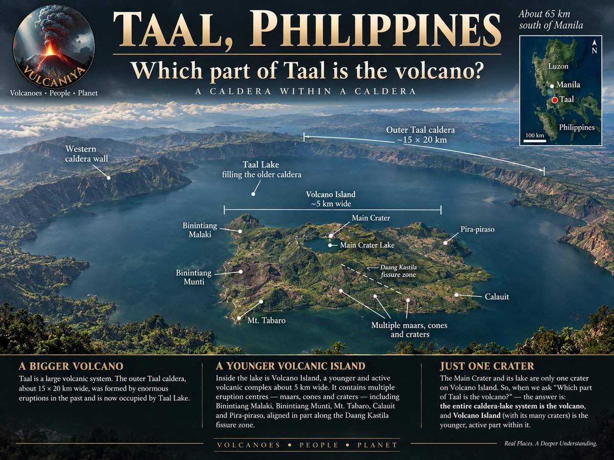
From the ridge at Tagaytay the answer looks obvious. A small island rises out of a wide lake, and everyone points at it and calls it Taal Volcano. The island is the youngest and smallest part of the system. The lake it stands in is the volcano too, and so is the ground under the town doing the pointing.
The depression holding the water is the Talisay caldera, roughly 15 by 20 kilometres, cut by prehistoric eruptions on a scale nothing in the written record approaches. Taal Lake covers about 267 square kilometres of it, the surface sitting only a few metres above the sea, and the deepest water reaching well over a hundred metres. Vents lie beneath the lake as well as on the island. What looks from the rim like a lake around a volcano is a lake filling one.
People live inside that structure, and the volcano rearranged where. In 1754 Taal produced the largest eruption in its historical record and put enough debris into the Pansipit River to close the lake's outlet to Balayan Bay. The water rose and drowned the shoreline. Taal, Bauan, Lipa, Sala and Tanauan were abandoned where they stood and rebuilt further back, which is why the old town of Taal is no longer on the lake it is named after, and remains of the earlier settlements are still reported underwater. Rain then diluted what had been an arm of the sea, and the marine animals shut inside either adapted or died out. The tawilis sold in the lakeshore markets, the only freshwater sardine anywhere, is one of the survivors, along with a trevally the fishermen call maliputo and one of very few sea snakes living entirely in fresh water. The tawilis has been listed as endangered since 2018, for reasons of fishing pressure and water quality rather than volcanism.
Volcano Island itself, about five kilometres across, is not a single cone either. It is a cluster of overlapping tuff rings, scoria cones, explosion craters and smaller centres, with the Main Crater and its own crater lake near the middle. A caldera holding a lake, an island in the lake, a crater in the island, a lake in the crater. Every eruption in historical times has come from that island, but not from the same opening in it.
That distinction has cost lives. The eruption of September 1965 did not come from the Main Crater. Explosions tore a new crater about 1.5 kilometres long on the south-western side of the island, water reached the rising magma, and ground-hugging surges of ash and steam swept outwards, across the water as well as the land. Around two hundred people were killed. The deposits those surges left became one of the cases on which the modern understanding of base surge behaviour was built.
The Main Crater took its turn on 12 January 2020, driving a steam-rich column to somewhere between ten and fifteen kilometres, closing Manila's airport and covering much of southern Luzon in ash. Activity since has settled into short bursts, phreatic and minor phreatomagmatic, a few minutes each. There have been many this year. Through June and July 2026 PHIVOLCS logged repeated events at the Main Crater, most producing plumes of a few hundred metres, one on 21 July reaching about 2.8 kilometres above the rim. All of it is happening within the young complex on the island, not through any movement of the caldera around it, which is worth holding on to when a report says Taal has erupted.
Alert Level 1 has held throughout, and PHIVOLCS is careful to call that unrest rather than quiet. The whole of Volcano Island remains a Permanent Danger Zone, with the Main Crater and the Daang Kastila fissure specifically prohibited and pilots told not to overfly. The prohibition covers the island. The caldera it sits in holds the lake, the fish cages, the boats out of Talisay and the towns that moved once already.
Vulcaniya | Volcanoes • People • Planet
Witori Caldera, West New Britain, Papua New Guinea
On 3 August 2002 an airline crew over New Britain reported ash rising past nine kilometres above the Hoskins Peninsula. Within days more than ten thousand people had left the villages around the volcano for Kimbe, fifty kilometres to the north, and the airstrips at Kimbe and Hoskins had closed under falling ash. The explosions gave way to lava within weeks, and the lava went almost nowhere. It ran a few hundred metres from a line of new vents, reached the wall of the Witori caldera, and turned to travel along it, north-east on one side and south-west on the other. Rabaul Volcano Observatory reported that the flows were staying inside the caldera. That is what lava at Pago has done for as long as there has been a Pago.
Pago is the cone in the middle of the caldera, and it is young. Estimates put its construction at less than 350 years ago, which is very little time in which to build a mountain 724 metres high, standing level with the rim of the depression it grew inside. About ten dacitic lava flows have issued from it, and between them they cover much of the caldera floor. The flows of the 1911 to 1918 eruption fill parts of the eastern and south-western floor. When the 2002 lava turned north-east along the caldera wall, it was blocked partly by the wall and partly by one of those older flows.
The container itself measures roughly 5.5 by 7.5 kilometres, and the collapse that made it is dated to about 3,300 years ago. It was not a single event in an otherwise quiet landscape. Five major explosive eruptions took place here between roughly 5,600 and 1,200 years ago, and several of them appear to have been associated with caldera formation. The gently sloping country outside the rim, the ground the plantations and the road now occupy, is built almost entirely of pyroclastic flow and airfall deposits from those eruptions.
People were living on that ground throughout. Archaeologists working on the Willaumez Peninsula have used the Witori ash layers as a dating framework for the whole regional sequence, and the layer known as W-K2, associated with the collapse, marks a break in it. Beneath the ash lie the large stemmed obsidian tools that had been made and traded here for millennia. Above it, in the soil that formed on the tephra, comes Lapita pottery. Robin Torrence and colleagues have argued that a considerable part of western New Britain was abandoned for at least 150 years after W-K2, and the question of whether the eruption helped end one cultural world and admit another remains open rather than settled.
The 2002 eruption offered a small, watchable version of the filling process. A Japanese team that reached the volcano in late August found lava issuing from four of five vents strung out north-west of the summit crater, the greatest volume coming from the lowest and outermost of them. Faults had opened along and across the line of vents, some with several metres of displacement, throwing down swaths of rainforest that were visible from the air. Ash deposits were thin, two millimetres three kilometres north of the craters and less than one millimetre at Hoskins. Effusion continued into 2003, adding the youngest sheet to the caldera floor.
Activity since has been explosive and brief. On 3 May 2012 Darwin VAAC tracked ash and steam to about 13.7 kilometres, drifting some 74 kilometres to the north-east, and in July further plumes reached 4.3 kilometres and carried nearly 300 kilometres south-west. That remains the last confirmed eruption. The caldera floor Pago has been resurfacing is now mostly its own rock: the 1911 to 1918 flows to the east and south-west, the 2002 field to the north-west, and beneath them the surface left when the ground came down.
Vulcaniya | Volcanoes • People • Planet