Tuesday Storm Outlook: Isolated to scattered showers & t-storms will begin tomorrow afternoon continuing into the night. There is a chance that some of these storms could become strong to severe, especially north & west of the Houston Metro tomorrow evening. #HOUwx#TXwx#BCSwx
#TAMUvsBAMA Wx: Bermuda High will be firmly entrenched in SE US yielding plentiful sunshine, hot temperatures, high humidity, and only a scant chance of an isolated afternoon shower or storm. Expect ESE wind at 5-10 mph. Kick/Half/End Temp: 91/92/88. #BTHObama!
Meanwhile, there are an amazing NINE other tropical cyclones or disturbances across globe! Never seen all basins this active at same time! Here is a beautiful satellite loop of Cat 5 Super Typhoon #Mangkhut with 168 mph sustained winds & 201 mph gusts! https://t.co/SEhYqORGWs
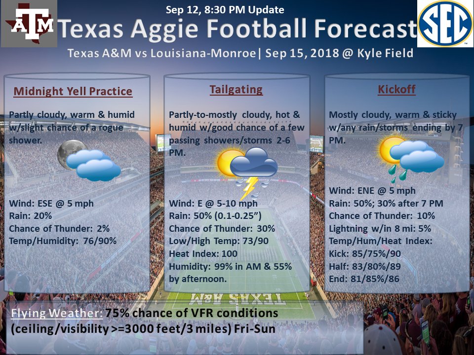
#TAMUvsULM Wx: Still watching 95L for development. At this time, what would be Kirk should stay well south Aggieland, but uncertain until center forms... Mostly cloudy, warm & sultry w/any rain or storm ending by 7 PM. ENE wind at 5 mph. Kick/Half/End Temp: 85/83/81. #BTHOulm!
Texans along coast need to pay close attention to 95L, which is currently over 88+ degree bath water & experiencing little shear! All models only forecasting a TS at worst, but we may have a rapidly intensifying storm named Kirkw/landfall w/in 48-72 hrs. https://t.co/YAE45RphLW
Life-threatening, catastrophic flash flooding and significant river flooding is possible over portions of the Carolinas and Mid-Atlantic states from late this week into early next week, as #Florence is expected to slow down as it approaches the coast and move inland.
Good news, bad news on #Florence. Good news is strong shear is forecast to negatively impact storm as it approaches the NC/SC coast. Bad news is that the tropical cyclone will still be a major hurricane as at least a Category 3. Hoping the shear weakens her down to a Cat 2!
@JayMagBQ87@megmagruder As of right now for most of Texas, Sunday does not look too bad. Just a slight chance of isolated-to-scattered showers and storms, but nothing too organized. What could be Joyce should be well south along TX/Mexico border, but still too early to be sure.
#TAMUvsULM Wx: Mostly cloudy, warm & humid w/50% chance of rain, decreasing to 20% by 7 PM. Rain chances may go up depending on track & timing of possible tropical cyclone (Joyce) now brewing in NW Caribbean. ESE wind @ 5 mph. Kick/Half/End Temp: 83/81/79. #BTHOulm!
#Florence currently withstanding 20-25 knots of wind shear. If this high shear persists, she may weaken to a Cat 2 or 3. But, these storms can create their own sheltered environments under right conditions, which can protect them from the damaging effects of strong wind shear.
Deep rotating convection (aka Vortical Hot Towers) near center leading to rapid spinup of Hurricane #Florence into Cat 3 storm. Likely to be strong Cat 4 storm when she makes landfall very early Fri AM along SC coast. Very dangerous storm! Take action now! https://t.co/Sraiqlx5Ha
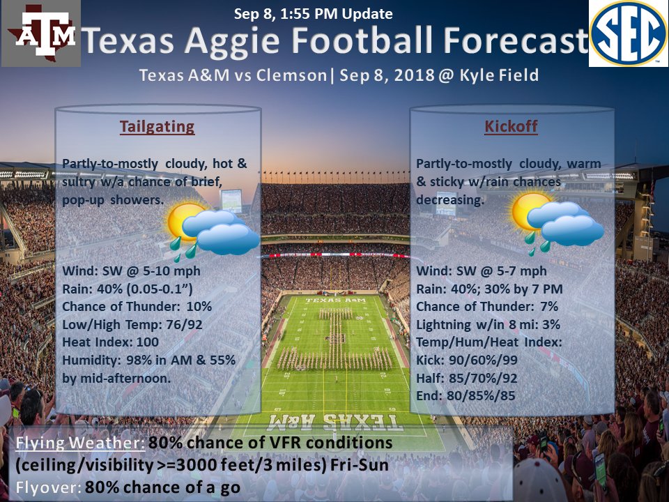
#TAMUvsCLEM Wx: Feeling the westerly outflow air, which will only reinforce stability over Kyle. We may skate by with light rain if new cell from outflow misses us to west. Other heavier cell is skirting to east.
#TAMUvsCLEM Wx: Outflow boundary to west may fire up a light cell to SW, which will impact Kyle around 5:20-5:30. Will help completely clear things out for game.
#TAMUvsCLEM Wx: Cell about 14 miles SW of Kyle may hold together & give us a 15-20 minute shot of moderate-to-heavy rain about 5:20-5:30. Will be done by kick. There are a few strokes of lightning. After this cell pass, should be good to go outside of a few passing showers.
#TAMUvsCLEM Wx: Due to front slowing down significantly, rain chances for the game have decreased to 40% to start & 30% by 7 PM. Heavy rain should hold off until tomorrow morning/early afternoon. Had a feeling models would do as they always do...bring first fronts in too fast.
Folks along SC/NC coast need to pay close attention to soon-to-be Hurricane Florence. She is about to have favorable conditions for rapid intensification w/in the next 2-3 days. May re-curve, but most models showing a landfall along SC/NC coast by Tues/Wed next week. Prepare now!
#TAMUvsCLEM Wx: Cloudy, warm & humid with rain/storms ending 6-7 PM. Best chances for rain 2-5 PM, but will not rain entire time. Chance of lightning w/in 8 miles of stadium is ~ 5%. NW wind @ 5 mph. Kick/Half/End Temp: 85/82/80. Heat index 94 to start & 86 to end. #BTHOClemson!