Layer up, Melbourne, and don't forget the umbrellas. This Wednesday is chilly but Thursday could potentially be both the wettest and coldest day of 2026 to date.
https://t.co/shqhxcRqtq
#Tasmania and #Hobart just had their warmest May on record based on maximum temperatures, with Victoria and New South Wales also having an exceptionally warm month. 🌡️ https://t.co/nahKsoT5wb
A strong low pressure system and associated #coldfront are funnelling wild #winds across southeastern Australia this Tuesday, with severe weather warnings for potentially damaging winds issued for parts of #Victoria, #SouthAustralia, #NSW, and the #AustralianCapitalTerritory. ⚠️🌬️
https://t.co/ypRd3Js08J
Which part of Australia had the coldest start to winter? 🌡️
Today, June 1, marks the first day of #winter in Australia. For many, it was a fittingly cold start to the season, with temperatures dropping below zero degrees in four states and territories, and even dipping to a nippy 1.1°C in Queensland! https://t.co/0ixDoS1rtU
A light dusting of fresh #snow has coated the alpine areas of #NSW, #Victoria and #Tasmania to start winter, with heavier snowfalls likely later this week just in time for Saturday’s official opening of the 2026 Australian ski season. ❄️
https://t.co/0wkoaQAZNN
Watch as this 'bombing' low 🌀 rapidly intensifies as it impacts the southwest of WA. The central pressure fell 18hPa in these 12 hours.
While much of the heaviest rain has now fallen (widespread 20-50mm), winds are yet to peak, reaching their maximum around 6-8pm WST Sunday night.
⚠️Forecast weather impacts to come:
💨 Wind gusts of 125-155km/h along the coast, and above 90km/h possible from Leeuwin to Albany, inc. Perth
🌊 Significant wave heights of 6.5-7.5m (maximum heights up to 15m) at Rottnest Island and the exposed coasts. Tides will also be abnormally high, potentially exceeding the highest tide of the year
🌪️ Cold-season tornadoes possible with isolated thunderstorms. A further 15-30mm of rainfall is forecast
To find warnings, observations and more information visit https://t.co/hM7JMtGm8C
Damaging winds are likely for #Perth and parts of southwest #WesternAustralia, especially near the coast, as a cold front roars in later this weekend.
https://t.co/Ibl7lb5fu9
Heavy rain and #thunderstorms inundated parts of #NSW on Thursday into Friday morning, with the State Emergency Service performing five #flood rescues and responding to more than 300 incidents in 24 hours. ⚠️
https://t.co/rjkmmcgIry
🎥 This video shows enhanced water vapour satellite images from the last three days as an upper-level cut-off low develops over southeastern Australia. ☔️⚡️ This system is causing areas of heavy rain and thunderstorms across parts of Queensland and New South Wales today.
Parts of #Queensland and #NSW will continue to endure heavy #rain and severe #thunderstorms during the next 24 hours. ☔️⚡️ This severe weather follows an outbreak of storms that produced almost half a million lightning strikes over eastern Australia on Wednesday and Thursday morning.
https://t.co/X4TZOQZJwf
Tropical moisture has made its way south to #Tasmania, delivering some of the state’s heaviest daily #rainfall totals on record for May. ☔️
https://t.co/C0D4SpI4RU
That little purple patch near Perth means as much as 100mm of rainfall over the next week, according to one model, as a prolonged showery spell marks the transition to winter. https://t.co/dHezNz3JhK
Parts of the #UnitedKingdom have experienced their warmest spring day on record this week, with the national record obliterated by 2°C, according to provisional data from the Met Office. 🌡️
https://t.co/OoWP0KzCy8
These enhanced water vapour satellite images show a cut-off low developing over South Australia on Tuesday, as moisture-laden tropical air spreads across the country's southeast.
ℹ️ This type of satellite imagery is useful to show how moisture in the tropics can produce rain and thunderstorms across southern Australia after travelling for thousands of kilometres.
Heavy #rain has fallen across a wide area of eastern Australia, with rainfall totals exceeding 50 mm in the 24 hours to 9am AEST on Tuesday at several locations in the Central West of #NSW. 💧 The city of #Dubbo led the way with 59.4 mm. https://t.co/c6Z9r7D2T8
🎥 This radar loop shows rainfall across NSW from 1am to 9am AEST on Tuesday, May 26, 2026.
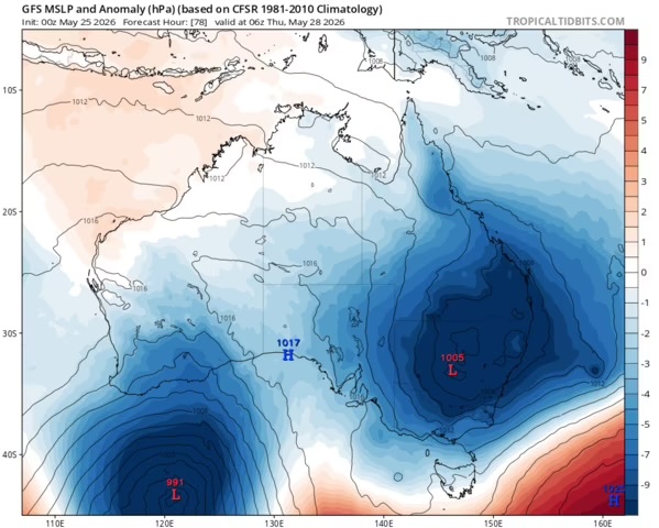
A large, complex system of low pressure is establishing itself over the southeastern mainland this week, in an unusual set-up for the last week of autumn. https://t.co/vlBwV54aw9
📷 Image: Predicted mean sea level pressure anomaly across Australia for Thursday, May 28, 2026. Source: Tropical Tidbits
A dynamic weather pattern will cause #rain and #thunderstorms over large areas of eastern, southern and western Australia this week. ☔️⚡️ This wet weather will affect part of every state and territory, with heavy falls and #flooding possible in at least two states – most likely #NSW and #Tasmania.
https://t.co/6YWPayCeQh
Small uncrewed drones will be flown into hurricanes this season, capturing data that should help improve the accuracy of hurricane intensity forecasts.
https://t.co/DDGrpIr0Nh
A change in the weather pattern over Australia will cause a dynamic mix of weather in the country’s southeast and southwest next week, with #rain, #thunderstorms ⚡️, #snow and potentially damaging winds on the cards. https://t.co/4uVqziQ6hA
#Snowmaking kicked off this week in some ski resorts, in preparation for the official 2026 Australian #snow season, beginning on Saturday, June 6. ⛄️
Let's look at how snowmaking works, the conditions required, and if we'll see natural snow before the ski season opening.
https://t.co/Hmus8NGMJp