Nicely treated roads ahead of the big #snow in Louisville, KY with a winter storm warning in effect! Snow begins with the first wave on Saturday @accuweather
Last night, the 53rd Weather Reconnaissance Squadron flew into the eye of Hurricane Erin—and captured imagery of the breathtaking stadium effect.
These missions provide critical data to the NHC to improve forecasts, helping keep communities safe before the storm makes landfall.#readynow #weatherready
Wow. 298 tornado warnings have been issued since Wednesday morning.
The Level 5 out of 5 "high risk" came by surprise to many (even experienced meteorologists), but the forecaster who issued it – Christopher Broyles at the Storm Prediction Center – specializes in sniffing out sneaky high-end setups.
On April 7, 2006, Broyles issued the first ever day-in-advance high risk for an anticipated tornado outbreak that would go on to spawn 73 tornadoes. The Department of Commerce awarded Broyles with a Silver Medal as a result of his prescient forecasting.
We also had two "tornado emergencies" issued – one for the Lake City, Arkansas tornado, and another for the tornado that hit Slayden, Mississippi.
Both were likely EF4 or EF5 damage-producers, and were most certainly at EF5 intensity at times given the magnitude of the damage.
Meanwhile, I'll have more coverage of the coming days' storms in the MyRadar Weather Radar app.
Can we give the NWS / SPC / Chasers / Streamers / Local News a huge thank you for helping warn and give eyes during these major severe weather outbreaks? Incredible stuff everyone. People in multiple sectors coming together to save lives. This is why we need it.
We're all good here at the office, the circulation JUST missed us to the south, might have hit the airport, too dark to tell. We did lose power and we are on generator power. Be safe y'all!!!
NEW: NOAA operations slowed by mandate for Commerce Secretary to approve ALL contracts/contract extensions above $100,000. This nearly led to a significant deterioration of Nat'l Weather Service operations last night. https://t.co/Cwduv5prA4
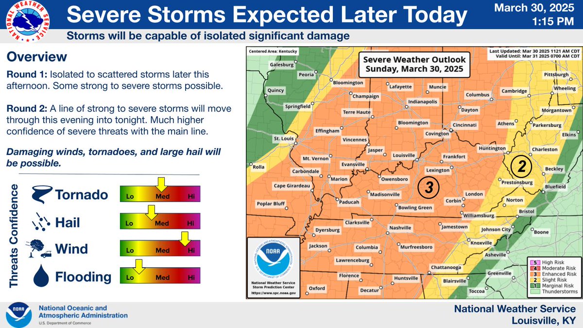
An established line of severe storms stretching from north & central IN, southern IL into MO will move in later this evening. Earliest timing for southern IN appears to be 7-10pm with the Louisville 9-10p and Lexington 10p-12a. Damaging winds, Large hail, & tornadoes possible.
The midday update brings little change for our area. Some isolated storms may develop this afternoon ahead of the main line, but the overall greatest confidence in severe threats is with the line this evening and tonight. All hazards are possible, take the time now to have a plan
@sambrandt99 I’ve been a Learning & Development professional for nearly 15 years, and this is one of the best examples of micro-learning I’ve ever seen, if not the best. Extremely effective, especially for such a complex subject, and SO cool.
Earlier #tornado with LARGE debris ball moved right over #Taylorsville#Mississippi (#MSwx ) which is within the HIGH RISK area early Saturday afternoon (March 15) #TornadoOUTBREAK
(@wdam )-TV: "Oh GOD, it went right over Taylorsville, it went right over Taylorsville"
This is the aftermath on Saturday morning from the fires in Stillwater. Crosswinds & Pecan Hill neighborhoods shown here. The footage ends at the entrance of Boulder Creek off of Range road. Pray for our community 🙏