📢 Recommended by Tri-Cities Weather & Alert Crew! 🌪️📻
Stay storm-ready with the Midland WR120 NOAA Weather Radio—instant alerts even when power & cell service go out!
🔗 Get yours 👉 https://t.co/JoRbzvyAY3
(Affiliate link: I may earn a commission at no extra cost to you.)
Flood Warning for Hancock, TN and Lee, VA until 12:00 AM 6/20/26. Minor flooding of Powell River near Jonesville is forecast. Don’t drive through flooded roads; turn around and avoid low-water crossings.
Flood Advisory continues for Lee, Russell, Scott, Wise, and City of Norton, VA until 12:00 PM 6/19/26. Small stream flooding from excessive rain. Minor flooding in low-lying/poor drainage areas; flows elevated. Turn around, don’t drown—avoid flooded roads.
Flood Advisory for Lee, Russell, Scott, Wise, and City of Norton, VA until 9:00 AM EDT. Minor flooding possible from 3-5" rain; river/stream flows elevated. Turn around, don’t drown—avoid flooded roads.
Flood Warning continues for Lee, Russell, Scott, Wise, and City of Norton until 6:00 AM EDT. Flooding from excessive rainfall is imminent/occurring; rivers and low-water crossings may be inundated. Turn around, don’t drown—avoid flooded roads.
Flood Warning for Lee, Russell, Scott, Wise, and City of Norton until 6:00 AM EDT. Flooding of rivers/creeks and low-water crossings is imminent. Turn around, don’t drown—avoid flooded roads and don’t drive through water.
(Event continued) Flood Watch for Hancock, Hawkins, Sullivan, Johnson & Others until 2 AM EDT Fri. Excessive rainfall may cause flooding of rivers/creeks and low-lying areas. Avoid flooded roads and turn around.
(Event extended) Flood Watch for Ashe NC & Others until 4 AM EDT Fri. Excessive rainfall may cause flooding of rivers/creeks and low-water crossings. Avoid flooded roads and turn around.
Flash Flood Warning for Lee, VA, Russell, VA, Scott, VA, Wise, VA & Others until 12:45 AM EDT. Heavy rain may cause flash flooding of creeks/streams, roads, underpasses. Turn around, don’t drown; avoid flooded roads.
(Event continued) Flood Watch for Ashe & Others until 2 AM EDT Fri. Excessive rainfall may cause flooding of creeks/streams and low-lying areas. Expect repeat heavy rain; storms may bring more heavy rain. Avoid flood-prone roads.
Special Weather Statement for Sullivan, Johnson, NW Carter & Washington until 7:45 PM 6/18/26. Wind gusts up to 40 mph and pea-size hail possible with strong storms. Radar indicated. If outdoors, seek shelter inside a building.
Severe Thunderstorm Warning remains in effect for Grainger, Hamblen, Hawkins, and Jefferson, TN until 7:15 PM 6/18. 60 mph wind gusts and 0.75 in hail possible. Radar indicated. Move to an interior room on the lowest floor.
Flood Advisory for Carter, Johnson, Unicoi, and Washington, TN until 10:00 PM 6/18/26. Flooding from excessive rain is expected. Minor flooding in low-lying/poor drainage areas. Turn around, don’t drown—avoid flooded roads.
Severe Thunderstorm Warning for Hawkins, TN & Others until 7:15 PM. 60 mph wind gusts and 0.75" hail possible. Radar-indicated storm near Dandridge moving NE. Move to an interior room on lowest floor.
(Event continued) Flood Watch for Lawrence, KY & Others until 2 AM EDT Fri. Flash flooding possible from excessive rainfall. Torrential downpours may repeat. Avoid low-lying areas and turn around if flooded.
Tornado Warning for Lee, VA until 5:30 PM 6/18/26. Tornado possible with radar-indicated rotation. Flying debris will be dangerous; mobile homes may be damaged. Take cover now in a basement/interior room away from windows.
Special Weather Statement for Hancock, Lee, Scott until 4:00 PM 6/18/26. Wind gusts 50-55 mph and pea-size hail possible. Radar indicated. Secure loose items; if outdoors, seek shelter in a building.
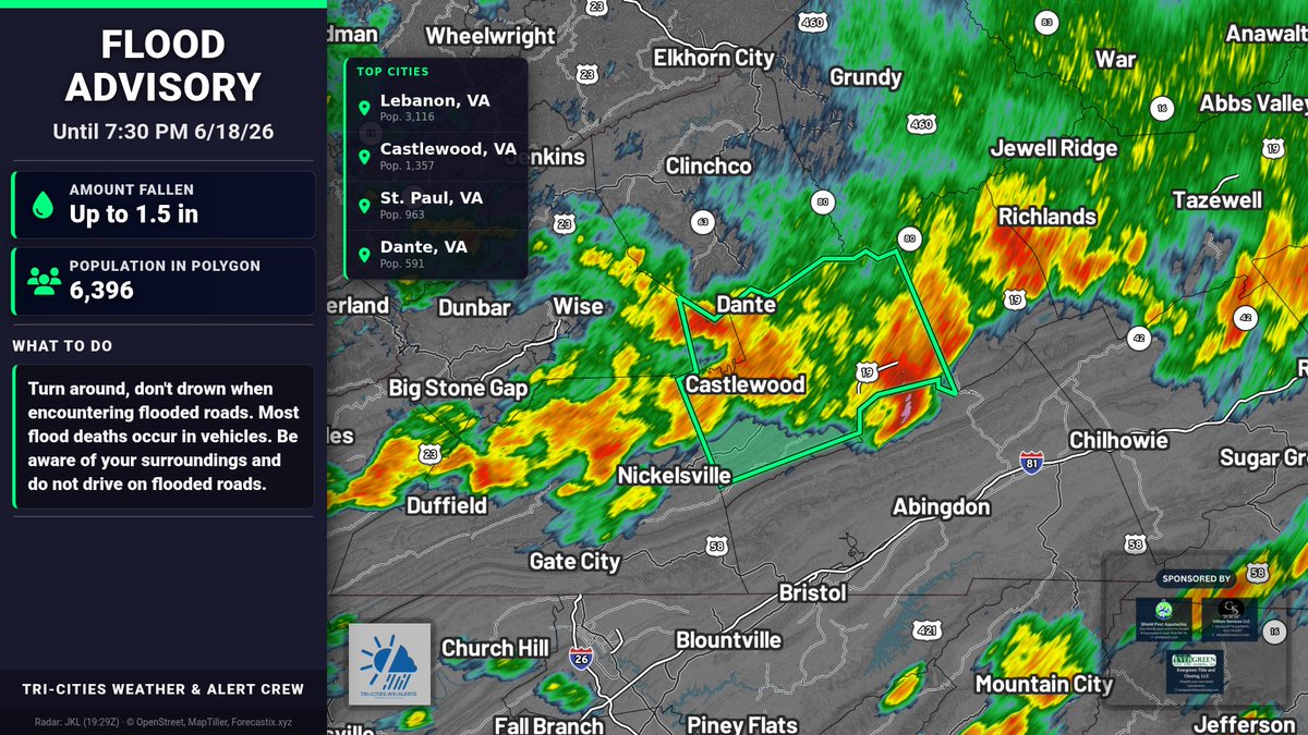
Flood Advisory for Russell and Wise, VA until 7:30 PM 6/18. Flooding from excessive rainfall is expected. Minor flooding in low-lying/poor drainage areas. Turn around, don’t drown—avoid flooded roads and don’t drive through water.
Severe Thunderstorm Warning remains in effect for Russell and Washington, VA until 3:45 PM 6/18. 60 mph wind gusts and penny-size hail possible. Radar indicated. Expect damage to roofs, siding, trees. Take shelter indoors.
Severe Thunderstorm Warning remains in effect for Russell and Washington, VA until 3:45 PM. 60 mph wind gusts and penny-size hail possible. Radar indicated. Move to interior room on lowest floor; watch for tornadoes.
Severe Thunderstorm Warning for Russell, Scott, Washington, and Wise, VA until 3:45 PM EDT. 60 mph wind gusts and 0.75 in hail possible. Damage to roofs, siding, trees. Move indoors to lowest floor; watch for tornadoes.