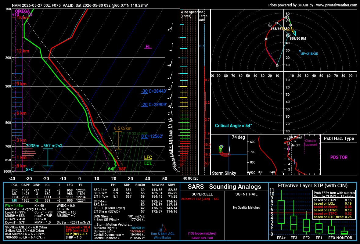
While there have been many PDS Tor Hazard soundings, this one might be the most improbable. The sounding was taken along the Alberta/Northwest Territory border and likely the first ever such hazard for anywhere north of 60N
@amarkowitzWX Considering this data ends in the early 2010s... data will be different with more recent tech and changes to philosophy in warning storms.
Typhoon #Sinlaku is an absolute behemoth out in the West Pacific. It’s rapidly approaching becoming the strongest typhoon/storm in the month of April worldwide. What a start to the WPAC typhoon season.
Typhoon #Sinlaku is an absolute behemoth out in the West Pacific. It’s rapidly approaching becoming the strongest typhoon/storm in the month of April worldwide. What a start to the WPAC typhoon season.
Three years ago was the most insane tornado evolution I have ever seen. A cone tornado chews up unplanted farmland, taking on a dirty barrel shape before the collar cloud sinks into a mile-wide tornado. These four clips happened over about 10 minutes.
3.31.2023 - Hedrick, IA
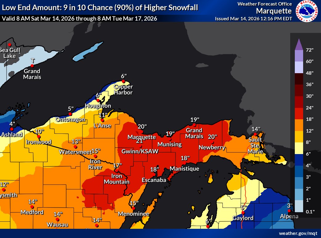
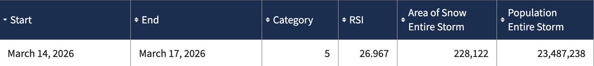
This blizzard was rated as an RSI category 5 which puts in the upper echelon of all snowstorms in recent history as the 7th highest rated storm across the entire country. Furthermore, this was the first storm >20 since 2016 and the first for the Upper Midwest Region since 1991.
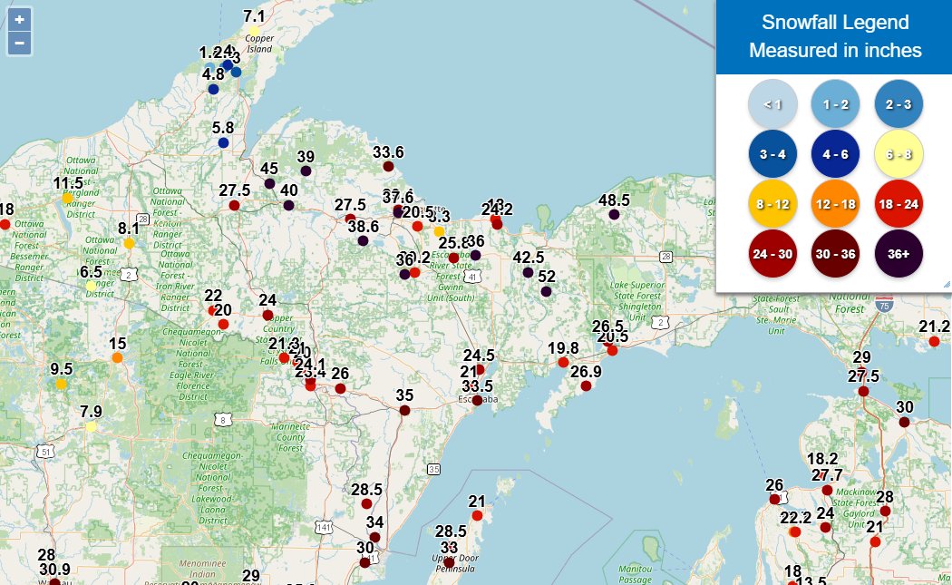
While the storm shifted a tad with the heaviest snowfall totals, the end result was widespread 36-50+" snowfall reports across the UP. It's hard to think of any other title than a historic blizzard for this storm in an area that is already used to a lot of snow.
Round Lake Michigan picking up 52" in this single storm is quite notable in context. Outside of the lake effect belts and the higher terrain of the West/Northeast very few places average >50" over the entire season(!)
While the storm shifted a tad with the heaviest snowfall totals, the end result was widespread 36-50+" snowfall reports across the UP. It's hard to think of any other title than a historic blizzard for this storm in an area that is already used to a lot of snow.
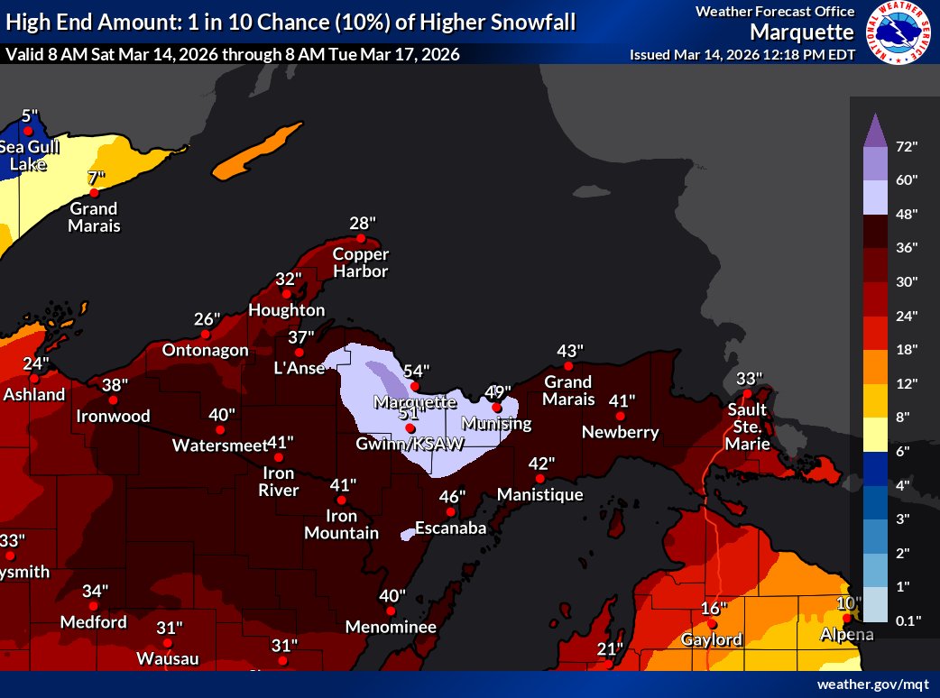
These are some of the most absurd snowfall maps I've seen for a synoptic snowstorm. Explicit 2-3+" snowfall totals with the possibility for higher depending on where you get terrain + lake enhancement. The UP is in for a truly historic blizzard through early next week.
To put this into context, just a few weeks ago we had a blizzard off the east coast that had isolated 36"+ reports. This blizzard has the potential for entire counties to completely surpass that total over a much greater area with winds that will likely be even stronger.
These are some of the most absurd snowfall maps I've seen for a synoptic snowstorm. Explicit 2-3+" snowfall totals with the possibility for higher depending on where you get terrain + lake enhancement. The UP is in for a truly historic blizzard through early next week.
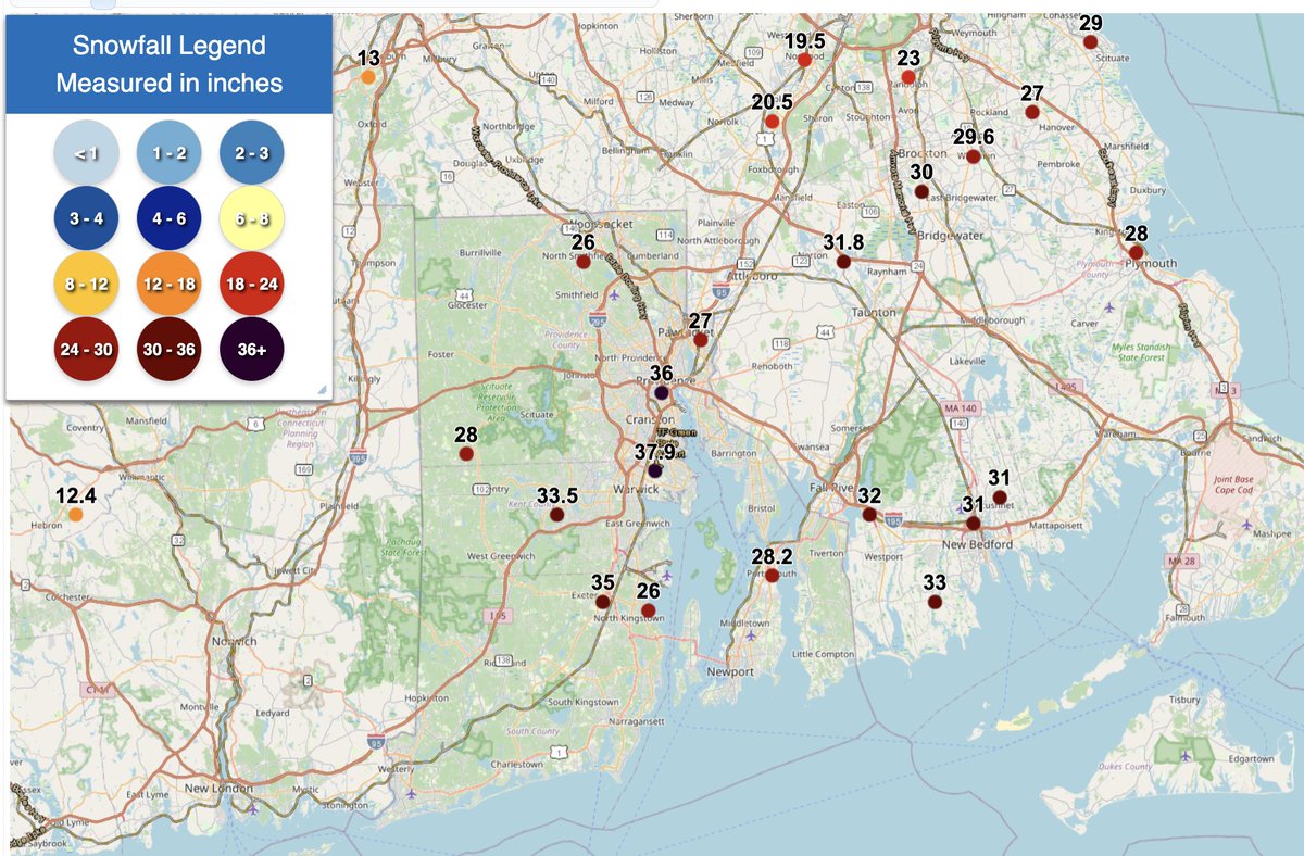
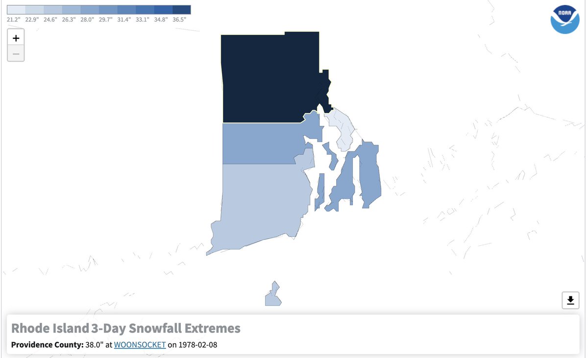
Given contextual snowfall totals in the mid to upper 30s & this being an official measuring spot as opposed to COCORAH/COOP observer, there is a decent chance this new record would hold up against scrutiny and be officially recognized.
Providence is now at a whopping 37.9" and should it receive another 0.2" of snow from the current snowstorm (it's still snowing lightly), they will set a new the state snowfall record per NCEI. #RIwx
Non-Zero chance that Rhode Island breaks their all time snowfall record. 38” is their highest (Blizzard of 78) and so far we’ve seen reports closing in on 26” thus far. Another few hours of this monster snowfall band and some state records could be in danger of being toppled.
Non-Zero chance that Rhode Island breaks their all time snowfall record. 38” is their highest (Blizzard of 78) and so far we’ve seen reports closing in on 26” thus far. Another few hours of this monster snowfall band and some state records could be in danger of being toppled.
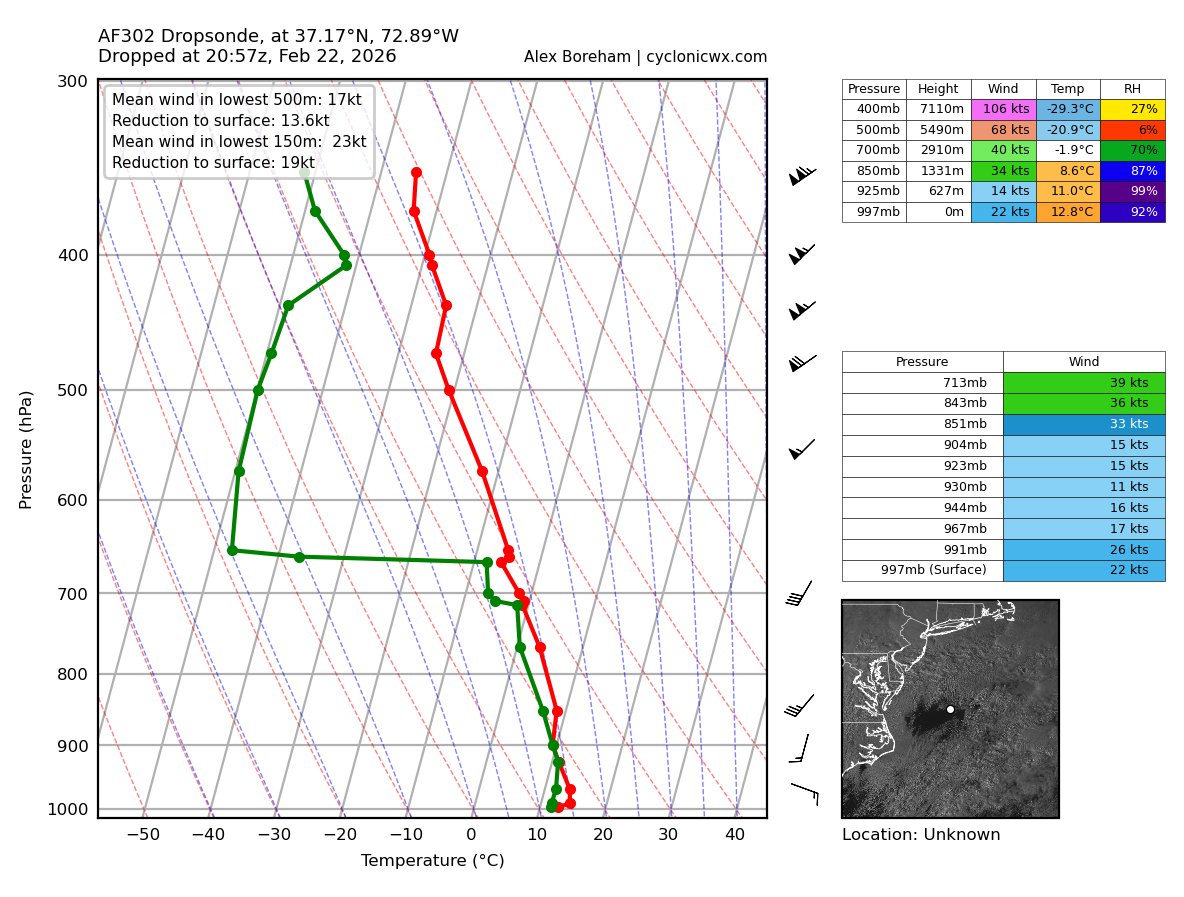
Pretty cool that we had recon sample the "eye" of this blossoming Noreaster. While not as calm as the eye of a prototypical tropical cyclone, the surface was fairly calm with a slight wind shift from the SW to the S & ESE symbolizing the unstacked & sheared nature of the cyclone.