I have signed off as the morning meteorologist at 25News — I’m very thankful for the opportunity to share the forecast with central IL each morning!
I am excited to share that I have accepted a job with @NWSTwinCities. I’m ready to get to work — on the other side of the camera!
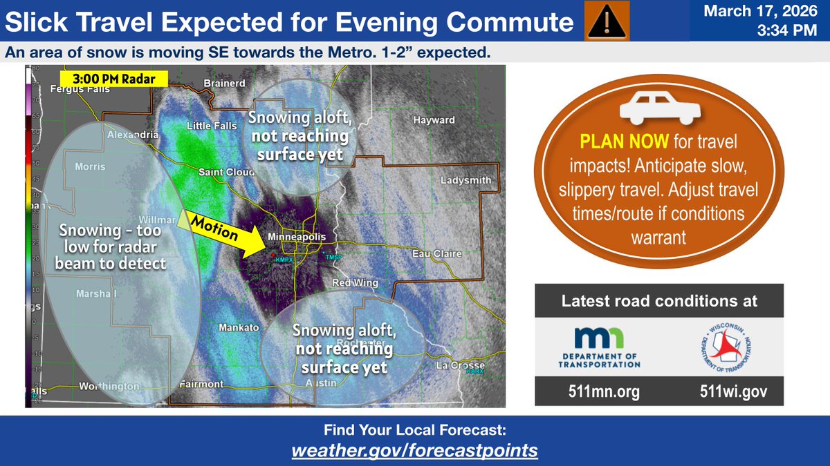
Light snow will move into the Twin Cities Metro in the next few hours, creating a slick evening commute. Total accumulations will only be 1-2 inches. The timing of the snow will create a difficult evening commute and you should anticipate slow travel.
#MNwx#WIwx
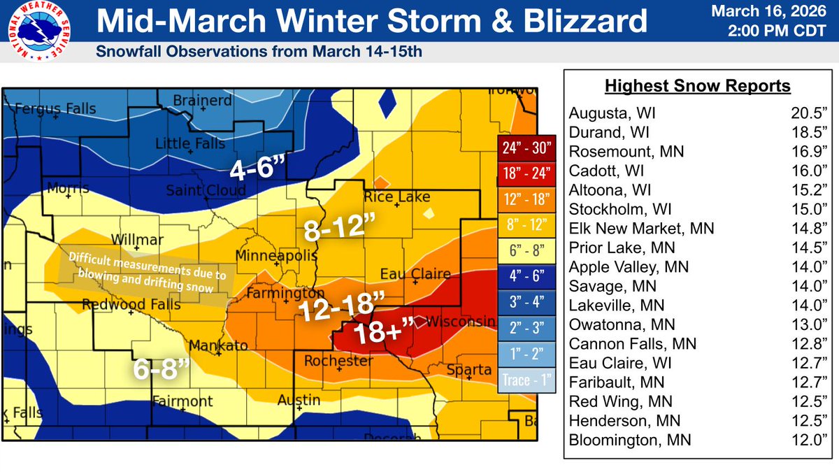
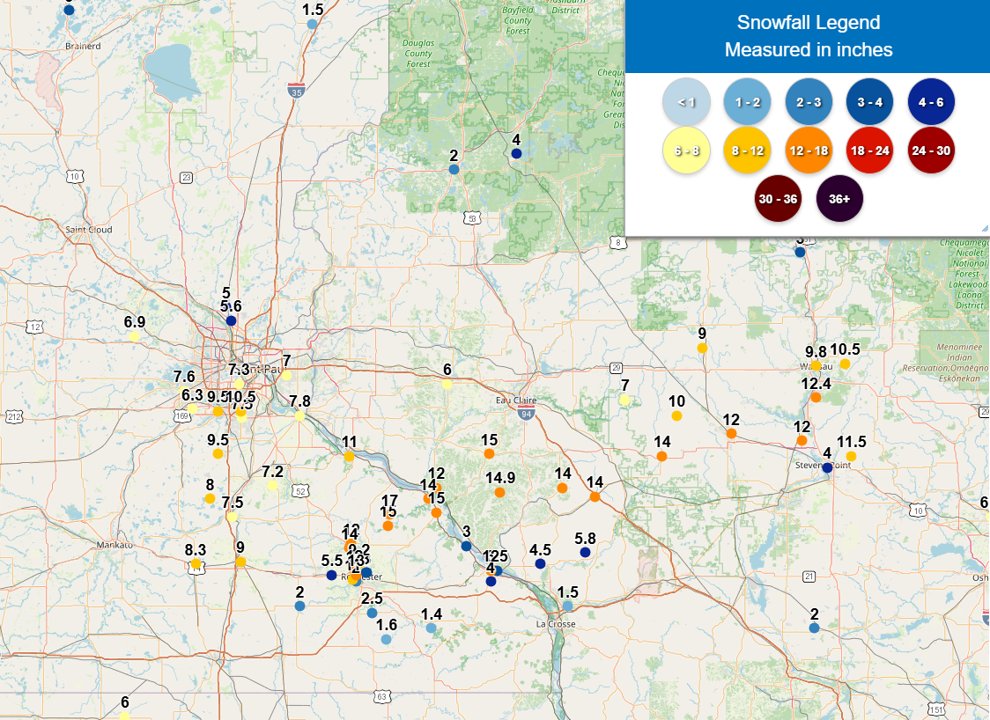
Thank you to everyone for the reports! The band of greatest snow amounts fell between the southern Twin Cities metro & Rochester and east into Wisconsin on March 14-15th #mnwx#wiwx
Phase 1 of the storm produced 7-10" of snow in the Twin Cities metro, with it really slamming north of Rochester over to Wausau with 12-17" of snow. Phase 2 extends back to central SD and will last most of the day, road conditions aren't great! #mnwx#wiwx
This is a great thread from an outstanding meteorologist at NWS Chanhassen about model interpretation and dealing with snow totals. Don't be fooled by various CAMs shifting north and south.
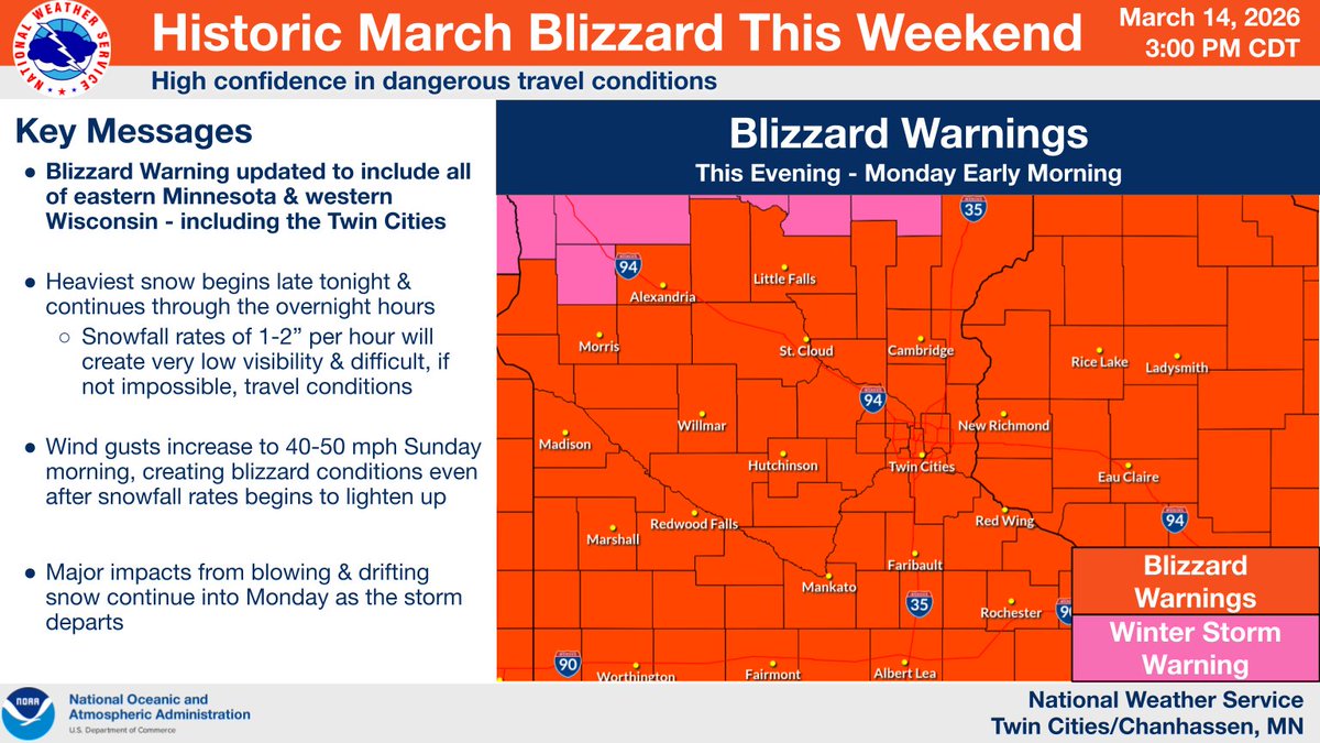
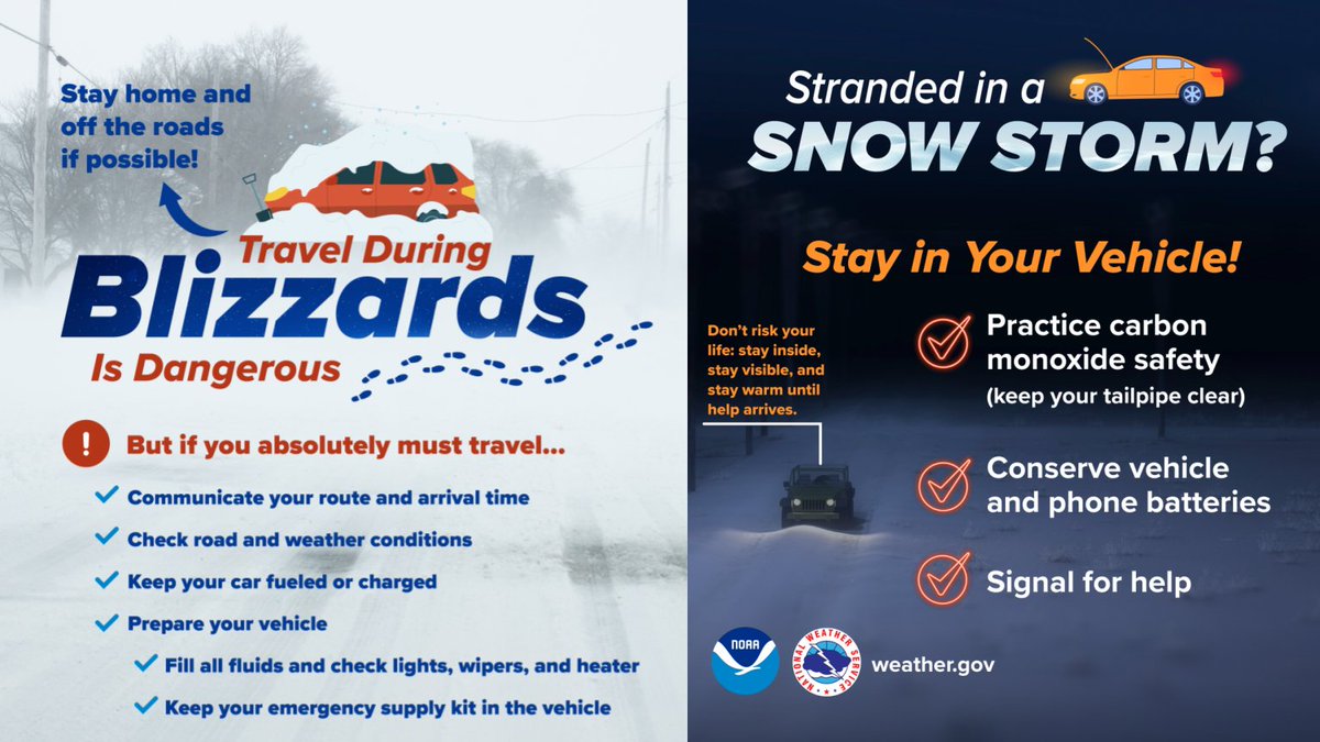
***HISTORIC MARCH BLIZZARD THIS WEEKEND***
Blizzard Warning updated to include all of eastern Minnesota & western Wisconsin - including the Twin Cities Travel will be very difficult to nearly impossible by early Sunday morning.
#mnwx#wwix
This! 👏 🧵 @BillBorghoff
Observing big shifts in long range CAM guidance has often added uncertainty in the days prior to a winter event.
By integrating ML solutions (AIFS/Ens), we’ve been able to sniff out the noise & keep a consistent message.
Bill explains ⬇️ ⛄️ #mnwx
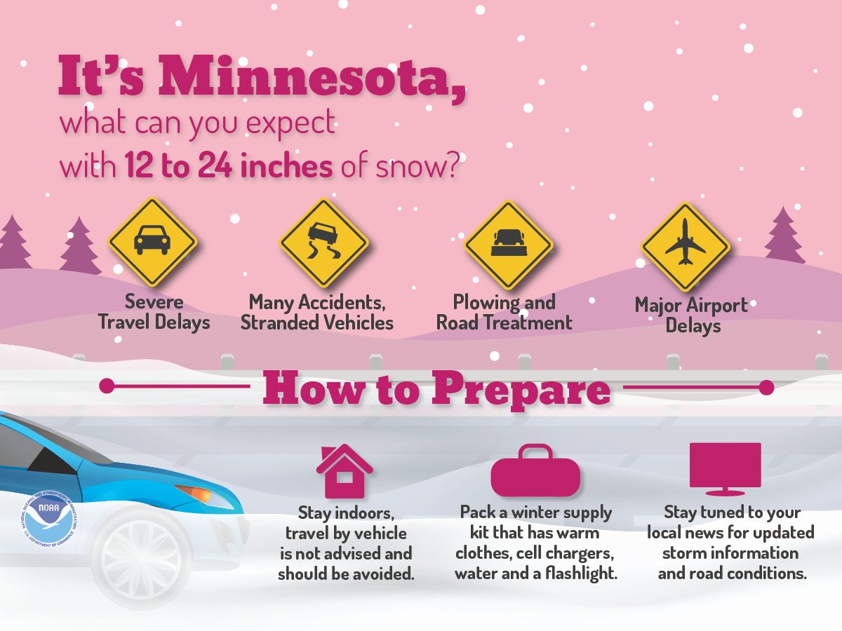
There is very little doubt the Twin Cities will have at least 12 inches of snow. Several members also now have 20 inches at a 10:1 ratio. This would be one of the heaviest snowstorms on record. It is important to know how to interpret models....
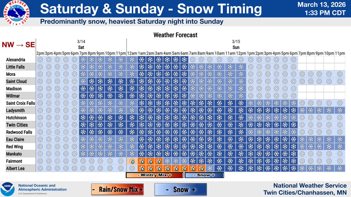
***MAJOR WINTER STORM THIS WEEKEND*** Travel conditions are expected to become very difficult to nearly impossible by early Sunday morning due to the combination of accumulated snow, snowfall rates of up to 2" per hour, and increasing northerly winds. https://t.co/OS2u4brFmw
• Very windy tonight with gusts of 50-60 mph into tomorrow AM
• Brief whiteout conditions tonight with snow squalls & 50+ mph winds. Heaviest snow across western WI.
• This Weekend: major winter storm impacts MN/WI.
12+" possible from southern MN - western WI.
#mnwx#wiwx
The official morning low was -21° at MSP Airport. Below is a map of observed morning lows across the region.
In addition, observed wind chills were as cold as -50° at Owatonna & Alexandria!
Here is a full list of the coldest wind chills --
https://t.co/XwOD04JK7K
Our office in Chanhassen has observed at least a 1” snow depth at 12z dating back to 11/26. It was looking like a close call with the recent thaw, but Mother Nature has supplied more snow just in time! ⛄️ #mnwx
It is officially a record setting afternoon! 🌡️
MSP's high of 72° sets a new daily high temperature record. The previous record was 71° (1990).
St. Cloud's observed high of 68° ties the old record, which was also set in 1990.
#mnwx
Incredible loop…. NNE LES events impacting SW Lake Michigan are rare! Neat to see big totals west of I-65 in Lake county for once.
I’ll admit just that I have just a little jealousy from MSP! ⛄️