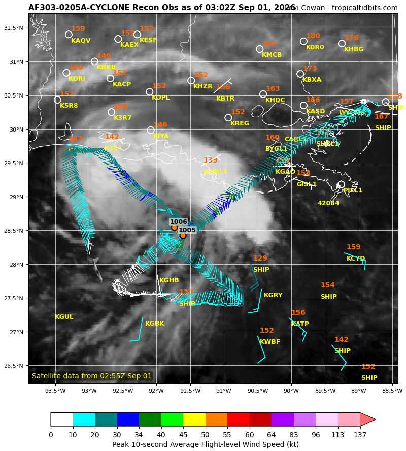
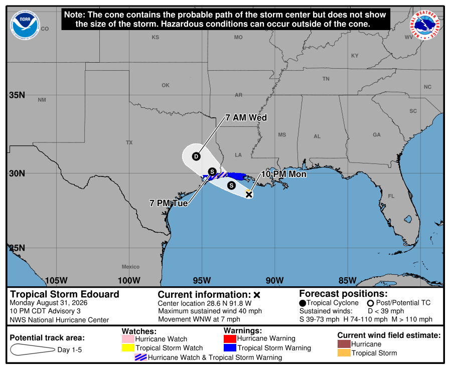
We now have Tropical Storm #Edouard in the Gulf with max winds of ~40 mph. A recon aircraft found that the central pressure fell considerably to ~1005 mb during the day, associated with a tight and well-defined core wind field. The storm's central convection has waned somewhat in recent hours, which will likely stall intensification until a new burst of thunderstorms ignites.
The compact nature of the wind field increases the risk of Edouard gaining a quick rush of strength before landfall in eastern #Texas or western #Louisiana tomorrow, as small storms are more prone to rapid intensity changes. Accordingly, @NHC_Atlantic has issued a Storm Surge Warning and a Hurricane Watch along portions of the coastline.
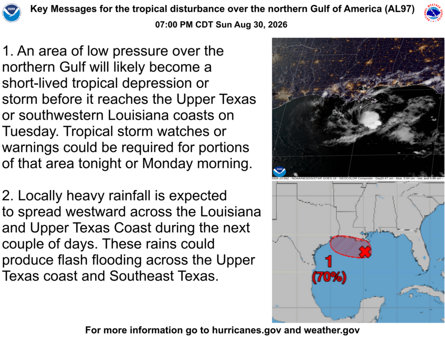
Aug 30 7PM CDT: Here are the latest key messages for the disturbance in the northern Gulf of America #AL97 Interests along the southwest Louisiana and Upper Texas coasts should monitor the progress of this system, as tropical storm watches or warnings could be required for portions of the area later tonight or Monday morning. For the latest information visit https://t.co/Wq6ZtKfHp9
🌀 Sunday afternoon video update on a new tropical disturbance in the Gulf expected to impact portions of #Texas and #Louisiana, and the remnants of Tropical Storm #Dolly near #PuertoRico
The 12z HWRF re-develops Dolly in the Gulf and has it off the west coast of Florida on Friday. As with previous model runs, the other 3 hurricane models (HMON, HAFS-A, HAFS-B) do not re-develop Dolly.
TROPICAL UPDATE: To me it appears like it's a tropical system already, but the NHC has bumped odds to 90%. I believe we'll get a cone at 11 AM for either a Tropical Depression or a weak Tropical Storm #Dolly. Either way, rougher dynamics ahead this weekend with higher shear and drier air. It's going to have to fight to stay alive.
President Trump is ending America’s dependence on foreign supply chains and our adversaries.
That’s why the @DeptofWar, alongside our partners at @SBAgov, is reestablishing the Smaller War Plants Commission.
A tropical wave leaving Africa has a decent chance to become a tropical storm as it tracks across the eastern and central Atlantic this week. Dubbed "Invest #96L," its surroundings generally favor development short-term, as the Saharan air mass to its north is less dry and deep than usual. Models agree on a west-northwestward track that would bring the system near or north of the Lesser Antilles in 6-7 days.
96L will likely encounter a less favorable environment later in the week as it nears a persistent zone of elevated wind shear over the central Atlantic. While earlier waves have been destroyed entirely by this zone, it is now peak hurricane season, so waves like 96L may survive long enough to get through the zone. It's too early to know whether 96L will stick around beyond this week, but it is a system to watch. The National Hurricane Center currently gives 96L a 60% chance of becoming a tropical cyclone.
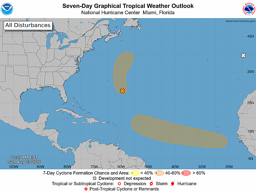
The 2 PM outlook has raised development chances on 95L southeast of Bermuda to 40% as it continues to show some signs of organization. The area of interest in the MDR remains at 50% development chances.
Aug 24 8AM EDT: NHC is monitoring two areas with a medium chance of development. #AL95 is located SE of Bermuda, and a tropical wave in the tropical Atlantic.
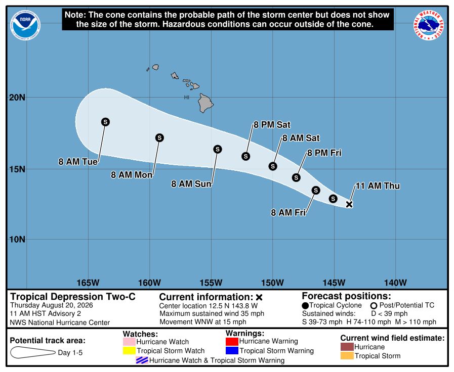
Tropical Depression "Two-C" (TD2) has formed southeast of #Hawaii. It will be named "Moke" if it strengthens into a tropical storm. Some adverse environmental conditions are expected to keep TD2 below hurricane intensity as it tracks west-northwestward over the rest of the week.
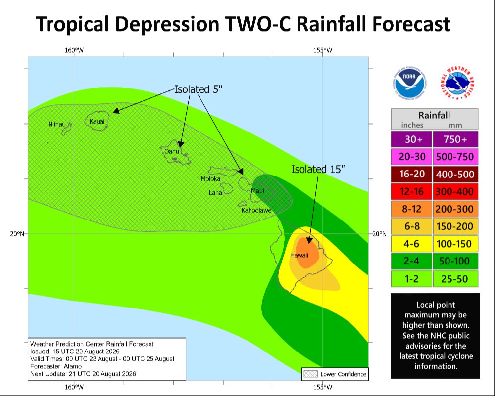
Models are coming into better agreement on TD2 tracking south of the Hawaiian Islands, but the key will be exactly how distant. Heavy rains and strong wind gusts may still occur in at least the Big Island, and any track shift to the north would worsen expected impacts. Residents should be prepared for additional flash flooding and landslide potential this weekend. Hoping for more southward shifts! Stay tuned to the National Hurricane Center and NWS Honolulu for expected impacts.
Slow-moving thunderstorms, some severe, along a nearby frontal boundary extending across the Midwest and Ohio Valley may contain rainfall rates around 2-3"/hr at times and lead to scattered instances of flash flooding within a region containing saturated soils for at least the next few hours.
Tracking the tropics soon it appears. Strong wave signal emerging off Africa early next week. Latest EURO/Google ensembles here on https://t.co/FGQN68pesT showing possible position in 10 days. That is a ton of time to watch. But interesting as Google is interested in this way more than it was for Invest 92/94. That slow bend WNW first to confirm. https://t.co/0EQMEw6Iu0
Considerable to catastrophic flooding impacts continue today across parts of the Midwest. Additional rainfall could trigger renewed, life-threatening flooding. Avoid flooded and vulnerable areas, especially at night. If you encounter floodwaters: Turn Around, Don’t Drown!