A new complex of severe storms has formed in Indiana and will begin to head toward portions of central and east KY as we get into the overnight hours.
Damaging winds and flash flooding will be the main risk in this circled area as we get overnight tonight.
There is already flooding occurring in some of this area from earlier storms!
We will be watching this throughout the night will give more updates as needed! #KYwx
Weakening line of showers and storms heading SLOWLY toward Kentucky tonight.
Severe risk is very low with this. We do need to watch any flash flooding risk with a very saturated ground!
HEAT builds in tomorrow with heat indices approaching 95-100° #KYwx
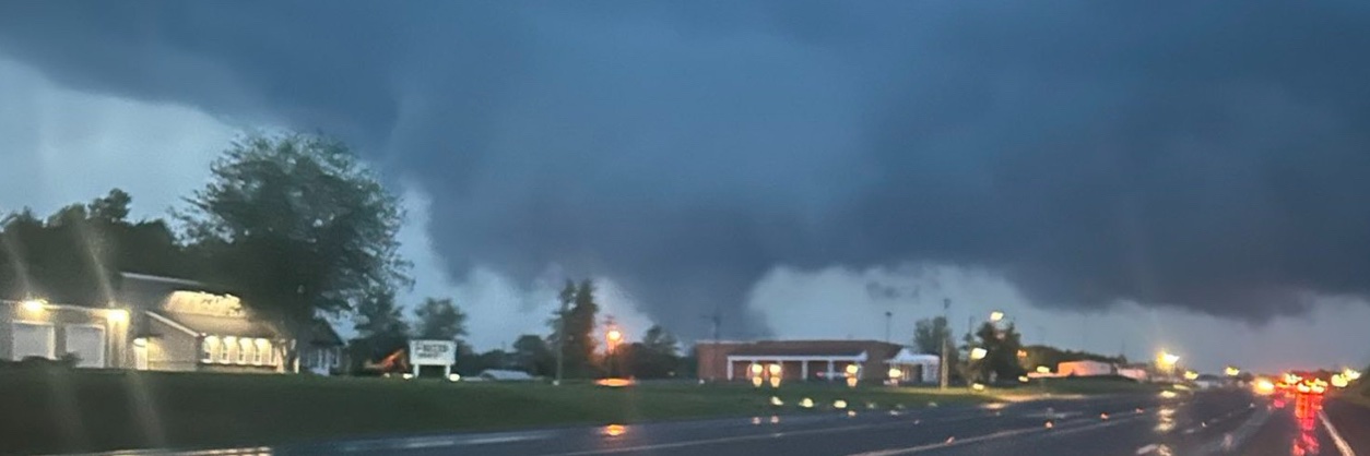
Caught this gorgeous canopy of eroding Mammatus clouds earlier tonight on my deck here in Bowling Green.
Anyone else caught these?
Made for a majestic of a sunset!
-Mike
A Tornado Warning on a bookend cell on the S side of Indy moving East toward Franklin and I-65. Small nudger with this one. If there is one, looks to be more of a Gustnado. This is radar indicated.
A WET DAY WE HAD…
Impressive radar estimates of rainfall we had across our Region today. From a complex of storms this morning dumping several inches in Isolated parts and then heavy showers in the Afternoon for Southern KY, a gullywasher of a day!
Just West of Louisville in Harrison Co, radar estimates of 6-7” was picked up. Taylor and Green counties picked up about 4-5” earlier this morning.
A few Isolated showers are possible through the evening but our airmass is quite saturated and worked over.
-Mike
An Isolated frog stranger has popped up drifting East over Hartford/Beaver Dam. I can see a few more of these showers popping up next couple hours as we still have plenty of moisture and energy out there to cause more heavy downpours until Sunset.
Time-lapse of the shelf cloud that moved through Bowling Green earlier today by our storm chaser @moebro7.
Nothing like seeing this on the of the hill⚡️ #KYwx
Flash Flood Warning for Logan, KY until 7:45 PM 6/9. Flash flooding from heavy thunderstorms is ongoing/expected; 1-3" rain with more possible. Turn around, don’t drown—avoid flooded roads, especially underpasses.
Flood Warning for Todd, KY until 6:30 PM 6/9. Flooding from excessive rainfall is imminent/occurring; rivers/creeks and low-lying areas may overflow. Turn around, don’t drown—avoid flooded roads and stay out of water.
Special Weather Statement for Monroe, Metcalfe, Cumberland until 5:00 PM 6/9. Wind gusts up to 40 mph may knock down limbs and blow unsecured items. Torrential rain may cause localized flooding. Avoid driving through flooded roads; seek shelter indoors.
4PM Central Update:
As Southern 1/2 of KY is getting rowdy with the ongoing storms, remember that airmass recovery is ongoing for the Northern 1/2 of KY and Southern IN. Some clearing is taking shape and still energy to monitor to spark more Showers and heavier storms along with the risk of flooding. Radar is clear and puffy Cumulus is draping over Indiana. Keep an eye out next several hours.
Special Weather Statement for Logan & Simpson until 4:45 PM 6/9. Wind gusts up to 50 mph and pea-size hail possible. Torrential rain may cause localized flooding. If outdoors, seek shelter indoors; don’t drive through flooded roads.
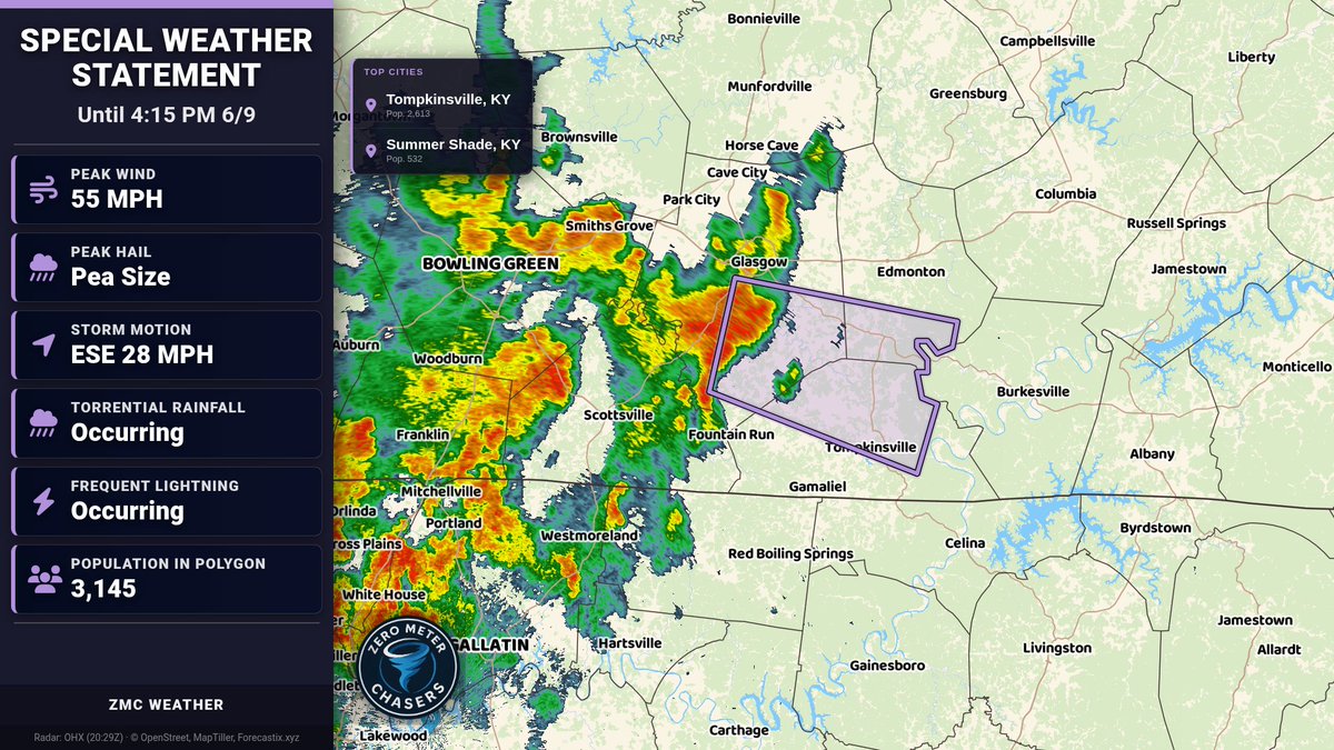
Special Weather Statement for Barren, Monroe, Metcalfe until 4:15 PM 6/9. Wind gusts 50-55 mph may knock down tree limbs and blow unsecured items. Torrential rain could cause localized flooding. Avoid driving through flooded roads; seek shelter indoors.
Special Weather Statement for Warren, Simpson, Allen, and Barren until 4:00 PM 6/9. Wind gusts up to 50 mph. Torrential rain may cause localized flooding; lightning. If outdoors, seek shelter inside; don’t drive through flooded roads.
HEADS UP for Southern KY & Middle TN:
Slow moving heavy showers continue to drop Southeast along & South of the Cumberland Parkway and US 68-80 corridor. PWat values over 2” in a moisture laden airmass will likely cause localized flash flooding with rainfall rates over 2”/HR at times. Rainfall amounts can be up to 3” in localized areas.
Please report if you see Flooding.