PSA 👋🏽, I am now on Bluesky (same handle) & hope to reconnect with many of you over there. My X account will still be maintained & running but I do hope to establish more posting overtime on Bluesky as the app upscales in UI. https://t.co/KeKc7wnPjW
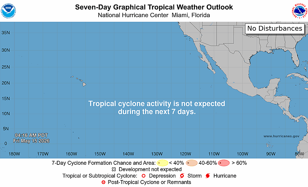
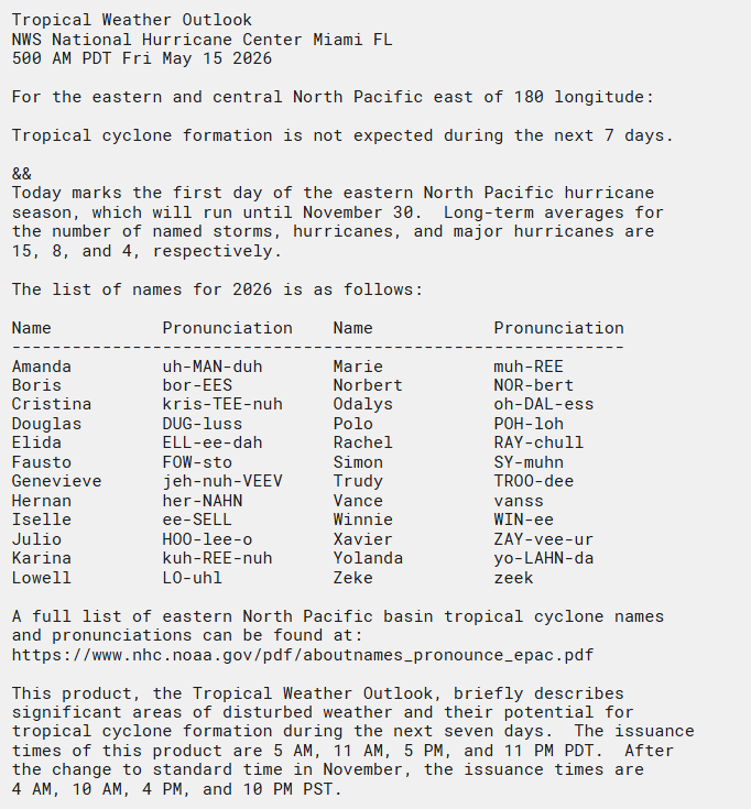
Today is the first day of the 2026 eastern Pacific hurricane season. The first Tropical Weather Outlook has been issued, and no tropical cyclones are expected over the next week.
More info: https://t.co/iYIpekul3Y
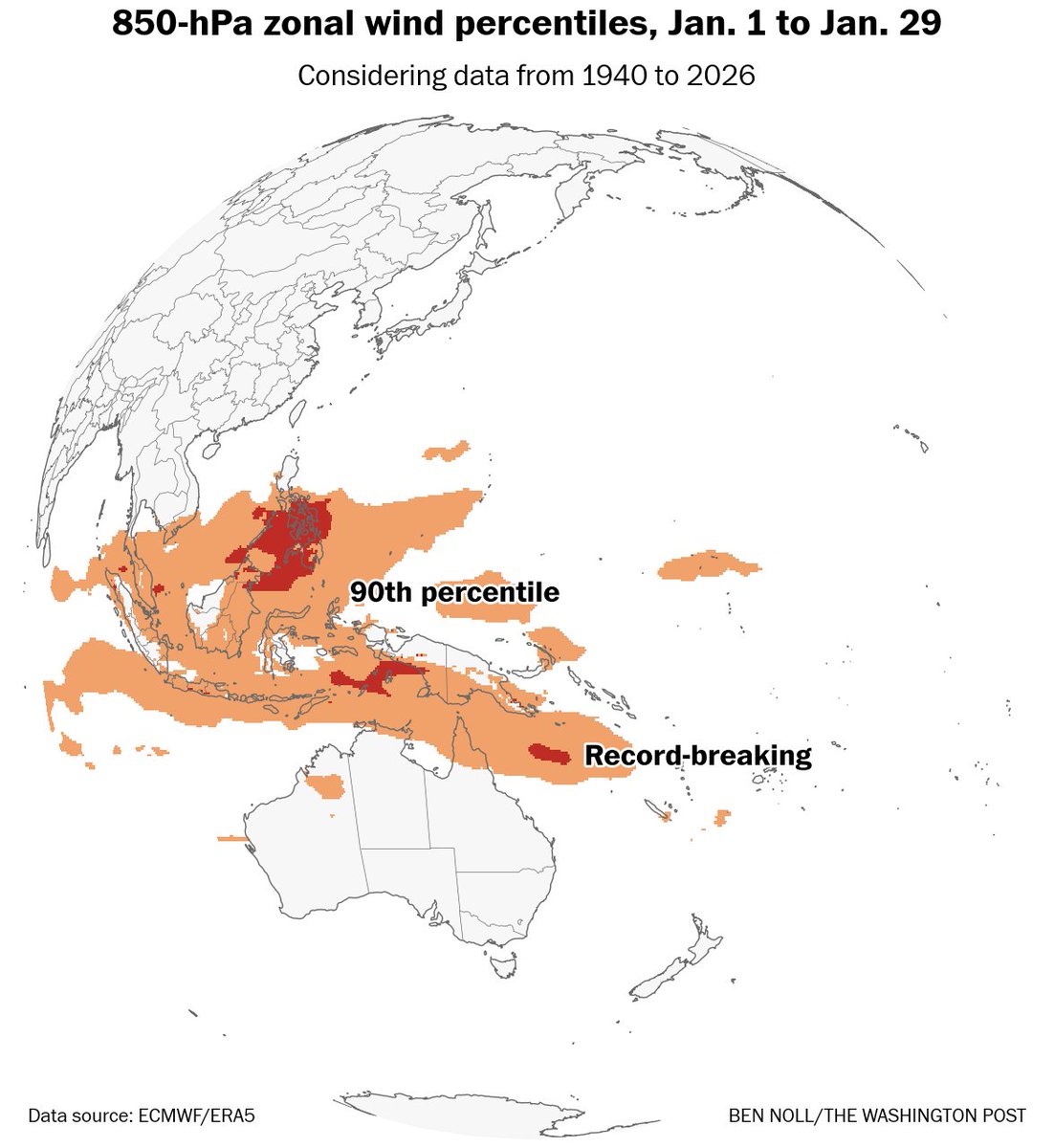
El Niño update: Westerly wind bursts during January were very unusual and record-breaking in some areas.
Warm water is now moving across the subsurface Pacific and will probably start to surface in February and March.
By mid-2026, ocean-atmosphere El Niño coupling is possible.
In case you missed it live, a full recording of my rapid-response livestream regarding news surrounding the proposed imminent and sudden dismantling of the National Center for Atmospheric Research (NCAR) is now available. https://t.co/NzpLIPcAYW
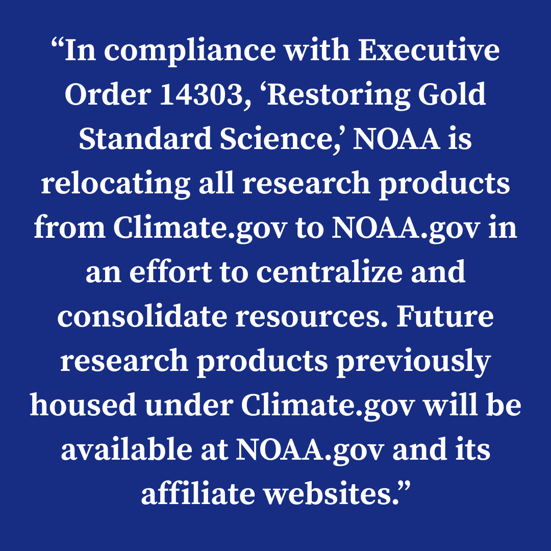
6-year later, now you know
Wreckage of NOAA and now NCAR can be directly traced back to career officials working with Obama administration (political) appointees / holdovers and the nascent Biden campaign (Ron Klain's wife) to create "Sharpiegate" through the Washington Post.
Those same career officials worked with outside groups like Union of Concerned Scientists to sabotage and smear everything related to Trump 45 weather and climate policy. It was standard operating procedure.
If you wanted "petty and vindictive" then you've got it. Also, look in the mirror. You could have chosen to work with Trump admin on weather/climate policy, meet half way, or contribute anything constructive. Instead, you chose "resistance" and conspiracy.
Hopefully what rises out of the ashes is considerably better than what is being burned down. 🔥
Unbelievable. This would be a terrible blow to American science, writ large. It would decimate not only climate research, but also the kind of weather, wildfire, & disaster research underpinning half a century of progress in prediction, early warning, & increased resilience.
EVACUATION WARNING FOR FRANKLIN & PALISADES BURN AREAS IN MALIBU DUE TO POTENTIAL FOR MUDSLIDES & DEBRIS FLOWS. FLOOD WATCH SAT, 4AM – 10PM.
The NWS increased its projected storm total of rain to 2-4 in, and issued a Flood Watch for Malibu, Sat, Nov. 15, 4AM - 10PM, with an increased threat of debris flows in the burn areas, roadway flooding and closures, overflowing rivers & creeks.
🚨 Evacuation Warnings are in effect for Palisades & Franklin burn areas (all of Zone Mal-C111 and Mal-C112) Thurs, 11/13, 6PM – Sun, 11/16, 11AM.
🌩️ Be prepared for mudslides, debris flows, rocks, and water on all roads, especially canyons. Only .5 in per hour can trigger debris flows.
⚠️Currently (10AM, 11/14), PCH & canyons are open, Topanga Cyn is closed.
⚠️ Be prepared for potential power/traffic signal outages. Come to a complete stop at any malfunctioning signal under CA law. Watch for workers and work vehicles.
⚠️Do not touch downed powerlines – stay back, warn others, and call 911.
⚠️Do not drive through moving water – turnaround, don’t drown!
💧 Monitor weather at https://t.co/Cn3qYpZKP7 and local news. Sign up for emergency alerts from the City at https://t.co/wPmfGKunKI & LA County at https://t.co/PsrJ2GIzDE
🚨Evacuation info and maps: https://t.co/raNb1Pu1vd
⚠️ Road closure info: https://t.co/YdzzyCyNlM
💙 Stay safe, Malibu!
Okay… I’ll step back out from under my rock for this one.
🫣
That is one wild run coming out of the European model suite tonight… Feast your eyes, but be wary of the modeling whiplash ahead.
00Z ECMWF deterministic model wants to drown Southern California. #CAwx
@heyhwsitgoing Yep, certainly a crazy deviation from the ensembles thus far & just when we thought models might start backing off from the crazier totals that the three storms already in the pipeline might bring by next Thursday, we get a hot potato like this…
@MichelBrewer You are indeed reading that right but take it with a grain of salt. This is only one model right now with this extreme of a scenario & most of the QPF is stacked from the first three storms already in the forecast through next Thursday. This latest model run upped it to 4 storms.
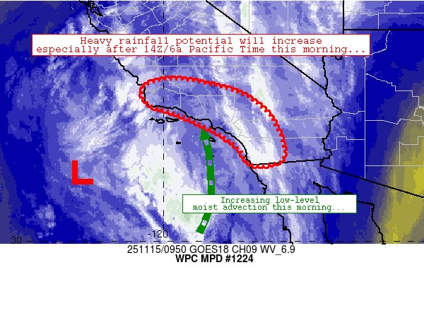
🌧️An atmospheric river will continue to impact California through late Saturday/early Sunday. Heavy rain will shift from Central CA today to Southern CA on Friday. Heavy precipitation may lead to scattered instances of flash flooding, especially near burn scars and steep terrain.
⚠️TSUNAMI WATCH in effect for the California coast. Estimated time of arrival as early as 12:15 AM on July 30. People along the coast: Stand by for further updates. #KnowYourZone at https://t.co/Dm0UehpMVM #CAwx#Tsunami
Updated estimated impact times for areas under a tsunami watch, California impacts would begin just before midnight for the NorCal coast and between 12am-1am for the Bay Area #CAwx 7/29/2025
A TSUNAMI WATCH IS NOW IN EFFECT for
coastal San Luis Obispo, Santa Barbara, Ventura, and Los Angeles Counties. An earthquake 8.7 80 miles southeast of Petropavlovsk Kamchatka, Russia. Stay tuned for updates.
https://t.co/t3G7WiWiRU
I'll offer an unplanned "pop-up" livestream to discuss the outbreak of widespread #thunderstorms across Southern California this afternoon. Expect a radar and satellite tour! (Yes, this is the second livestream of the day. See you at 4pm PT! #CAwx#LArain https://t.co/YVVQSEiOik