A Winter Storm WARNING has been issued for the entire area from 10 AM Friday til 7 AM Saturday.
Heavy snow is expected. Total snow accumulation of 3-6 inches is expected, with higher amounts possible.
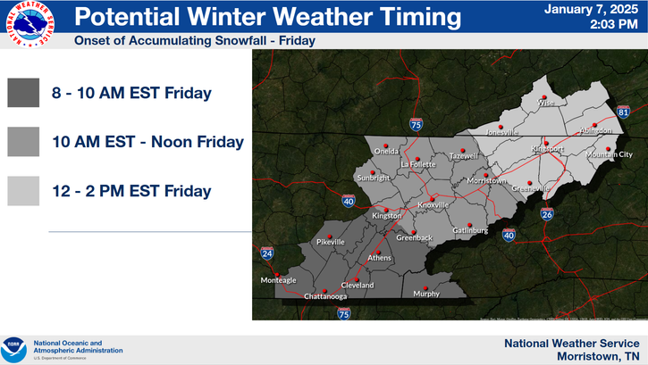
FIRST CALL: Snow Forecast (Friday Morning Through Saturday Morning)
An impactful winter storm is set to arrive Friday morning, with snow spreading northward from the lower valley into the Tri-Cities area by early/mid-afternoon. Travel conditions will deteriorate rapidly, becoming hazardous or even impossible in some areas during the Friday evening commute and much of Saturday. Non-essential travel is strongly discouraged.
Storm Timing (Friday)
Lower Valley: 8-10 AM
Mid-Valley: 10 AM - 12 PM
Upper Valley/SWVA: 12-2 PM
Forecast Snow Totals
Tri-Cities: 2-5" (Isolated 6")
Knoxville: 2-5" (Isolated 6-7")
Plateau: 2-5" (Isolated 6-7")
Smokies: 5-7" (Isolated 8-10")
NETN Mountains: 4-6" (Isolated 7-8")
SWVA Mountains: 4-5" (Isolated 6")
Action Steps
Prepare Now: Stock up on essentials to last a few days, including food, water, and medications.
Avoid Travel: Stay off the roads Friday evening and Saturday if possible.
If Travel Is Necessary: Pack an emergency kit with warm clothing, food, water, a flashlight, and other survival items in case you become stranded.
Stay tuned for updates as the forecast evolves
AMBER Alert for 2 y/o Elton Bailey, missing from Knoxville.
He last seen wearing a gray shirt & pants. He's 3', 35 lbs, w/blonde hair & blue eyes. He may be in a 2002 gold Ford Explorer, w/TN tag 859BBGN.
See him, contact the KPD at 865-215-7000 or TBI at 1-800-TBI-FIND.
We've teamed up with @FirstWarnTRI and @etnwxnetwork for the Appalachians Helene Relief Fundraiser. We are at over 2k raised for flood victims in northeast TN, Western NC, and Southwest VA. Let's get this to 3k by the end of the week!
https://t.co/CIV59Ab10J