The support and response I’ve received for the Weather Educational Series has been incredible. Thank you all for making it a success!
Based on your comments and questions, I’ll be bringing more educational posts to help provide better clarification and a deeper understanding of weather topics.
Your continued support means a lot. 🌦️📚
mega rain in last 24hrs at rain giants
Mawsynram: 526mm
Cherrapunji: 332mm
Can tamhini takeover these two places like last year... time will tell. #monsoon2026
The National Oceanic and Atmospheric Administration (NOAA) has confirmed the formation of a new El Niño in the equatorial Pacific.
📍What is the Super El Niño?
- Extreme warming of sea-surface temperatures (SSTs) in the central/eastern Pacific, exceeding 2°C above the long-term average — far beyond a standard El Niño.
📍How it forms:
> Trade winds weaken or reverse, allowing warm water to drift eastward toward South America
> A self-reinforcing feedback loop — warmer eastern Pacific further weakens winds, pushing temperatures past 2°C
> Climate change acts as a multiplier, raising baseline ocean heat and intensifying modern events
📍Key characteristics:
> Follows an S-curve lifecycle — emerges in spring, peaks in winter, collapses by next spring
> Monsoon suppression is felt mid-to-late season, not at onset
> Historically rare — only 4 super events since 1950: 1972–73, 1982–83, 1997–98, 2015–16
> Shifts cyclone patterns — suppresses Atlantic hurricanes, intensifies Pacific typhoons
📍Impact on India:
> Weakens the South Asian Monsoon → below-normal rainfall, drought risk
> Causes erratic rainfall, delayed onset, long dry spells → agricultural stress
> Positive IOD can partially offset effects, but relief is limited
📍Global impacts:
> Triggers forest fires, coral bleaching, ecosystem collapse
> Causes transnational droughts → food insecurity, water shortages
> Pushes global temperatures past the 1.5°C threshold by releasing stored ocean heat
मान्सूनच्या संदर्भात IOD म्हणजे काय?
काल परवा पासून IOD (Indian Ocean Dipole) हा शब्द वारंवार समोर येतो आहे. त्याचा मान्सूनवर काय परिणाम होणार ? तो अल निनोचा प्रभाव वाढवणार की कमी करणार? याबाबत चर्चा सुरू झाली आहे. त्यामुळे ही IOD म्हणजे नक्की काय भानगड आहे याबाबत लोकांमध्ये औत्सुक्य वाढले आहे.
IOD (Indian Ocean Dipole) म्हणजे हिंद महासागरातील द्विध्रुवीयता. हिंद महासागर हा विशाल असून तो इंडोनेशिया ऑस्ट्रेलिया पासून ते थेट आफ्रिकेपर्यंत पसरला आहे. हा एक हवामानविषयक प्रकार आहे ज्यामध्ये हिंद महासागराच्या पश्चिम भागातील आणि पूर्व भागातील समुद्रपृष्ठीय तापमानात फरक निर्माण होतो. हा फरक भारतीय मान्सूनवर महत्त्वाचा परिणाम करतो.
IOD चे प्रकार
१. सकारात्मक IOD (Positive IOD)
* आफ्रिकेजवळील पश्चिम हिंद महासागरातील पाणी नेहमीपेक्षा जास्त उष्ण होते.
* इंडोनेशिया-ऑस्ट्रेलियाजवळील पूर्व हिंद महासागरातील पाणी नेहमीपेक्षा थंड होते.
* त्यामुळे भारताकडे अधिक आर्द्रता (ओलावा) खेचली जाते.
* परिणामी भारतात सामान्यपेक्षा जास्त किंवा समाधानकारक पाऊस पडण्याची शक्यता वाढते.
२. नकारात्मक IOD (Negative IOD)
* पूर्व हिंद महासागरातील पाणी अधिक उष्ण होते.
* पश्चिम हिंद महासागरातील पाणी तुलनेने थंड होते.
* त्यामुळे आर्द्रता इंडोनेशिया व ऑस्ट्रेलियाकडे जास्त आकर्षित होते.
* भारतातील मान्सून कमकुवत पडू शकतो आणि पावसाचे प्रमाण कमी राहू शकते.
३. तटस्थ IOD (Neutral IOD)
* पश्चिम आणि पूर्व भागातील तापमानातील फरक सामान्य असतो.
* मान्सूनवर विशेष परिणाम होत नाही.
एल निनो आणि ला निनाशी संबंध
* एल निनो + सकारात्मक IOD : एल निनोमुळे मान्सून कमकुवत होण्याची शक्यता असली तरी सकारात्मक IOD त्याचा परिणाम काही प्रमाणात कमी करू शकतो.
* ला निना + सकारात्मक IOD : भारतात चांगल्या किंवा अतिचांगल्या पावसाची शक्यता वाढते.
* एल निनो + नकारात्मक IOD : दुष्काळ किंवा कमी पावसाचा धोका वाढू शकतो.
सोप्या भाषेत
हिंद महासागराच्या पश्चिम भागातील पाणी जास्त उष्ण झाले (सकारात्मक IOD) की भारताकडे येणाऱ्या मान्सून वाऱ्यांना अधिक बळ मिळते आणि पाऊस वाढतो. उलट पूर्व भाग जास्त उष्ण झाला (नकारात्मक IOD) तर आर्द्रता भारताऐवजी इंडोनेशिया-ऑस्ट्रेलियाकडे वळते आणि भारतात पाऊस कमी पडू शकतो.
म्हणूनच IOD हा भारतीय मान्सूनचा एक महत्त्वाचा नियंत्रक घटक मानला जातो, जसा एल निनो आणि ला निना मानले जातात.
डॉ प्रशांत भामरे.
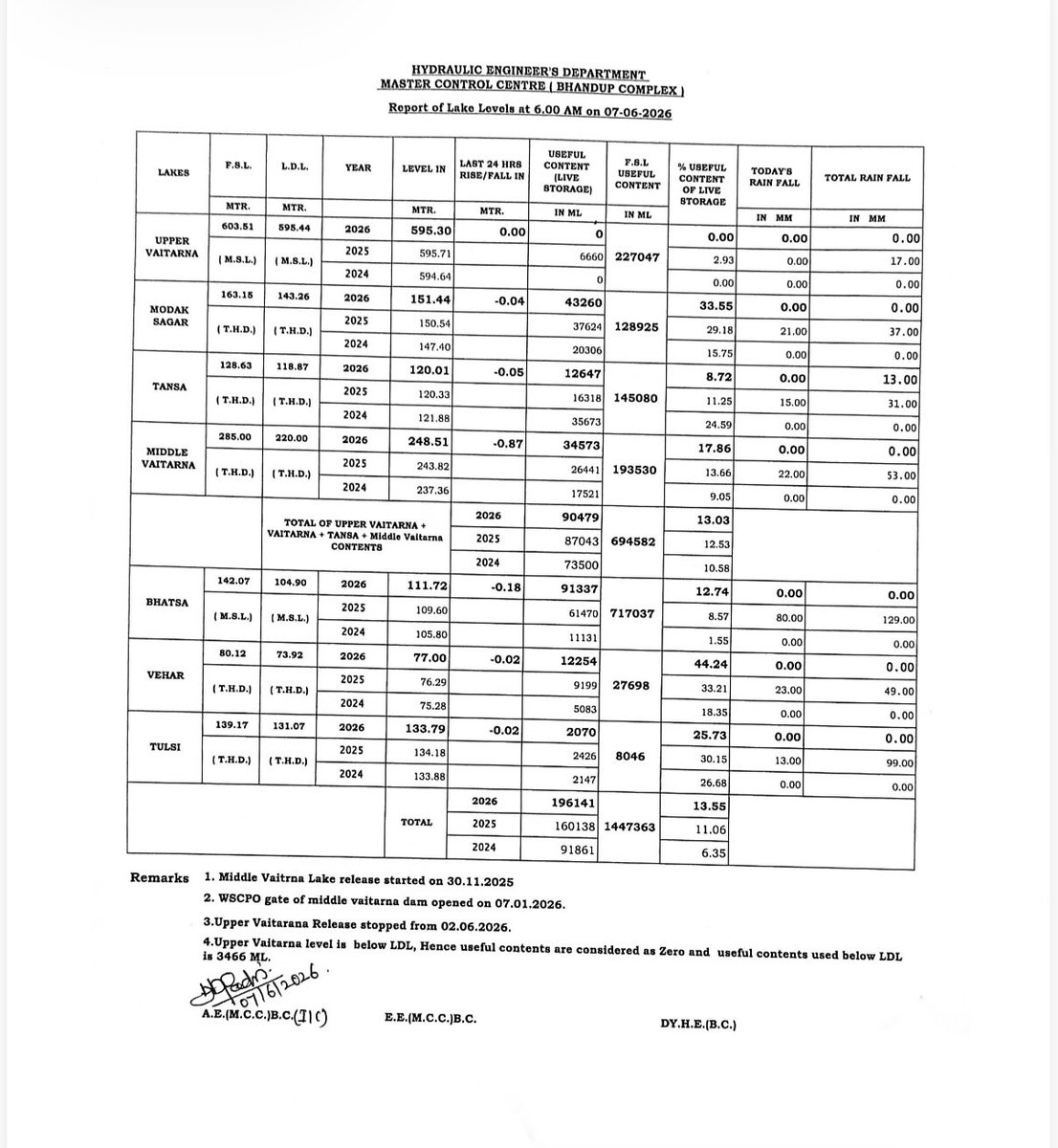
Water stocks in lakes supplying to Mumbai at 13.55%.
Please use water judiciously. With heavy rainfall unlikely over Mumbai and adjoining areas in the immediate future, conserving every drop is crucial.
While the normal onset date of the monsoon over Mumbai is June 11, current weather patterns do not indicate a strong start to the season.
Year 2015
A markedly #deficient_monsoon across much of India & only W Rajasthan excess rains.
All-India seasonal RF (June–Sept 2015) was 86% of LPA making 2015 one of major drought monsoon yrs of recent decades.
Pl chk onset dates too.
Marathwada: -40%,
Madhya Mah: -33% deficient
IMD has failed for the 2nd Time in History regarding the dates of Monsoon Onset over Kerala (2015 & 2026)
(Interesting to note that 2015 & 2026 is a Super El Niño Years)
(MONSOON FORECAST)
Kerala : June 04 (±1 day)
Telangana : June 07 to June 11
⚠️ Image Credits : IMD
Global atmospheric concentrations of greenhouse gases carbon dioxide (CO₂) and methane (CH₄) continued to increase in 2025, reaching their highest annual values in the satellite record. Since 2020, CO₂ concentration has risen by ~2.6 ppm/yr & CH₄ by~11.6 ppb/yr.
#ESOTC2025 ⬇️
Water scarcity has long been one of India’s greatest vulnerabilities, and the warning signs are flashing again.
The India Meteorological Department (IMD) has cautioned about the possibility of drought-like conditions this year, with seasonal rainfall projected at just 90% of the long-period average. More worrying is the 60% probability of deficient rainfall — less than 90% of normal — raising concerns over crop losses, shrinking reservoir levels and potential water shortages in several regions.
As we await the monsoon, this is a reminder that every drop counts. Use water responsibly, avoid wastage, and make conservation a daily habit. What seems abundant today could become scarce tomorrow.
IMD releases Updated Long Range Forecast for the Southwest Monsoon Seasonal Rainfall
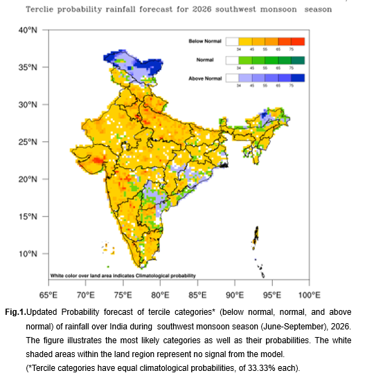
a) The southwest monsoon seasonal rainfall over country as a whole is likely to be 90% of Long Period Average (LPA) with a model error of ±4%, indicating that below normal rainfall over the country as a whole during the monsoon season (June to September), 2026.
b) Southwest monsoon seasonal (June to September, 2026) rainfall is most likely to be normal over Northeast India (94-106% of LPA) and below normal over Central & South Peninsular India (<94% of LPA) and Northwest India (<92% of LPA).
c) The southwest monsoon seasonal rainfall over Monsoon Core Zone (MCZ) is most likely to be below normal (<94% of LPA).
d) During June to September 2026, below-normal seasonal rainfall is most likely over most parts of the country, except some areas over Northwest and northeast India, eastern parts of south peninsula and adjoining areas of east-central India and isolated pockets of East India, where normal to above normal rainfall is likely.
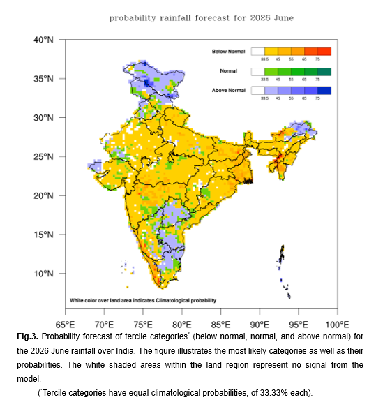
e) Average rainfall for country as a whole during June 2026 is most likely to be below normal (<92% of LPA).
f) During June 2026, below normal monthly rainfall is very likely over most parts of the country, except over some parts of NorthwestIndia, Northeast India and south Peninsula and isolated pockets of central India where normal to above normal rainfall is likely.
g) In June 2026, above normal monthly maximum temperatures are likely over most parts of the country, except some parts of Central, Northwest and East India, where normal to below normal maximum temperatures are very likely. Above-normal monthly minimum temperatures are likely across most parts of the country, except some parts of Northwest, Central and adjoining south Peninsular India where, where normal to below-normal minimum temperatures are very likely.
For more details, visit: https://t.co/z1mAtFryoJ
Youtube link of Press Conference : https://t.co/kfZE29CtDw
#Monsoon2026 #WeatherForecast #LongRangeForecast #WeatherUpdate #RainySeason2026
@PMOIndia@moesgoi@Ravi_MoES@DrJitendraSingh@ndmaindia@airnewsalerts@DDNewslive@PIB_India@mygovindia@NDRFHQ@icarindia
Given the unbearable heat in North India, it would be useful to listen to this podcast with DG IMD, Dr Mohapatra.
El Nino is going to heat us up towards the 2nd half or end of this monsoon. Here is a deep dive into all the factors that could mitigate or exacerbate that effect
The IOD, WD, Eurasian snowcover, Typhoon remnants, Tibetan High, Somali Jet, etc.
Then he explains climate change and the role of the sea as a sink and its limits.
He ends Part 1 with simple math on how much damage we do by burning one 100W bulb for 24 hrs.
https://t.co/DkQKPnJ0OJ
@PPFNewDelhi
The Coriolis Effect is the reason motion on Earth never stays perfectly straight. As the planet rotates, winds bend, ocean currents curve, and massive storms begin to spin across the surface.
F = −2m(ω × v)
• Northern Hemisphere → deflects right
• Southern Hemisphere → deflects left
• One of the invisible forces behind global weather patterns.
VIDEO | Mumbai, Maharashtra: IMD Mumbai Scientist ‘E’ Sushma Nair said hot and humid weather conditions are prevailing in the Mumbai region and pre-monsoon activity is likely to begin soon. She also shared details regarding heatwave warnings issued for parts of the region.