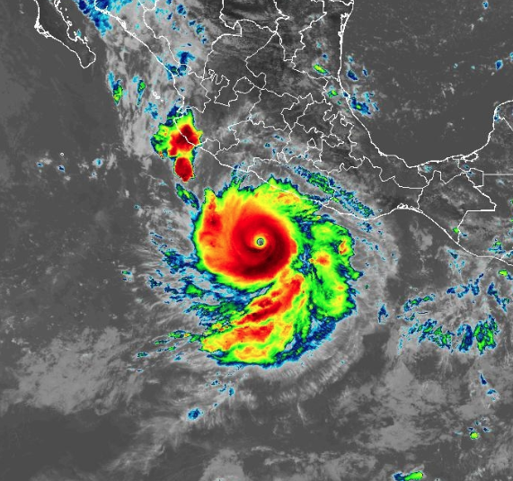
Hurricane Polo has strengthened even more!
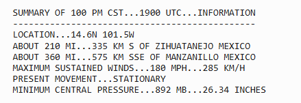
NOAA Hurricane Hunters found 180 mph winds and a pressure of 892 mb, the second-lowest on record in the Eastern Pacific 🌀
9/22 1pm CST: NOAA Hurricane Hunters have found that Category 5 Hurricane #Polo, located offshore of #Mexico, has strengthened to a 180 mph hurricane
See https://t.co/NyUGSIFCuo for the latest forecast.
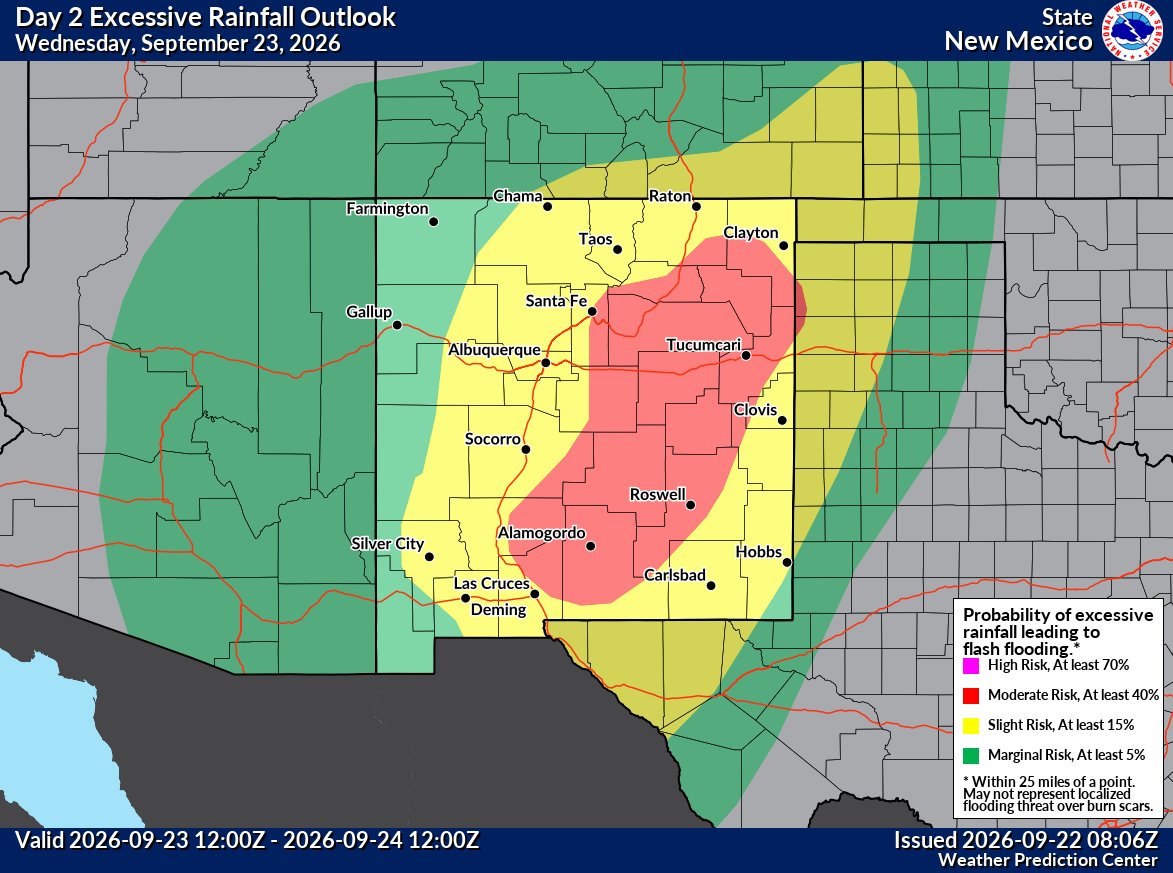
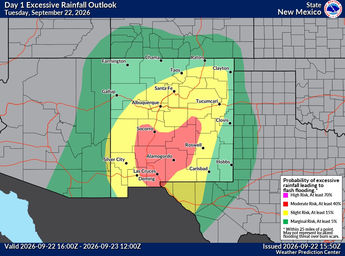
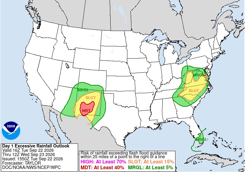
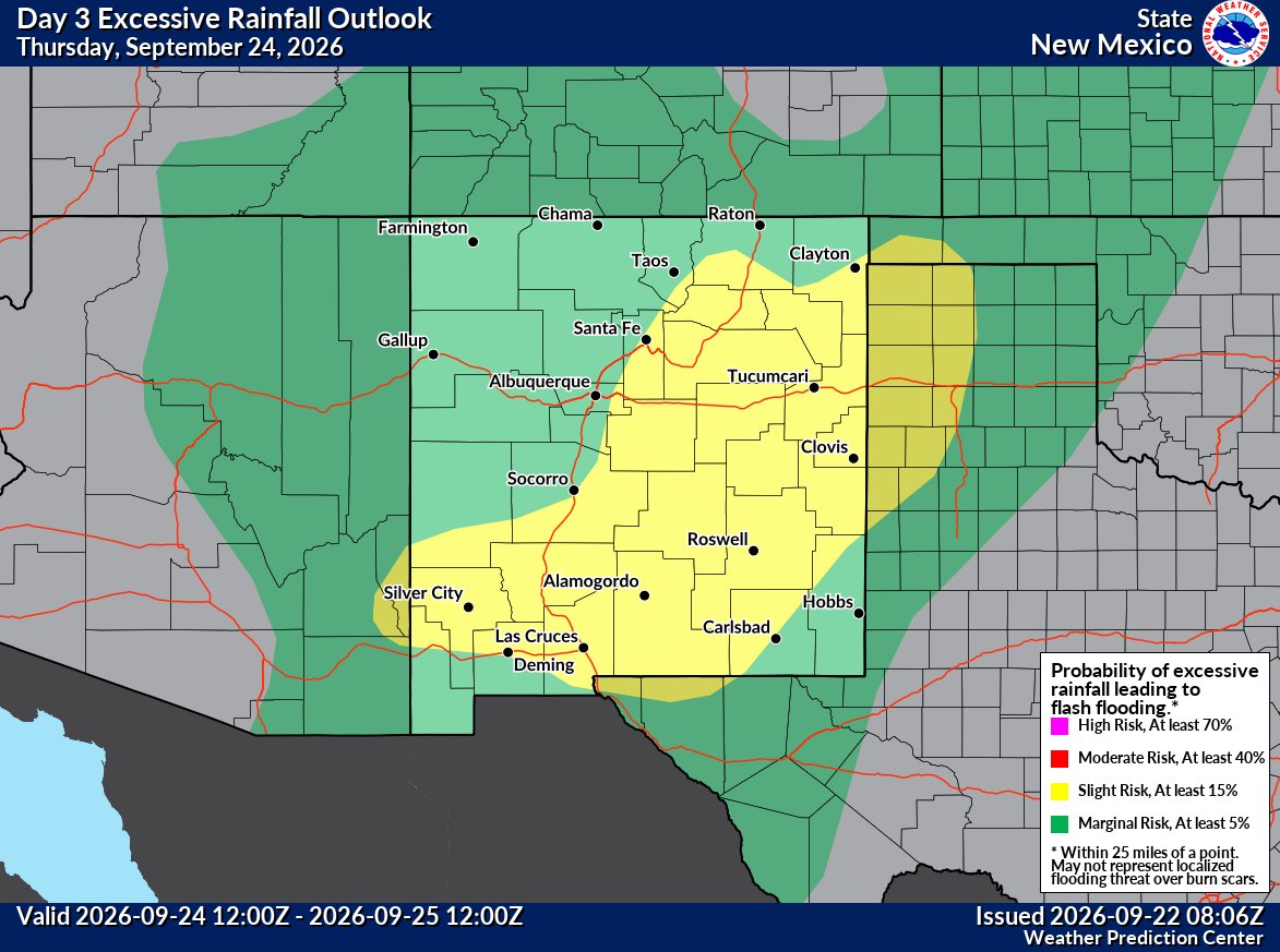
⚠️ A high flash flooding threat will continue across New Mexico through Thursday.
A Moderate Risk is in place across southern NM today, then shifts and expands across central and eastern NM Wednesday.
With very wet ground, it may not take much rain to cause flooding. 🌧#NMwx
Another big rainfall event starts today across New Mexico!
Widespread heavy rain continues through early Thursday. Many areas could see 1-3", with 3-4"+ possible east and south.
The flooding threat is serious, especially with saturated ground.
#NMwx
BREAKING: Category 5 monster Hurricane Polo now has eyewall winds up to 180 mph!
The storm is now the second most-intense eastern Pacific hurricane on record…
…AND strengthened 110 mph in 24 hours (second most on record).
@MatthewCappucci’s metnote: https://t.co/jG4JbRKJI2
.@ASU climate expert Randy Cerveny tells me that right now Hurricane Polo off the west coast of Mexico is roughly the same size but slightly weaker than the western hemisphere record west coast Hurricane Patricia in 2015 (which was also an El Nino year). Wow.
Polo is a Category 5 monster. It’s the second fastest-intensifying eastern Pacific storm on record.
It now has 160-180 mph winds. But could its moisture later affect the Desert Southwest?
Senior meteorologist @MatthewCappucci has an update.
BREAKING: Hurricane Polo is now the second strongest hurricane EVER recorded in the eastern Pacific!
It's air pressure is BELOW 890 MILLIBARS! That's virtually unheard of!
At flight level, the eye is about 29 degrees warmer than the surrounding atmosphere. Tropical cyclones are "warm core" systems. That heating from the oceans below causes warm air to rise, lifting air away from the surface and leaving a "void", or deficit, of air.
It has lifted 565.3 BILLION pounds of air, or about HALF A TRILLION POUNDS! That's the equivalent to 47 Great Pyramids of Giza!
That "missing" air creates a vacuum of sorts. That's why hurricanes have powerful inward suction, resulting in extreme winds.
When we talk about air pressure, we're talking about how much air there is! In this case, 12.2% of the air is missing from the middle! That's incredible!
Much of New Mexico is bracing for impact as meteorologists warn of possible life-threatening flash flooding this week. A flood watch for many areas is set to go into effect Tuesday, setting the stage for several days of moderate to heavy rainfall. https://t.co/poACUWx8CZ
⚠️ Nearly all of New Mexico is under a Flood Watch through early Thursday.
A major surge of monsoon moisture will bring widespread heavy rain today and Wednesday. Many areas could see 1–2"+, with locally 4"+ possible.
Flash flooding could develop quickly. #NMwx
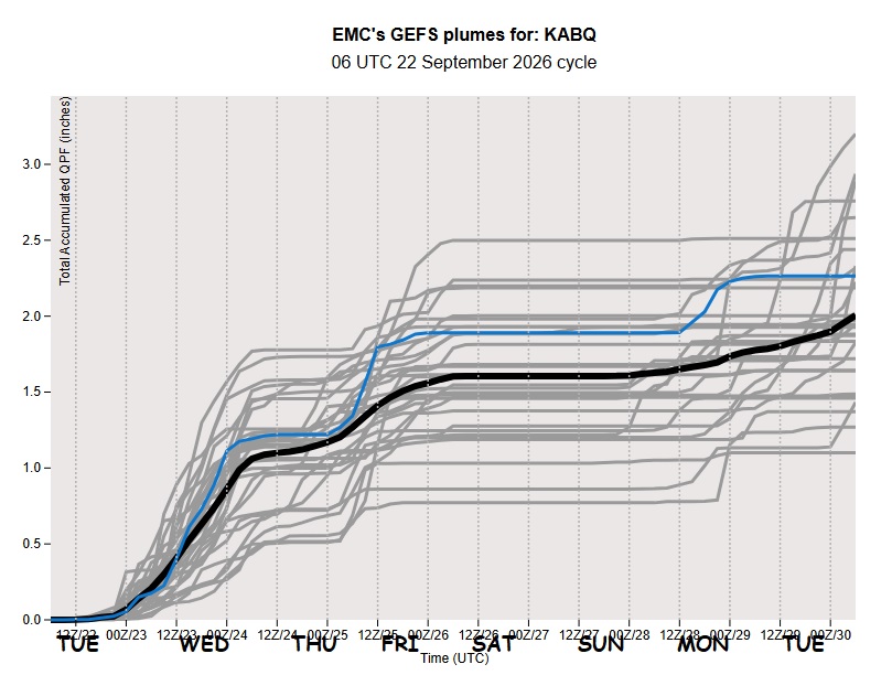
Polo's stream of tropical moisture is poised to hit NM, possibly E AZ, next 48-72hrs. Note sat loop stream of moisture from Polo into N MX. Model QPFS are targeting NM/ABQ for flooding precip dump not PHX. Depending on Hurricane Polo's motion that stream could re-directed. #azwx
Wow. Hurricane #Polo looks spectacular from satellite this morning 🌀
It’s a category 5 beast with winds of 260 km/h (160 mph), and still intensifying. Luckily, it is still forecast to turn away from landfalling over Mexico.
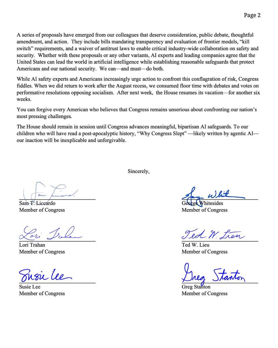
We're urging @SpeakerJohnson to call the House back into session so we can pass AI safety legislation and put real guardrails in place.
There is too much at stake.
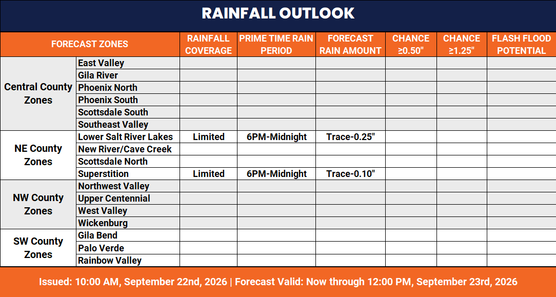
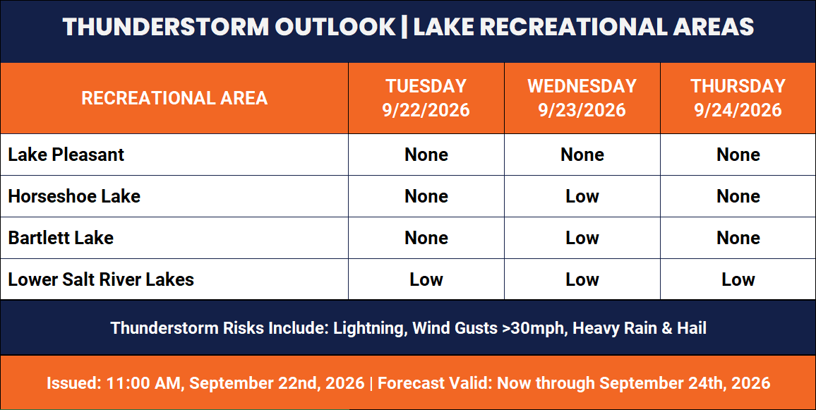
We're monitoring a more active weather pattern this week: slim possibility of rain today, better chances tomorrow 🌧️👀 Highs linger around seasonal normals (low 90s/upper 100s) #azwx
Full Outlook 👉 https://t.co/QHKPlzv0Aq
Extreme LIGHTNING activity in the core of Hurricane Polo! When you see a storm with the EEL, or "Enveloped Eyewall Lightning", it's a sign a storm may still be intensifying.
The maximum winds peak AFTER the lightning activity peaks about 70% of the time.
That means Polo probably isn't quite done intensifying, and may continue well above the threshold for Category 5 strength. It's already the second fastest-intensifying eastern Pacific storm on record.
Tropical cyclones typically don't produce much lightning toward the innards of the storm in the CDO, or Central Dense Overcast, region. Lightning is most commonly relegated to the spiral rain bands on the periphery of the storm. That's because most of the air in a hurricane is swirling primarily horizontally rather than upwards, and strong updrafts (upward motion) is required for charge separation and lightning. When you have lightning in the eyewall, it's a symptom of robust updrafts.
Polo is an absolute monster.
Yesterday, @NOAA's #GOESWest (#GOES18) 🛰️ captured Tropical Storm #Polo rapidly intensifying into a #hurricane off the southwestern coast of Mexico in less than 24 hours. #HurricanePolo is now a Category 5 storm with sustained winds of 160 mph.
Latest updates and advisories: https://t.co/g8o6QiSK83