Fire Information -- June 15, 2026
Arizona — Rock Canyon Fire & Dellenbaugh Fire
Wildland firefighters from the @USWFS, USFS, and local area fire departments are working to actively suppress 2 wildland fires in northwest Arizona.
Rock Canyon
36° 54.94’ x 112° 12.19’
Lightning caused
500 acres + estimated
Location: 9 miles south of HWY 89, 9 miles west of House Rock Valley Rd
Fire Behavior: Extreme fire behavior with running, torching and spotting.
Approx. 50 personnel on scene from USWFS, USFS, NPS. Additional resources on order.
Dellenbaugh Fire
36° 04.50' x 113° 32.12'
Lightning caused
400 acres + estimated
Location: NPS [Grand Canyon-Parashant National Monument] south of Mount Dellenbaugh
Structures threatened 2 miles to the north, 2 miles to the northeast
Fire Behavior: Extreme fire behavior with running, torching, and spotting
16 personnel on scene from USWFS. Additional resources on order
To protect Arizona's landscapes and communities, the board approved a Regents’ Grant focused on reducing wildfire risk in the Sonoran Desert.
In partnership with @azstateforestry,@ASU, @NAU and @UArizona researchers will develop and evaluate wildfire mitigation techniques.
The tri-university effort aims to close key data gaps and strengthen on-the-ground decision making for land managers and fire officials: https://t.co/KKy4tMGPJI
Buck Fire Update for Sun. 6/14:
Fire mapped at 40 ac. & 90% contained. No new growth overnight or throughout the day today. Increase in acreage due to more accurate mapping.
Helo used again Sunday to support ground resources by providing bucket work to cool hot spots along the fire's edge. Two engines & Arizona Forestry hand crew remain assigned to the incident. For Monday, resources will continue with mop up to ensure no heat remains.
🔥This will be the final update on this incident unless there's a significant change in fire activity.
📍Fire started Sat. 6/13, approx. 20 mil. SW of Seligman near Double O Ranch & Buck Tanks.
#AZFire #AZForestry
📷: Buck Fire perimeter
#BuckFire, est. 10 ac. w/forward progress stopped.
Fire activity has moderated & resources focused on securing the edge. Arizona Forestry hand crew & BLM engine remain assigned.
The fire started Sat. afternoon approx. 20 mi. SW of Seligman near the Double O Ranch & Buck Tanks.
#AZFire #AZForestry
Forward progress stopped on #BuckFire SW of Seligman near the Double O Ranch.
Fire activity has moderated & resources cont. w/full suppression efforts.
#AZFire#AZForestry
Arizona Forestry working #BuckFire approx. 5-10 acres & actively burning thru grass & brush, SW of Seligman.
Winds are starting to pick up & increasing fire activity. Engines and helo currently assigned. Arizona Forestry hand crew en route w/ add'l resources on order.
📍Fire loc. est. 30 miles SW of Seligman, near Buck Tanks.
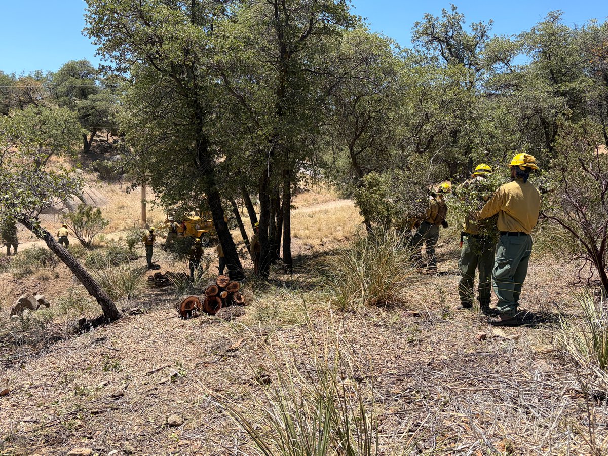
20 acres of good project work being done to support Oracle.
Arizona Forestry's Florence Crew has been working around the 2025 Cody Fire burn scar reducing hazardous veg - fuel for wildfires to expand defensible space efforts to further protect nearby residents.
Another example of our 'people first' mission & proactive work being done to support Arizonans.
#AZFire #AZForestry #PinalCounty
Pioneer Fire Update for Wed. 6/10:
90% contained w/no change in acreage: 10ac. Resources have spent the last few days cold trailing along the fire's edge checking for lingering heat as they work toward full suppression. Ops reported no visible smokes over the last 24 hours.
#PioneerFire started Sun. 6/7, south of Jake's Corner & north of Tonto Basin. Fire result of equipment usage.
✅Final update unless there's a significant change in fire activity.
#AZFire #AZForestry #GilaCounty
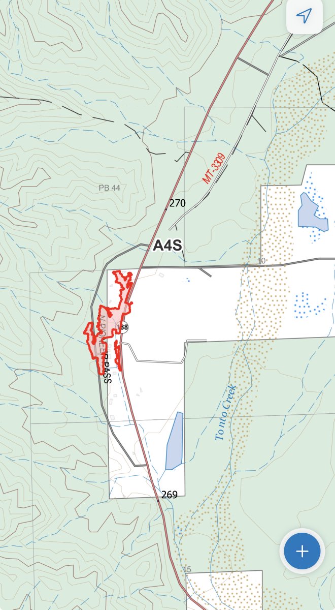
📷Pioneer Fire perimeter
Pioneer Fire Update for Mon. 6/8:
Resources have the fire 75% contained at 10 ac. The decrease in acreage is due to more accurate mapping. Crews remain focused on mop up operations to suppress some heat pockets along the fire's edge. Ops reports no visible smokes showing.
One hand crew, an engine & water tender remain assigned to the incident. All other resources have been released back to their home units.
The human-caused fire started Sunday, south of Jake's Corner and north of Tonto Basin. Four secondary structures, an RV & two RV trailers were destroyed in the fire.
SR 188 is open in both directions.
#AZFire #AZForestry #GilaCounty
📷: Pioneer Fire perimeter map
The #PioneerFire is 25% contained at an estimated 25 acres.
The fire continues to smolder through grass & brush west of SR 188, south of Jake’s Corner.
12 engines, 3 water tenders & a T2IA crew remain assigned. A second T2 crew is on order for the morning. All aviation assets have been released.
A few secondary structures were destroyed in the fire.
It was determined to be human-caused: equipment usage.
Per Gila County EM, SET remains in place for the Brownsville Mobile Home Park.
SR 188 is partially reopened. For traffic updates - https://t.co/93dPNUXBYP.
#AZFire #AZForestry #Gila
UPDATE: The eastbound right lane of SR 188 has reopened at milepost 270.
The eastbound left and westbound lanes remain closed. There is no estimated time to fully reopen the highway.
🚨Reminder - Red Flag conditions have settled in across northern Arizona today - Tuesday, June 9.
Avoid burning or using tools that spark. Secure trailer chains and never pull your vehicle off the road into tall vegetation.
Red Flag Warnings mean high fire danger due to high winds & low relative humidities.
🚫Stage 1 & Stage 2 fire restrictions in effect for most of AZ. For more info: https://t.co/VpPh8Ah6AS.
#AZFire #AZForestry #azwx
Windy and dry weather will persist Monday and Tuesday with additional critical fire weather, especially from the Mogollon Rim and White Mountains northward. #azwx
*CLOSURE*
SR 188 is closed in both directions at MP 270 due to a brush fire.
There is no estimated reopening time.
For real-time traffic info, check https://t.co/l4s0AFGOpz and the AZ511 app:
📱 Apple: https://t.co/YMcnUEeWQs
📱 Android: https://t.co/9oINS4ymQP
Update to #PioneerFire - forward progress stopped at est. 25 acres.
LATs have been released, but helo & ground resources cont. toward full suppression.
SR 188 remains closed near the fire loc. approx. 4mi. south of Jakes Corner & north of Tonto Basin.
Fire investigator ordered.
#AZFire #AZForestry #GilaCounty
Arizona Forestry responding to new start - #PioneerFire, approx. 4 mi. south of Jakes Corner & north of Tonto Basin.
Fire is est. 15 ac. with multiple resources on order incl. 2 Large Air Tankers (LATs), helo, T1 & T2IA crews.
Per https://t.co/93dPNUXBYP: Road closed due to fire on SR-188 Eastbound near N Pioneer Pass (MP 270). For real time traffic information, check https://t.co/93dPNUXBYP
📍Map location approximate
#AZFire #AZForestry #GilaCounty @ArizonaDOT
🚩🚨The NWS has issued Red Flag Warnings for much of Arizona through the weekend.
Hot & dry conditions coupled with high winds & low RH create critical fire conditions.
Don't burn or use tools that spark. Secure trailer chains & never pull off the road into tall vegetation.
Fire restrictions in place across most of the state: https://t.co/VpPh8Ah6AS.
#AZFire #AZForestry
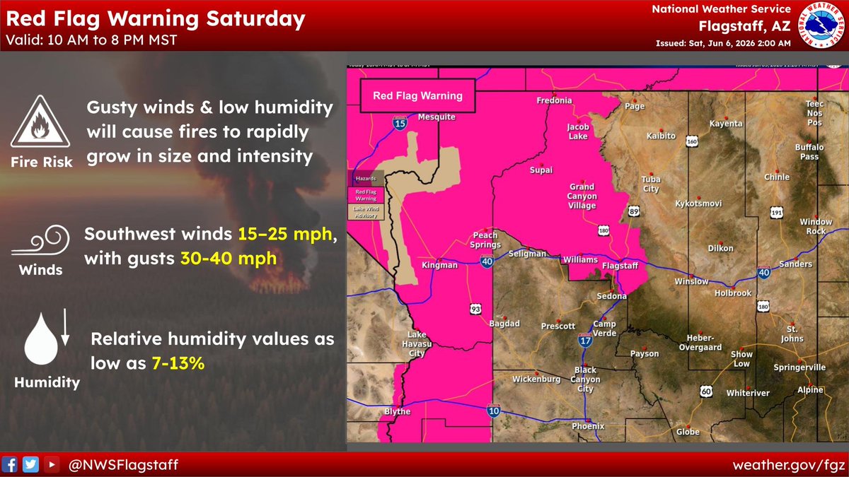
Red Flag Warnings and Fire Weather Watches have been issued for the weekend and into early next week. The western Mogollon Rim including the Flagstaff and Williams area was added to today's Red Flag Warning. Avoid burning, fires can spark and grow very quickly.
A Red Flag Warning is in effect from late Saturday morning through Saturday evening across southwest AZ & the Lower CO River Valley areas. The combination of very low RHs, dry fuels, & peak wind gusts upwards of 35 mph will result in critical fire weather conditions. #azwx#cawx
Work begins next week on an 1100 acre fuels reduction project south of Prescott. 🌲
Over the next few months, machinery and hand crews will work to remove hazardous fuel loads and compliment completed work on the Prescott National Forest, reducing the risk of catastrophic wildfire.
The Badger and Turley trails will remain open, but recreationalist should exercise caution throughout the area.
For more information ➡️➡️ https://t.co/NhHs7qIJUq
#AZFire #AZForestry #FuelsReduction

![BLMArizona's tweet photo. Fire Information -- June 15, 2026
Arizona — Rock Canyon Fire & Dellenbaugh Fire
Wildland firefighters from the @USWFS, USFS, and local area fire departments are working to actively suppress 2 wildland fires in northwest Arizona.
Rock Canyon
36° 54.94’ x 112° 12.19’
Lightning caused
500 acres + estimated
Location: 9 miles south of HWY 89, 9 miles west of House Rock Valley Rd
Fire Behavior: Extreme fire behavior with running, torching and spotting.
Approx. 50 personnel on scene from USWFS, USFS, NPS. Additional resources on order.
Dellenbaugh Fire
36° 04.50' x 113° 32.12'
Lightning caused
400 acres + estimated
Location: NPS [Grand Canyon-Parashant National Monument] south of Mount Dellenbaugh
Structures threatened 2 miles to the north, 2 miles to the northeast
Fire Behavior: Extreme fire behavior with running, torching, and spotting
16 personnel on scene from USWFS. Additional resources on order](https://pbs.twimg.com/media/HK5mrS4XQAAc4uX.png)


![BLMArizona's tweet photo. Fire Information -- June 15, 2026
Arizona — Rock Canyon Fire & Dellenbaugh Fire
Wildland firefighters from the @USWFS, USFS, and local area fire departments are working to actively suppress 2 wildland fires in northwest Arizona.
Rock Canyon
36° 54.94’ x 112° 12.19’
Lightning caused
500 acres + estimated
Location: 9 miles south of HWY 89, 9 miles west of House Rock Valley Rd
Fire Behavior: Extreme fire behavior with running, torching and spotting.
Approx. 50 personnel on scene from USWFS, USFS, NPS. Additional resources on order.
Dellenbaugh Fire
36° 04.50' x 113° 32.12'
Lightning caused
400 acres + estimated
Location: NPS [Grand Canyon-Parashant National Monument] south of Mount Dellenbaugh
Structures threatened 2 miles to the north, 2 miles to the northeast
Fire Behavior: Extreme fire behavior with running, torching, and spotting
16 personnel on scene from USWFS. Additional resources on order](https://pbs.twimg.com/media/HK5mrUQWsAAVZNF.jpg)