Thursday is expected to bring the same conditions to the area. There will likely be a risk for some strong to severe thunderstorms during the afternoon and evening hours.
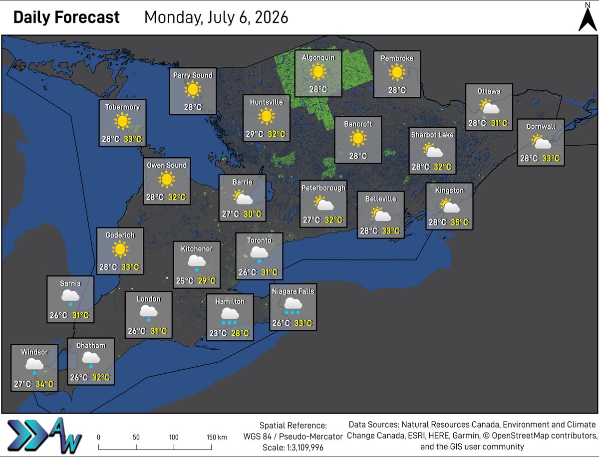
Temperatures in yellow represent forecasted Humidex values.
Wednesday is expected to bring mainly sunny skies to the region, with a small chance of a shower over any area.
It will be slightly warmer and slightly more humid tomorrow, with nearly all areas in the low 30s. Humidex values will be in the upper 30s.
The higher the UV Index, the stronger the sun's rays, meaning you need to take more precautions to protect your skin. The sun is at it's peak between 10 AM and 4 PM. Ensure you wear sunscreen and cover up with a hat and sunglasses.
**Very High UV Index Tuesday**
With sun and clouds forecasted across the region for Tuesday, all areas will be in the Very High category for UV Index. The highest UV Index will be 9.
Tuesday will bring sun and clouds to portions of Eastern Ontario, Midwestern and Southwestern Ontario, and the GTHA. Mainly sunny skies are expected in Central and Eastern Ontario.
There will be a low chance for showers to pop up in Central Ontario during the afternoon hours tomorrow with some torrential downpours possible.
Wednesday and Thursday will be slightly more humid. There will likely be a chance of thunderstorms Thursday afternoon and evening.
The higher the UV Index, the stronger the sun's rays, meaning you need to take more precautions to protect your skin. The sun is at it's peak between 10 AM and 4 PM. Ensure you wear sunscreen and cover up with a hat and sunglasses.
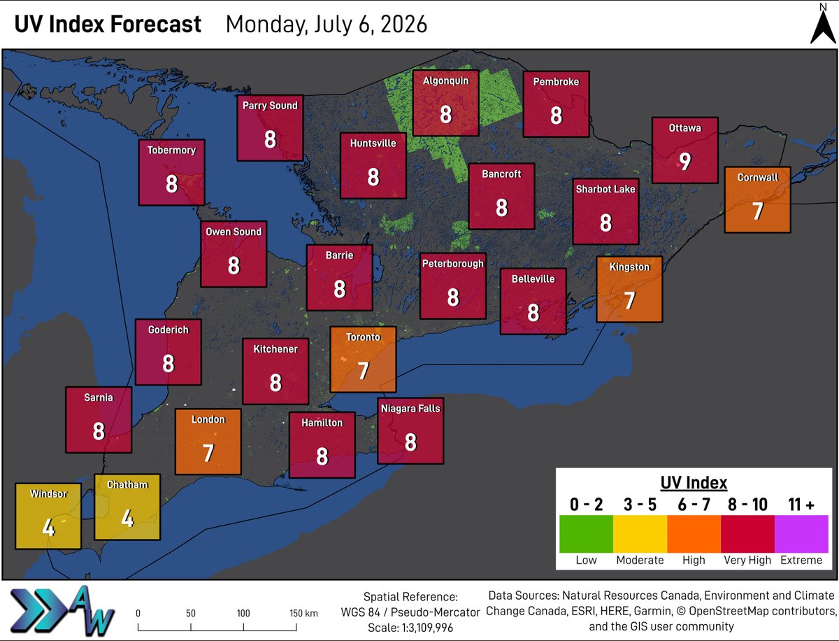
**Very High UV Index Monday**
Many areas are forecasted to see UV Index in the Very High category on Monday. The highest UV Index will be in Ottawa, forecasted to be at 9.
Radar is estimating over 4 inches (101 millimetres) of rain has fallen within the last hour and some areas have seen 7 inches (near 175 millimetres) of rain since this morning.
Windsor Airport has reported 31 millimetres of rain has fallen within one hour.
**More Slow Moving Rain and Thunderstorms Monday**
Heavy rain and embedded thunderstorms are expected in the Golden Horseshoe beginning Monday morning, likely continuing through the afternoon. Some showers are expected in Southwestern Ontario and the GTA through the day.
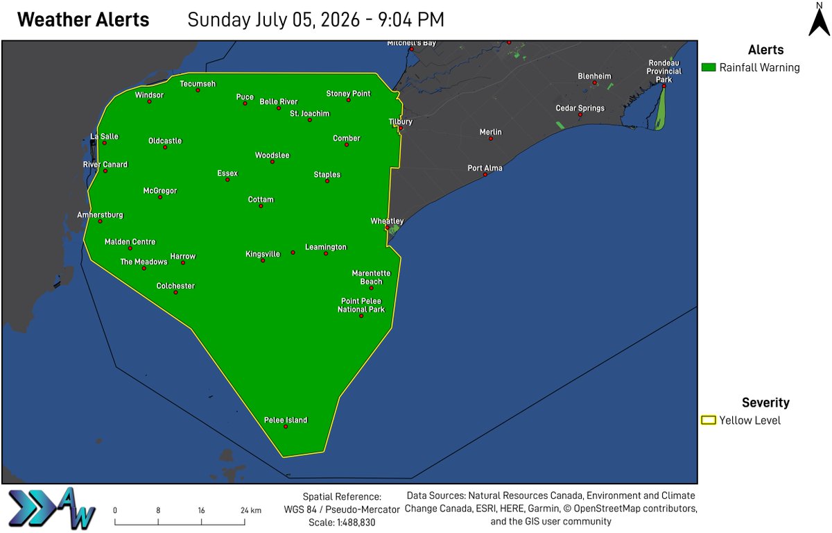
9:04 PM ET - Rainfall Warning (Yellow) issued for #Windsor - #Leamington - Essex County by Environment Canada.
Additional rainfall amounts possibly exceeding 50 mm by midnight for some areas.
A line of showers located from La Salle to Tecumseh will continue to give heavy rainfall for the next few hours.
Excessive rainfall amounts may be possible.
The upcoming week is expected to bring a slight chance of showers mid-week with temperatures mainly remaining in the 20s.
Temperatures in yellow represent forecasted Humidex values.
Monday will bring heavy rain at times to the Golden Horseshoe, with some showers in Southwestern Ontario and the GTA. Clouds will decrease through the day, leading to mainly sunny skies to sun mixing with clouds elsewhere.
Rain and thunderstorms in the Golden Horseshoe and Niagara Region are likely to produce torrential downpours and will be slow moving at times, and may become stationary. This is expected to lead to localized flooding. The exact locations impacted remain uncertain at this time.