LA Rams & UCLA fan! Frmr tennis player & LOVES sports, RRs, tornadoes & women's hoops. Frmr Revenue Acctg Senior at CPKC & now RR Consultant. U of Iowa grad.
@RailroadRaccoon Love those ATSF U30CGs but had read somewhere that they were heartily detested by ATSF crews - especially going through crossovers at track speed.
🌀 Chicago, Milwaukee, and Madison, you're in the crosshairs tomorrow.
A cluster of supercells should already be cranking by sunrise over Missouri, then bulk up into one organized complex that rolls through southern Wisconsin and northern Illinois by early afternoon. With a 60-80 kt jet overhead, the best shot at strong EF2+ tornadoes and 75+ mph winds is right in there.
This one ramps up fast in the morning, so don't sleep on it.
The best chance at seeing a tornado today will be near Cedar Rapids, Rochester, and Madison.
EF-2+ tornadoes will be possible anywhere from Northern Missouri to Northern Wisconsin, with several tornadoes likely from both a line of thunderstorms and discrete supercells.
Now is a great time to brush up on the tornado action plan. It's been a while since we've had a significant tornado day in the Midwest!
.@AdamSchefter on Aaron Donald potentially coming out of retirement:
“I think when they present a plan to him on how he’d be used… I think it’s more likely than not that he’ll be back.”
(Schefter then confirms nobody has said Donald would return yet)
Today's strong tornado risk is highly conditional given messy storm mode with multiple rounds of storms and pretty unfavorable boundary/jet streak orientation. However, scattered hurricane force wind gusts is likely for portions of IA, WI, and IL.
Growing increasingly concerned about intense severe weather impacting southern WI during peak heating Wed. afternoon. AM storms stay well north (hail threat) with storms rapidly firing in the afternoon. Tornadoes, large hail, and damaging straight-line winds are all on the table.
Widespread and numerous severe storms are forecast across parts of the midwest today.
All significant severe hazards are likely, including the potential for strong (EF2+) tornadoes, 75mph+ wind gusts, and 2"+ hail.
The storm mode may get messy early on, but any supercells that can remain discrete will have the greatest hail and tornado threat.
Morning round of storms is ongoing across Northern WI while the rest of the state is dry and heating up.
Still expecting potent severe storms between 2-6pm with tornadoes and damaging winds. More storms are expected in the evening.
Have a way to receive warnings today!
Wisconsin, Iowa, and Illinois are in for some big time storms today.
Storms already firing predawn over Iowa, then the real show comes late afternoon along the cold front: supercells with hail over two inches, a few strong EF2+ tornadoes, and gusts topping 75 mph. SPC has a Level 3 of 5 up.
The tricky part is those morning storms seeding where things redevelop near the Iowa/Illinois line, so it may go multiple rounds into tonight.
Heads up if you’re in the Midwest—the weather is looking incredibly messy for the next couple of days. We have a multi-day severe storm threat ramping up this afternoon, and it’s covering a massive chunk of the region.
Here is what you need to know:
Today (Wednesday)
Tornadoes & Hail: TOR:CON values are hitting a 5 around Davenport, a 4 up by Marquette, and a 3 near Des Moines/Minneapolis. Huge hail (2"+ diameter) is also a major risk, especially along that IA/IL/MO border area.
Widespread Wind: Damaging straight-line winds are likely to be the main issue as the afternoon goes on, with gusts potentially clearing 75 mph across MN, WI, IA, and IL.
Tomorrow (Thursday)
The Threat Shifts South/East: The severe weather risk moves further into the heart of Illinois, Indiana, Lower Michigan, and parts of Missouri.
Winds Crank Up: The "Very Likely" wind damage zone expands significantly tomorrow, covering places like Chicago, Milwaukee, Peoria, and Grand Rapids.
Tornado Threat Persists: TOR:CON counts stay at a 5 for parts of IL/IN, a 4 near Des Moines, and a 3 around Kansas City. 2"+ hail is still very much on the table for tomorrow too.
Basically, both days are bringing the full trifecta: destructive winds, large hail, and tornadoes. Make sure you have your severe weather alerts turned on today and tomorrow, secure anything loose outside before the storms hit, and know exactly where your safe spot is. Stay safe out there!
An Enhanced risk has been drawn up from the Upper Midwest down to Kansas City. Storms will pose threats for all hazards this afternoon across the risk area, with the greatest concentration of storms will be in the Cornbelt where multiple rounds of storms are likely.
These storms will likely be linear with the greatest tornado threat coming from QLCS spin-ups. Some significant wind gusts (70 MPH) or higher are possible as well. With repeated rounds of storms dropping heavy rain, localized flooding is possible.
Additional gusty storms are possible down the cold front into the central plains where localized flooding will also be a concern with slow moving and training storms.
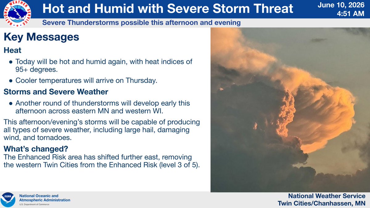
Morning storms clear by mid-morning, but rising heat and humidity will quickly prime the atmosphere for another round of strong to severe thunderstorms this afternoon. All severe weather hazards are on the table. Stay weather aware. #mnwx#wiwx
8:50pm Tues. 6/9: New data coming in and it isn't good. Please have a severe weather plan in place starting late morning on Wednesday, Wednesday afternoon, Wednesday night and midday/afternoon on Thursday into the evening. Several rounds expected. Standby for a comprehensive post.
The environment near the Warm Front on Thursday could be VOLATILE for tornadoes 👀.
Although not a direct representation of tornado chances, it does show how well ingredients needed for tornadoes overlap in a small area. On Thursday, they will overlap very nicely. IF a storm can organize and take advantage of this environment, strong tornadoes are in the cards for Northern Illinois and Southern Wisconsin. Stay tuned for more updates to this forecast!
@JagerDanger@mage_leader Depends which host RR you're traveling on. My former employer @CPKCrail does an excellent job in dispatching passenger trains on its network. @BNSFRailway has room for improvement but they generally do a good job.