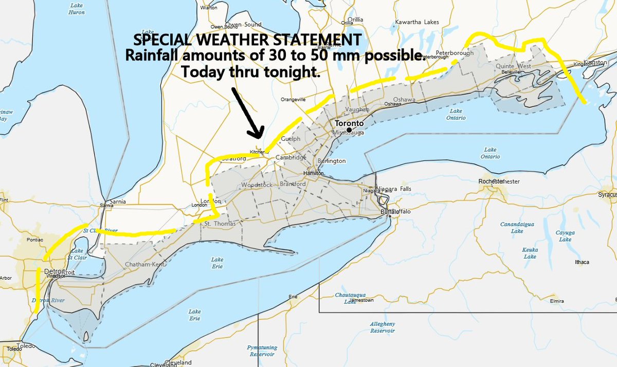
Might feel like the hottest day so far in S. Ontario with humidex values near 40 this afternoon. More scattered showers & isolated t-storms are possible later today around Lake Erie & Ontario into E. Ontario. Risk of isolated strong gusts and 20-40+ mm of rain. #onwx#onstorm
Some scattered showers & thunderstorms are expected across S. Ontario today & tomorrow with a tropical air mass moving in. Small risk of localized heavy downpours and gusty winds. Over 50 mm of rainfall is possible from slow moving/training storms. #onwx#onstorm
@julienalla11333 There is still a small risk for isolated severe in E. Ontario this afternoon. Not sure about later next week, lots of moisture and instability, but too far out to predict severe.
Lots of heavy rain moving into the northern part of C. Ontario this morning with a cluster of showers and embedded storms. Might have to watch this for re-intensification in E. Ontario later this afternoon. #onwx#onstorm
Thunderstorm Outlook for tomorrow PM 👇
Risk of severe storms across parts of SW/ Eastern #Ontario
Zone A- 90km/hr wind gusts and 2-3cm hail
Zone B- 90km/hr wind gusts, 2cm hail, 30-50mm of rain
#OnWX#ONStorm
@audio_nut Looks like near Lake Erie and E. Ontario have the highest risk with a later cold front passage. Guidance does show a couple of strong storms around the GTA in the early afternoon, though.
Some rain finally on the way to S. Ontario tonight & tomorrow with humid air ahead of a cold front. A few showers & scattered t-storms are possible with a trace to 10 mm for most, locally heavy in storms. Risk of isolated strong/severe storms tomorrow afternoon. #onwx#onstorm
Not too often that we get strong winds gusting up to 70-80 km/h from the north in E. Ontario. Just had a mature maple tree split in half in the backyard. #onwx#onstorm
Look's like ECCC expanded this overnight from deep SWONT thru to the north shoreline of L. Erie & L. Ontario.
👉https://t.co/48en2YeYZm
Morning! 🥱☕️☕️☕️+++
#onwx#onstorm
Scattered thunderstorms are likely later this afternoon & early evening across SW & C Ontario ahead of a strong cold front. Slight risk of severe storms with damaging gusts the main threat. Isolated large hail and a brief tornado are also possible. #onwx#onstorm
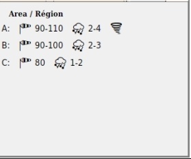
Thunderstorm Outlook for Tuesday PM (tomorrow) 👇
Risk of severe storms across parts of Southern #Ontario
Zone A- 90-110km/hr gusts, 2-4cm hail and a Tornado is possible
Zone B- 90-100km/hr gusts, 2-3cm hail
Zone C- 80km/hr gusts, 1-2cm hail
#OnWX#ONStorm
@julienalla11333 Scattered storms with a slight risk of severe for most of S. Ontario. Damaging gusts are the main risk, but there's some ingredients for a brief isolated tornado.
Brief taste of summer today & tomorrow across S. Ontario. Another line of storms is possible near Michigan & Lake Huron late afternoon & early evening with a risk of isolated severe. Might be a risk for an isolated tornado around Algonquin Park. #onwx#onstorm