Geospatial data manager & data sharing lead at @NaturalEngland, sharing #opendata#DefraData, @ArcGISOnline @LivingAtlas #avgeek, rugby league supporter.
November 2024: Check out our extensive batch of @NaturalEngland#geospatial#OpenData updates https://t.co/YcVUasvI6L No updates in December, next publications January 2025. 🌳🌍
As biodiversity takes priority in land development in England, GIS is being tapped to illustrate where natural lands are now and where they can grow. 🌱 Details: https://t.co/UHta2GkxvZ
#Biodiversity#Nature
The new Living England 2022-23 habitat map is now live! Download freely from https://t.co/rR1gT2IaPl (coming soon on Magic). It’s more reliable & user-friendly than ever - providing essential habitat data for natural capital monitoring across England.
Starting with #ArcGISPro 3.2, you can export all symbols in the map as style items and save them to a style in a single process! Want to learn more? Check out the blog below. 🌎
Read the blog:
https://t.co/uOAx6HdlW1
Science, evidence and analysis are at the heart of what Natural England does. I am incredibly proud of the work we have been able to showcase this #BritishScienceWeek, this is a taste of the range of specialisms across NE and the vital work we are delivering for nature recovery
November 2023: Natural England #geospatial#OpenData Geoportal updates and new release. Check out the Moorland Change Map 2022-2023. Updates include designated sites, SSSI Impact Risk Zones, England Coast Path & Great Crested Newts planning areas https://t.co/pgHfAUEVaT🌳🌍
Help us improve MAGIC!
Natural England and Defra are conducting user research on our MAGIC interactive map service.
We need your help to inform future improvements by completing a short survey:
https://t.co/HvScAOoEsd
The survey takes 10 minutes and closes on 29th Oct.
@owenboswarva@NaturalEngland Hi @owenboswarva Good news. I'll ask the data custodian if they'll consider including all attributes in their published SSSI Units geospatial dataset. It will need QA and extra processing, but seems silly that users like yourself have to request and append this info separately.
September 2023 data updates: SSSI Units boundaries showing condition status, England Coast Path route & margin released on @NaturalEngland Open Data Geoportal https://t.co/YcVUasvahd #DefraData@NEChiefSci
The new Maps+ Beta Services are now live and available to existing Maps+ subscribers from within the #ArcGIS Marketplace. To see what the hype is about, follow along as we test out these services, trial workflows and of course - make some #maps.
https://t.co/EAVVwFhTVm
#GIS
Opening day is here!🤩 Our spatial data science #MOOC has started, and everyone is invited to join - nearly 25,000 people already have. We hope to see you online! Start whenever you're ready.
Join the course: https://t.co/Tqg4F5rcoz
New to @ArcGISPro? Here are our top 2️⃣ courses to help you get started⬇️
💻FREE self-paced web course: https://t.co/GeX5mBJgMj
👩💻3-day instructor-led course: https://t.co/2BfNjUkpxB
August 2023 data updates: 3 x designated sites boundaries & England Coast Path route/margin released on @NaturalEngland#opendata Geoportal https://t.co/nHlfH5itAj #DefraData@NEChiefSci
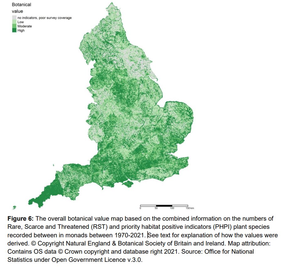
New release: Summarised Botanical Value Map 2022 (England) #geospatial#opendata layer on @NaturalEngland 's Open Data Geoportal https://t.co/feGpeQS6Bh and Defra Data Services Platform https://t.co/hGdKNP807O
Our #BotanicalHeatmaps help to inform where tree and woodland cover could enhance biodiversity, and where to avoid planting to protect existing nature-rich habitat.
Find our updated Summarised Botanical Value map, in partnership with @BSBIBotany, here: https://t.co/KosmTzdR81
Do you have a passion for enabling access to #geospatial data on digital platforms and transforming #GIS data provision workflows and guidance? @NaturalEngland are looking for a permanent Geospatial Data Sharing Lead Adviser https://t.co/yybUGIAorw Deadline Monday 19/06/2023
Many people have asked if my "hands-on" session at the #EsriUKAC this week is available. So, if you want to know how to run geoprocessing tools through #Python in #ArcGISPro then please click the link - data & instructions are included at the download page
https://t.co/pOLbZyIYf4
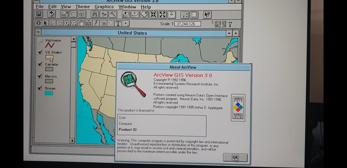
Adam Branscomb @esriuk gives #ArcView 3.0 a cameo appearance at #EsriUKAC harking back to the forerunner for the capabilities we've become familiar with today. Some of us remember and still love it! 🤣👏