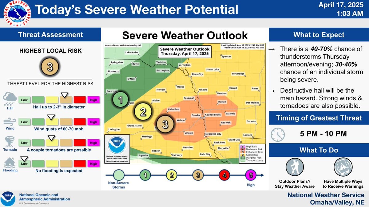
Probability of individual severe weather hazards later this evening. The storms that develop will likely be supercells. These will have the potential to produce 2" hail or bigger, wind gusts up to 70 mph, and perhaps a tornado or two. Be weather aware later today. Timing 5-10 pm.
Confidence is increasing that a few intense storms will develop this evening across portions of eastern NE and southwest IA. The primary hazard is expected to be destructive hail up to 2 or 3" in diameter. A tornado or two is also possible, as are damaging winds up to 60-70 mph.
More snow is possible Tuesday night into Wednesday as another strong winter storm moves through the region. There's a 50-60% chance of at least minor impacts with measurable snow possible. North-northwest winds could also gust 30-50 mph as well creating areas of blowing snow.
We've updated the timing of greatest threat for severe storms to 4-7 PM. Primary threat will still be wind gusts.
⚠️Some 80mph! 👀
The probability of storms increases from west to east.
Significant travel impacts are expected later today through tonight due to the combination of very strong winds and snow. For additional information, see: https://t.co/PbOHDmVbef
A strong storm system is still on track to impact the area with rain, snow, and strong to damaging winds Tuesday into Wednesday. Travel will be difficult at times.
More details are available here: https://t.co/PbOHDmVbef
A portion of the area has been placed in a moderate risk for excessive rainfall. Repeated rounds of thunderstorms and showers overnight may lead to localized flash flooding.
𝟴:𝟱𝟬 𝗔𝗠 𝗨𝗣𝗗𝗔𝗧𝗘
Confidence in a damaging wind threat grows.
Much of the area is now considered to have an 𝗘𝗡𝗛𝗔𝗡𝗖𝗘𝗗 𝗥𝗜𝗦𝗞 of severe weather this evening. Wind gusts of 60mph to 80mph+ will be possible.
Please make plans to seek shelter quickly.
A line or severe thunderstorms capable of producing hail (1" or greater), damaging winds, and tornadoes is moving northeast through the area.
Have multiple ways to receive warnings this morning.
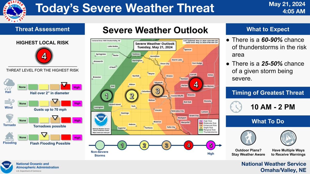
Severe storms are expected this morning into early afternoon (10 AM - 2 PM) with all hazards possible. The greatest severe weather threat area is far eastern Nebraska and southwest Iowa where an Enhanced to Moderate Risk (level 4 of 5) is being forecast.
Yesterday's Elkhorn-Omaha wedge - I've seen a lot of tornadoes but I have never watched one approach a major metro area that had quite this kind of power. This is raw footage, cropped and watermarked but nothing else. @NWSOmaha#newx
MRMS low-level rotation data shows the approximate path of three tornadoes that impacted Omaha, Nebraska 🇺🇸 in the past few hours:
▪️ One impacted the western suburbs, including Elkhorn
▪️ One developed north of downtown near Carter Lake
▪️ One passed east of the city
#NEwx
🚨#BREAKING: A tornado emergency has been declared for a confirmed large and life-threatening catastrophic tornado
📌#Bennington | #Nebraska
The National Weather Service has issued a tornado emergency for Bennington NE, Blair, NE, Missouri Valley, IA, and Valley, NE, as a confirmed, wide, large, catastrophic, and extremely violent tornado is on the ground. Residents in the area should take shelter immediately, as this is a life-threatening situation again this is a confirmed, extremely large, and damaging tornado on the ground causing ife-threatening catastrophic damage
An impactful winter storm is still on track to move in overnight and last through Tuesday morning. If you have plans to commute to work on Monday, be prepared for a nasty drive home (or try to avoid driving if you can)!
Rain this evening will turn to snow overnight, with moderate to heavy snow expected from 3 AM to 7 AM. Overnight and early Sunday commuters should expect slick road conditions along Interstate 80, with any remaining snowfall exiting the area by 10 AM.