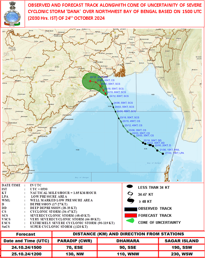
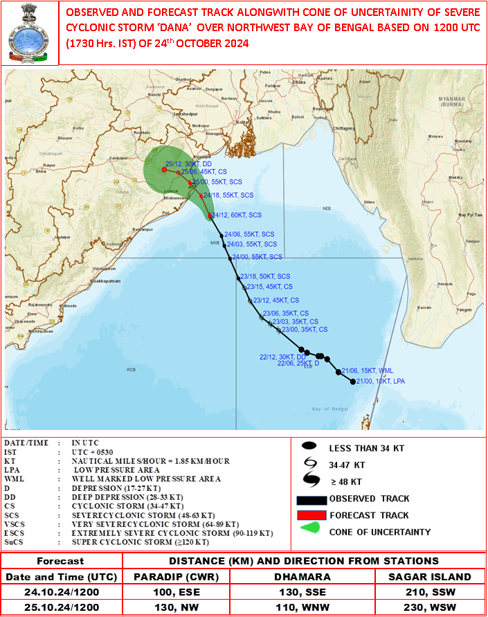
#CycloneDana continues to move northwestwards, and may cross between Soro and Chandipur in #Odisha. Coastal districts of #WestBengal will also get affected. It's currently a severe cyclone, powerful Category 1. With winds up to 125 kph, gusting up to 150 kph. #Dana
THE SEVERE CYCLONIC STORM “DANA” (PRONOUNCED AS DANA) OVER NORTHWEST BAY OF BENGAL MOVED NORTHNORTHWESTWARDS WITH A SPEED OF 17 KMPH DURING PAST 06 HOURS AND LAY CENTRED AT 0230 HRS IST OF TODAY, THE 25TH OCTOBER, OVER ODISHA COAST NEAR LATITUDE 20.75° N AND LONGITUDE 86.95°E, ABOUT 10 KM SOUTHEAST OF DHAMARA AND 10 KM NORTH-NORTHWEST OF HABALIKHATI NATURE CAMP (BHITARKANIKA). LATEST OBSERVATIONS INDICATE THAT THE SYSTEM IS CROSSING THE COAST.
LATEST OBSERVATIONS INDICATE THAT THE SYSTEM IS CROSSING THE NORTH ODISHA COAST CLOSE TO HABALIKHATI NATURE CAMP (BHITARKANIKA) AND DHAMARA AS A SEVERE CYCLONIC STORM WITH A WIND SPEED OF 100-110 KMPH GUSTING TO 120 KMPH. LANDFALL PROCESS CONTINUES AND THE FORWARD SECTOR OF THE WALL CLOUD REGION HAS ENTERED INTO THE LAND. THE LANDFALL PROCESS WOULD CONTINUE TILL TODAY, THE 25TH OCTOBER MORNING.
AFTER LANDFALL IT IS LIKELY TO MOVE NEARLY WESTNORTHWESTWARDS ACROSS NORTH ODISHA AND WEAKEN GRADUALLY INTO A CYCLONIC STORM BY FORENOON OF TODAY, THE 25TH OCTOBER.
THE SEVERE CYCLONIC STORM “DANA” (PRONOUNCED AS DANA) MOVED NORTH-NORTHWESTWARDS AND CROSSED THE NORTH ODISHA COAST CLOSE TO HABALIKHATI NATURE CAMP (BHITARKANIKA) AND DHAMARA DURING 0130-0330 HRS IST OF TODAY, THE 25TH OCTOBER AS A SEVERE CYCLONIC STORM WITH A WIND SPEED OF 100-110 KMPH GUSTING TO 120 KMPH. IT LAY CENTRED AT 0330 HRS IST OF TODAY, THE 25TH OCTOBER, OVER NORTH COASTAL ODISHA NEAR LATITUDE 20.85° N AND LONGITUDE 86.90°E, ABOUT 10 KM NORTH OF DHAMARA AND 20 KM NORTH-NORTHWEST OF HABALIKHATI NATURE CAMP (BHITARKANIKA).
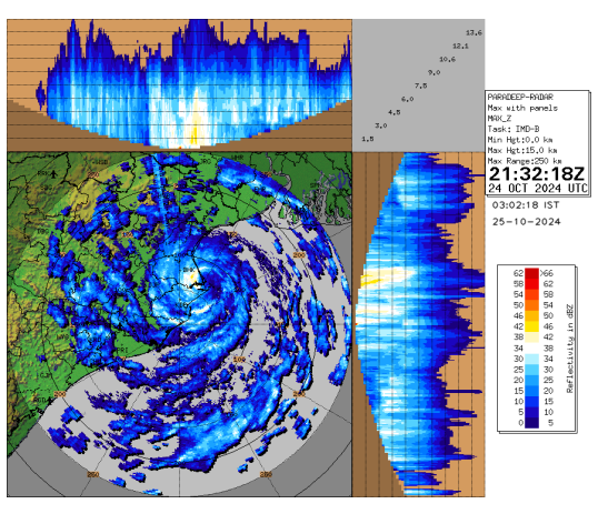
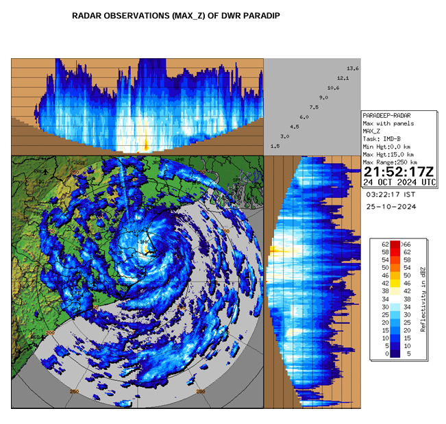
LANDFALL PROCESS CONTINUES AND THE REAR SECTOR OF THE CYCLONE IS ENTERING INTO LAND. THE LANDFALL PROCESS WOULD CONTINUE FOR NEXT 2-3 HOURS. IT IS LIKELY TO MOVE NEARLY WEST-NORTHWESTWARDS ACROSS NORTH ODISHA AND WEAKEN GRADUALLY INTO A CYCLONIC STORM BY FORENOON OF TODAY, THE 25TH OCTOBER. THE SYSTEM IS UNDER CONTINUOUS SURVEILLANCE OF THE DOPPLER WEATHER RADAR AT PARADIP.
THE SEVERE CYCLONIC STORM “DANA” (PRONOUNCED AS DANA) OVER NORTHWEST BAY OF BENGAL MOVED NORTH-NORTHWESTWARDS WITH A SPEED OF 15 KMPH DURING PAST 06 HOURS AND LAY CENTRED AT 0030 HRS IST OF TODAY, THE 25TH OCTOBER, OVER THE SAME REGION, NEAR LATITUDE 20.60° N AND LONGITUDE 87.05°E, ABOUT 50 KM NORTHEAST OF PARADIP (ODISHA), 30 KM SOUTHEAST OF DHAMARA (ODISHA) AND 160 KM SOUTHWEST OF SAGAR ISLAND (WEST BENGAL).
IT IS VERY LIKELY TO CONTINIUE TO MOVE NORTH-NORTHWESTWARDS AND CROSS NORTH ODISHA COAST CLOSE TO BHITARKANIKA AND DHAMARA (ODISHA) DURING NEXT 2 HOURS AS A SEVERE CYCLONIC STORM WITH A WIND SPEED OF 100-110 KMPH GUSTING 120 KMPH.
LANDFALL PROCESS CONTINUES AND THE FORWARD SECTOR OF THE WALL CLOUD REGION CONTINUES TO ENTER INTO LAND. THE LANDFALL PROCESS WOULD CONTINUE TILL TODAY, THE 25TH OCTOBER MORNING.
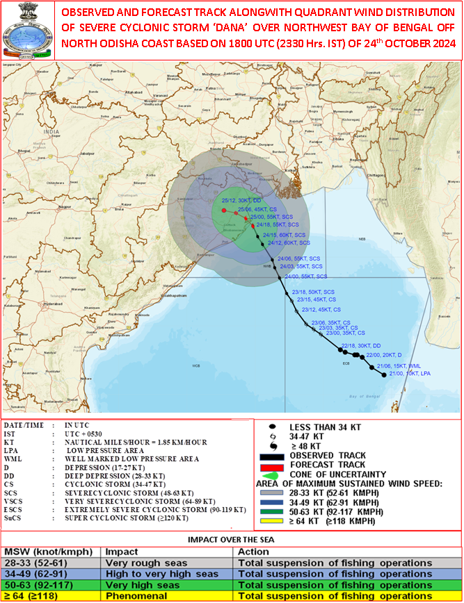
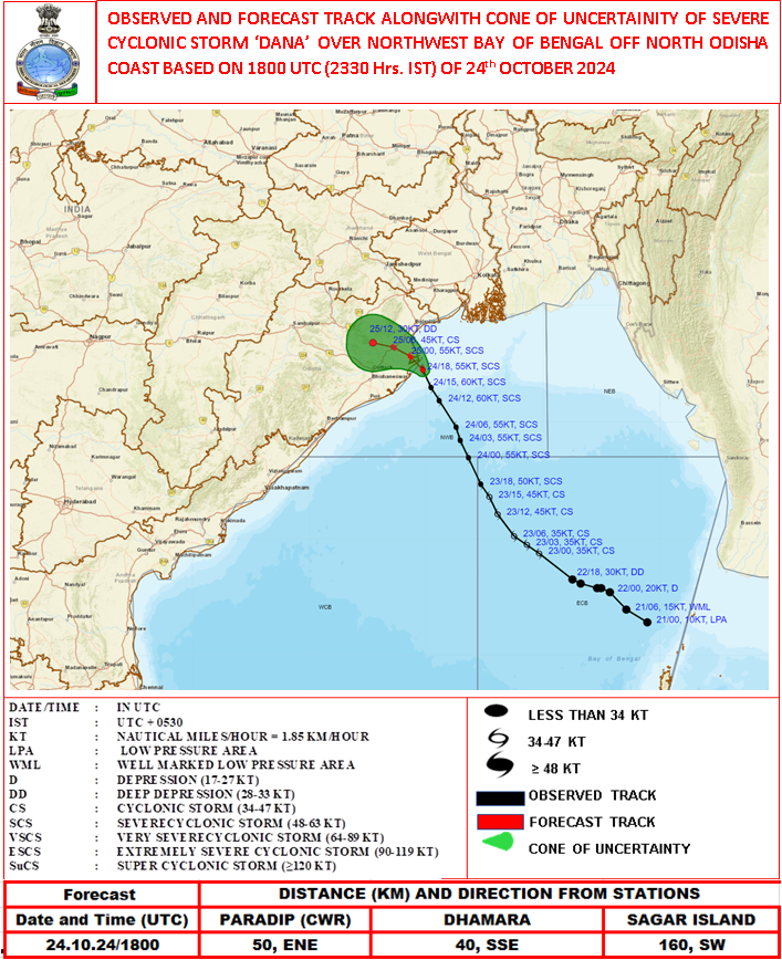
THE SEVERE CYCLONIC STORM “DANA” (PRONOUNCED AS DANA) OVER NORTHWEST BAY OF BENGAL MOVED NORTH-NORTHWESTWARDS WITH A SPEED OF 15 KMPH DURING PAST 06 HOURS AND LAY CENTRED AT 2330 HRS IST OF YESTERDAY, THE 24TH OCTOBER, OVER THE SAME REGION, NEAR LATITUDE 20.50° N AND LONGITUDE 87.10°E, ABOUT 50 KM EAST-NORTHEAST OF PARADIP (ODISHA), 40 KM SOUTH-SOUTHEAST OF DHAMARA (ODISHA) AND 160 KM SOUTHWEST OF SAGAR ISLAND (WEST BENGAL).
IT IS VERY LIKELY TO MOVE NORTH-NORTHWESTWARDS AND CROSS NORTH ODISHA AND WEST BENGAL COASTS BETWEEN PURI AND SAGAR ISLAND CLOSE TO BHITARKANIKA AND DHAMARA (ODISHA) DURING NEXT 3 TO 4 HOURS AS A SEVERE CYCLONIC STORM WITH A WIND SPEED OF 100-110 KMPH GUSTING 120 KMPH.
LANDFALL PROCESS HAS COMMENCED AND THE FORWARD SECTOR OF THE WALL CLOUD REGION IS ENTERING INTO LAND. THE LANDFALL PROCESS WOULD CONTINUE TILL TODAY, THE 25TH OCTOBER MORNING.
The severe cyclonic storm “DANA” (pronounced as Dana) over northwest Bay of Bengal moved north-northwestwards with a speed of 15 kmph during past 6 hours and lay centred at 2330 hrs IST of yesterday, the 24th October, over the same region, near latitude 20.5° N and longitude 87.1°E, about 50 km east-northeast of Paradip (Odisha), 40 km south-southeast of Dhamara (Odisha) and 160 km southwest of Sagar Island (West Bengal).
It is very likely to move north-northwestwards and cross north Odisha and West Bengal coasts between Puri and Sagar Island close to Bhitarkanika and Dhamara (Odisha) during next 3 to 4 hours as a severe Cyclonic Storm with a wind speed of 100-110 kmph gusting 120 kmph.
Landfall process has commenced and the forward sector of the wall cloud region is entering into land. The landfall process would continue till today, the 25th October morning.
The system is under continuous surveillance of the Doppler Weather Radar at Paradip.
National Bulletin No. 20 based on 2330 hours IST of 24th October, 2024: Severe Cyclonic storm “DANA” :
Landfall process has https://t.co/FvLjrZ3D4B lay near latitude 20.5° N and longitude 87.1°E, about 50 km east-northeast of Paradip (Odisha), 40 km south-southeast of Dhamara (Odisha) and 160 km southwest of Sagar Island (West Bengal). It is very likely to move north-northwestwards and cross north Odisha and West Bengal coasts between Puri and Sagar Island close to Bhitarkanika and Dhamara (Odisha) during next 3 to 4 hours as a severe Cyclonic Storm with a wind speed of 100-110 kmph gusting 120 kmph. Landfall process has commenced and the forward sector of the wall cloud region is entering into land. The landfall process would continue till today, the 25th October morning.
THE SEVERE CYCLONIC STORM “DANA” (PRONOUNCED AS DANA) OVER NORTHWEST BAY OF BENGAL MOVED NORTH-NORTHWESTWARDS WITH A SPEED OF 13 KMPH DURING PAST 3 HOURS AND LAY CENTRED AT 2230 HRS IST OF TODAY, THE 24TH OCTOBER, OVER THE SAME REGION, NEAR LATITUDE 20.30° N AND LONGITUDE 87.20°E, ABOUT 50 KM EAST OF PARADIP (ODISHA), 60 KM SOUTH-SOUTHEAST OF DHAMARA (ODISHA) AND 170 KM SOUTH-SOUTHWEST OF SAGAR ISLAND (WEST BENGAL).
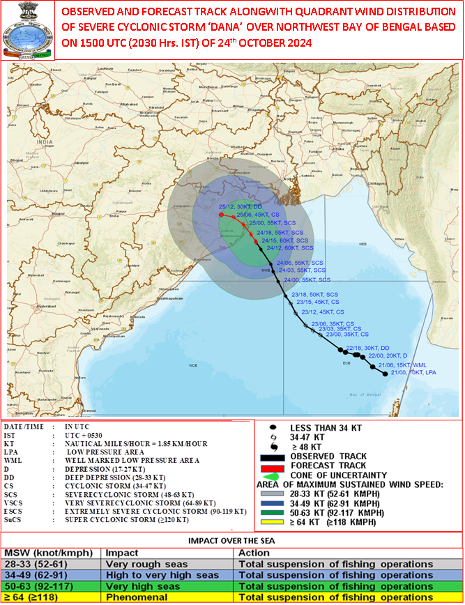
THE SEVERE CYCLONIC STORM “DANA” (PRONOUNCED AS DANA) OVER NORTHWEST BAY OF BENGAL MOVED NORTH-NORTHWESTWARDS WITH A SPEED OF 15 KMPH DURING PAST 6 HOURS AND LAY CENTRED AT 2030 HRS IST OF TODAY, THE 24TH OCTOBER, OVER THE SAME REGION, NEAR LATITUDE 20.10° N AND LONGITUDE 87.30°E, ABOUT 70 KM EAST-SOUTHEAST OF PARADIP (ODISHA), 90 KM SOUTH-SOUTHEAST OF DHAMARA (ODISHA) AND 190 KM SOUTH-SOUTHWEST OF SAGAR ISLAND (WEST BENGAL).
The severe cyclonic storm “DANA” (pronounced as Dana) over northwest Bay of Bengal moved north-northwestwards with a speed of 13 kmph during past 6 hours and lay centred at 1730 hrs IST of today, the 24th October, over the same region, near latitude 19.8° N and longitude 87.5°E, about 100 km east-southeast of Paradip (Odisha), 130 km south-southeast of Dhamara (Odisha) and 210 km south-southwest of Sagar Island (West Bengal).
It is very likely to move north-northwestwards and cross north Odisha and West Bengal coasts between Puri and Sagar Island close to Bhitarkanika and Dhamara (Odisha) during mid-night of 24th to morning of 25th October, 2024 as a severe Cyclonic Storm with a wind speed of 100-110 kmph gusting 120 kmph.
The system is under continuous surveillance of the Doppler Weather Radar at Paradip and Gopalpur.
Spiral Structure of Convective clouds associated with the Severe Cyclonic Storm "DANA" as seen from the Doppler Weather Radar at Paradip, Odisha (24Oct 2024, 1615-1915 IST)
IR Animation from INSAT 3DR (24.10.2024 1315-1815 IST) shows the convective clouds associated with the cyclone.
#DanaCyclone #CycloneUpdate #CycloneAlert #depression22Oct2024 #lowpressure21Oct2024
@moesgoi@ndmaindia@airnewsalerts@DDNewslive@DrJitendraSingh@osdmaodisha @wbdmcd
Landfall process has commenced and the forward sector of the wall cloud region is entering into land. The landfall process would continue till today, the 25th October morning.
The system is under continuous surveillance of the Doppler Weather Radar at Paradip.