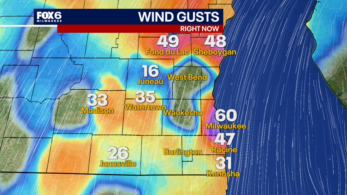
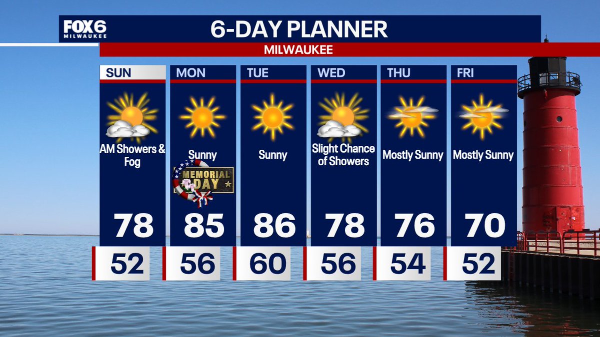
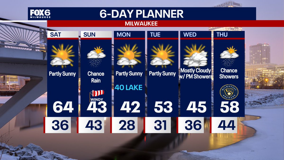
5/23 10:05 PM
A summer-like pattern provides sunshine and warm temperatures into next week. We do have a slight chance for showers so just have keep that in mind. Otherwise, enjoy your Memorial Day weekend.
https://t.co/8PEkdfmuNh
-Holly Baker
5/14 10:23pm: A few light rain showers early Friday morning, generally done by the AM commute. Clearing and windy on Friday with a high of 75. A few strong storms are possible between 1-3am on Saturday. Warm on Saturday with a high around 80. A few t-storms on Sunday (not an all day washout) with highs in the upper 70s. We are watching the storm system closely for early next week, the storm timing (ie. cold front timing) is in question, which will dictate where the strongest storms will form. Stay tuned.
5/13 10:40pm: Sunny on Thursday with highs in the 60s. Light rain (0.10" or less) overnight Thursday night and ending by 6-7am Friday. Windy and warm on Friday. Stay tuned for t-storm chances on Saturday, unclear if we will see any and when. It will be warm on Saturday. A bit rainy at times on Sunday with a big warm up on Monday along with more chances for storms (some of those could be strong). But 80s return to the forecast.
4/27 10:55pm: Storms ending overnight. Mostly cloudy on Tuesday with a high around 60. Rain showers Tuesday night into Wednesday (around 0.20"). Cool mid-week through Saturday.
4/20 10:55pm: Big warm on Tuesday, slim chance for an afternoon rain shower. Cooler on Wednesday and warming back up on Thursday. Our next chance for t-storms is late Thursday night. The later the better for us, as it would likely weaken the storms to below severe limits before they reach us.
A Tornado Warning has been issued for parts of SE WI until 4/17 6:30PM. SEEK SHELTER IMMEDIATELY if you are in the warned area. Tune into FOX6. Download the FOX6 Storm Center App & FOX Local App. More at: https://t.co/jF6fOD6ijM
4/16 10:30pm: The 4th and FINAL round of severe t-storms will move through Friday between 4pm-12am. NO rain for most (if not all) of the next week. We've got this! We just have to get through this last batch. Dense AM fog on Friday. Storms will move into our western counties (ie. Dodge/Jefferson) after 4pm. A line of severe storms is expected in Milwaukee after 7pm. It could look similar to Wednesday night, 1-2" of rain is expected with flooding. Tornadoes, wind and hail will also be possible. We are staffed and ready to go. I will see you on-air with my colleagues at FOX6 bringing you coverage all afternoon and evening. I've never been more excited to see 40s and quiet for the weekend! Please stay tuned.
4/11 10:08 PM
You can expect a warm but stormy stretch ahead. Highs stay in the 70s most days, with multiple rounds of rain and thunderstorms through midweek. Stay weather aware!
https://t.co/8PEkdfmuNh
-Holly Baker
4/7 10:23pm: Light mix possible through 5am, all light rain for the AM commute on Wed. ending by Noon. 0.10" or less. Ready for a warm up? Windy with peeks of PM sun, highs in the low-to-mid 60s. More rain after 9pm Wednesday, ending before the Thu AM commute. 0.10"-0.20" expected. Dry on Thursday with heavy rain possible after 10pm Thursday night. Big warm up Sunday and Monday with t-storm chances returning.
Breaking. It will NOT be 60 tomorrow. The cold front is moving faster, which means 40s in Milwaukee on Thursday. Bundle up for tailgating with a stiff NE wind. Showers and t-storms are possible midday through the afternoon, ending during the evening.
10:52pm Monday 3/23: Partly sunny and warmer on Tuesday with highs in the low 50s. Warming up even more on Wednesday. Opening Day looks good. Can't rule out a few light rain showers for tailgating, otherwise temperatures around 60, dropping later in the day with a cold front. Weather whiplash continues late week as we drop into the 30s on Friday but rebound over the weekend.
3/22 10:25pm: The sun returns on Monday! It will still be chilly, but a warm up is on the way. No major storm systems in sight. 50s return on Tuesday, 60s on Wednesday and Thursday. As long as that cold front holds off, it looks nice for Opening Day tailgating.
3/20 10:51 PM
It was such a pleasant day today. Saturday will be another "Happy Holly Forecast" before the rain rolls in Sunday morning with cooler temperatures in the 40s. A rollercoaster ride in temperatures will be the trend for next week.
https://t.co/8PEkdfmuNh
-Holly Baker
Why did the forecast keep bouncing around before Sunday night’s blizzard?
The radar actually explains everything… and once you see it, the forecast swings make total sense.
Let’s take a look.
10pm Sunday: Breaking. WOW. 60mph wind gust already in Milwaukee. We will hit blizzard conditions very soon. Power outages will start to stack up as well. Have flashlights and blankets and charge up those phones (and portable chargers if you have them). Hunker down. We will be in this blizzard pretty much all day tomorrow. Keep it here, we've got you covered with updates. Remember, if you lose power, FOX LOCAL streaming app is a must have. We will have weather on there all night and all day. Stay warm and stay safe.
BLIZZARD WARNING?! How can we get a blizzard with as little as 3-5"of snow in Kenosha?! I've got the answer for you. We are LIVE on the FOX LOCAL app until at least 11pm. Post date: 3/15/26