Since today is the official start of the 2026 Hurricane Season, we want to remind you to be prepared. Make sure you assemble a disaster supply kit, and make a written plan now. Check out https://t.co/hiyaloZUPd for our 2026 hurricane guide! #TXwx 🌀
It's 29th anniversary of the Jarrell, TX F5 Tornado.
Still one of the most fascinating atypical tornado formation processes ever documented.
Extreme CAPE w/ No Shear + Favorable Boundary Interactions + Back-building mergers = Landspout-turned-F5 Grinder
From 2000 to 2020, the center of population of the Houston MSA moved a remarkable 2.9 miles northwest, one of the largest shifts of any US metro area. If trends have continued it's possible the center of population has crossed the Inner Loop (I-610) by 2026.
4 PM - Flash flood threat increasing across the Hill Country.
Radar trending worse with prolific rainfall moving very slowly and growing in scale. Rainfall rates 2"+ per hour #atxwx#txwx
9 PM - NEW WARNING for 70 MPH wind gusts (!!!) includes all of Travis County and most of Hays county.
Power outages and tree damage are likely. The wind will hit before the rain does. Get inside and have necessary electronics charged! #atxwx#txwx
Good morning! After a night of showers and storms, we will see conditions improving today.
The rest of the week is expected to remain tranquil but warmer.
A few rounds of showers & thunderstorms will develop over Southeast TX today & Saturday. Some storms may become strong to severe, capable of producing damaging winds & hail. Brief isolated tornado cannot be ruled out.
Make sure to have multiple ways of receiving warnings.
Primary area outlined here is in Montgomery County just north of Houston and Harris County.
“SUMMARY...Early morning elevated thunderstorms with potential to train this morning pose narrow axis of 2-4" totals and isolated flash flooding concerns near urban and areas of recent heavy rainfall.”
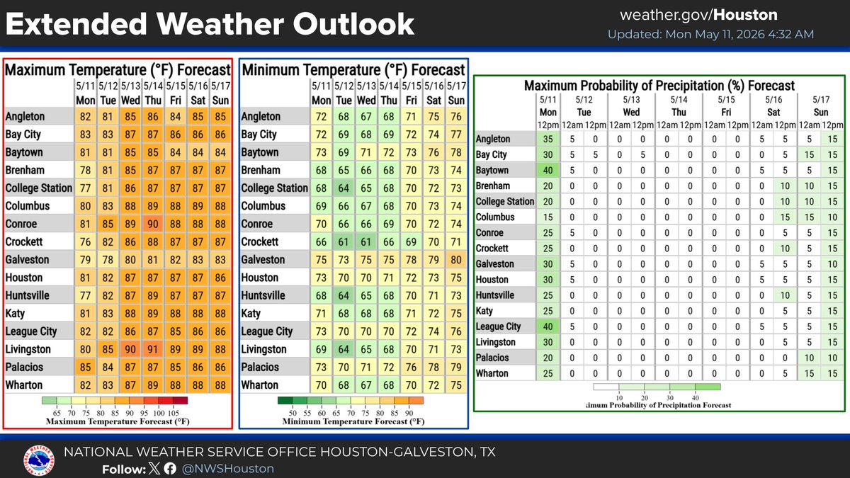
Our next chance for rain will be Wednesday into Thursday as a cold front approaches and slowly moves through the region. Isolated strong to severe storms will be possible Wednesday afternoon into Wednesday night ahead of and along the front. #HOUwx
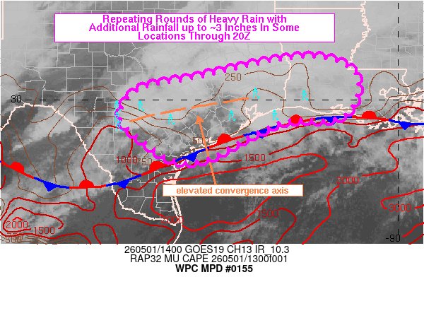
SUMMARY...Elevated thunderstorms will continue to affect SC into SE TX, reaching SW LA later this morning. Peak hourly rainfall values near 1” are expected although hourly rainfall near 2” will be possible closer to the upper TX & LA coast. Repeating rounds of additional rainfall may result in additional rainfall totals near 3” through 20Z in one or two locations.
Periods of heavy rain will move across Houston throughout the day. Some strong to severe storms are also possible this afternoon. Flood watches are posted, so give yourself extra time today. The rain will be followed by gusty winds. Matt has the latest. https://t.co/q5FkXRDsIE