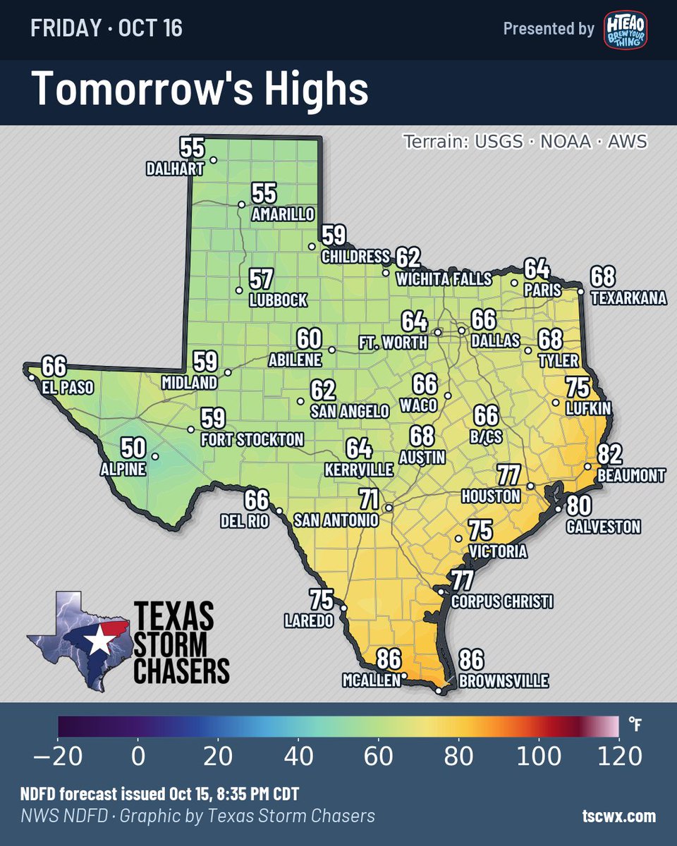
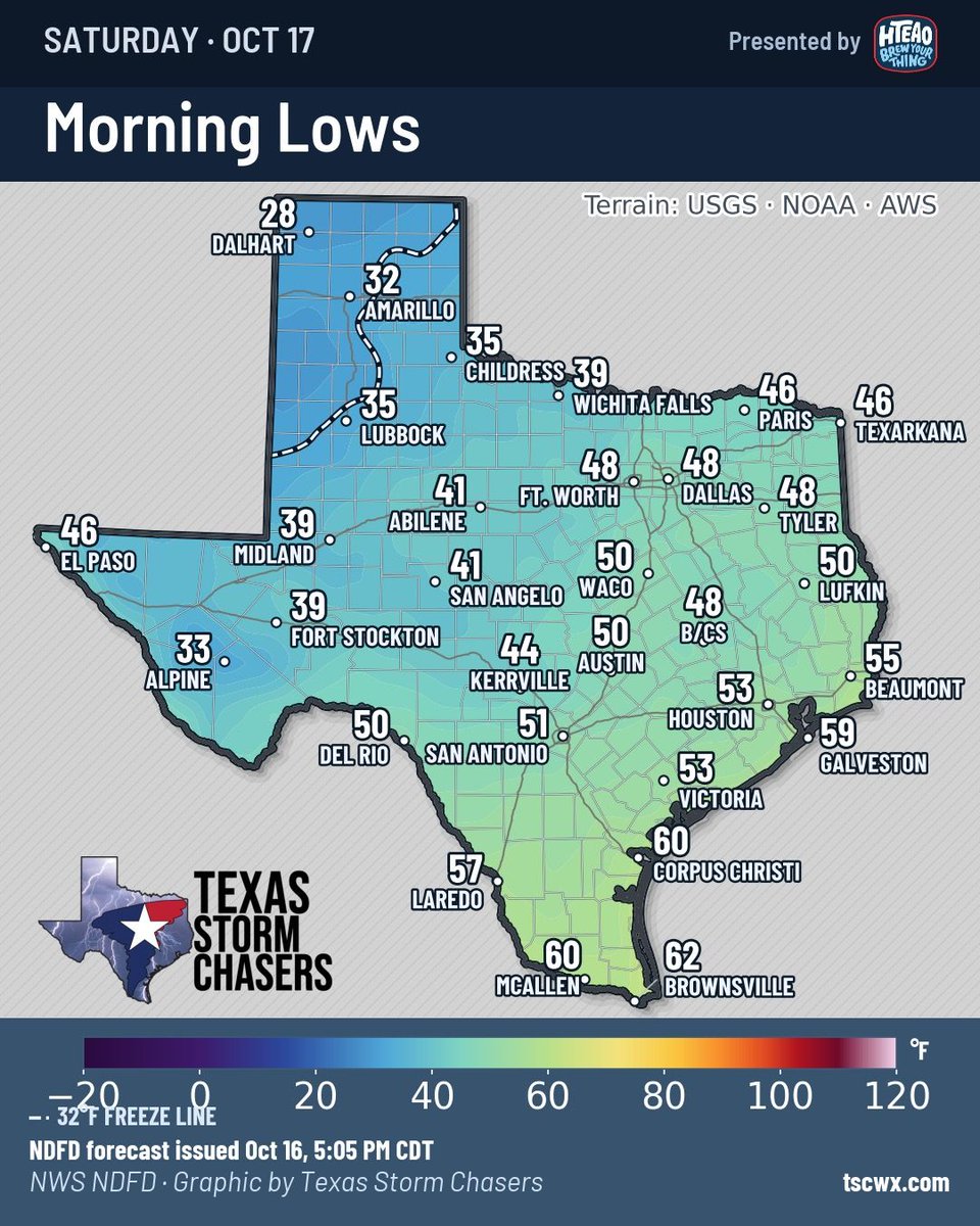
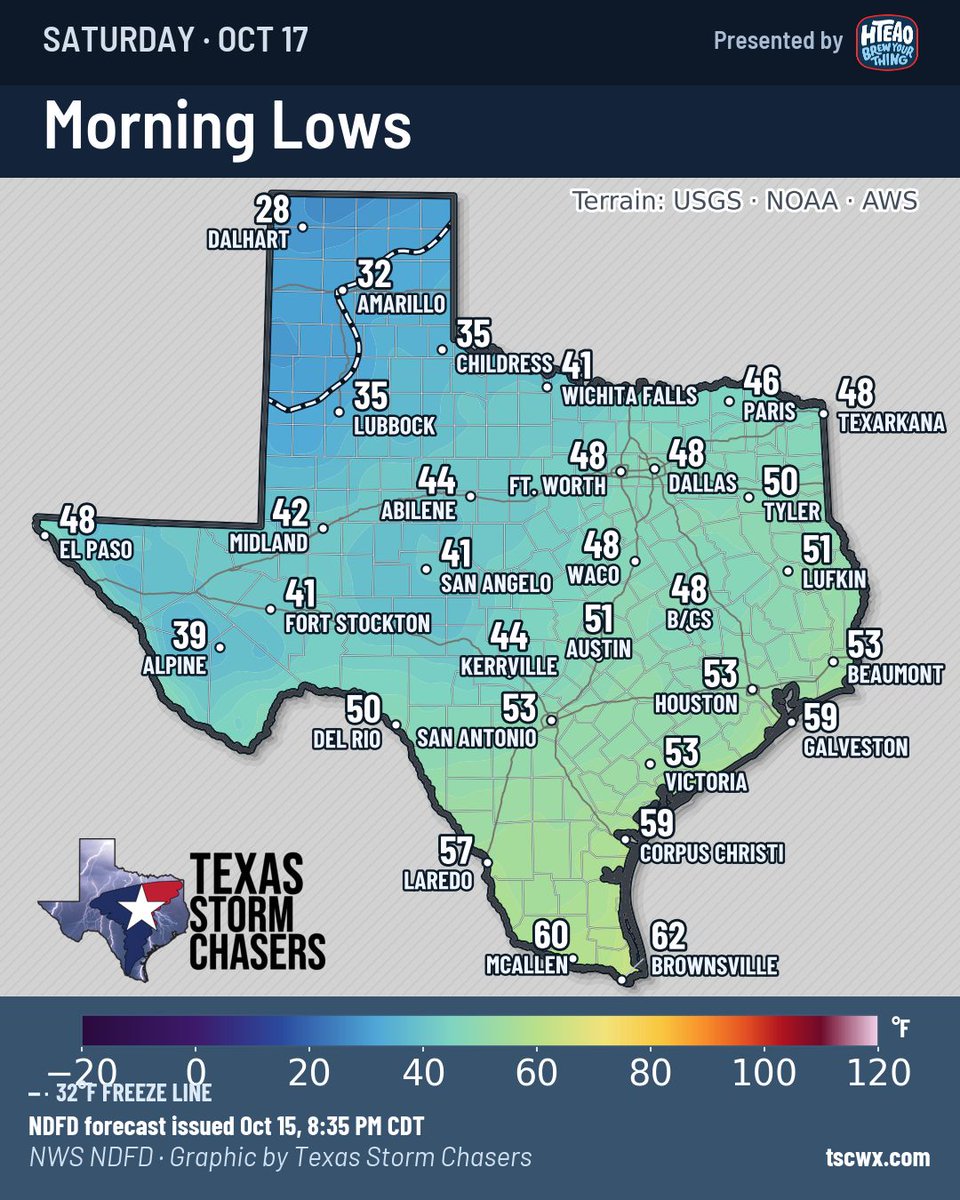
A strong cold front will move south across Texas tonight and Friday. North winds will gust over 40 MPH at times, so secure your outdoor decorations and lawn furniture. MUCH cooler weather arrives with the cold front. High temperatures will be in the 50s and 60s across western Texas on Friday. By Saturday morning, temperatures will drop into the 20s in the Panhandle, with 30s and 40s across northern and western Texas. Get out the sweaters and get ready for some wind chills!
BREAKING: State of emergency declared for 40 counties in central and southern Alabama...
With Tropical Storm Isaias intensifying ahead of a landfall on the Gulf Coast Friday night, this declaration ensures that local communities have the necessary resources to prepare for severe weather impacts.
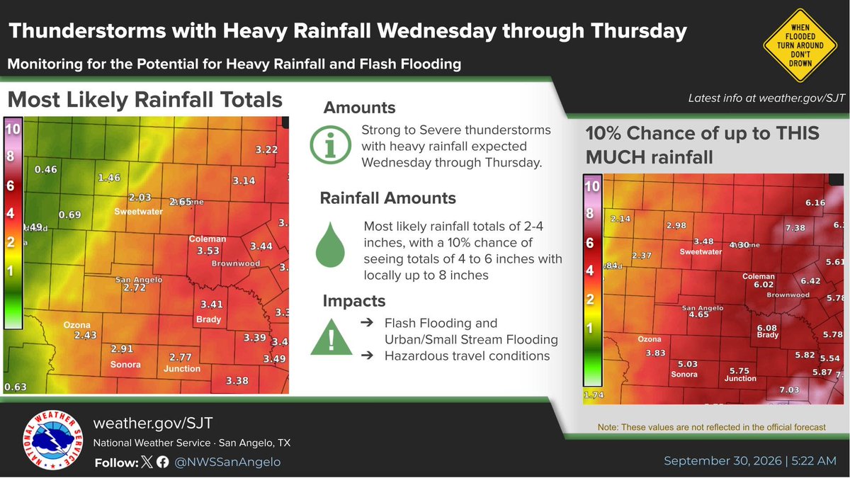
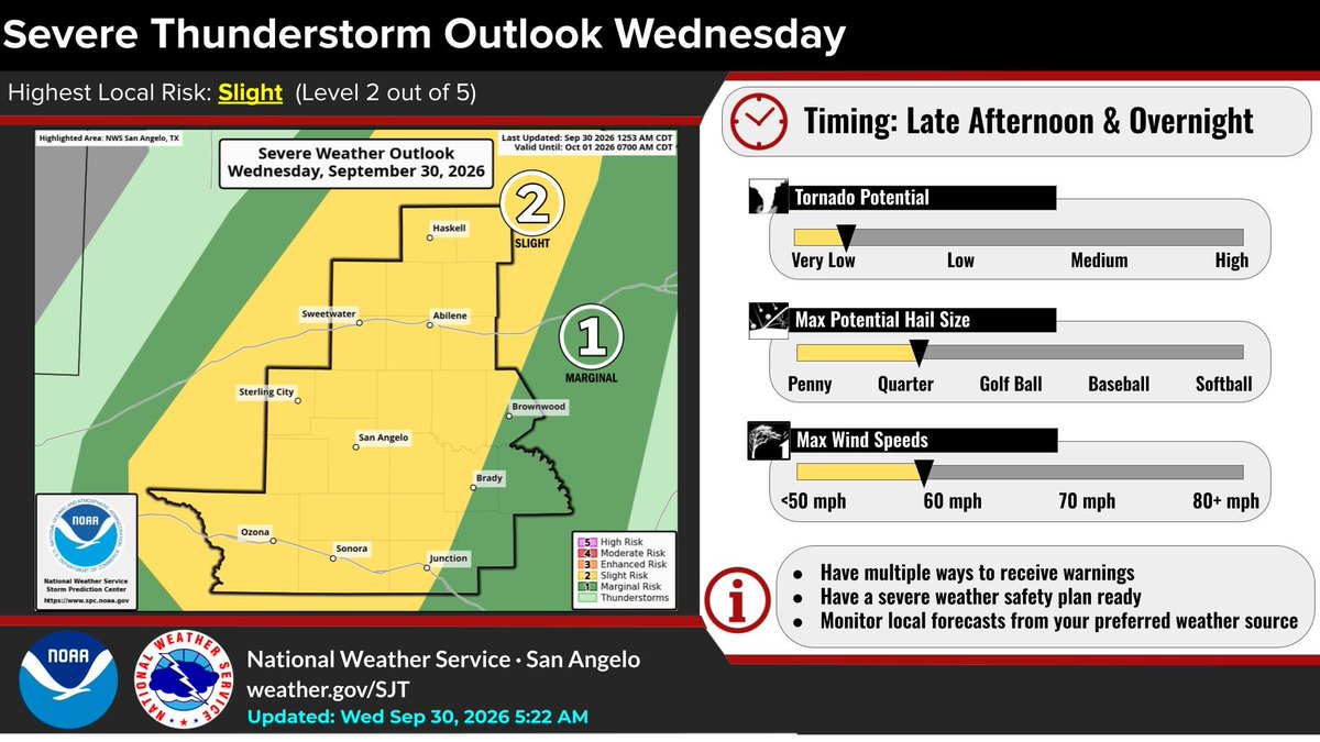
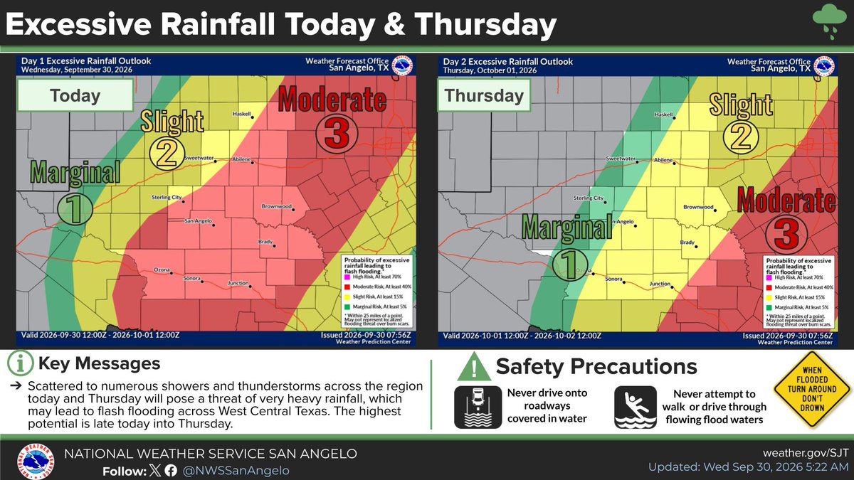
Heavy rainfall & flooding the main concerns as a slow moving line of storms develops and moves across the area late this afternoon and tonight. Severe risk is there as well, with hail up to a quarter & 60 mph winds possible. A very isolated tornado is also possible. #sjtwx#txwx
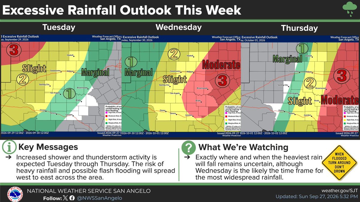
Rain's coming, y'all. Multiple rounds of it, moving west to east across Texas this week.
West Texas and the Panhandle get it first, Tuesday night into Wednesday. Then North Texas, the Big Country and the Hill Country on Wednesday, and right along I-35 on Thursday. Friday's still in play too.
Nearly everybody gets rain. Some spots could see 5 inches or more, but we don't know exactly where that heavy band sets up yet. Most of y'all won't flood. Some of us will have issues, especially Wednesday night through Friday.
And here's the part I've been waiting all fall to say: there's a real cold front behind it. Highs in the 70s and 80s for most of Texas by Friday.
Turn around, don't drown.
https://t.co/yCpNvoOVjI
We are becoming more concerned for the potential for locally heavy rainfall & flooding spreading across WC TX mid week. This comes from the combination of an upper level storm system moving into the area, a strong cold front, & Polo. Details/amounts still uncertain. #sjtwx#txwx
Hurricane Polo is about to become a Category 5 hurricane for the THIRD time...
Polo remains a Category 4 following an eyewall replacement cycle, but NOAA Hurricane Hunters found that the cycle is nearly complete and the storm is already showing signs of strengthening again.
Polo is forecast to regain Category 5 intensity tonight or Friday morning, potentially reaching 160 mph. If it does, this would mark the third separate time Polo has reached Category 5 strength during its lifetime.
Afterward, Polo is expected to gradually weaken as it turns northward toward the Baja California Peninsula, before moving inland across northwestern Mexico.
Meanwhile, moisture from Polo could spread well northward into the Southwestern U.S., potentially contributing to heavy rainfall and flash flooding this weekend and early next week.
Showers and thunderstorms are forecast to develop across the area this afternoon and into this evening. A few storms may become strong to severe, with strong gusty winds being the main concern. Heavy rainfall is possible which may result in minor flooding. #sjtwx#txwx#abiwx
8/25 430PM: The #RossFire has increased activity and is exhibiting extreme fire behavior. Air attack has placed a no-divert on aircraft due to a life-safety threat. This fire may move quickly, so if you're told to go, get out of dodge. Southerly winds will continue into tonight, so the fire may try to push farther north. -David
#RioEscondidoFire: 8/25 10AM: Road closures have been issued on CR 415 at HWY 281, CR 417 at HWY 281, CR 419 at HWY 281, and CR 4121 at HWY 281, Memory Ln at US 84, Ronnie Ave at HWY 281. HWY 281 and US84 remain open at this time.
Evacuations: Mandatory evacuations are in place From CR419 south to US84, and from HWY281 east to Cowhouse Creek. Voluntary evacuations are in place from CR411 south to CR415. Residents are not able to return to the mandatory evacuation area at this time, as conditions are still hazardous. A Red Cross shelter has been set up at the Evant school gymnasium with room for 50 individuals to be housed overnight.
WatchDuty is a good source to keep up to date, along with local emergency management and fire department accounts.