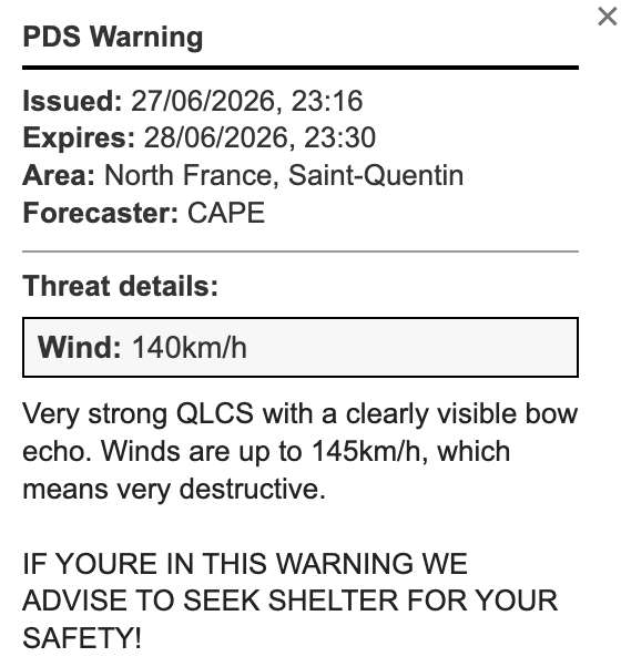
a strong QLCS with a clear Bow Echo is now moving through north France and later into Belgium. Few minutes ago radar indicated up to 140km/h.
This is a very dangerous storm.
@MateuszTaszarek this was my forecast for today. i was so confident i issued 6/6. if you want to read the really basic discussion you can read it here https://t.co/TZxnvuTt8j
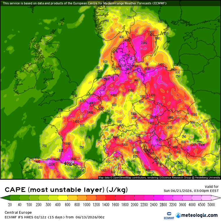
Moderate to Strong scattered thunderstorms are expected for Central Europe on 21st June 2026, with the highest risk being a MDRT.
MDRT
C-W Germany & W Czechia
Strong thunderstorms accompanied by very strong wind gusts and big hail are expected for both countries. Large storm system is expected to move from Germany to the Czech Republic by evening.
This day will be much different from yesterdays (20/06/26) scenario, as the storms will not be that scattered, but rather one single system.
ENHD
SE-N Hungary, E-C Slovakia & S Poland
Moderate thunderstorms are expected mostly all day in Slovakia, moving to Hungary during later hours of the day. These storms may bring heavy rain, and maybe even local floodings.
strong thunderstorms are expected for Central Europe on 20th June 2026, with the highest risk in the Czech Republic being a MDRT ##.
MDRT
C-W Czechia & N Austria Strong thunderstorms are expected for these two countries, but the main "show" will be happening in the Czech Republic, Bohemian Region. Models show high values of CIN (Convective Inhibition). this decreases the probability of thunderstorm initiation, but also increases the intensity of thunderstorms if they initiate (Loaded gun scenario).
##
C Bohemia The strongest thunderstorms of the day will be happening in this region, possibly hitting the capital city of the nation, Prague. The thunderstorms will carry large risk of large hail, severe to damaging wind gusts (up to 110km/h), local floods, and a slight chance of tornadoes. These thunderstorms may later form into an QLCS, which would enhance the probability of damaging wind gusts.
The main factor that is decreasing the confidence is the high CIN values in the region, but MDRT and ## show the intensity of thunderstorms if the particles will be able to break the cap
NEXT WEEKEND LOOKS INSANE!
next weekend looks like it will get bombarded by thunderstorms.
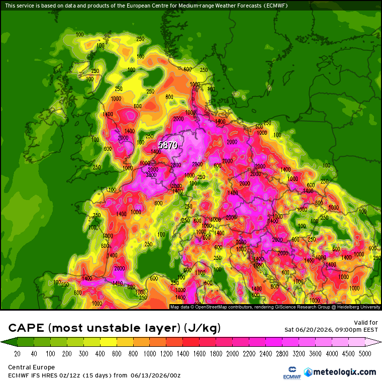
even though CAPE doesnt really tell us the probability of thunderstorms, but its a great indicator of where and how strong they could be.
Its still 7 days away, but models have shown it since wednesday, so the chance is very high.
In questo video, trovato da @Domenico199719, c'è l'unico plausibile tornado effettivamente documentato ieri nel veronese (e in tutto il nord a dire il vero)
Very strong to severe thunderstorms are expected for the Baltic region, for all countries, but the biggest threats are mainly for Lithuania and Latvia.
A strong pressure low is located exactly above the borders of Lithuania and Latvia, "sucking" all the warm moist air into it.
MDRT
C-N Lithuania, C-E Latvia & SE Estonia
Very strong thunderstorms are expected for this region, the main threats will be BIG HAIL, SEVERE WIND GUSTS, and possible TORNADOES.
##
Borders between C-N Lithuania and C-S Latvia
Severe thunderstorms with a very high probability of (strong) TORNADOES, LARGE HAIL, SEVERE WIND GUSTS. If storms really initiate in this area, the phenomena it brings will be very severe and potentially very dangerous for life.
@Djpuco@ynkyos@UsagiTor it could maybe be done in a way, that VOPs (or someone higher) would have to accept is as legitimate report, so the public reports, before being confirmed as legitimate, would be in a diffrent colour or style. this is just a quick solution i came up with now xd