Hurricane Erin Update (1/2)
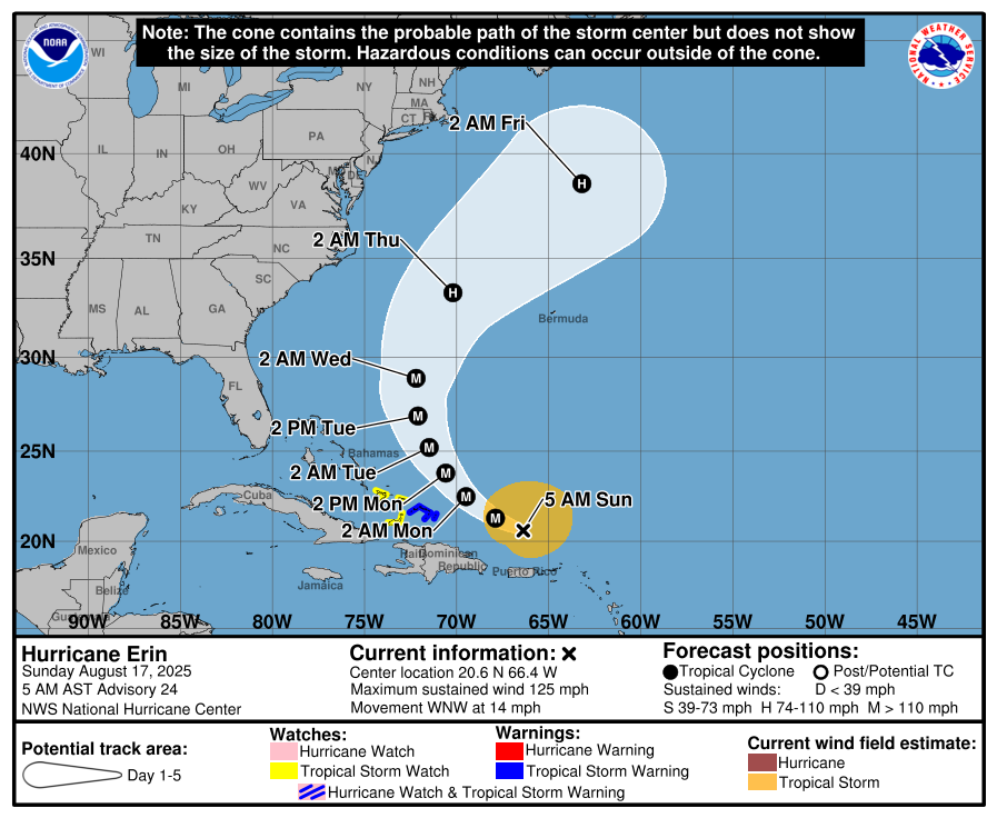
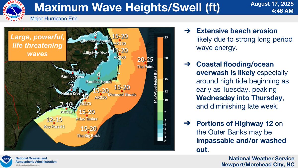
With a slight western shift in Erin's track overnight, forecast wave heights & wind speeds have increased, with TS force gusts possible along the OBX Wed night into Thurs. The risk of life threatening rip currents, damaging beach erosion, ....
Soggy weather makes a return with an inch or two of rain forecast through Monday. Areas inland are most likely to see their rain in the daytime hours, while those along the coast will likely be wetter overnight and early morning. Some isolated flooding is possible.
[6/28/25 6 AM]
Another hot summer day in store, with "feel like" temps peaking between 100-105F for much of ENC today. We could also see isolated to widely scattered tstorms, generally away from beaches, this afternoon and evening.
#ncwx#heat
[6/25/25 6:20 PM]
Another very hot day in store, with strong to severe t-storms possible this afternoon through the evening. Stay cool, have ways to receive warnings, and be #WeatherReady!
#ncwx#heat#thunderstorm
Mostly dry pleasant conditions are expected for most today, though an isolated storm is possible south of US 70. We quickly turn hotter tomorrow and for the majority of next week, with highs in the mid to upper 90s expected, and heat indices soaring to 105-110 degrees. #ncwx




![NWSMoreheadCity's tweet photo. [6/28/25 6 AM]
Another hot summer day in store, with "feel like" temps peaking between 100-105F for much of ENC today. We could also see isolated to widely scattered tstorms, generally away from beaches, this afternoon and evening.
#ncwx #heat https://t.co/X2Y3zMNPl9](https://pbs.twimg.com/media/GuhbgIlX0AAWq7E.jpg)
![NWSMoreheadCity's tweet photo. [6/28/25 6 AM]
Another hot summer day in store, with "feel like" temps peaking between 100-105F for much of ENC today. We could also see isolated to widely scattered tstorms, generally away from beaches, this afternoon and evening.
#ncwx #heat https://t.co/X2Y3zMNPl9](https://pbs.twimg.com/media/Guhbd09WAAA3UvA.jpg)
![NWSMoreheadCity's tweet photo. [6/25/25 6:20 PM]
Another very hot day in store, with strong to severe t-storms possible this afternoon through the evening. Stay cool, have ways to receive warnings, and be #WeatherReady!
#ncwx #heat #thunderstorm https://t.co/utzuk7oqlN](https://pbs.twimg.com/media/GuSDOa4W8AA6Zy4.jpg)
![NWSMoreheadCity's tweet photo. [6/25/25 6:20 PM]
Another very hot day in store, with strong to severe t-storms possible this afternoon through the evening. Stay cool, have ways to receive warnings, and be #WeatherReady!
#ncwx #heat #thunderstorm https://t.co/utzuk7oqlN](https://pbs.twimg.com/media/GuSC8KNWQAAnYdr.jpg)



![NWSMoreheadCity's tweet photo. [6/25/25 6:20 PM]
Another very hot day in store, with strong to severe t-storms possible this afternoon through the evening. Stay cool, have ways to receive warnings, and be #WeatherReady!
#ncwx #heat #thunderstorm https://t.co/utzuk7oqlN](https://pbs.twimg.com/media/GuSDSh0WQAADA6q.jpg)





