#TXWX Euro model of predicted rainfall accumulation from Monday morning 9/28 through to next weekend. Watch the path of Pacific hurricane Polo cut across the Baja, spreading heavy rains across much of the country.
National High/Low temps for Saturday September 26, 2026: 106 at 4 miles east of North Shore, CA, 16 miles southwest of Tecopa, CA; 22 at 19 miles east-southeast of Old Station, CA #cawx#cawx#cawx
Hi @NWSSanAntonio, A week or two ago now, I noticed that the information page for NOAA Weather Radio station WXK27 in Austin, as well as around 10 other stations in the US, are showing the wrong state. I have contacted the NWS by email but have not heard back.
Tropical Depression Five is currently in the Gulf, and is expected to move WNW into the Upper Texas coast, bringing increased moisture and rain chances to our E/SE counties late Tue-Thu. Rain totals of 0.25-1" are expected, though isolated totals may get up to 2". #ctxwx#txwx
The forecast changed. Tropical disturbance in the Gulf (Invest 97L) is better organized today, 125 mi south of SE Louisiana.
NHC: 50% in 48hrs, possible short-lived TD/TS before reaching the Upper TX coast Tue.
2-6" Houston to Beaumont Mon night-Wed.
https://t.co/fQOmOZFC4S
An upper level disturbance will bring a chance of storms through tonight. A few storms could produce some strong to severe wind gusts. Most locations will remain dry, however, with highs mainly in the triple digits and lows tonight in the mid 70s to mid 80s. #dfwwx#ctxwx
How Long are Above Normal Temps Expected Continue? Short answer: For at least the next couple weeks. Long answer: Above normal temperatures likely to continue through the end of the month w/ equal chances of above and below-normal temperatures in the first half of August.
215 PM: While rainfall continues across western Central Texas, a northward moving outflow boundary will help kick off showers & storms farther north, as it moves through the I-20 corridor during peak heating hours. Gusty winds & heavy rain may accompany some storms. #ctxwx#dfwwx
A NOAA All Hazard Weather Radio is an essential home investment!
✅ 24/7 Direct Alerts from the NWS
✅ Outage Ready: Runs on battery, solar, or hand-crank
✅ Nighttime Protection: Alarms wake you for tornadoes & flash floods!
https://t.co/4DVTJ4Xzc1
#TXFloodAwarenessWeek#txwx
SPC has outlined an Enhanced Risk (level 3/5) tomorrow (Sunday, May 10) across northern/central Texas. Widespread convection is expected to develop along a southward-sagging cold front across the area by early afternoon. Initially, more discrete storms will pose a risk for very large hail before the damaging wind threat takes over as storms quickly congeal into an intense squall line. Wind gusts in excess of hurricane force (74 mph) are possible.
Hi @NWSFortWorth, there's a really loud buzzing sound on radio station KEC55 in Fort Worth. Sounds like someone's trying to microwave a burrito on the transmitter lol. Just wanted to make y'all aware of this with the storms coming tomorrow.
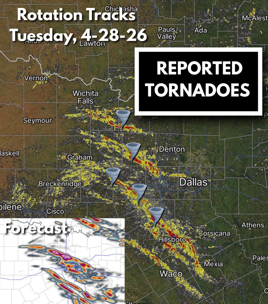
The DFW metroplex dodged a massive, massive bullet yesterday. 25 miles east like forecasted and we would’ve had an even more tragic situation than we ended up with.
For everyone that was mad “we didn’t get anything in dfw “ yesterday - this is how close it was. Little changes to how storms “initiate” can’t be forecast. You can only watch how they evolve. Metroplex was close to getting softball hail and tornadoes. Can only prepare.
SATURDAY APRIL 25 2026 TORNADOES: We have confirmed two additional tornadoes in Jack County from Saturday's severe storms, bringing the total to 4:
EF0 north of Jacksboro (Jack Co.)
EF1 northeast of Jacksboro (Jack Co.)
EF2 Runaway Bay (Wise Co.)
EF1 Springtown (Parker Co.)
Another chance of severe weather today, folks. Yesterday was a good reminder that even a small chance of severe weather can really pack a punch, and ultimately prove to be deadly. Please stay alert this afternoon and evening.