7 AM ET 6/3 - With the region now behind the cold front we can finally enjoy a couple dry days of lower humidity and pleasant temperatures. 😃☀️
Unfortunately, it will be short lived as our temps begin to climb back up beginning tomorrow with rain chances returning this weekend.
Thunderstorms with large hail, severe wind gusts and potentially a couple of tornadoes are expected this afternoon and evening in parts of the northern Plains. Strong wind gusts and marginal hail will also be possible in parts of the southern and central High Plains. A few severe wind gusts may also occur from southern Georgia into northern and eastern Florida.
6/1/26 656PM CT 📡 ⛈️ ⚠️ 🌬️
Severe thunderstorms plowing thru SE AL and parts of adjacent SW GA have a history of downed trees/powerlines with gusts well over 40 mph common. The FL Panhandle is up next near the AL border as storm outflows collide. #FLwx#GAwx#ALwx
7 AM ET 5/31 - Excessive Rainfall is possible today as activity is expected to be the most active today out of the last few days.
Generally, widespread half an inch to 1.5 inches expected. Isolated higher amounts up to 5 inches possible, across SW GA, SE AL & FL State Line. 🌧️⛈️
#WPC_MD 0286 affecting southern Georgia, far north Florida, far southern South Carolina, and southeast Alabama, #scwx#gawx#flwx#alwx, https://t.co/cJJ0lJALna
Houston County road and bridge
Please be advised that Hilltop Road is now closed to through traffic between AL Hwy 92 and Judge Logue Road until further notice.
5/8, 615 am ET: There's a Marginal Risk (Level 1 of 5) of severe thunderstorms each day through Sunday. Be ready to head indoors when storms approach. Main threats are strong gusts, lightning, torrential downpours, and hail. #FLwx#GAwx#ALwx
Houston County road and bridge
Please be advised that George Road is now closed to through traffic between Harper Joy Rd and Hooper Cherry Road until further notice.
The National Weather Service has issued a Marginal Risk of Severe Weather Thursday
There is a marginal risk (Level 1 of 5) of severe weather across portions of the Florida panhandle, southeast Alabama, and southwest Georgia during the day on Thursday.
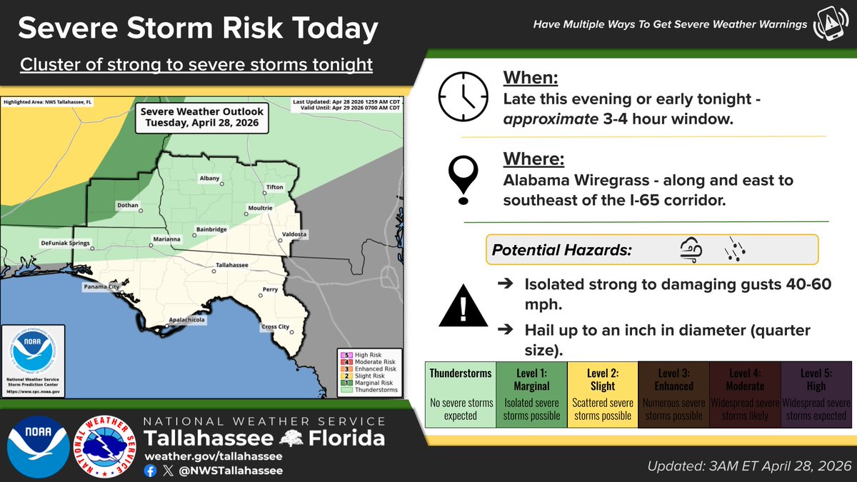
4/28/26 8AM ET ⛈️⚠️
Isolated strong-severe storms are possible tonight (storm cluster) & Wed night (cold front).
Where: SE AL, parts of the FL Panhandle. 📍
Main threats: strong-damaging gusts, hail. 🌬️🧊
Additional severe wx is on tap for us on Sat. 🔮
#FLwx#GAwx#ALwx