Heat will be a big issue this week, but we still have one more day where heavy rain could threaten areas already hit by flooding. Here's more in your Storm Station Video Extra.
Dangerous heat and flooding rainfall are both concerns this weekend. A Heat Advisory is in effect today, and scattered storms could produce heavy downpours, localized flooding, and a few strong wind gusts.
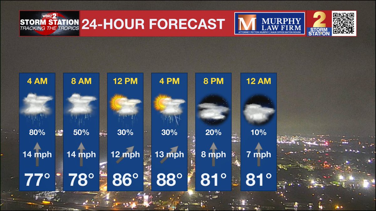
Click for a breakdown of the forecast --->
https://t.co/B9jKrg8U9L
The remnants of Arthur are over the southeast U.S. Lots of tropical moisture remains in place locally keeping heavy downpours possible. The rest of the Atlantic Basin is quiet.
Click for Let's Talk Tropics!
https://t.co/cNhPVC7MuA
Coverage of rain will be less today and Saturday, but the potential heavy downpours continues. Remember, some folks saw over 20 inches of rain Thursday. Storms today will still be capable of producing several inches of rain. Let's hope it doesn't fall in areas already hit hard.
Much of Acadiana didn't get the massive rain that was forecast, but much of the state did. Red over CenLa and SELA is over 15 inches of rain. The pinks in St. Landry and Avoyelles are over 20..and much of that fell on Thursday alone. Count your blessings. 5 day totals.
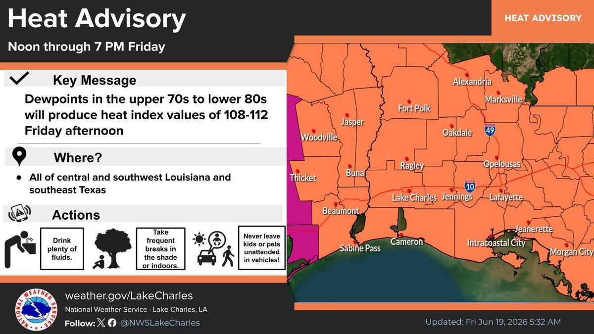
High humidity and hotter temperatures will combine to create dangerous heat index values. A Heat Advisory is in effect today, and likely will continue this weekend.
Very humid again with scattered showers and storms developing. Some heavy downpours can be expected again. High humidity will kick the heat index over 108 this weekend keeping a Heat Advisory in place.
Click for Acadiana Weather Today! https://t.co/UDWiodR1hk
Arthur has dissipated, but remnant moisture will still keep a flood threat over parts of the Gulf coast. The rest of the Atlantic basin is quiet, and we may be heading into a lull in the season for a few weeks.
Let's Talk Tropics!
https://t.co/2RXuUZJTY9
The heavy rain threat continues, but conditions will improve later this afternoon. The heat returns for Father's Day weekend. Click for more in your Storm Station Video Extra.
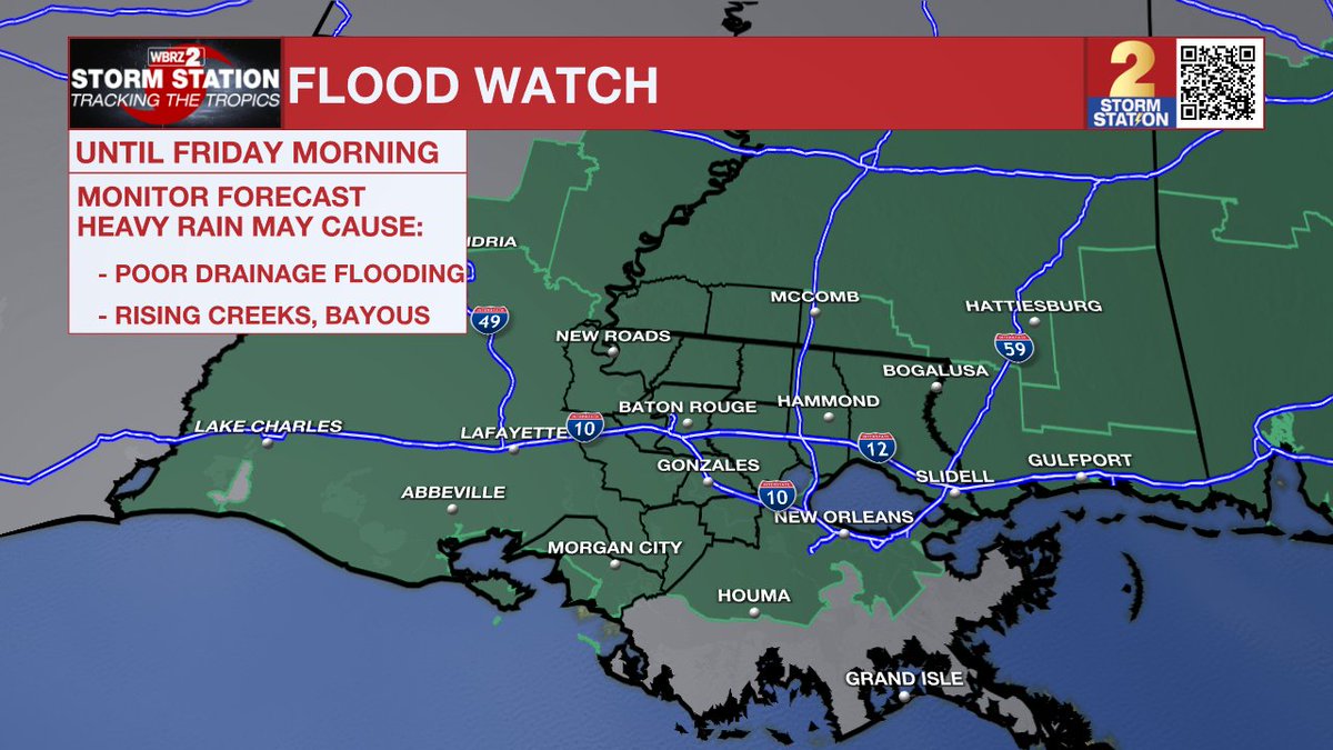
The Flood Watch continues. Some areas have seen over a foot of rain over the past 3 days. Any additional rainfall could cause flooding. Don't drive through high water!
Some locations could see several more inches of rain before conditions gradually improve. Once the rain moves out, dangerous heat quickly returns. Stay weather-aware today and never drive through flooded roads.
Click for a breakdown of the forecast --->
https://t.co/5njhnyB9Co
The remnants of Arthur will keep rain in the forecast. Some heavy rain is possible this morning over eastern areas. Improving weather for the Father's Day weekend.
Acadiana Weather Today!
https://t.co/T4vjWziiPl
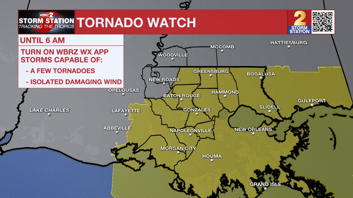
A Tornado WATCH remains in effect until 6am for much of the Capital area. A Flood WATCH also remains in effect until early Friday. Arthur has moved inland and dissipated, but the flood threat remains. Some improvement later this afternoon.
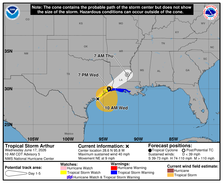
Tropical Storm Arthur has formed in the western Gulf. Winds 40mph. Arthur is a rain maker, with coastal flooding. Inland heavy rain is likely through Thursday with improving conditions this weekend. More in today's
Let's Talk Tropics! Click below. https://t.co/DejlbGn8Nh
Radar 9am: A lot of rain in the offshore waters near PTC #1. This will move onshore later this afternoon with heavy rain likely late today and tonight. The next update on PTC #1 is at 10am.