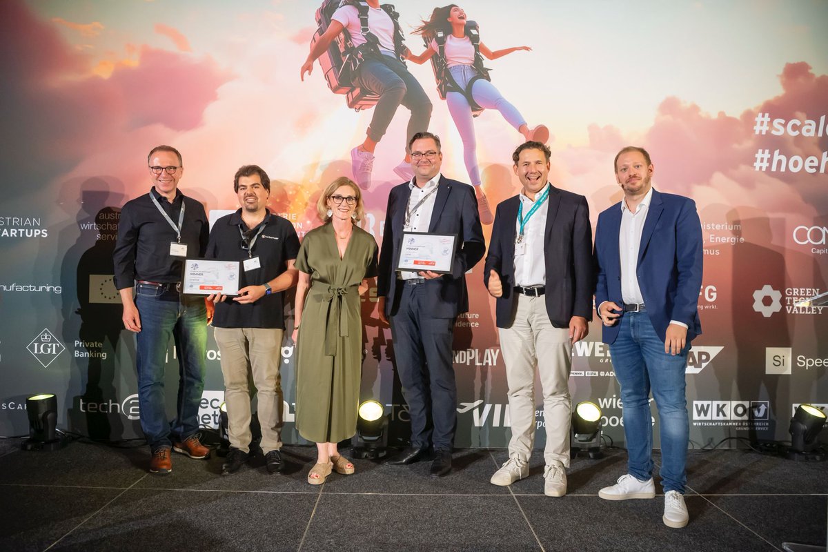
Last Wednesday, from over 250 submissions, Austria’s most successful scale-ups and the next rising stars were honoured. We are proud to have won the @EYnews award again in 2025 in the "SpaceTech & Aviation" category!
"To be recognised by the board of 70 judges from more than 250 start-ups is a great honour and a valuable recognition for the achievements of our entire team. The timing couldn't be better for us, as we just recently launched our new solution hashtag#NavSentry, focusing on advanced GNSS threat detection and prevention for securing critical operations," says @ThomasNeubauer_ _, our Co-Founder and CEO.
More about the award here:
https://t.co/iGt04Ufugo
Today at the International Drone Show 2026, our Project Director Gorazd Mirkovski took the stage as a panelist in “Beyond U-Space – Enabling Safe and Scalable BVLOS Operations”, joining Ludovic Lang, Director, Global Head of Digital Aviation & UTM at @ThalesAerospace, and Mathias Lieblein Rørbæk Vinter, Head of Drone Excellence at DSV - Global Transport and Logistics, in a discussion moderated by Richard Boden, Acting COO at @murzilliconsult.
The session explored a key industry question: what does it actually take to make #BVLOS #drone operations safe, scalable, and economically viable?
Topics included:
• Practical approaches to BVLOS deployment beyond U-Space environments
• The infrastructure and safety services required for reliable operations
• The role of #connectivity, situational awareness, and operational intelligence
• Balancing #regulatory requirements with commercial scalability
At Dimetor, we see every day that successful BVLOS drone operations depend on more than #aircraft capabilities alone. They require trusted information about connectivity, positioning integrity, and the operational environment.
If you're attending the International Drone Show and would like to discuss how #AirborneRF, #NAVSentry, and #AirborneAI support safe and scalable drone operations, Gorazd is available throughout the event for conversations and meetings.
We’re proud to announce that #Dimetor has been selected for the DTM Watchlist at Deep Tech Momentum 2026, recognising us as one of the Top Early-Stage Deep #Tech Startups in #Europe.
Taking place on 20–21 May 2026 at Wilhelm Studios #Berlin, Deep Tech Momentum is Europe’s leading marketplace for deep tech, AI, defence, #space, and high-performance computing innovation.
At #DTM26, the Dimetor team will be there to discuss how #telecom infrastructure is becoming a critical operational layer for modern #aviation, #autonomy, and #defence applications.
Our focus areas include:
• #AirborneRF for telecom-powered airspace intelligence and awareness of BVLOS drone operations
• #NAVSentry for real-time GNSS jamming and spoofing detection using telecom networks as distributed sensors
• #AirborneAI for detecting and localising cellular-connected #drones in complex environments
• Dual-use telecom capabilities for resilient #airspace operations across civil and defence domains
As aviation, #AI, autonomy, and defence increasingly converge, operational intelligence from telecom networks is becoming essential for safe, scalable, and resilient airspace systems.
Looking forward to connecting with innovators, investors, and partners driving the next generation of European deep tech in Berlin.
“When all infrastructure is under attack, can mobile #networks still be trusted?”
This was the question raised by Bernhards Blumbergs, Lead Cybersecurity Expert at @certlv , during the latest @Techritory Forum “Game of Drones” podcast, where Gorazd Mirkovski, Project Director at Dimetor, shared his perspective on #connectivity resilience in conflict scenarios.
Gozard explained that relying solely on dedicated military #RFsystems is risky, as they can be easily detected and targeted. Public #4G and #5G networks are harder to distinguish for civilian or military use, increasing overall resilience under pressure. Being the most reliable approach to interwork private 5G networks with public cellular infrastructure, combining operational control with the robustness and scale of civilian networks.
Dimetor’s solutions make hybrid connectivity visible, measurable, and actionable in real time:
- NAVSentry monitors #GNSS integrity and detects jamming and spoofing, providing real-time alerts to protect navigation and timing.
- #AirborneRF delivers live #cellular connectivity intelligence, showing where 4G and 5G networks can reliably support airborne operations and where risks may occur.
- AirborneAI applies advanced analytics to interpret connectivity and signal #data, enabling anomaly detection and performance forecasting to support informed operational decisions.
- Together, these solutions help organisations manage connectivity risks, giving operators confidence to carry out critical missions in contested environments.
Watch the full panel discussion here: https://t.co/E7XyK51uiG
According to a recent Research And Markets report, #GNSS augmentation is becoming a critical enabler for #aviation, maritime operations, #autonomous systems, and high-accuracy #drone missions, with the global market expected to surpass $20 billion by 2030.
As reliance on GNSS continues to grow, operational challenges become increasingly evident:
- Signal degradation, jamming and spoofing impacting positioning, navigation and timing
- Rising accuracy and integrity requirements for #BVLOS drone operations and autonomous operations
- The need for real-time correction, continuous monitoring and resilient positioning architectures
To address these challenges, Dimetor delivers airspace intelligence that enables safe and resilient operations. #NAVSentry provides real-time #GNSS integrity monitoring to detect and localize jamming and spoofing events. #AirborneRF delivers live #connectivity intelligence and cellular coverage insights across 4G and 5G networks, supporting reliable command-and-control planning and execution. #AirborneAI adds AI-driven analytics and operational intelligence, enabling anomaly detection and situational awareness across complex airspace environments, including #BVLOS drone operations and GNSS-degraded scenarios.
Together, these solutions turn operational resilience into a built-in capability rather than a reactive measure.
Learn how Dimetor supports safe, scalable and future-proof operations here: https://t.co/UCbwX8mHyQ
Europe’s #BVLOS drone operations landscape is evolving rapidly, but U-space is not always the answer.
As drone operations expand across maritime, rural, and industrial environments, a key question emerges: where can safe and scalable BVLOS drone operations be enabled without full U-space integration?
At the International Drone Show 2026 in Odense (June 3–4), our co-founder and CEO Thomas Neubauer will join a high-level panel to explore exactly this.
Panel: Beyond U-Space – Enabling Safe and Scalable BVLOS Operations
June 4, 09:35–10:25
Thomas will be speaking alongside leading industry experts:
Ludovic Lang, Global Head of Digital Aviation & UTM, Thales
Mathias Lieblein Rørbæk Vinter, Head of Drone Excellence, DSV - Global Transport and Logistics
Quantum Systems
Moderated by Christoph Schlettig Schlettig, CEO & Founder, Unisphere
The discussion will focus on:
• Where BVLOS drone operations can be safely deployed without U-Space
• The limits of current frameworks and regulatory approaches
• The minimum set of technologies, services, and infrastructure required for safe and scalable operations
Because enabling BVLOS drone operations at scale is not just about regulation but having the right operational intelligence and infrastructure in place.
If you’re attending, don’t miss the session.
Learn more about the event: https://t.co/sCECTeZTpN
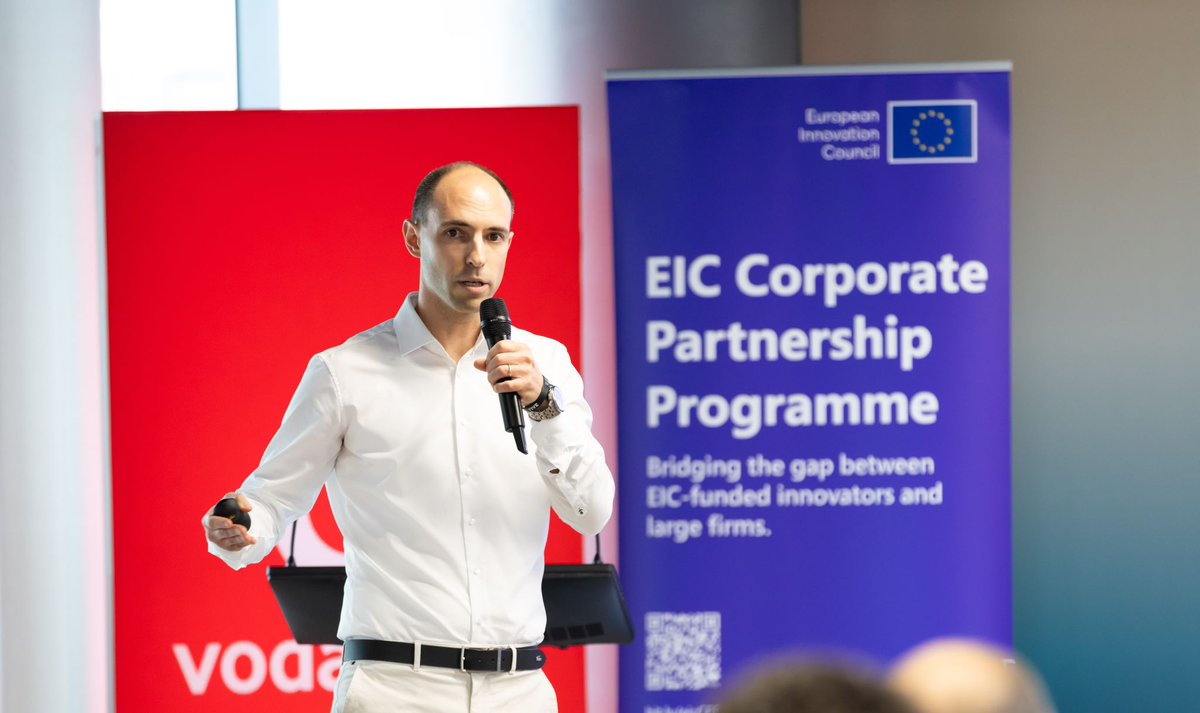
A big thank you to the EIC - European Innovation Council for bringing together such a strong group of #innovators and industry leaders at the Multi Corporate Day in #Bucharest.
We’re proud that Dimetor was selected as one of the EIC-backed start-ups to engage with partners such as @vodafonebuzz and PPC Romania, contributing to discussions on the future of #connectivity, #infrastructure, and #innovation.
At Dimetor, we go beyond enabling scalable #drone operations; we build the foundation for safe, data-driven #airspace that can support them.
By leveraging #telecom infrastructure, we enable mobile network operators to play a central role in this developing ecosystem, unlocking new capabilities through:
• AirborneRF for airspace connectivity intelligence
• NAVSentry for GNSS resilience and interference detection
• AirborneAI for detecting cellular-connected drones
Looking forward to continuing the conversations and turning these connections into real-world impact.
Read the full highlights here: https://t.co/0cT8dlXOe0
“You need to look at airspace holistically to understand who are the friends, the foes, and the fools.” said @ThomasNeubauer_ , CEO of Dimetor
In the latest episode of @GlobalAirspaceR , Thomas Neubauer joined @vlambercy to discuss one of the most important shifts in #aviation and #defence today: #drone detection is evolving from physical sensing to signal intelligence.
The conversation covers several critical topics shaping the future of #airspace:
• The growing role of #telecom networks as digital infrastructure for #BVLOS drone operations
• The challenge of detecting drones that use 4G/5G #connectivity and blend into normal network traffic
• Why multi-sensor fusion remains essential, combining radar, RF, optical, and now cellular intelligence
• The rise of hybrid threats, where drones exploit civilian infrastructure such as mobile networks
• The need for wide-area airspace monitoring, beyond point protection of strategic locations
A key takeaway is clear: the “cellular gate” in airspace monitoring is still largely open and must be closed.
The discussion also highlights a critical reality: #GNSS interference is no longer limited to conflict zones. From criminal activity to everyday misuse, disruptions can occur anywhere and often without immediate visibility.
As drone operations scale and threats evolve, airspace security must extend beyond what can be physically seen and include real-time intelligence from the signal layer.
Listen to the full episode here: https://t.co/zuKdDCMbet
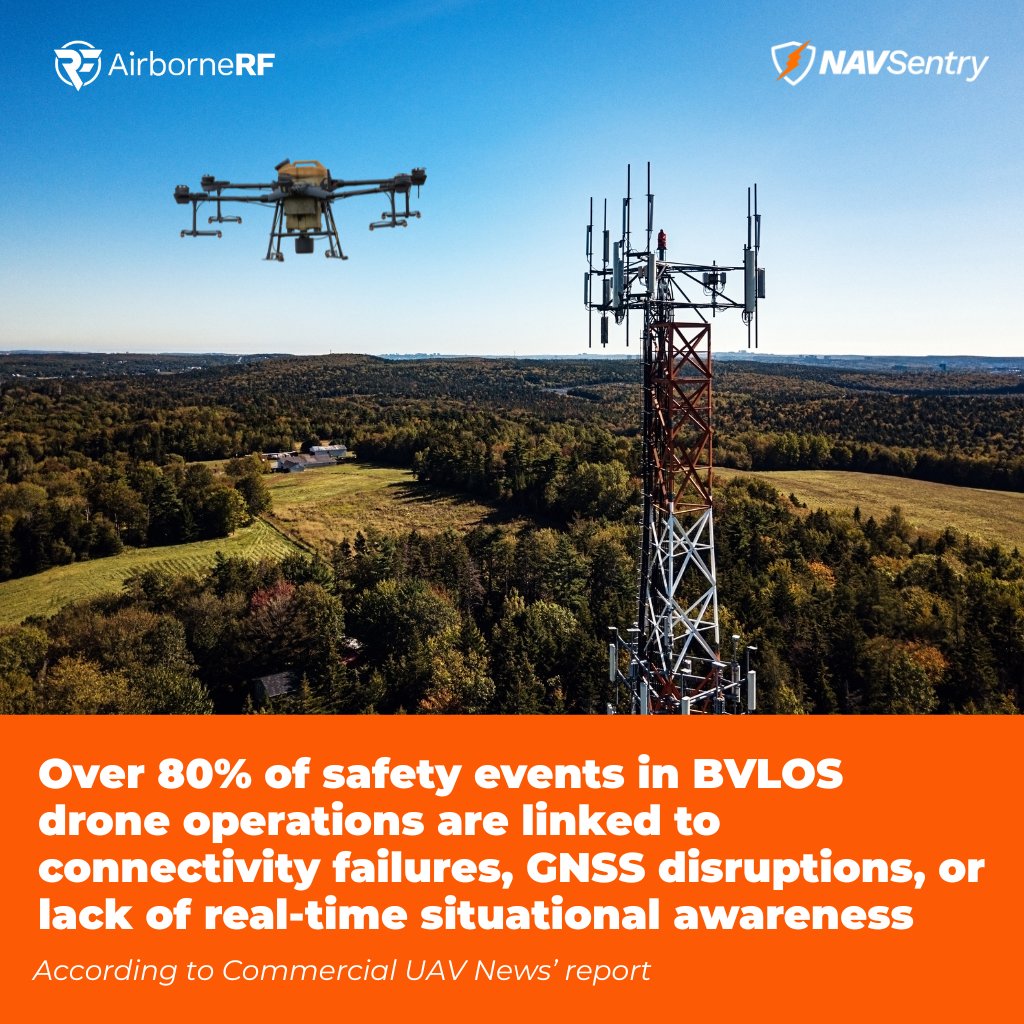
Based on a recent report from @ExpoUAV , industry estimates suggest that more than 80% of safety events in #BVLOS#drone operations are linked to communication failures, #GNSS disruptions, or insufficient real-time situational awareness. As drone operations scale globally, traditional tools alone are no longer sufficient.
As highlighted in the report, discussing the @FAANews upcoming Part 108 framework, aviation regulation is entering a new phase where #data systems and digital infrastructure become part of the safety case itself.
Capabilities such as detect-and-avoid (#DAA), command-and-control (#C2), positioning integrity, remote operations, and automation logic are now key elements of safe #BVLOS drone operations.
This shift requires resilient, data-driven systems that provide operational visibility into connectivity, positioning, and airspace conditions.
#Dimetor contributes to this evolving safety architecture through enabling AI-driven situational awareness and detection of non-cooperative drones, supporting operational decision-making while maintaining human-in-the-loop control and providing real-time connectivity intelligence, C2 reliability insights, and airspace risk awareness derived from telecom networks.
As regulatory frameworks evolve, connectivity, positioning integrity, and real-time intelligence are becoming core operational parameters, not optional add-ons.
Explore how Dimetor supports next-generation airspace operations: https://t.co/Fzk0VmdZRO
According to @PwC’s report “Advanced Air Mobility: From Concept to Commercial Reality”, more than 1,100 #eVTOL aircraft concepts have already been developed by 450+ companies worldwide. This level of activity highlights a global shift toward new transportation models, urban air taxis, regional point-to-point routes, and increasingly autonomous heavy-lift cargo operations.
As #airlines and #airports prepare for this transformation, one challenge consistently stands out: #AAM can only scale if #connectivity, situational awareness, and airspace integration are reliable from day one.
This is where Dimetor’s solutions directly support the transition from concept to commercial reality:
- AirborneRF provides the telecom-aviation #data exchange needed to plan, assess, and approve safe AAM flight corridors, ensuring eVTOLs stay connected throughout all phases of flight.
- #NAVSentry delivers continuous monitoring of GNSS integrity, detecting interference, spoofing, and jamming in real time, an essential capability for automated and #BVLOS operations in dense urban environments.
Together, these platforms enable airports, vertiports, regulators, and operators to build scalable, data-driven AAM ecosystems that meet regulatory expectations and operational safety requirements such as SORA, U-space, and Remote ID.
The AAM market is projected to grow from $11.4B in 2024 to $87.8B by 2034, but only with the right digital infrastructure in place.
At Dimetor, we’re committed to supporting this growth with telecom-powered intelligence that strengthens safety, connectivity, and operational resilience for the next generation of air mobility.
You can read the full report below.
https://t.co/Sfc1yI4Fus
The latest U.S. Drone Market Trends Analysis Report (2025–2030) by Research and Markets points to a key transformation: the drone industry is shifting from hardware-driven growth to data-driven, autonomous, and #BVLOS-enabled drone operations.
With the market expected to grow from $28.4B in 2025 to $52.5B by 2030, several forces are driving adoption:
- AI-powered autonomy and predictive analytics
- A rapid rise in #Drone-as-a-Service business models
- Expansion of #BVLOS drone operations beyond waiver systems
- Hybrid truck-and-drone #delivery frameworks
- Eco-focused drone missions supporting ESG goals
- Increasing demand for counter-#UAS and #airspace protection
For the market to scale safely, #connectivity and airspace intelligence will be decisive. This is where Dimetor’s solutions, #ArborneAI, #AirborneRF and #NAVSentry, directly align with the market’s direction.
#AirborneRF enables secure, aviation-grade #data exchange between #telecom networks, #UTM/ATM ecosystems, and operators.
#NAVSentry strengthens the other side of the equation: #GNSS security. As autonomy and AI-driven navigation increase, so does the need for real-time detection of #jamming, spoofing, and interference across national airspace.
#AirborneAI detects signal patterns at altitudes, distinguishes them from legitimate users and provides real-time detection, localisation, and characterisation of rogue drones.
Together, these capabilities address the core requirements highlighted in the report:
- reliable connectivity
- resilient navigation
- predictive risk analytics
- scalable BVLOS drone operations
- airspace safety and compliance
As the drone market enters its next growth phase, aviation will depend on the digital infrastructure that makes automation safe, compliant, and scalable. And that infrastructure is exactly what we build.
For more information, visit our website.
Dimetor partners with ESA NAVISP for Large‑Scale #GNSS Interference
Dimetor has launched a groundbreaking new project in partnership with the European Space Agency (ESA) to deliver large‑scale, real‑time detection and localisation of #GNSS interference. This initiative leverages dense #telecom infrastructure as a distributed sensor network, enabling rapid identification of jamming, spoofing, and other disruptions that threaten satellite‑based navigation. The project is supported through ESA’s NAVISP program Element 2.
For more information about the project, visit our website: https://t.co/eDcEolqGRz
XPONENTIAL Europe confirmed one thing clearly: #telecom is a core layer of #airspace operations.
Together with our partner @VodafoneGroup, #Dimetor showcased how telecom #data is already enabling safe, scalable, and resilient #drone and #aviation operations across commercial and defence environments.
Three key takeaways from the event:
➡️ #BVLOS #drone operations require digital airspace intelligence
Safe scaling depends on understanding #connectivity and ground risk in real time. A digital twin of the airspace is essential to assess availability, performance, and operational constraints before and during flight.
➡️ #GNSS integrity must be continuously monitored
With #GNSS increasingly exposed to jamming and spoofing, telecom networks act as a distributed sensor layer to detect interference and provide real-time #PNT situational awareness.
➡️ #Airspace #defence must go beyond point solutions
Effective counter-drone strategies require continuous, wide-area monitoring, including the ability to detect and track non-cooperative drones through cellular network intelligence.
Demonstrating these dual-use capabilities live with Vodafone showed what is already possible today and the level of demand across both commercial and defence stakeholders.
If you want to continue the conversation or explore collaboration opportunities, feel free to reach out.
At XPONENTIAL Europe, Dimetor and High Lander signed a Strategic Cooperation Agreement, expanding our collaboration to integrate #telecom intelligence as a core component of #UTM and #airspace management.
This partnership moves beyond #connectivity as a supporting layer, positioning it as a critical operational input for safe, data-driven #BVLOS #drone operations.
By combining High Lander’s Vega UTM platform with Dimetor’s intelligence layers, the collaboration delivers:
• #AirborneRF: real-time connectivity intelligence, 3D coverage awareness, and ground-risk data
• #NAVSentry: detection of GNSS jamming and spoofing to ensure PNT integrity
• #AirborneAI: identification and tracking of non-cooperative drones via cellular networks
Together, these capabilities enable enhanced situational awareness, resilient operations, and safer airspace coordination, addressing both operational complexity and emerging risks in increasingly dense environments.
As drone operations scale globally, reliable connectivity, positioning integrity, and real-time intelligence are becoming prerequisites for deployment, not optional features.
Learn more about the partnership and what it enables in our blog: https://t.co/92DtIwhktG
Thomas Neubauer, Co-founder & CEO of #Dimetor, will speak at Xponential Europe this March in Düsseldorf on:
“Securing Autonomous Operations: Dual-Use Lessons from Civil and #Military Domains”
Civil and military #drone operations are increasingly using the same #airspace, networks, and navigation systems. This convergence introduces shared risks around #connectivity, #GNSS integrity, and operational resilience, particularly for #BVLOS drone operations and #autonomous missions.
In this session, Thomas will speak about:
- Practical lessons from civil and defense deployments
- How #AirborneRF supports BVLOS drone operations with live cellular connectivity and population-density intelligence
- How #NAVSentry detects and localizes #GNSS jamming and spoofing to protect PNT integrity
- Why cloud-native, #AI-assisted platforms are becoming a requirement for scalable, compliant autonomous operations
The talk focuses on operational realities, regulatory constraints, and dual-use system design, relevant to #aviation authorities, defense organizations, #telecom operators, and #UAS service providers.
Attend on site to hear concrete implementation insights and deployment experience.
More information about the event: https://t.co/VTzUD7yL13
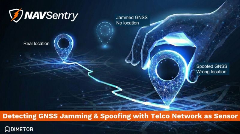
Dimetor is exhibiting at XPONENTIAL Europe to demonstrate how #GNSS interference, such as jamming and spoofing can be detected and monitored by using #cellular networks as a massive, real‑time sensor system.
By combining #telecom network infrastructure and Dimetor’s #NAVSentry technology, Dimetor is showcasing a breakthrough approach to safeguarding Positioning, Navigation and Timing (#PNT) services.
Why this matters today?
- Civil resilience: Modern #mobility, #logistics, emergency response, and critical infrastructure all depend on reliable GNSS signals. Interference, whether accidental or intentional, can disrupt transportation networks, delay supply chains, and compromise public safety.
- #Defense readiness: Jamming and spoofing are increasingly used in hybrid and electronic warfare. Early detection and wide‑area situational awareness are essential to protect national security assets and ensure operational continuity.
- Nationwide coverage: Traditional GNSS monitoring relies on isolated sensors. #MNO network scale enables continuous, country‑wide visibility, providing early warnings and actionable intelligence.
- Trusted innovation: Dimetor’s interference‑intelligence technology creates a powerful, future‑proof capability for securing Europe’s digital and autonomous ecosystem.
At XPONENTIAL Europe, #Dimetor will show how network‑powered sensing can protect both civilian life and national defense in an era where GNSS integrity has never been more critical.
Visit us at XPONENTIAL Europe – @vodafone booth, Hall 1, Stand C35
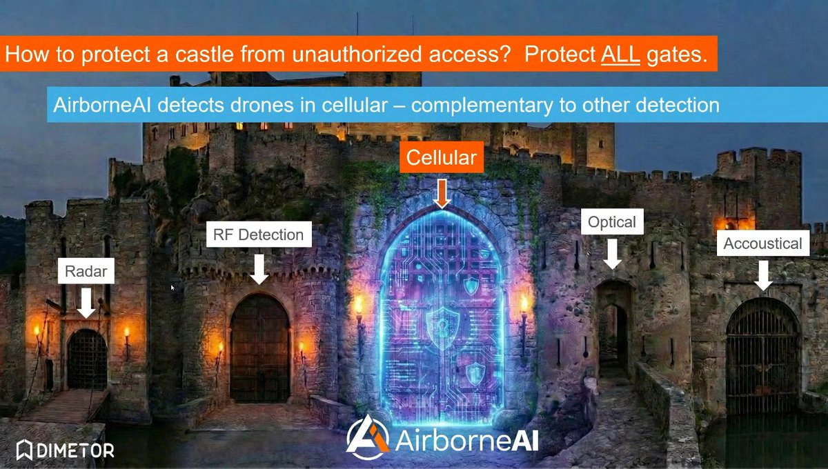
How do you protect airspace from unauthorized #drones? You protect all detection layers.
Modern counter-drone systems rely on multiple sensing technologies: #radar, RF #sensors, optical systems, and acoustic detection. Each provides valuable information, but each also has limitations depending on environment, terrain, or #drone type.
This is where cellular networks add a critical additional layer.
With #AirborneAI, Dimetor enables rogue #drone detection through cellular #connectivity, complementing traditional sensor technologies and strengthening situational awareness across protected areas.
By leveraging existing #telecom infrastructure as a large-scale sensing network, #AirborneAI can support:
- Identification of airborne devices connected to cellular networks
- Localization of non-cooperative drones
- Friend-or-foe differentiation in complex environments
- Integration into multi-sensor detection architectures
The result: a more resilient and comprehensive #airspace protection strategy.
Just like securing a castle requires protecting every gate, airspace security depends on combining multiple detection layers, including cellular intelligence.
Learn more about AirborneAI: https://t.co/Fzk0VmdZRO
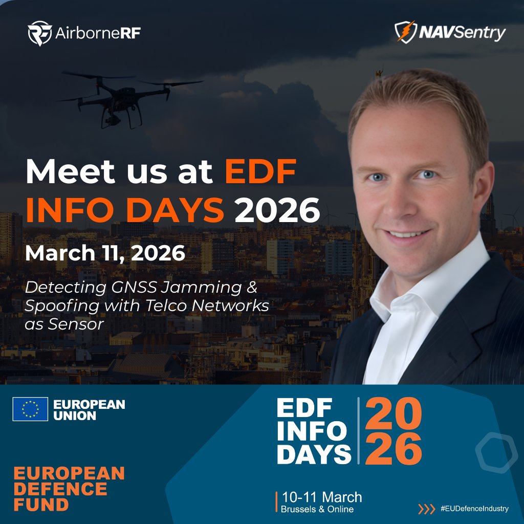
Dimetor has been selected to present at the European Defence Fund (EDF) Info Days 2026 with the topic: “Detecting GNSS Jamming & Spoofing with Telco Networks as Sensor.”
Organised by the European Commission’s DG DEFIS, the event brings together key stakeholders across EU defence innovation, R&D, and capability development.
On March 11, in Brussels, Thomas Neubauer, CEO & co-founder of Dimetor, will demonstrate how #telecom networks can act as large-scale, real-time sensor infrastructure to support #GNSS integrity, airspace security, and #defence operations.
As autonomous systems and connected assets scale, understanding #connectivity, positioning reliability, and interference in real time is becoming operationally critical.
At EDF Info Days, Dimetor will showcase:
#NAVSentry: detection and localisation of GNSS jamming and spoofing, enabling real-time PNT integrity monitoring
#AirborneRF: connectivity intelligence from 4G/5G and satellite networks for C2 reliability, MCX validation, and ground-risk awareness
#AirborneAI: detection and localisation of non-cooperative #drones using network-based data for security and defence use cases
These capabilities transform #telecom infrastructure into actionable intelligence for defence, aviation, and critical infrastructure protection.
If you are attending EDF Info Days, connect with us in Brussels to discuss collaboration and operational use cases.
#Dimetor is on site this week at @MWCHub Barcelona (2–5 March, Fira Gran Via), connecting with #telecom, #aviation, and #defence stakeholders on how #connectivity becomes operational intelligence for #airspace.
On the ground from our team:
• @ThomasNeubauer_ – CEO & Co-founder
• Gorazd Mirkovski – Project Director
• Paul Dolejschi – Business Development
You’ll find us at Hall 8.1 - 4YFN Stand 8.1C60, where we’re showcasing how:
• #AirborneRF enables #BVLOS #drone operations with real-time 4G/5G and satellite connectivity insights
• #NAVSentry detects GNSS jamming & spoofing to protect positioning integrity
• #AirborneAI identifies non-cooperative drones and supports operational decision-making
If you're at MWC and working on connectivity, UAS, or airspace operations, let’s talk. Meet us in Barcelona or schedule a meeting with the team.