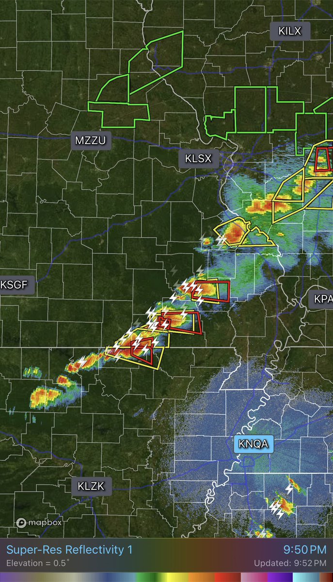
That radar hole in SE Missouri is brutal tonight. It sits between radars, so we’re basically blind to low-level rotation… tornado signatures could be there, but harder to see.
@WXmarcus This is outcome bias. The National Weather Service communicated the threat, issued watches and warnings, and protected lives. Judging it a “failure” because storms didn’t max out their ceiling misses the point.
@bobagreenwood@JohnCas48762330@ChrisMartzWX John, that’s an impressive level of confidence for someone who has zero understanding. Those equations describe the physics of the atmosphere... fluid dynamics, thermodynamics, & vorticity. Calling it an ‘easy A’ just says you never got far enough to know what it actually is.
@joeroganhq Confident language doesn't ensure objectivity in science... in fact it shows the opposite! We deal in probabilities... not absolutes like ‘virtually impossible.’ You can’t call something ‘virtually impossible’ in a system as complex as Earth’s climate!
@kapboy59@ChrisMartzWX Is this supposed to be a rebuttal to @ChrisMartzWX’s tweet? Thanks for showing your very deep knowledge on the subject of climate science. I’m tempted to bookmark this.
@ABC You know what the real problem is? Reducing complex, multi-variable human behavior into a clean, deterministic headline. Reality is far more nuanced. This is just more hyped-up doom and gloom.
@TinyTigerXO@SNHWx UNBELIEVABLE! This is exactly the problem. Not just what’s said… but how they say it! Absolute statements, talking down to people, and no room for accountability. This builds ZERO trust.
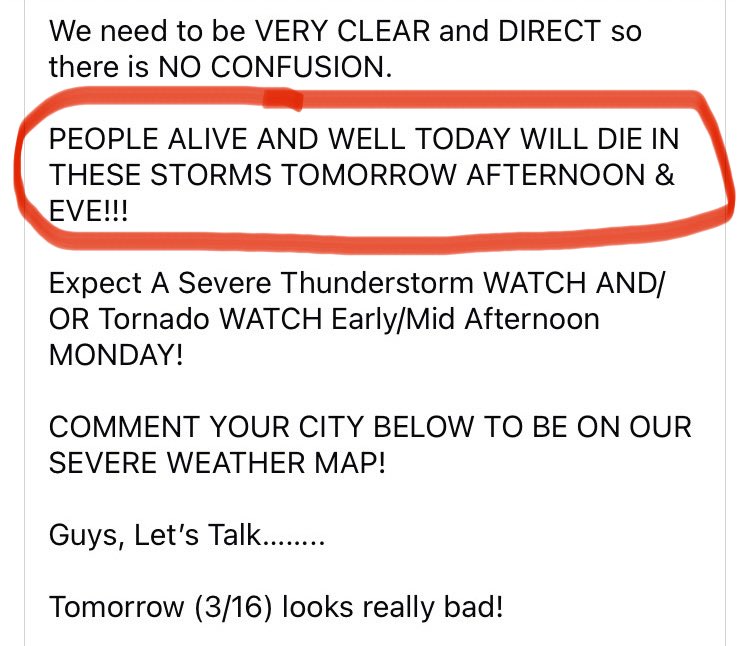
A popular weather page posted this ahead of yesterday’s severe threat. Completely reckless and irresponsible. This creates unnecessary fear, not preparedness. We as meteorologists / science-communicators are losing the battle to these toxic pages.
@DavidCorrentect Of course they did. But they continue to gaslight people who were criticizing the original post. There is ZERO accountability with these pages.
In most situations, it should take no longer than 20 seconds to reach your shelter when a warning is issued. Have a plan for those w/ limited mobility, & crate pets in your shelter BEFORE a warning is issued. These two situations are often overlooked... can't stress that enough.
Some messy/disorganized clusters already across VA could reduce degree of instability for the afternoon round which is good. Latest trends are certainly moving in the right direction of a potentially more limited severe threat. Still need to remain weather aware today.
Tomorrow’s setup for central PA doesn’t need tons of sun. Strong dynamics and shear mean storms can rapidly destabilize even with limited heating. Tornadoes are possible. The main question is storm mode… if storms are messy/disorganized early, that could temper overall threat.
Tomorrow’s setup for central PA doesn’t need tons of sun. Strong dynamics and shear mean storms can rapidly destabilize even with limited heating. Tornadoes are possible. The main question is storm mode… if storms are messy/disorganized early, that could temper overall threat.
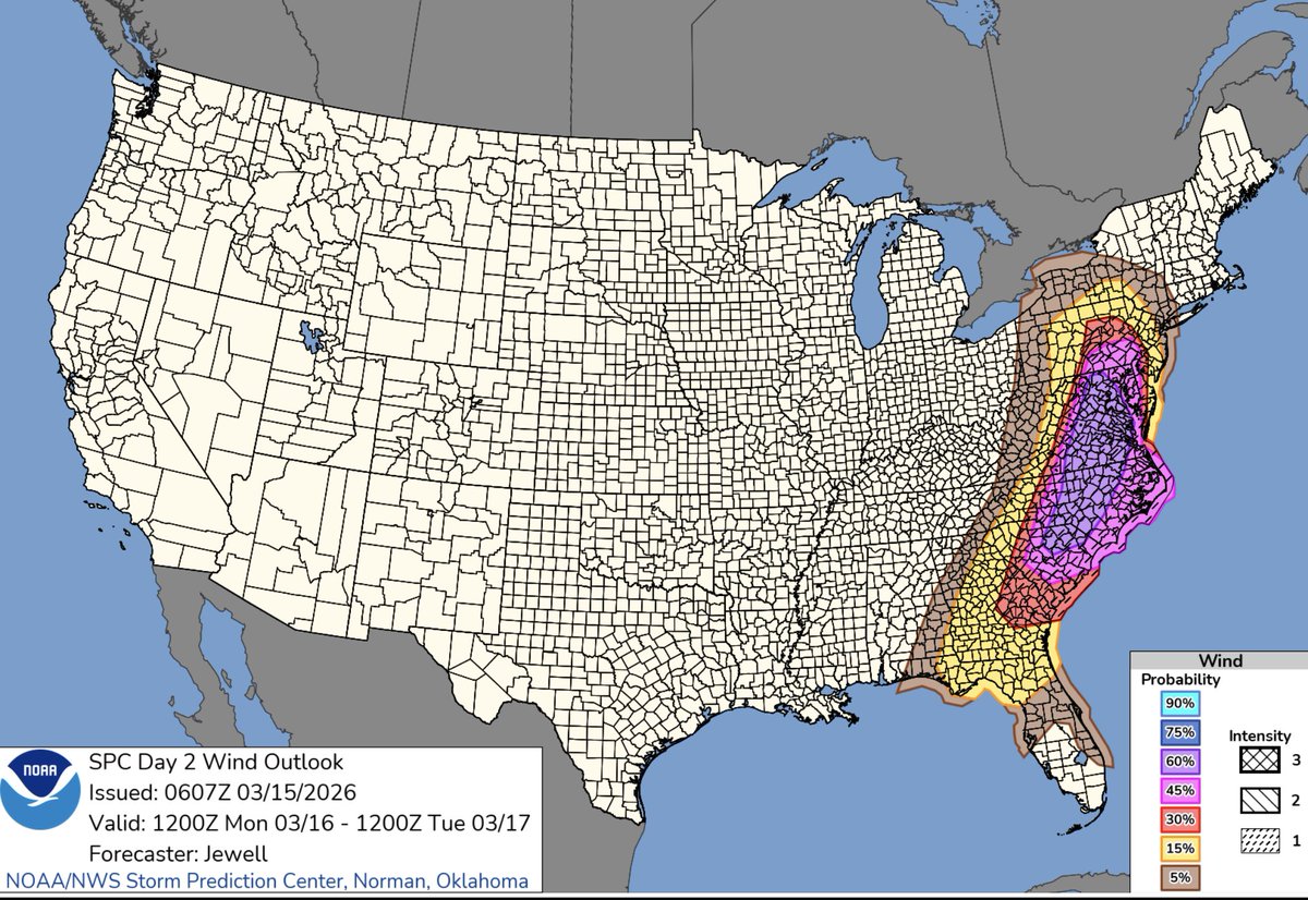
A 45% severe wind probability area in Central PA, especially at Day 2, is very rare. This speaks to the level of confidence in widespread damaging wind gusts in tomorrow’s severe thunderstorm setup. 60% probabilities extend just to our south into central MD.