A high-end westerly wind burst will soon give El Niño a significant jolt.
Warm surface water will be pushed eastward and a new downwelling Kelvin wave will probably form.
As a result, upcoming model updates may become more aggressive in their El Niño intensity forecasts.
@mountain_gaucho@DavidWLea As I said, it is a bit behind the biggest years, but also should note 2026 is ahead of other strong events like 2023. If we really get two more weeks of way below average trades, the very strongest events are on the table.
@mountain_gaucho@DavidWLea Worth an update - the anticipated WWB has materialized , with stronger winds in the forecast. 2026 is a bit behind 2015/1997 at the surface but this burst should keep it on track for significant cold tongue suppression deep into summer.
@mountain_gaucho@DavidWLea … which is well known for its strong WWB. Like the latest EPS below - anyways it will be interesting if the op GFS somehow beats all the other guidance, but seems very unlikely due to the lack of ocean info.
@webberweather@mountain_gaucho@DavidWLea 20 days ago the mean was shifted quite a ways farther west and weaker. Even 15 days ago it was too weak and slow in RMM space. I’d argue it makes a stronger event more likely to have the bigger MJO tho.
@mountain_gaucho@DavidWLea So what’s the floor for this event in your opinion? 2023? Given what I’ve seen so far, I think it’s more likely than not that 2026 joins 72 82 97 and 2015 in the high end events in the modern era, in some order. How weak would it have to be to be a bust or a false alarm?
@mountain_gaucho@DavidWLea I guess what I would ask is caution about what? Another 1997? A very strong El Niño? At this point, what’s the likelihood it doesn’t end up strong? Single digits? I don’t understand what I’m supposed to be worried about. Forecasting the strongest all time - sure. But otherwise?
Remember, even if the Atlantic hurricane season ends up being below to near normal, it only takes one storm in your community to make it a bad hurricane season for you. Prepare this year like you would any other!
@AndyHazelton I mean, there isn’t a ton of skill in summer SE rainfall years even with Nino. Composites are all over the place as well - not sure I would be worried at this point. https://t.co/VRIaMGEXsV
WHAT HAVE WE JUST WITNESSED? 🤯
Sabastian Sawe has just become the first person in history to run a sub two-hour marathon in race conditions.
Yomif Kejelcha was also under two hours for second!
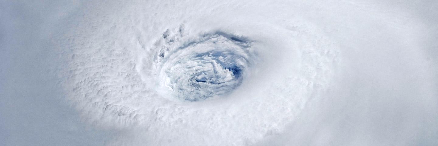
Supertyphoon #Sinlaku is putting on a show over the western Pacific this am- satellite estimates are starting to peak as high as Melissa last year! The Marianas need to be taking all precautions before this monster hits tomorrow.
@webberweather Do you have a comparison to 2014? Still one of the more interesting almost cases. That delayed but not denied event has a mild resemblance in some fields.
@WeatherProf@MattDevittWX Agreed. One of my pet peeves forever. Just can’t stomp that one out. It somehow went from quiet season to El Niño, but just flat out wasn’t in August.
@PaulRoundy1@BigJoeBastardi Strong words! - as far as the location, I’d also say the MJO is contributing as well. So speculate on how it might manifest differently with this structure