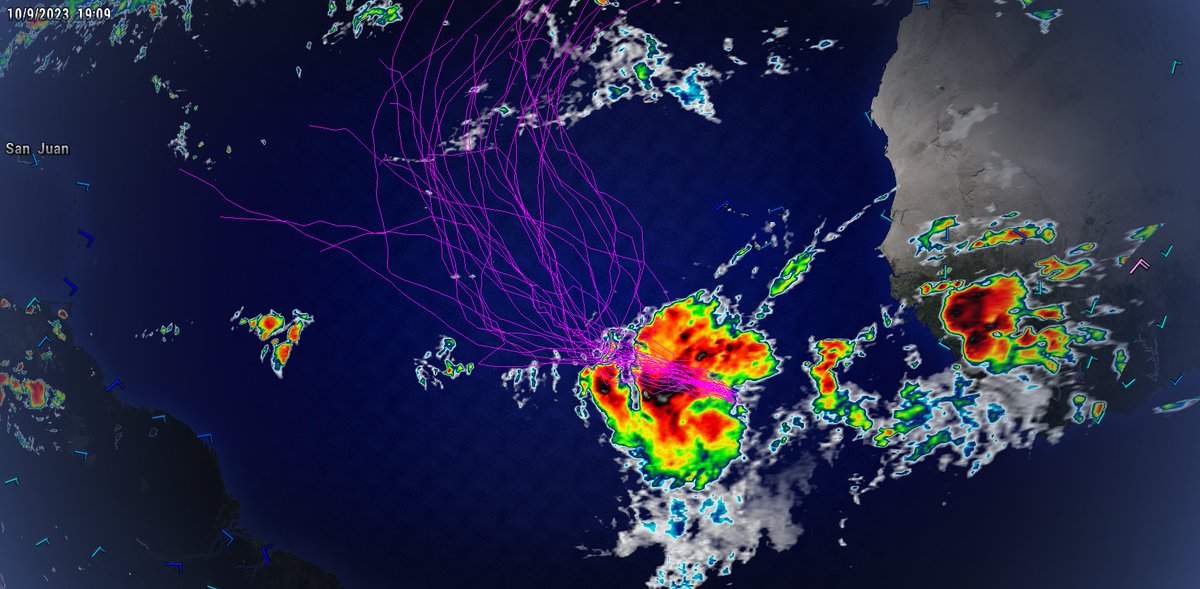
Invest #94L still remains rather disorganized this morning. There is evidence of mid-level rotation around 8.7N 35.2W, but nothing that looks well-organized atm. Models have backed off of tropical cyclone formation a bit due to an increase in shear associated with an upper-level low in the Caribbean.
NHC still has tropical cyclone formation odds at 90% for now.
Invest #94L has not become better organized today as convection has failed to maintain and tighten the broad low-level vorticity. As deep convection comes back during the DMAX period tonight, we may see the circulation become better defined. Either way, we are still likely another day or two away from getting a TC out of 94L.
It will also be worth watching where this system ends up consolidating as that will play a role in where 94L goes. Lots to watch!!
One thing to note about #94L, the overall environment is going to be rather favorable for additional development throughout the next several days. Upper-level winds are out of the east (east-to-west flow aloft) and aligned with the forward motion of the storm to the west. This along with favorable SSTs and sufficient moisture should aid in formation.
One thing to watch is if shear does increase as a result of a trough coming off the east coast of the US and dipping into the subtropics, where 94L is positioned at this time. If 94L is further north, it has a higher chance of feeling this trough and turning northward, but interacting with stronger shear, whereas if 94L is further south, it has a much better chance to continue intensifying.
We are still several days away from having a final answer on this, but this weekend should help us get some answers about the first part of the puzzle.
We turn our attention back to the Eastern Atlantic where a new tropical system is likely to form over the next week. Invest #94L is moving westward and looks like it could impact the Island chain within the next week or so. Very Unusual for this time of year.
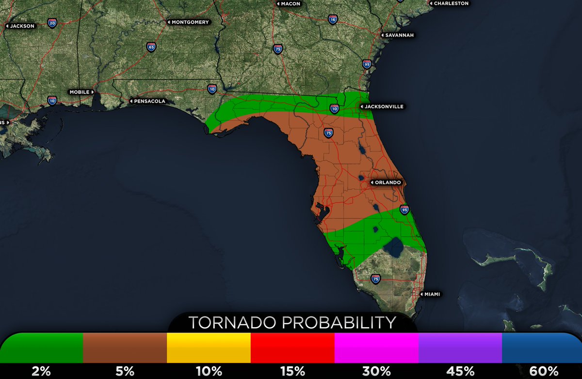
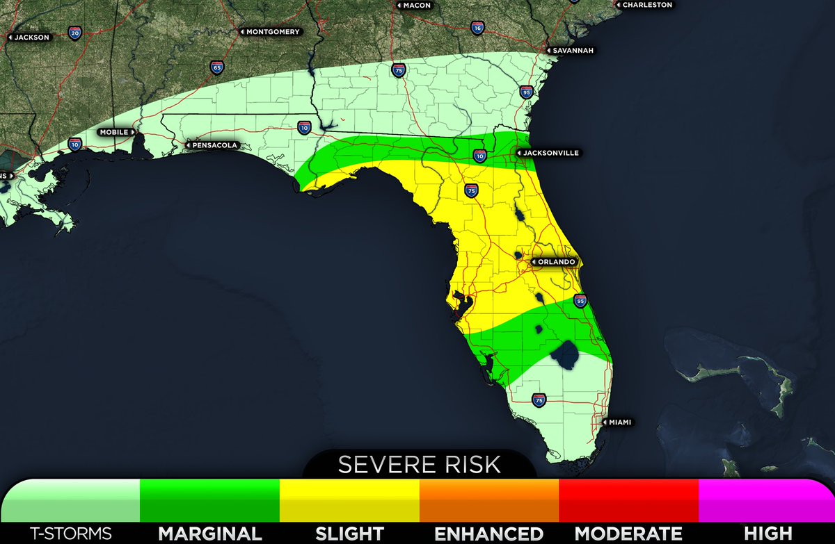
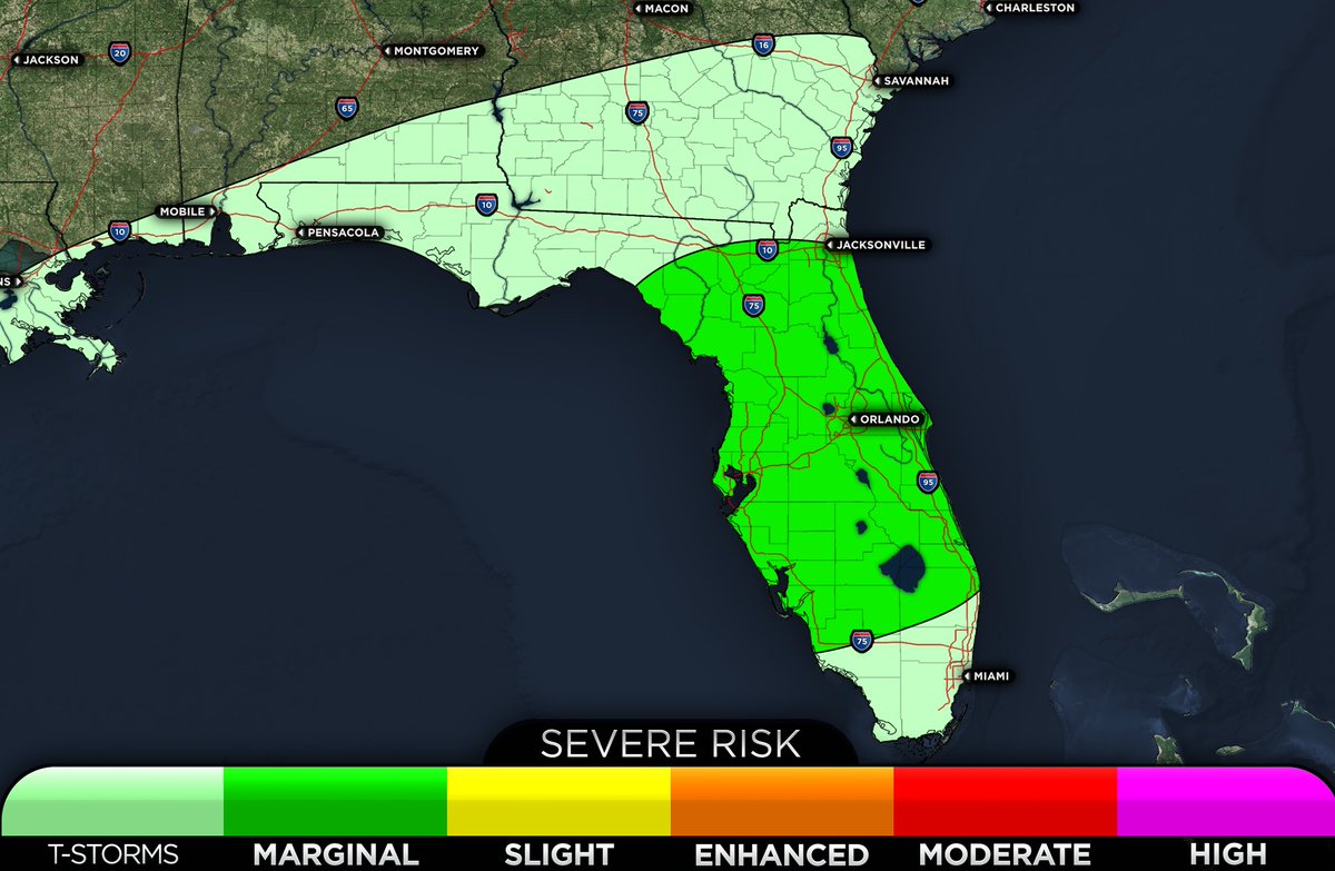
No major changes with the latest 12:30 PM ET SPC update. One minor change to the southern extent of the marginal risk (level 1/5) zone which has now been extended to near West Palm Beach. #flwx
SPC has expanded the slight risk to include more of Central and Eastern Florida as the overall ingredients appear to be more favorable over a wider area as compared to yesterday.
Timing: Severe storms could start as early as later this afternoon with storms that fire well ahead of the main surface low and associated front and continue well into the overnight hours for much of the region.
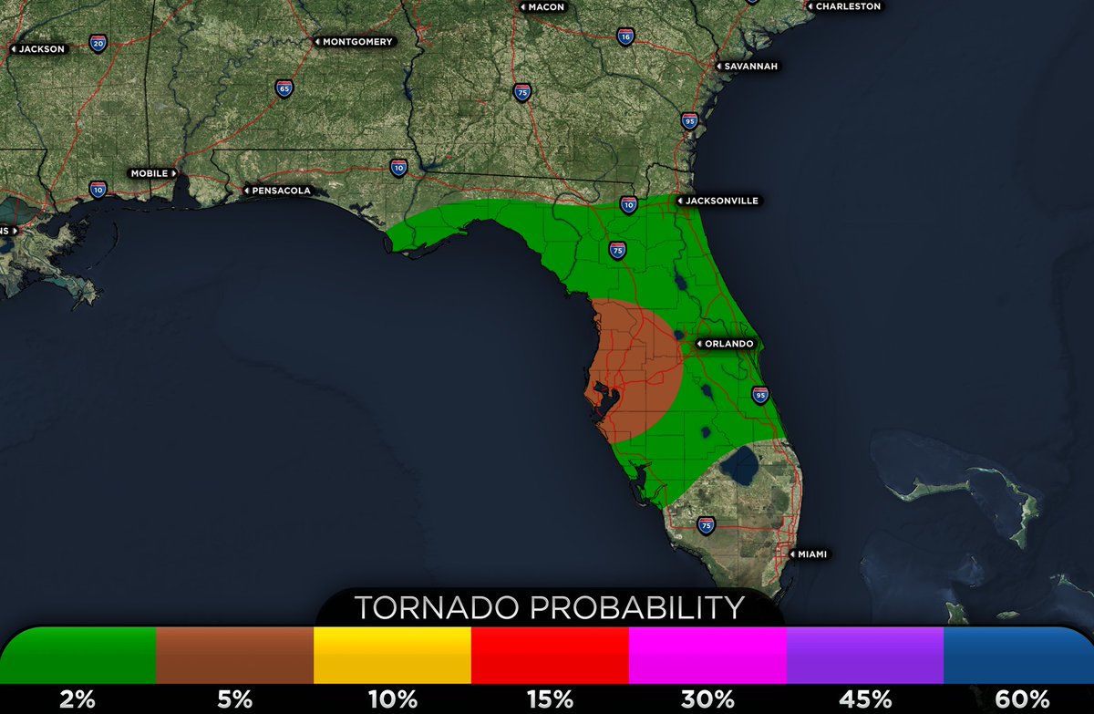
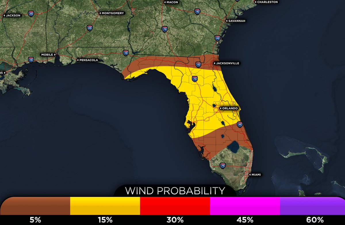
Severity: The highest threat will be from a few tornadoes and damaging winds over 60 mph. While an overall corridor of higher tornado potential may evolve where SRH and the highest CAPE overlap, there is not enough confidence to increase the risk to a level 3/5 (Enhanced risk) as of now. There is also less confidence in the overall extent of the severe weather threat the further north you go due to messy storm mode and overall lower CAPE.
Actions: Make sure to have multiple ways to receive weather warnings this afternoon into the overnight hours and have a severe weather plan in place and ready to take action if needed. #flwx
Hurricane #Lidia continues to undergo intensification and is now nearing Category 4 strength, Lidia still has 100 miles until landfall, so Lidia may become a Category 4 before landfall
Invest #93L has not really become better organized today as there is no clear low-level circulation. 93L has only another ~12-24 hours before it will merge with the cold front to the north, at which point tropical cyclone formation will no longer be possible. Either way, this low will intensify due to nontropical processes and aid in increasing the tornado threat tomorrow night for Florida. #flwx
Hurricane #Lidia has now become a major hurricane with winds of 115 mph (100 kt). Further intensification is likely until the storm makes landfall in several hours,
Hurricane #Lidia is rapidly intensifying this afternoon. VHTs are rotating around the core of Lidia resulting in rapidly lowering pressures and recently, there has been notable clearing and drying of the eye in both the Visible and IR satellite shots. Lidia is about 155 miles away from the Mexican coastline, which means that landfall will be upcoming later this evening. At this time, Lidia is going to make a run at becoming a major hurricane and could be nearing moderate to high-end category 3 intensity as it makes landfall.
The latest SPC outlook has added a slight risk (level 2/5) for portions of the Western Florida Peninsula for tomorrow night into Thursday morning. The main threats will be a few tornadoes and the threat of damaging winds over 60 mph.
It would not be surprising to see the slight risk expanded further east tomorrow morning as conditions look rather favorable across most of Central Florida.
Have multiple ways to receive weather warnings tomorrow night, as these storms could quickly spin up, resulting in a less then average lead time.
#flwx
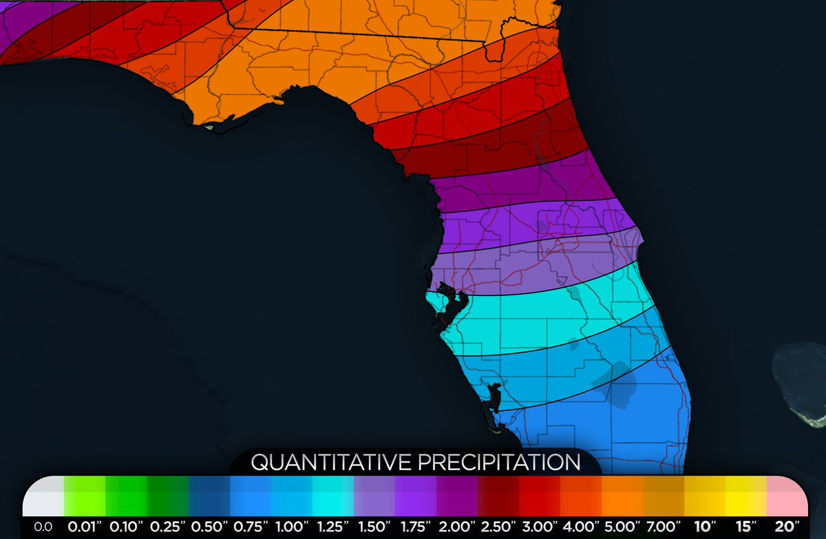
A significant heavy rain event is shaping up for portions of Northern Florida into Southern Georgia tomorrow night through Friday. Rainfall amounts here could total 4-6" with some spots receiving 7" depending on the exact placement of the heaviest rain and storms.
For Central Florida: Rainfall amounts will be on the order of 2-3" with some spots receiving 4-5" if under any training bands.
For South Florida: Rainfall amounts will be around .50-1" with some spots that could receive locally higher amounts upwards of 2-3" depending on if storms train over the same area or move slowly.
#flwx #gawx
The latest HRRR shows high PWAT values (red colors) surging northward early tomorrow morning. As the rain begins to fall, these high PWAT values will aid in high rainfall rates, which could lead to flash flooding in some locations, especially where any training bands are set up.
There is an increasing risk of severe weather associated with the increased rain threat tomorrow and Thursday. Currently, SPC has a day 2 marginal risk from Port Saint Joe to Ft. Myers with a low-end threat for a few tornadoes and damaging winds, and the same thing for Thursday with a risk for severe storms across the entire central and north Florida Peninsula.
Isolated damaging wind gusts and a few tornadoes appear to be the biggest threat with this event. #flwx
Invest #93L is still rather disorganized this morning with limited convection. As previously mentioned, 93L will merge with a cold front tomorrow and thereafter tropical cyclone formation is not expected. Either way, a big rainfall event is shaping up for the Northern Gulf coast.
Hurricane #Lidia is beginning to show signs of further intensification this morning with deep convective bursts attempting to rotate around the center. Landfall will likely be late this afternoon or early evening.
Invest #92L is becoming better organized and is expected to become a tropical cyclone within a day or two. As previously mentioned, this system will likely take a turn OTS as indicated by most of the reliable model guidance and the GFS ENS (right image).
Our system in the BoC has some spin to it this afternoon. This area of the BoC is famous for helping to aid in the formation of tropical cyclones. Still a fair bit away from TCG, but overall convection is rather robust and there is evidence of a mid-level circulation. NHC gives this system a 20% chance of becoming a tropical cyclone before it merges with a cold front to the north.
The latest high-resolution models have widespread heavy rain spreading northward into MS, AL, and GA. With more widely scattered showers and storms across Central and South Florida. There would also be the potential for a few strong to severe storms as deep layer shear is more than supportive for severe weather. Instability and lapse rates remain the biggest question. #flwx #gawx #mswx #alwx
While nice and dry now, moisture will begin to surge northward tomorrow and continue through the next several days. Where you see all the red colors, that indicates a lot of moisture in the atmosphere and higher rainfall rates. Lots of rain is incoming for the Northern Gulf Coast and Florida. #flwx