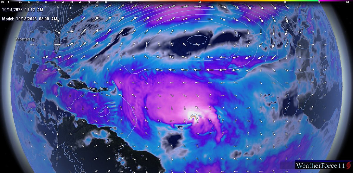
Invest #94L still remains rather disorganized this morning. There is evidence of mid-level rotation around 8.7N 35.2W, but nothing that looks well-organized atm. Models have backed off of tropical cyclone formation a bit due to an increase in shear associated with an upper-level low in the Caribbean.
NHC still has tropical cyclone formation odds at 90% for now.
Invest #94L has not become better organized today as convection has failed to maintain and tighten the broad low-level vorticity. As deep convection comes back during the DMAX period tonight, we may see the circulation become better defined. Either way, we are still likely another day or two away from getting a TC out of 94L.
It will also be worth watching where this system ends up consolidating as that will play a role in where 94L goes. Lots to watch!!
The environment surrounding #94L should remain relatively favorable for additional development throughout at least the next five days. Upper level winds in the deep tropics remain easterly, which will be a favorable position for a storm moving west across the MDR.
The one hindering factor for significant organization throughout the next day or two, would be the presence of some mid-level dry air which is shown in the GFS PWAT forecast. This could at least in theory, slow development a little bit, which would be one plausible way this storm makes it pretty far west. But overall, environmental conditions should remain largely favorable for additional development and 94L will likely become a tropical storm, or potentially a hurricane by the end of the seven day forecast period.
Within several days, the storms position is going to matter a lot in terms of impacts, and it’s remaining future. In the upper levels, a series of troughs will be digging across the United States and moving out into the north Atlantic, this will open the door for any storm in the right position to be able to turn harmlessly out to see, also an increase in vertical shear will be accompanied with these troughs, which means that if the storm is too far north, it would likely be sheared apart as it begins, it’s northward journey.
The GFS forecast for the day five period has a ridge of high-pressure located over the eastern tropical Atlantic, this would make a sun northward turn of 94L rather unlikely for now. In several days, however, the series of troughs will start to make its way across the north Atlantic, which will significantly weaken the ridge and allow an alleyway for the storm to turn towards the north. Whether this happens while the storm is already in the Caribbean, and approaching the island chain or if 94L is sufficiently far away from land that the north return would not impact the lesser Antilles remains to be seen.
A lot also depends on where it 94L will ultimately consolidate, a consolidation of the low pressure system towards the south would result in a further south system, not only initially, but at the medium and longer range, while the opposite is true for a system that consolidates further north.
Certainly a lot to watch over the next several days and interests in the lesser Antilles and greater Antilles needs to continue to monitor the progress of the system.
Invest #94L has become somewhat better defined today as there is an increase in convection and what appears to be a mid-level center around 8.6N, 30.0W. While this area of low pressure is elongated and not well-defined, the environment remains favorable for further development, and it would not be shocking to see 94L become a tropical depression or storm within the next day or two.
Really interesting that there was no power flashes that you’d typically see. Wonder if there wasn’t any lines near the path?? Anyway, really interesting to see the very low cloud bases. Nighttime plus very moist environment will do that!
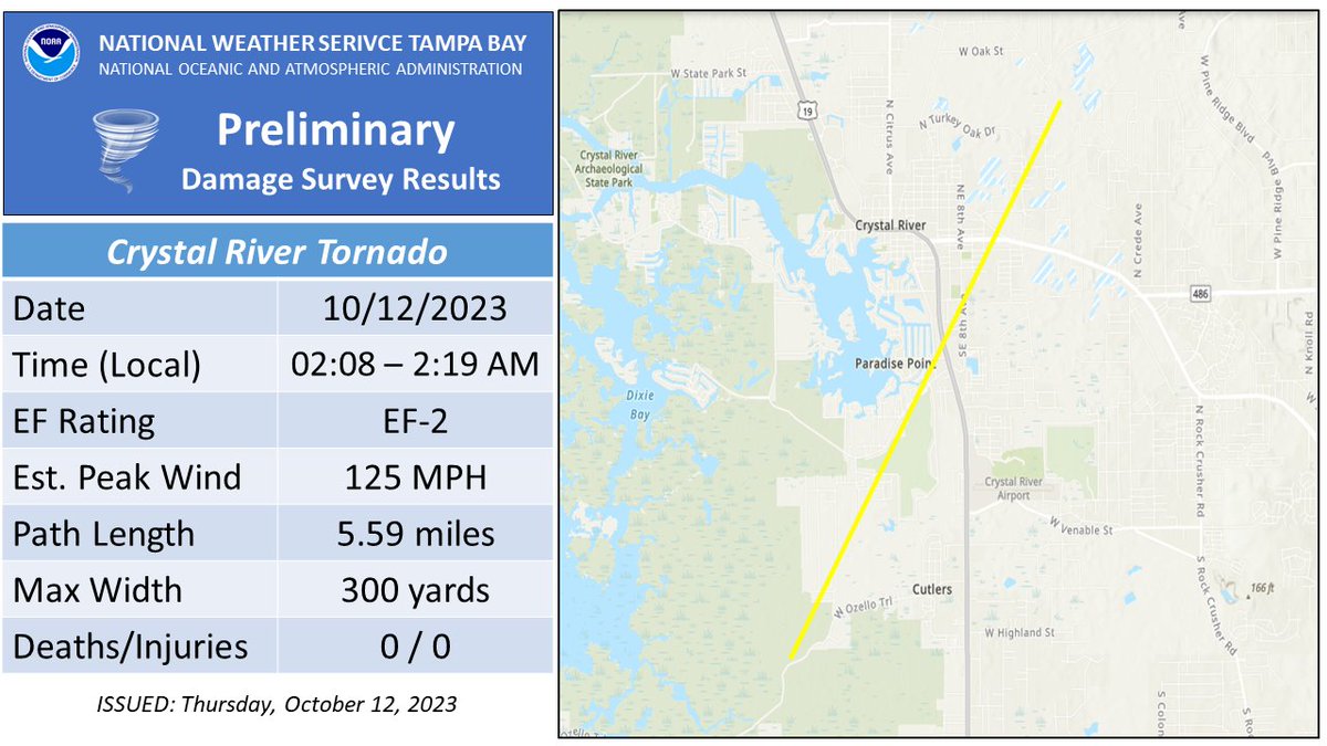
My hometown Oldsmar, FL had a Tornado Warning early AM on 10/12. I was chasing and tracking on radar. My drone footage here looks like it captured it the same area that had some significant damage. @NWSTampaBay
Mayhem at Mexico Beach: 9/
At 2 pm CDT, the Gulf waters were quickly retreating from whence they came. That’s when my three fellow most fortunate survivors ventured out of the condo for the first time and onto the back deck.
Even though Michael was continuing to move farther away from us, winds were still gusting over 100 mph.
With the surge moving back out into the GOM, MB residents’ demolished homes and their contents were floating through the canal with it…as I filmed the following scene:
One thing to note about #94L, the overall environment is going to be rather favorable for additional development throughout the next several days. Upper-level winds are out of the east (east-to-west flow aloft) and aligned with the forward motion of the storm to the west. This along with favorable SSTs and sufficient moisture should aid in formation.
One thing to watch is if shear does increase as a result of a trough coming off the east coast of the US and dipping into the subtropics, where 94L is positioned at this time. If 94L is further north, it has a higher chance of feeling this trough and turning northward, but interacting with stronger shear, whereas if 94L is further south, it has a much better chance to continue intensifying.
We are still several days away from having a final answer on this, but this weekend should help us get some answers about the first part of the puzzle.
Invest #94L is gaining some traction this evening as it moves westward. I am most intrigued about this system as it is an October MDR storm that can potentially threaten the Island chain within a week.
Although models have been jumping off and on the development train, this system now has a favorable environment to work with, and shouldn't quickly turn north. This will be something to watch during the weekend and next week.
We turn our attention back to the Eastern Atlantic where a new tropical system is likely to form over the next week. Invest #94L is moving westward and looks like it could impact the Island chain within the next week or so. Very Unusual for this time of year.
🌩️ Our local #FLwx has been active over the past 24 hours!
🌪️ 2 tornadoes have been confirmed so far (see pics below)
📈 Further review ongoing; additional confirmed tornadoes likely
📥📷 Got damage? Reply to, tag, or message us with your reports -- every detail helps!
Most of the activity was along the warm front down to the Western Coast, with one tornado reported in Flagler County. It seems like that warm front really helped to locally enhance the updrafts of the storms as most of the cells in the open warm sector failed to intensify and interact with the otherwise favorable shear.
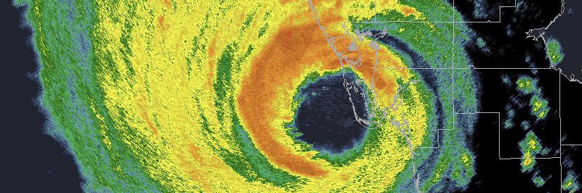
Some places saw severe weather and others didn’t (thankfully), this post from last night illustrates why the severe weather threat didn’t turn out to be worse! #flwx
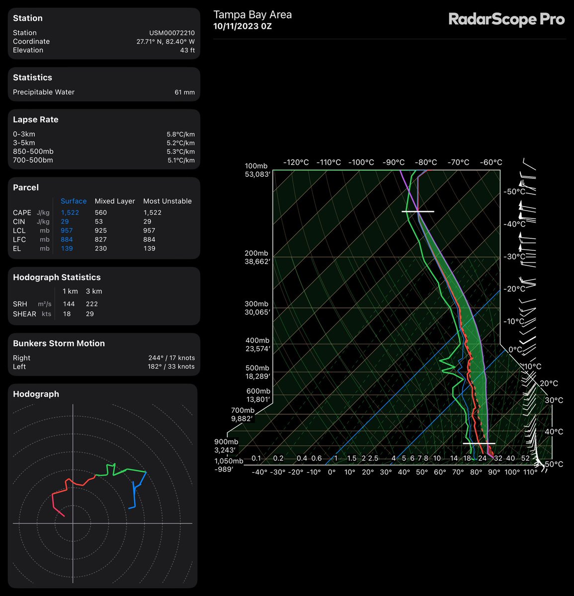
The 0Z sounding out of Tampa provides some insight into what the limiting factors are for tonight’s severe weather event:
For one, the lapse rate (or the change of temperature with height) isn’t all that impressive. This is due to a rather saturated atmosphere from ground all the way up to the top of the atmosphere. This means that storms tonight will have a somewhat difficult time getting their act together and sustaining themselves.
In the same token, instability isn’t all that high either with MLCAPE (mixed layer instability) not even in the 600s (yet), this will change some tonight as instability will rise especially along the coast. Further island, instability will be slower to rise, but should be near 700-1000 J/KG by early morning which should be enough to support a conditional tornado threat inland.
On the other hand, strong low level shear will aid in any storm that can overcome these obstacles and enable a brief tornado threat to materialize especially near the Big bend of Florida down through Tampa Bay with a more conditional risk inland. #flwx
Several areas of rotation/possible waterspouts offshore will be moving in the general direction of Tampa over the next hour or so. Got to watch to see if these hold together #flwx