Undergraduate student at University of Reading studying Meteorology and Climate, has been tracking Atlantic Extratropical Cyclones since OESMC founded in 2023.
***Storm Adam***
#DanaAdam is now located over Northern Italy and its upper level structure is starting to dissipate. Moderate to high amount of rainfall of 100~150mm and local mountain gusts between 60 and 70kt is still expected in western Balkans and parts of northwestern Italy, with asscociated orange and yellow warnings for wind and rain active. It is advise that residents in the affected region to follow instructions from national or regional weather services.
***Storm Austen***
#StormAusten has now obtained a full circle of circulation and is on its way across the Atlantic. Model tracks has shifted slightly more to the south, and as a result northern France will likely see the same level of wind gusts as souther England, with widespread coastal gusts of 60-70kt and local maxima above 75kt. The Met Office has issued an amber wind warning for Cornwall, while Met Éireann issued a full orange warning for southern Ireland, and AEMET issued an orange coastalevent warning for the entire northern Spanish coast. It is advised that residents of northwestern France, Benelux, Germany, Denmark and the 3 countries mentioned above to be up-to-date with any updates on forecasts and warnings.
***
Over or near Scottish Highlands: An intense low of at least Category 3 strength will enter the region with a band of strong winds to its south. Models has been better agreed about the track, but still uncertain about the maximum expected gust speed, though the most likely scenario will be 65~70kt gusts widely on coastlines and up to 80kt over mountain peaks. The system has a 20% chance of being named by the Western Group in the next 0-2 days and a 40% chance in the next 0-5 days.
***Storm Adam***
#DanaAdam has moved away from Spain but it continues to produce high amount of rainfall in the Ligurian Sea region. Some Areas of southern France and northern Italy will see another 200mm of precipitation through the next 24 hours. A red warning for rain and flood has been issued for Corsica and equivalent in 4 regions of Italy. It is strongly advised that residents in or near the affected region to follow instruction from national or local weather services and be up-to-date with any changes.
***Storm Austen***
#StormAusten has been named by the Met Office earlier today, and its circulation is already forming to the Northeast of Tropical Disturbance 93L. Models are now in agreement that the strongest wind will be in southwestern England, southern Ireland and southern Wales, where gusts can reach 60-70kt widely along the coast and local extremes of up to 80kt. Amber warning(s) for wind will likely be issued tomorrow as conditions become clearer.
***
Near northern Scotland: Models are better agreed today that a low developing later this week will pass very close by or make landfall in Scotland, with peak intensity of Category 3~4. The maximum gust expected still varies, but possibility that a scenario which maximum gusts of 70~80kt occurin Outer Hebrides is higher than that of the better scenario, which gusts do not exceed 65kt. The system has a 30% chance of being named by the Western Group in the next 2-5 days.
***Storm Adam***
#DanaAdam has entered the Mediterranean Sea and hence the region of highest precipitation has now shifted eastward. Heaviest rain in Eastern Spain has passed, while Southern France and Western Italy will be facing similar impact next, with maximum daily rainfall totals of around 200mm and intermittent thunderstorms. Various orange and red-equivalent warnings will be active through tonight into tomorrow in this region, so it is strongly advised that residents in this region to follow further instructions from national or regional weather services and be up-to-date about the information.
***
On southern Ireland and British Channel coasts: A low will develop starting from tomorrow and bring strong wind to this region from Thursday night to Friday Morning. Despite that the center of the low will most likely pass through UK, its strongest wind in the southern semicircle could move through either Wales and southern England or northern France, where widespread gusts of 60kt and local maxima of 80kt are expected. The Met Office has already issued a yellow warning for wind, claiming the impact is at mid-to high level with low possibility, thus it may be upgraded into an amber warning when possibility rises. The system has a 50% chance of being named by the Western or the Southwestern Group in the next 0-2 days and an 80% chance in the next 0-5 days.
***
Near the north coast of Scotland: Models are still disagreed about a low that may pass near Northern Scotland during next weekend. In worst case scenarios, suggested by GEM, gusts may exceed 80kts in Scottish Highlands, while in the runs of some other models the gust stay well below 65kt. The system has a 10% chance of being named by the Western Group in the next 2-5 days.
@F1news_foryou You're right, my points was a bit contradictory here... I mean, if it get shifted even further south it may end up being named by Meteo France, but in which case it will not make landfall in Great Britain.
***Storm Adam***
#DanaAdam has gradually moved eastward throughout the last 24 hours, and its main region of precipitation is now located in the Valencian Community. Local daily rainfall may exceed 300mm, and 12-hour accumulation reaching 200mm. Several red, orange and yellow warnings active in this region, and Italian Servizo Meteorologico also expect extreme rainfall in the Northwestern parts of the country later today. It is strongly advised that residents in these regions to follow further instructions from national weather services.
***
Over Ireland, England, Wales, Normandy and Benelux: An area of low pressure will gain hurricane-force winds while crossing the Atlantic and make landfall on Great Britain on Friday. Its forecasted trajectory has been shifted south by the models in latest runs, so chances of gusts between 60kt and 90kt cannot be excluded for all coasts of Southern Ireland, Southern UK (especially the Bristol Channel), and either edges of the British Channel. The system has a 10% chance of being named by the Western or Southwestern Group in the next 0-2 days and a 50% chance in the next 0-5 days.
***
Near the north coast of Scotland: A seperate low will develop slightly later than the system above, and will strengthen into a Category 3 or 4 Extratropical Cyclone near Scotland according to all models but GFS. Widespread gusts of 60-75kt will be possible on the coastal regions of Scotland and Northern parts of Ireland, as well as over mountain ranges of Scotland. The system has a 10% chance of being named by the Western Group in the next 2-5 days.
@WXWatcher07 Congrats, I appreciate all your devotion into providing accurate forecasts (and I hope I can make some achievements on this one day as well).
***Storm Adam***
Storm Adam has been identified as a DANA and hence, its trajectory shown in the image roughly represents center of highest precipitation. In the next 3 days, it will cause severe convective weather along the Southeastern coast of Spain, with maximum daily accumulated rainfall reaching 300~400mm at some locations, and hourly precipitation reaching 60~80mm. AEMET will be issuing multiple orange or red warnings through this period, and it is strongly advised that residents of Spain to follow their instructions up-to-date.
***
Over Ireland and Nortern-Central Great Britain: An area of low will move through the Atlantic next weekend and bring intense weather conditions to Western Europe. Earlier model forecasts about the control of a ridge with unusually high pressure over Europe has failed due to the unexpected strengthening of the Icelandic Low following 2 lower-level Category 2 extratropical cyclogenesis which will push the ridge further south, meanwhile allowing the jet stream to aim toward the Irish coast. Environment will be favourable for the system's explosive cyclogenesis, though maximum gusts on the coast can vary from 70kt to 100kt depending on the system's trajectory. The system has a 20% chance of being named by the Western Group in the next 2-5 days.
***Storm Adam***
Storm Adam was named unexpectedly early at 12z today by the AEMET and has been forecasted to drop 200~300mm of rain at some locations along the Mediterranean Coasts, including the Balearic Islands, from Sunday to Monday. Residents in the regions mentioned above should follow further instructions from AEMET. As for this point, AEMET has not yet clarify whether the name is assigned to the surface low forming in the Mediterranean during the weekend or the upper-level DANA. Hence, OESMC cannot provide a track forecast of this system in today's post, but will hopefully resume tomorrow.
***
In the Western Mediterranean and its surrounding lands: A weak low pressure system is forecasted to develop from a stationary front that was origionally the cold front of Ex-Isaias in this region next Monday. Following its interaction with a DANA located to its northwest which provides inflow of clod air, heavy rainfall of 200mm higher may fall within a 24h period on parts of the Balearic Islands. The system has a 10% chance of being named by the Southwestern Group in the next 2-5 days.
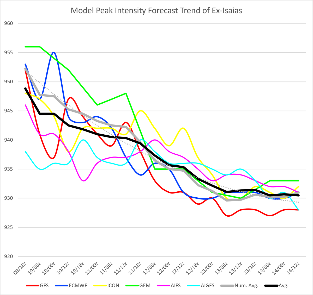
Earlier today, Ex-#Isaias has rapidly deepened south of Iceland and become the deepest North Atlantic Extratropical Cyclone since at least 2022 (Fig. 1). Models suggested a peak surface pressure between 927 and 933hpa, but a more precise intensity can be estimated using a method that combines model data with observation data, in this case from a buoy close to the center. After discussion with NSWC, another unoffical agency monitoring non-tropical weather systems, the methodology of OESMC in this specific case has been decided to be as shown in the 3 paragraphs below.
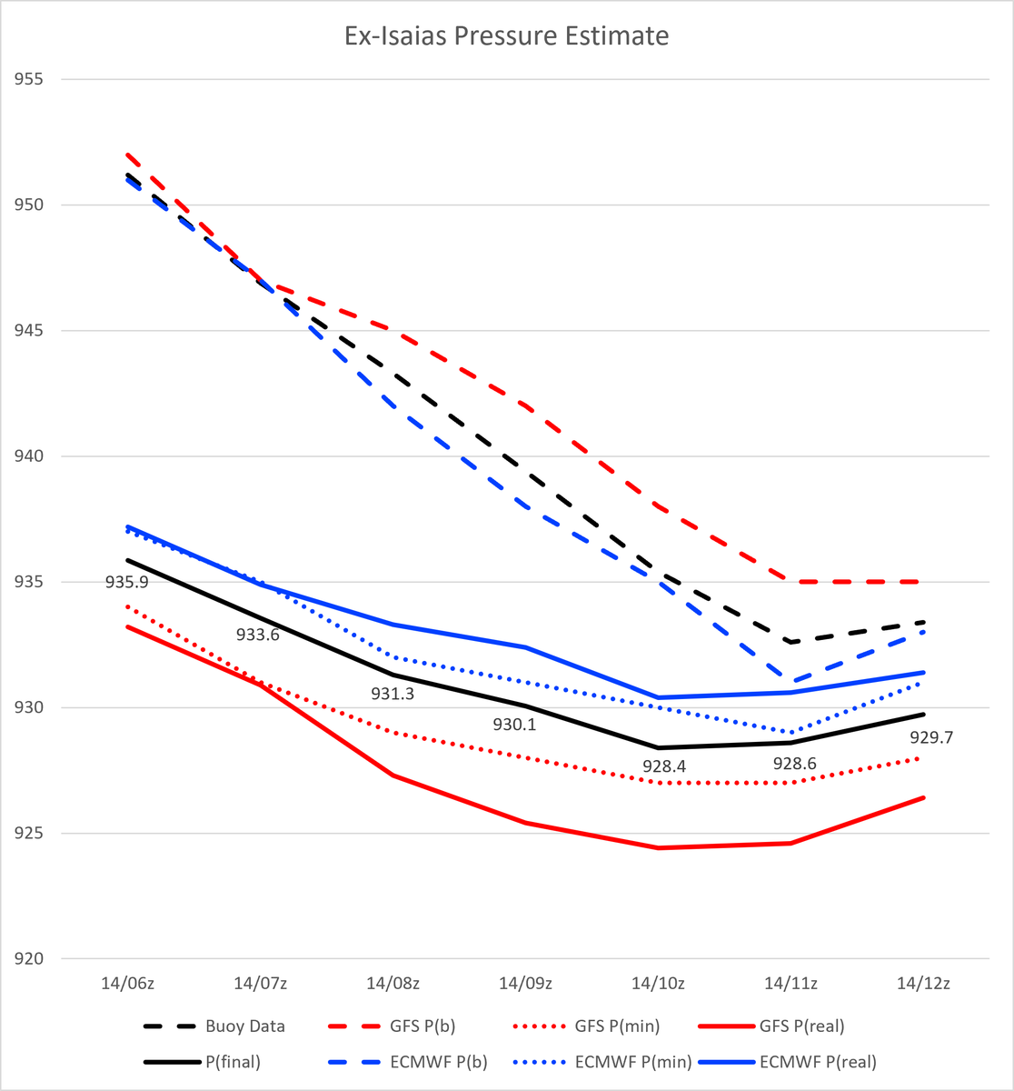
In Fig. 2, P(b) represent the estimated pressure at the buoy according to the model, and P(min) represent the estimated minimum pressure of the cyclone by the model. The difference of the 2 pressure values can be directly subtracted from the measured pressure of the buoy at the same time to get an estimation of P(real), the real minimum pressure of the model, though such pressure subtraction should be shared by weights from different models for better accuracy.
Usually the ratio used by OESMC between GFS, ECMWF and ICON, the 3 most trusted numerical models are 1:1:1. However, the poor performance of ICON in analyzing the structure of Ex-Isaias and a clearly more accurate structure analysis from ECMWF (compared with wind fields demonstrated by scatterometers) has prompted a ratio of 1:2:0. The final pressure estimate is noted as P(final).
This method is based on the observation that pressure gradient is better forecasted by models rather than the minimum pressure itself in most cases. The estimated peak surface pressure of Ex-Isaias turned out to be 928.4hpa, and all estimates are subjected to an error of ±1hpa (not accounting any additional error from the buoy itself).
An additional image (Fig. 3) is included to demonstrate how dramatic models decreased its minimum pressure run by run starting from 114h before its peak.
***
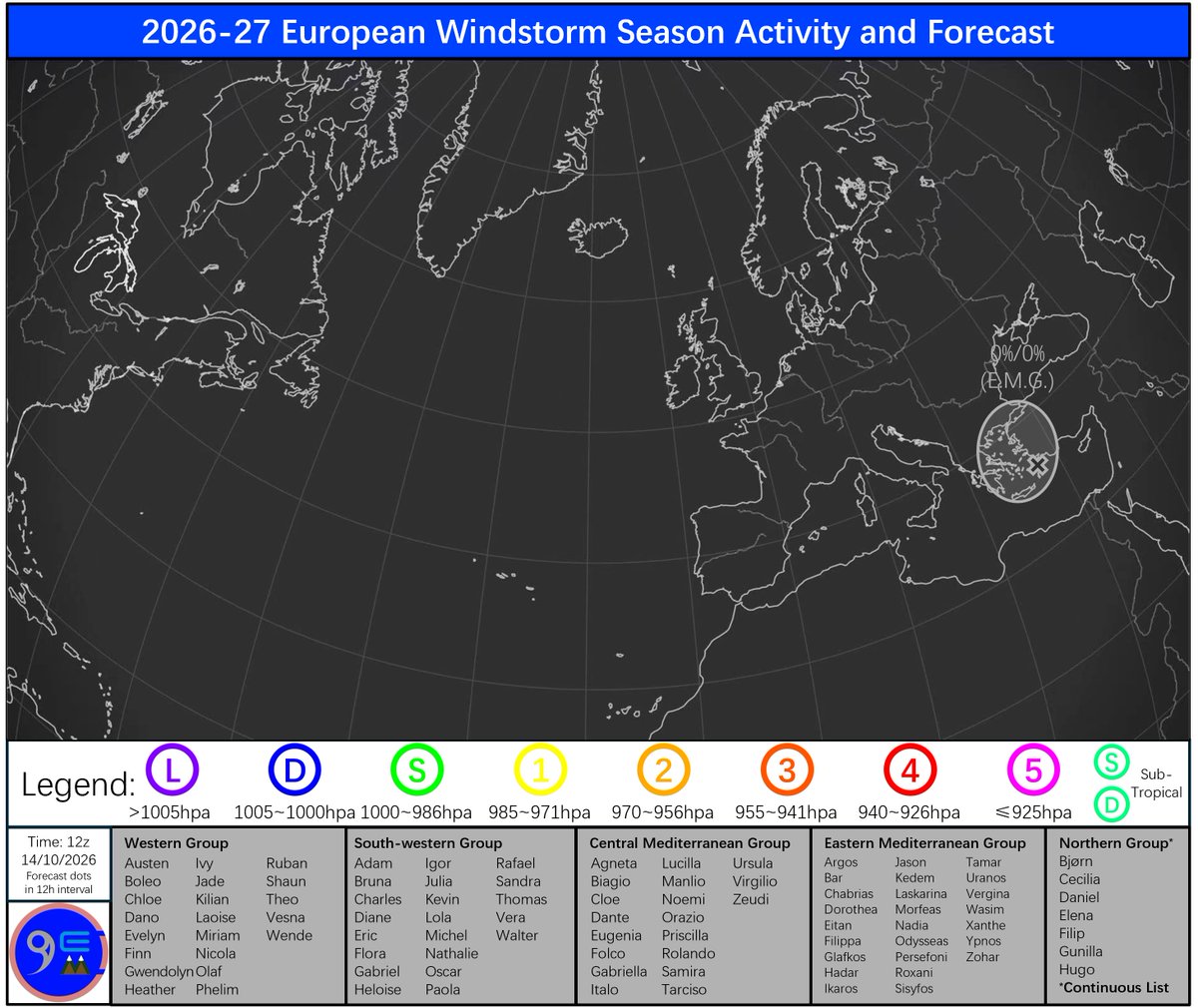
In the Aegean Sea and its islands: An extratropical depression is causing significant impact over the region, with widespread thunderstorms, heavy rain of 100-150mm in the next 24 hours, strong winds potentially reaching 80kts over mountain peaks per ICON forecasts. Red warnings for wind, rain and thunderstorms are all in place today for parts of Greece, but the HNMS has decided not to push foward on assigning it a name. Hence, naming of the system is no longer expected.
(0% chance information will be included if the chances for that system being named in the previous post is medium or higher.)
@F1news_foryou I agree, but HNMS isn't responding, and I couldn't go through the Central Group upgrade process either 'cause it didn't impact Germany and doesn't have a FUB name :(
***
In the Aegean Sea and its islands: Models have mostly agreed that a cut-off low currently located at the west coast of Greece will cause 200mm or higher rainfall on the island of Euboea through tonight into tomorrow. The HNMS has already issued red rain and thunderstorm warnings for the island, though neither their media nor the FUB has shown any signs of naming the system before tomorrow noontime. The system has a 40% chance of being named by the Eastern Mediterranean Group in the next 0-5 days.
***
In the Aegean Sea and its islands: Increasing number of models are showing a scenario that a cut-off low dropping over 200mm of rainfall within a day on the island of Euboea. Red warnings for rain and thunderstorm will hence be likely to be issued some time later for the island, which may further lead to the system receiving a name. The system has a 40% chance of being named by the Eastern Mediterranean Group in the next 0-5 days.
***
Near the south coast of Iceland: The extratropical remanents of Hurricane Isaias has re-developed after entering the open Atlantic and will rapidly intensify into a Category 4 Extratropical Cyclone near Iceland. As models are suggesting increasing peak intensity, the distance between Scotland and its peak location also increases. Recent responds from the Met Office vaguely indicated that the gusts of around 65kt in the Hebrides should be localised enough to not cause significant impact. The system has a 10% of being named by the Western Group or be granted windstorm status with the name 'Ex-Isaias' in the next 0-5 days.
***
Over Aegean Sea and its islands: An upper-level trough will prompt the development of a surface low near Greece on Tuesday, which will move into the Aegean Sea on Wednesday. Some models has suggested the possibility of 200mm precipitation on the island of Evoia, while other models like the GEM has the rainfall not exceeding 50mm over the same period. The system has a 10% chance of being named by the Eastern Mediterranean Group in the next 0-2 days and a 20% chance in the next 0-5 days.
***
Near the south coast of Iceland: A low associated with the extratropical remanents of Hurricane Isaias will combine with another low and pass near or make landfall in Iceland, with peak intensity most likely reaching Category 4. Models has retained their forecasts that the cold front will cause coastal gusts of 60-65kt in Outer Hebrides on Wednesday, which should be below the threshold of naming. The system has a 10% chance of being named by the Western Group in the next 0-2 days and a 20% chance in the next 0-5 days.
***Storm Felicia***
Storm Felicia has left the Baltic Region and on its journey toward Siberia, which means that its impact in EUMETNET member states will end soon. Gale-force gusts around the souther Baltic Sea will last until midnight, and hence there are still some yellow warnings in parts of Sweden, Finland, all of the Baltic States and Poland. This is the last advisory on this system from OESMC. It is advised that residents in this region to follow further instructions from local agencies.
***
Between Scotland and Iceland: A low associated with the extratropical remanents of Hurricane Isaias will undergo explosive cyclogenesis from next Tuesday, and will eventually reach its peak of Category 3 or even Category 4 strength near the south coast of Iceland. Albeit not making landfall directly, its cold front will cause widespread coastal gusts of 60-65kt in northwestern part of Scotland. Met Office has started to monitor the evolution of this system from yesterday. The system has a 20% chance of being named by the Western Group or be granted windstorm status with the name 'Ex-Isaias' in the next 2-5 days.
***Storm Felicia***
Storm Felicia has reached Category 1 status expected earlier today, and will continue to impact the Baltic Region. In addition to warnings yesterday, Poland issued a red warning for wind for its northern coast (though their threshold is lower). Gusts from 55kt to 65kt will wistand in Eastern Sweden, Poland and the Baltic States this afternoon and even though the warm front has moved away from Sweden, there are still risks of flooding from snowmelt in the following days. It is advised that residents in this region to follow further instructions from local agencies.
***
In northwestern Scotland: The future remanents of Hurricane Isaias and another low previously forecasted to approach Scotland and the Faroe Islands seperately has appeared to merge into a combined low in current moel runs. The system will more likely to stay offshore, but it may still deliver gusts of 70-75kt with its cold front to some locations in a region stretching from the Outer Hebridies to Shetland, depending on the exact track. The system has a 20% chance of being named by the Western Group in the next 2-5 days.
***
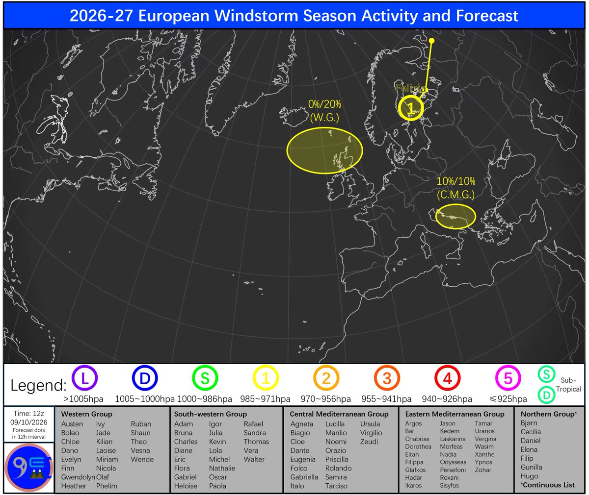
In western Balkans: A Genoa Low will develop across the weekend into Monday and cause some intense precipitation in Western Balkans, though none of the models are now showing a scenario with over 150mm in a 24h period. Hence, it is increasingly unlikely that the system does not receive a name. The system has a 10% chance of being named by the Central Mediterranean Group in the next 0-5 days.