Interested in weather forecasts? Storm chaser trying to find the next tornado?
Try your hand at weather forecasting using computer model guidance, and raw forecasts that meteorologists use. Including some of our own proprietary maps to help guide you like our APRWX Severe and Tornado indices.
Now you can check out F5Weather for 2 weeks for free!
Use coupon code 2WEEKS at check-out, and give it a try.
If you like what you see, keep the subscription active and you'll be grandfathered in to Professional level service at $14.95/mo. Not happy with it? Just click the cancel button after you've enjoyed those 2 free weeks during the heart of tornado season.
Get an account to get started:
https://t.co/6mYDxC4kPn
This Week in Weather — May 19 to May 24
Unusually cold conditions are still gripping the central part of the country this week. The jet will generally come out of the southwest and head toward the Great Lakes and then to Quebec. This sets up a warmer dome over parts of the Southeast, but still much of the area will be near normal or even cooler than normal by the end of the period. The cooler temperatures across the central into the Great Lakes is largely due to storms and heavy rain keeping the temps down.
Just east of those storms, the narrow band of record heat in the east will ease by Thursday & Friday.
In the north, freeze warnings and frost advisories are covering much of the Dakotas, Minnesota Wyoming and into parts of Nebraska.
Tuesday some thunder and scattered severe looks likely from Missouri to southeastern Ontario. The SPC has a slight risk area for severe weather from Lakes Ontario & Erie down the Ohio Valley towards the Paducah, KY vicinity. Some gusty straight-line winds are the primary threat in this area today. Another area of storms look possible in south Texas where another slight risk for severe weather exists today.
In northwestern Ontario, some snow and even ice look possible today, thanks to the unusually cold air settled across the area.
This cold air will likely only be around this week, as guidance suggests much above normal temperatures starting next week for most of the nation.
In the west, pleasant weather is expected this week, with sunshine and dry conditions for most, and slightly above normal temperatures in the Pacific Northwest.
See the latest at https://t.co/CB1e7ybMM2
Interested in weather forecasts? Storm chaser trying to find the next tornado?
Try your hand at weather forecasting using computer model guidance, and raw forecasts that meteorologists use. Including some of our own proprietary maps to help guide you like our APRWX Severe and Tornado indices.
Now you can check out F5Weather for 2 weeks for free!
Use coupon code 2WEEKS at check-out, and give it a try.
If you like what you see, keep the subscription active and you'll be grandfathered in to Professional level service at $14.95/mo. Not happy with it? Just click the cancel button after you've enjoyed those 2 free weeks during the heart of tornado season.
Get an account to get started:
https://t.co/6mYDxC4kPn
This week the jet stream will generally be zonal across the northern tier of the country, although there will be quite a few waves along it.
This position will help to build a warm bubble across much of the west and central part of the country, with above normal temperatures from western Mexico into the Northern Plains.
Cooler than normal temperatures will wrap around this wedge, in the Pacific Northwest, across Canada, and then down much into much of the Eastern part of the country to Georgia.
It doesn't look like any real big organized severe weather episodes are likely, however Saturday would be the best chance if that did occur. Storms look possible Saturday from Michigan southwest to Kansas and Missouri. Perhaps even into western Oklahoma, as the SPC currently is outlining that area for the potential of severe storms.
Some heavier rains look possible in parts of New England and Florida this week.
Areas like Tennessee, The Front Range and of course the Southwest look to have abundant sunshine.
See the latest at https://t.co/CB1e7ybMM2
This Week in Weather — May 5 to May 10
This week will again be generally cooler than normal over much of the lower 48 states. Warm conditions will exist in the western Rockies, over Florida and coastal New England.
A late season snowfall is expected over the Colorado Rockies. The biggest totals (6"+) will be in the higher elevations, but even Denver could see 3-6" Tuesday into Wednesday.
The storm tracks will generally stay across the southern Plains toward the Mid-Atlantic, with unusually dry conditions expected in the west. It will be sunny, warm and dry over much of Washington & Oregon south to Arizona into Mexico. This will hurt an already dry situation over most of that area, and increase the fire danger. The longer range forecasts give the Pacific Northwest pretty dry conditions over the next 3-4 weeks.
Rounds of thunderstorms with some severe storms, are expected across the south and east. Today, Tuesday, some isolated strong storms look possible south of the lower Great Lakes into northern New England.
Another more organized area of severe weather looks likely over Arkansas on Tuesday. This area will drift to the south and east for Wednesday into the deep south. The area will transition eastward posing a threat for severe storms on Thursday in the Carolinas.
Looking way out to next weekend, some severe weather looks possible Saturday over eastern Kansas and across Missouri and maybe into Illinois.
See the latest at https://t.co/CB1e7ybMM2
Weather map/data nerd? Storm chaser? Emergency manager? Meteorologist?
New & existing F5Weather customers can add on 3 or even 5 years of subscription time, and save hundreds of dollars!
It's a non-recurring one time fee, so there are no surprising charges afterwards.
Eliminate those monthly fees and save money in the process.
Enter coupon code BIGDISC at check-out, while it lasts!
https://t.co/SXGJ9XEszI
This Week in Weather — April 14 to April 19
We're starting the week out with severe storms, flooding, hail and tornadoes across the north-central part of the country. On Monday, there were 15 tornado reports, 21 damaging wind reports, and 161 hail reports across parts of northern Iowa, southern Minnesota into Wisconsin, as well as eastern Kansas. This will continue to extend to the east across the Great Lakes and Northeast over the next few days.
Severe storms this week look possible, if not likely from Texas to Michigan and east to New England. Very heavy rains are expected within this area in the northern tier from eastern Iowa to New England, and north into southern Ontario and Quebec.
Farther north, winter still has a grasp over parts of Canada where heavy snow and freezing rain look possible this week. Some heavy mountain snows are also expected in the Pacific Northwest, with heavy coastal rains in western Washington and Oregon.
The Jet stream will largely bisect the nation from the Southwest toward the Great Lakes. East of here generally warm and stormy conditions are expected, especially closer to the jet stream. Farther from the jet, in the southeast, unusually dry conditions are expected. It will be sunny and dry over Florida. This will only aggrevate an already extreme to exceptional drought across the state.
In the west, generally cooler than normal conditions are expected, with sunny skies expected in the southwest, and into western Kansas.
See the latest at https://t.co/CB1e7ybMM2
Weather map/data nerd? Storm chaser? Emergency manager? Meteorologist?
New & existing F5Weather customers can add on 3 or even 5 years of subscription time, and save hundreds of dollars!
It's a non-recurring one time fee, so there are no surprising charges afterwards.
Eliminate those monthly fees and save money in the process.
Enter coupon code BIGDISC at check-out, while it lasts!
https://t.co/SXGJ9XEszI
Humans achieved an incredible milestone as the 4 member crew of Artemis II went further into space than any human before them. They passed around the dark side of the moon and have now begun their return trajectory back home.
In other news, the CPC is forecasting an expansion of the drought in the west and into the plains this spring.
A multi-day severe weather outbreak may be brewing starting next weekend and perhaps into early next week across the central states.
Follow us for more weather news like this, or join our newsletter mailing list.
https://t.co/b6o616xJnG
We have released our 'F5Weather Forecasts' app in the Google Play Store and Apple's App Store! It is a simple, free app focusing on our proprietary forecast. It's in it's infancy stage as we have big plans for improving the forecast accuracy. We also will soon have features like travel forecasts, and hourly forecast time steps out to at least 10 days. Try it. If you like it, please give us a good review!
https://t.co/6yYZC2o09H
This Week in Weather — April 5 to April 12
This week a split jet will keep the really big storms at bay for a while. One leg of the jet will reside from the north-central part of the country to the northeast, pretty much right along the Canadian border. This will bottle up most of the cold air in Canada, with some of it spilling out over the Northern Plains, Great Lakes and Northeast this week. Any big snows will be kept to our north, as it should be for this time of year. The southern jet basically follows the Mexico border.
This will keep the lower 48 states overall pretty mundane. It will be warm in the west and southwest, and cool in the northeast as a rule.
Next weekend there could be some heavy rain and severe storms over parts of the plains. Warm air will surge northward in that time frame as well. This will set the stage for perhaps a few days of severe weather in the central part of the country, extending into early next week.
It will be dry and sunny over the deep south -- think Huntsville/Atlanta. The next couple days will remain unsettled over Florida as a frontal boundary fires off showers and thunderstorms across the peninsula.
See the latest at https://t.co/CB1e7ybMM2
This Week in Weather — March 10 to March 15
This week will be another active one for most of the country. The jet is laying across the northern tier, bottling up the colder air primarily in Canada, with some spilling over into the northern states.
Here is where a strong storm is expected to track from west to east this coming weekend. To the south, in the warm sector, severe storms look possible for the central part of the country. To the north, along and north of the jet stream, a swath of heavy late season snow is expected from the Canadian Rockies to the Great Lakes, and then back up into Quebec.
Most people along that track will see at least 6", with some areas in mountains in the west, or in Quebec in the east seeing amounts of 12-24"+.
This same storm may produce a narrow band of freezing rain from Michigan to Montreal and Maine.
But before all that happens, severe storms look likely today (Tuesday), Wednesday and Thursday from the central US to the Southeast. Storms can be expected today from Texas to Michigan (yes again). A few strong tornadoes could again be possible today.
It will be warm across much of the US with the exception of the far northern border states and in Canada.
Sunshine and dry conditions are of course expected across the southwest.
See the latest at https://t.co/CB1e7ybMM2
This week, the primary jet will reside across the north, bottling up the cold and snow in Canada, with some of it across the Great Lakes into the Northeast.
But generally, much of the nation will be warm and uneventful, especially across the southern two-thirds of the country.
Some thunder looks possible across the southeast this week, but nothing too crazy yet.
Sunshine will be dominant in the southwest, say from Kansas and points south and west of there. It will also be very dry from Arizona to Texas.
On the other hand, some heavy rains are expected from coastal Northern California into Oregon. Some high elevation heavy snows look possible from the Cascades into the far Northern Rockies, but nothing too heavy in the lower elevations.
See the latest at https://t.co/CB1e7ybMM2
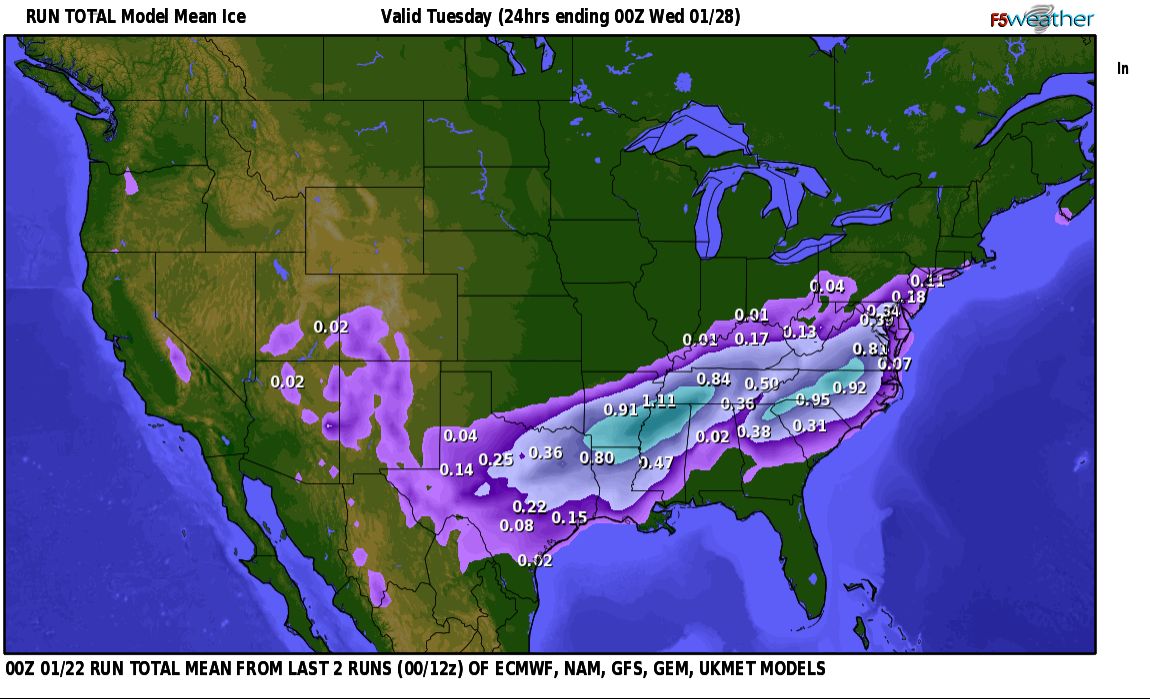
Here are the latest maps from F5Weather’s proprietary two-run, multi-model blend for what could become a historic winter storm. This is the 00z Jan 23 run.
A 12–15 inch snowfall appears increasingly likely across a massive corridor stretching from Oklahoma City → Louisville → Pittsburgh → Boston. That swath includes major metros such as Joplin, Cincinnati, Buffalo, Washington DC, New York City, and Philadelphia.
What may be even more disruptive, however, is the potential for catastrophic icing from freezing rain. Parts of the Southeast — including western and northern Mississippi, northeast Georgia, and extending toward Richmond, VA — could see ice accretion approaching or even exceeding 1 inch in spots.
For perspective, as little as 0.25" of ice is enough to bring down tree limbs and power lines. Given the widespread nature of this storm — combined with localized areas of extreme icing — impacts across the Southeast could be severe. If outages become widespread, restoration times will likely be prolonged, simply because of the sheer scale of damage.
If you live in any of these areas, take this storm very seriously. Be prepared for the possibility of extended power outages, loss of heat, and limited access to food or travel — potentially lasting several days.
Now is the time to prepare, as icing will begin in Texas starting mid-day Friday.
For the latest raw computer model forecast graphics, visit https://t.co/CB1e7ybMM2
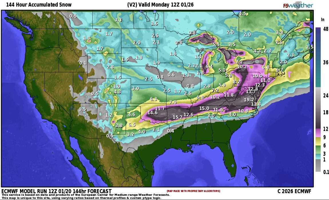
The major winter storm heading to the southern and eastern US this weekend is still on track although guidance has drifted the tracks north a bit. A foot or more of snow is looking likely from Oklahoma to Kansas, and then expanding in coverage across the Mid Atlantic and Northeast.
These are huge snow amounts, but the bigger story may be the ice storm setting up from Texas to the Carolinas and Virginia. A massive area of heavy icing, with some areas seeing over an inch of ice is possible. This will likely create prolonged power outages as the heavy ice takes down trees and therefore powerlines over a huge area.
The worst of it right now looks to set up near a line from Arklatex to Nashville, especially across northern Mississippi. Another heavy swath of ice looks to set up from Atlanta to Richmond, VA. But anywhere that sees a quarter inch of ice or more is going to have significant impacts.
Attached are forecast graphics from a 2-run model blend utilizing 5 deterministic models courtesy of https://t.co/NBFeHG1Guo
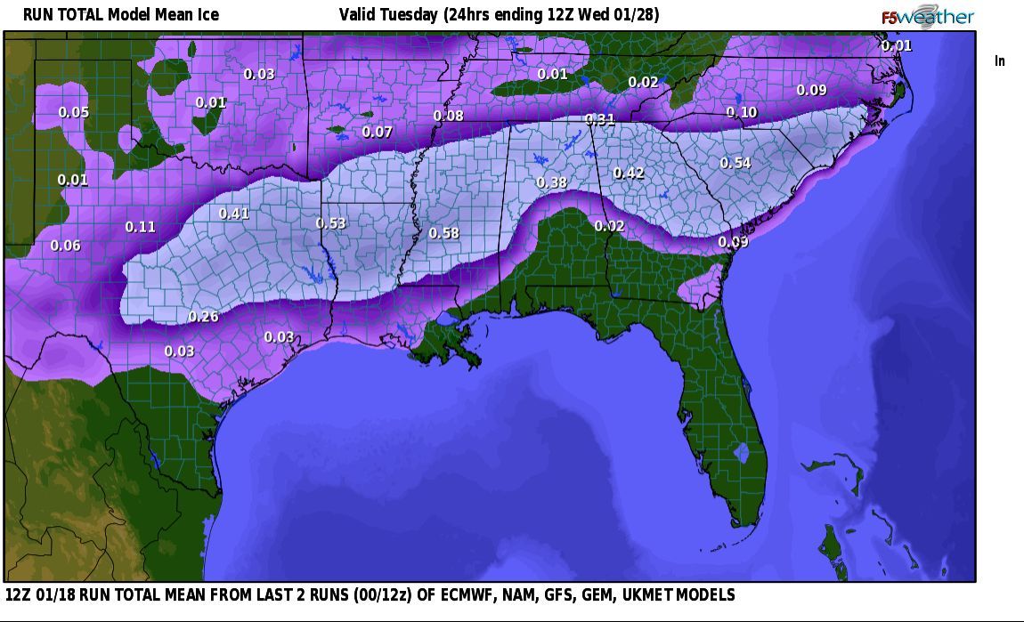
If the morning run of the European ECMWF has it's way, a major winter storm is heading to the southeast this weekend. Ice accumulations of a couple INCHES are depicted in a line from Texarkana to Atlanta. And just north of that line 15-20" of snow in a line from Oklahoma City to Nashville and Norfolk! Even if the exact track and values are not correct, the overall idea of this being a major storm should require your attention if you live in these areas.
Attached are morning model run depictions from https://t.co/NBFeHG1Guo
The coldest air of the season, and a major ice storm may be on the way for next weekend. See the latest model forecasts at https://t.co/HKn8D5xXY7
New & existing customers to F5Weather's computer model forecast maps can add on a year of subscription time for only $119.95 for pro, or $75.95 for basic level service! It's a non-recurring one time fee, so there are no surprising charges afterwards. Just enter coupon code WINTER at check-out.
Get simulated forecast radar, snowfall predictions, maps of every weather variable imaginable, tables of raw data values and more.
https://t.co/QMOeG97PhR
January 19th to the 25th will be a stereotypical winter week across most of the lower 48 states, with bitter cold, heavy snow and ice. A deep cold plunge across the central and eastern part of the country will foster heavy lake-effect snows across the Great Lakes. As polar air dips across the warm open waters, heavy snow will fall on the downwind sides of all of the Great Lakes.
Abnormally cold air, even for one of the coldest weeks of the year, will dip across the Upper Midwest towards the Southeast.
Next weekend, a strong storm is expected to develop in the south, potentially producing a widespread ice storm from central Texas to the Carolinas. This could be a significant icing event that needs to be watched. Just to the south of the icing, some isolated severe storms may be possible Friday & Saturday across southeast Texas towards coastal Alabama.
The west will be the place to escape to. Warm and sunny conditions are expected over the Southwest.
https://t.co/b6o616xJnG
Happy New Year's!
New & existing customers to F5Weather's computer model forecast maps can add on a year of subscription time for only $119.95 for pro, or $75.95 for basic level service! It's a non-recurring one time fee, so there are no surprising charges afterwards. Just enter coupon code WINTER at check-out.
Get simulated forecast radar, snowfall predictions, maps of every weather variable imaginable, tables of raw data values and more.
https://t.co/QMOeG97PhR