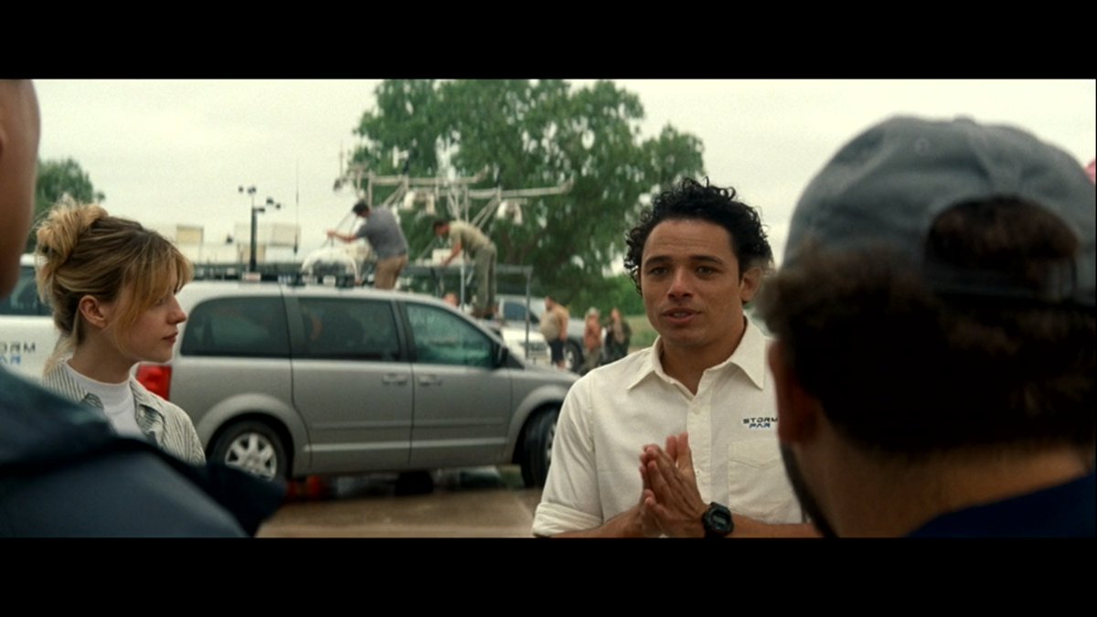
@Severity_RBX I've got a ton of reference material of Sean Casey's Subaru build. You can have it in exchange for consideration of adding my own vehicle. Yeah, it's a Dodge Caravan.... buuut It's a famous movie storm chasing vehicle now ;)
You may have heard that hundreds of employees were just cut from NOAA and the National Weather Service (NWS). These agencies were already critically understaffed, and these firings will have real consequences—for public safety, disaster response, and even the economy.
But here’s the bigger picture: This looks like the first step toward privatizing the NWS, which would be a disaster. Why? Because the NWS is a public service that keeps us all safe. Privatization could mean paywalls for tornado warnings, delayed hurricane alerts, and profit-driven weather forecasting.
🔎 Here’s why the NWS (and NOAA) should NEVER be privatized:
➡️ Private weather companies RELY on NWS data.
-The Weather Channel, AccuWeather, and local meteorologists don’t generate their own raw data—they use NOAA & NWS resources like satellites, radar, and observation stations. 📡
-Without the NWS, private companies would either have to build their own billion-dollar infrastructure or work with incomplete data. 💰
➡️ Public safety should NEVER be paywalled.
-The NWS provides free, immediate alerts for hurricanes, tornadoes, floods, and severe storms. ⚠️
-Privatization could mean delays in warnings, paid subscriptions for life-saving information, or companies selling critical data before the public gets access. 💲
➡️ The NWS is a national security asset.
-FEMA, the military, emergency responders, airlines, and shipping industries depend on NWS forecasts. 🛑
-A privatized system could prioritize corporate clients over public safety, leaving vulnerable communities without real-time warnings. 📊
➡️ The private sector would ignore rural and low-income areas.
-The NWS operates 120+ local forecast offices, including in rural areas that private companies would have no financial incentive to serve. 🌎
-A for-profit model could leave small towns with incomplete or delayed weather data. ⏳
➡️ Weather research & climate science would take a massive hit.
-NOAA and NWS are key players in climate research, hurricane forecasting, and extreme weather tracking. 🌡️
-Universities, farmers, environmental groups, and global partners depend on free, accurate weather data. Privatization could restrict access or commercialize it. 📉
➡️ The NWS is already funded — privatization would just make weather forecasting more expensive.
-Tax dollars already pay for the NWS, meaning everyone gets equal access to critical weather info. 💵
-If privatized, private companies would still rely on government-funded data but charge consumers and businesses to access it. ⚖️
➡️ International cooperation would be disrupted.
-The U.S. provides free weather data to other nations, helping global disaster preparedness. 🌍
-If that data is monetized or restricted, it weakens global storm tracking and emergency response efforts. 🚫
⚠️ The Bottom Line:
Privatizing the National Weather Service is dangerous, unnecessary, and purely profit-driven. Weather data belongs to everyone, not corporations. Cutting NWS staff is already putting public safety at risk, and if privatization happens, we will all feel the consequences.
This is a conversation we need to be having. If you care about public safety, disaster preparedness, and free access to life-saving information, share this post and make your voice heard. 🗣️💙
#ProtectTheNWS #NOAA #NationalWeatherService #PublicSafetyNotProfit #KeepWeatherFree ⚡
@donkeydownburst @skydrama@Thiellaos@MarkSefried @wx9jc I was too young and naive to get really bent up about missing that one. I don't even think I had radar at the time. Man, 20 years
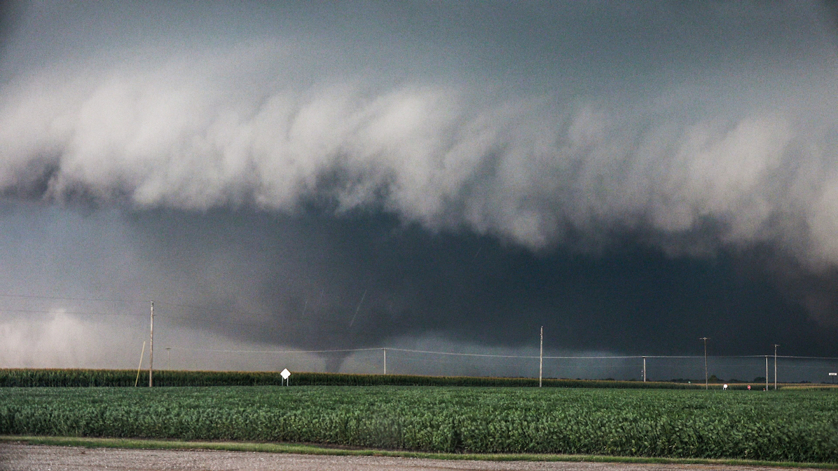
11 years since El Reno, we still chase Oklahoma, even High Risks. But we've changed since then. How we chase, where we chase, and who we are as chasers
https://t.co/UHCV6CWm7K
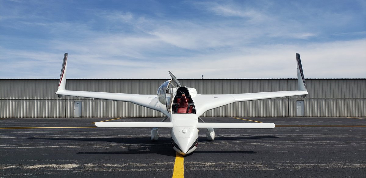
@JTAllen3@JLaDue @tlyzawx I totally would if I were closer! I just got down from a flight, and this would make a great platform for surveys with configurable camera mount locations. I flew over a couple of paths last season and could find some swirl marks in the corn
@OHWXisweird I wrote all the software to make those animations using c# and Direct3D. Those are Google map layers on that one, but I now use Mapbox to get the transparent road overlay layer and base terrain layer.
@aaronjayjack My stupid Subaru toasted two batteries sitting long enough in the garage. The electrical system is defective on several models: https://t.co/7xU2bKM1HL
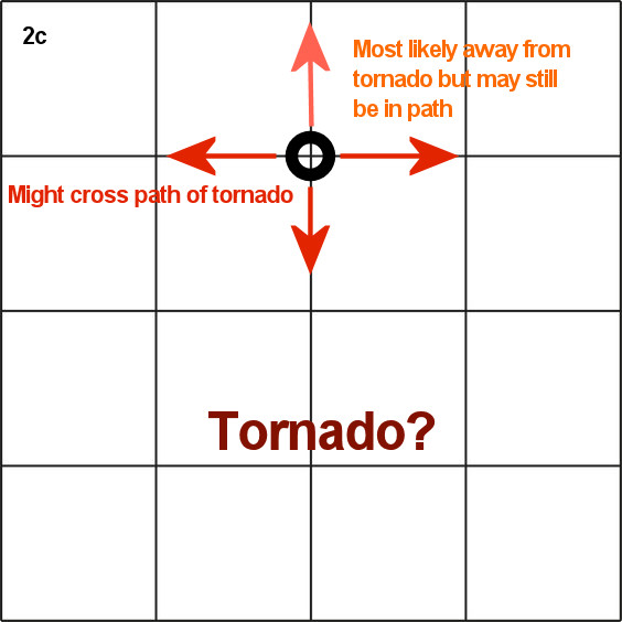
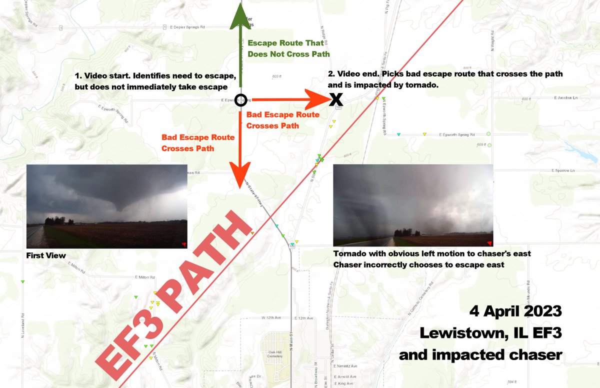
Join us live in a few minutes for a storm chasing safety briefing. I'll be discussing escape route planning and going over some scenarios you might find yourself in someday.
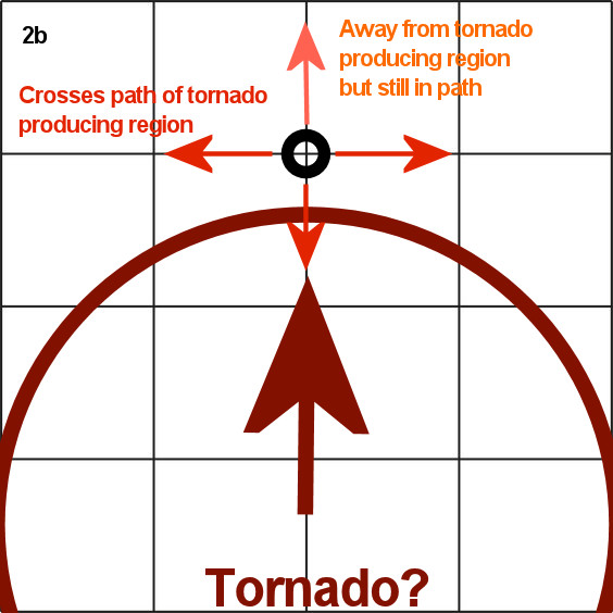
This is an issue of competency on the most basic level
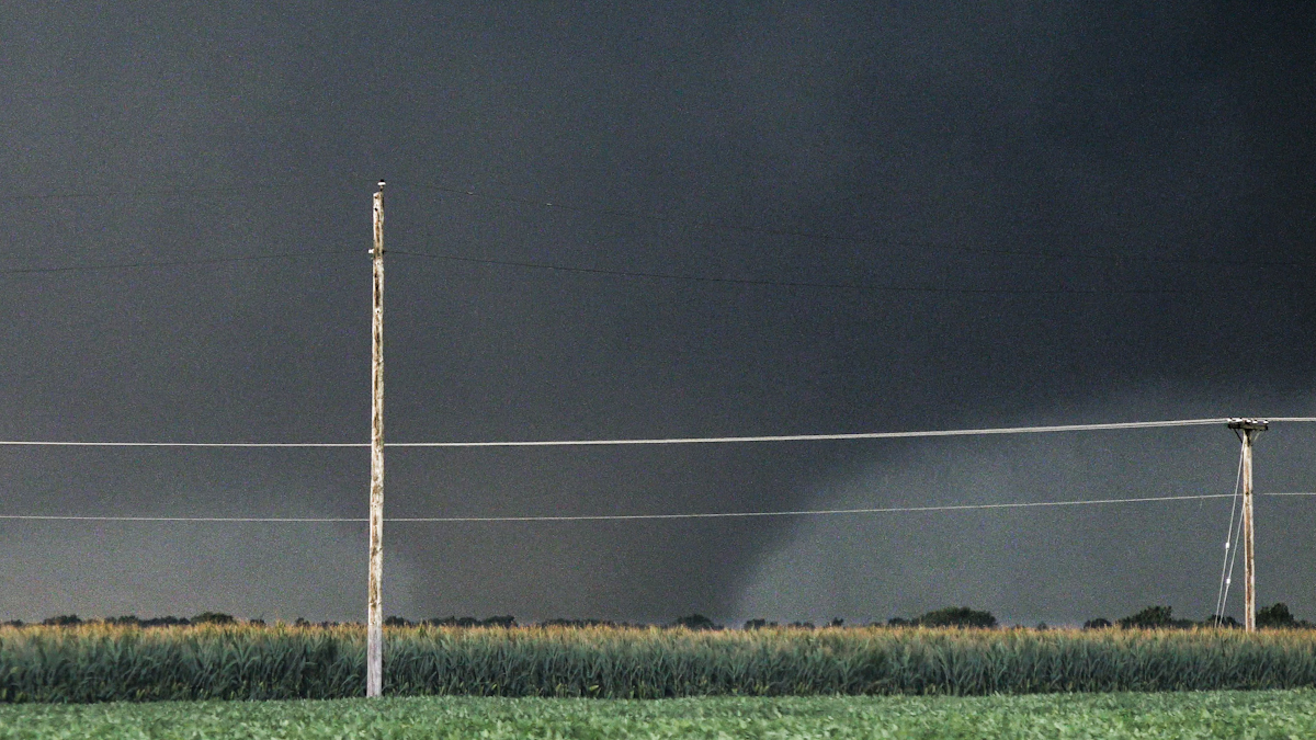
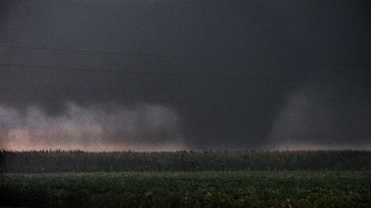
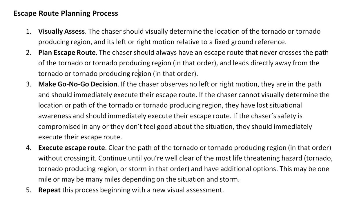
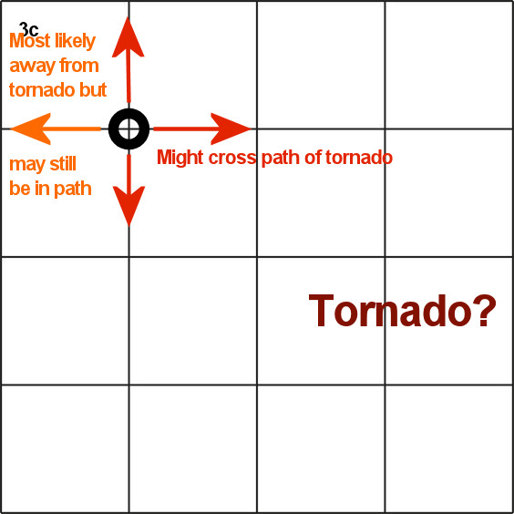
1. Escape as soon as you recognize you're in the path.
2. Escape away from the path, not across it.
Failure may result in death. All chasers need to understand this before they ever take to the road.
https://t.co/Np7whqalTP