The satellite 🛰️ and radar sequence shows the showery outbreaks of rain 🌨️ which have been spreading northeast today
Some thundery downpours ⛈️ developed, mainly near to the English Channel coast
#StormBetty is gathering to the southwest
As #StormBetty develops many areas should brace for a period of wet & very windy weather, bringing flooding & disruption🌧️🌬️
Watch out for warnings relevant to your circumstances as this storm develops over the next few hours⚠️⤵️
https://t.co/Xg3aMJlyuS
⛅ A dry afternoon for most, with plenty of sunny spells
🌦️ Showers developing across southern Scotland and northern England, which could turn heavy and thundery at times
🌡️ Feeling warm in any sun with light winds, and temperatures into the low twenties
Did you know that our daily Flood Guidance statements, and our twice monthly Flood Outlook products are available through @metoffice Hazard Manager https://t.co/IP5QIjY8LD & Resilience Direct @rd_gov https://t.co/VxpJS4oRQx #floodforecasting#flood#flooding#responders
The FGS provides a daily flood risk forecast to assist with strategic, tactical and operational planning decisions for:
the UK and Welsh governments
Category 1 and 2 responders
other organisations involved in emergency and flood response https://t.co/VGRTvro7yz
The Flood Outlook provides a flood forecast for the coming month in England and Wales. It is issued twice a month. The Flood Outlook is for planners who need to make decisions at a timescale of 6 to 30 days. https://t.co/5t5kHCtafZ
If you would like to understand more about the Flood Forecasting Centre's products and services, take a look at our training videos https://t.co/x22orhwn7K
The Spanish meteorological service @AEMET_Esp has named an area of low pressure #StormJorge
It will bring wet & very windy weather to the UK over the #weekend with up to 60mph gusts inland
Weather warnings are in force, keep up to date with the forecast ⚠️
Stay #WeatherAware
The last few hours have brought #rain to many parts, with #snow affecting parts of Northern Ireland, northern England and southern and central Scotland.
Warnings are in force, stay #WeatherAware
There are 96 #FloodWarnings in place across England and 1 #SevereFloodWarning in #Shropshire
With further rain expected throughout the early part of this week it's important to check your flood risk and know what to do in a flood.
👉 https://t.co/6sQvhutQ0p #Flood
The latest satellite image shows an area of low pressure developing as it heads towards the UK for tonight and tomorrow 🛰️
Weather warnings have been issued - Stay #WeatherAware
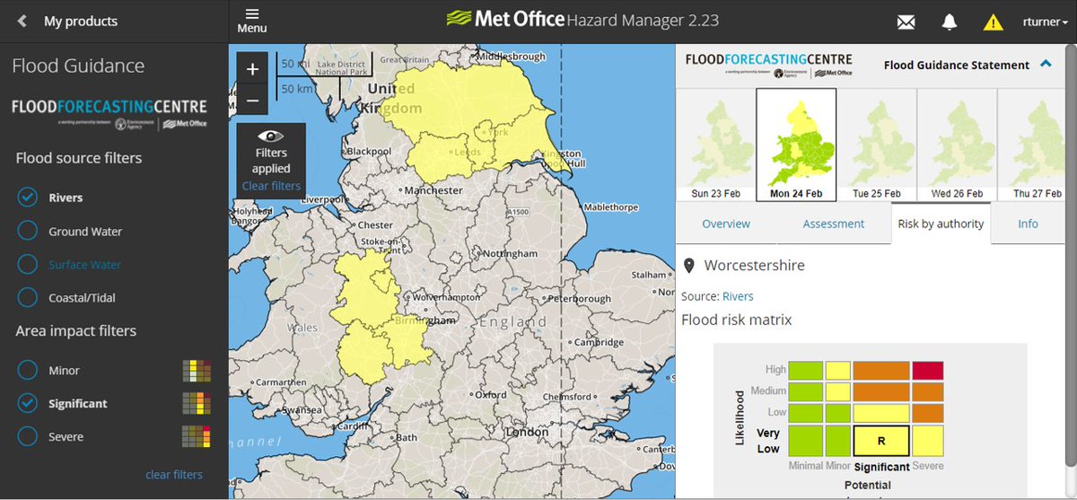
Remaining unsettled with continuing flood risk into next week; use the FGS on Hazard Manager to filter by flood source and forecast impacts to highlight the areas of concern to remain #floodaware
It will stay unsettled across the UK over the coming days, with colder air filtering in next week.
For latest warnings please refer to our website https://t.co/ClNLdOEvOV
Monday’s forecast indicates that an area of low pressure will affect the UK. We have issued Yellow warnings for this but the weather system is NOT a named storm and #StormEllen has currently NOT been named
For latest warnings please refer to our website
https://t.co/ClNLdOEvOV
More wet and windy weather will affect the UK on Monday from another low pressure system.
There’s some uncertainty about the exact position and track of the low and this will have an impact on the severity of the weather we see.
@aidanweather explains
#WeatherAware
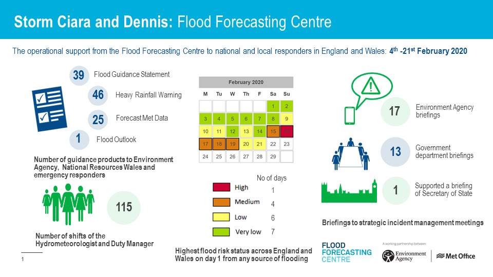
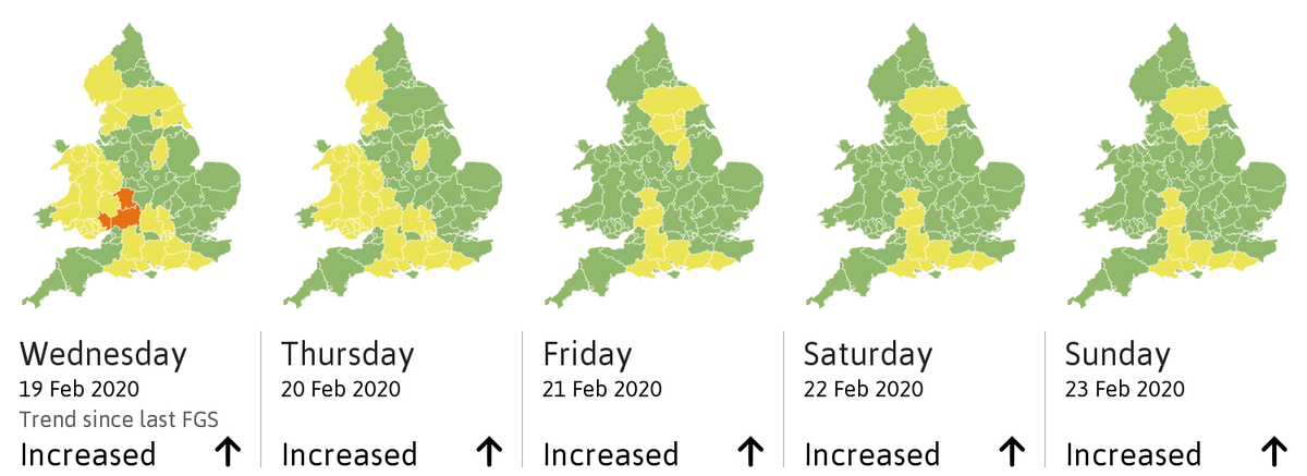
It remains very busy for our Cat 1 & 2 responder colleagues; a summary of our guidance to them to help communities right across England and Wales. The unsettled period continues so please remain #floodaware this weekend 22/23 Feb
Not us, but our data via the API feed which is automated to go out after every FGS issue with the summary headline and maps. Normally updated within an hour of issue.
May be a useful one to follow for the ongoing flood situation #floodaware
The overall flood risk is MEDIUM. Significant flooding impacts continuing along the Rivers Severn, Avon and Wye today. Spells of rain this week mean further significant flooding impacts are possible. See end of FGS for 6-10 day forecast.
https://t.co/8BDNluUtSi