Dipshits tried DMCA’ing me over allegedly stealing U.S. DoD classified imagery and getting me thrown into federal prison. Nothing happened to me, but hey, they’re fucked.
Heavily damaged Iranian hardened aircraft shelters due to U.S.-Israeli strikes during the 39-day war.
C: 35.685986, 51.337926
S: https://t.co/pqmAIPu3f2
🇮🇷 Zniszczone schronohangary w bazie Mehrabad w Teheranie. W hangarach stacjonowały Jaki-130, jednak samolotów nie widać, co wskazuje na to, że zostały one przebazowane w inne miejsce.
Israeli airstrikes on an Iranian F-4 and an Iranian F-5 aircraft.
C [F-4]: 38.123313, 46.258141
C [F-5]: 38.129665, 46.256568
S: https://t.co/dBJKU4geJe
כלי טיס של חיל-האוויר תקפו לפני זמן קצר שני ��טוסי קרב מוכנים להמראה מסוג F5 ומסוג F4 של משטר הטרור האיראני בשדה תעופה בתיבריז שבמערב איראן.
התקיפה בוצעה על מנת לפגוע בפעילותו של חיל האוויר האיראני ובכדי להעמיק את הפגיעה במערכות ההגנה של המשטר.
צה"ל ממשיך לתקוף תשתיות של משטר הטרור האיראני בכדי לפגוע במשטר ולסכל איומים על עורף מדינת ישראל
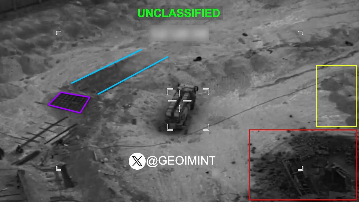
Despite it being containerized and only claimed to be a missile launcher, I would say it likely was one, given the characteristic yellow-brown smoke often associated with hypergolic liquid propellants.
תיעוד מיוחד מתקיפה מדויקת של חיל-האוויר לעבר משאית ששימשה כמשגר טילים בליסטיים נייד במרחב תבריז.
המשגר הושמד ובכך סוכלו מתווי ירי טילים לעבר מדינת ישראל ממערב איראן.
תיעוד מיוחד ממטוס קרב מסוג ״אדיר״ (F-35i): הושמד משגר טעון של משטר הטרור האיראני במערב איראן
בתקיפה שבוצעה על ידי מטוס קרב מסוג ״אדיר״ (F-35i) במרחב כרמאנשה שבמערב איראן, הושמד משגר טעון עם טיל קרקע-קרקע.
חיל-האוויר ממשיך לפגוע באתרי השיגור ומשגרי הטילים על מנת להסיר איומים על מדינת ישראל.
@geodesicradome No, as you can see, it says June 6 onwards. That’s when my summer break starts, and I sincerely can’t be bothered being on Twitter during it. As you know, I have a life, unlike many.
𝐆𝐨𝐨𝐠𝐥𝐞 𝐃𝐨𝐫𝐤𝐢𝐧𝐠 𝐟𝐨𝐫 𝐆𝐄𝐎𝐈𝐍𝐓
Before starting a geolocation task from zero, check if someone has already mapped it.
Whether you are investigating military, civilian infrastructure, routes or conflict zones, KML files can give you a head start with mapped locations, coordinates, routes and descriptions.
Adjust the following query as per your requirements:
(filetype:kml OR inurl:.kml) (Burma OR Myanmar) ("destroyed villages" OR "human rights" OR conflict)
Open the KML in Google Earth and start exploring as shown.
#OSINT #GEOINT #GoogleDorking
While the Iranian regime indiscriminately targets civilians with missiles and drones, U.S. forces continue to aggressively hunt and destroy Iranian missile launchers with precision.
A missile fired by the Islamic Republic fell moments after launch in Hamedan province, according to video sent to Iran International. The footage shows the projectile dropping shortly after takeoff, as a pro-government onlooker reacts with audible frustration.
U.S. forces are striking targets to degrade the Iranian regime's military infrastructure and capabilities that have threatened American troops and regional partners for decades.
Please for the love of god just fire whoever is responsible for releasing airstrike footage in the IDF.
Literally everybody knows that the cameras are way better than this, except the guy in the IDF that says "They cannot know that, we need to degrade everything to hell"
Iranian Army Air Defense Force, likely electronic warfare or communications system, intact and deployed after the 2026 Iran war.
C: 35.550502, 51.449257
S: https://t.co/rdZaNL9RE2
Wreckage of two components (1× direction-finding and detection station, 1× information processing station) of a Russian-supplied Avtobaza-M ELINT system in Iranian service destroyed during the 2026 Iran war.
C: 35.551353, 51.447718
S: https://t.co/rdZaNL9RE2


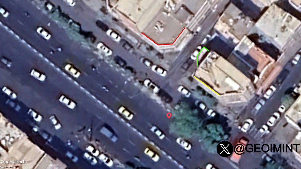
![GEOIMINT's tweet photo. Israeli airstrikes on an Iranian F-4 and an Iranian F-5 aircraft.
C [F-4]: 38.123313, 46.258141
C [F-5]: 38.129665, 46.256568
S: https://t.co/dBJKU4geJe https://t.co/wmJ4T5Ts7n](https://pbs.twimg.com/media/HJltbugWAAMIMuC.jpg)


![GEOIMINT's tweet photo. Israeli airstrikes on an Iranian F-4 and an Iranian F-5 aircraft.
C [F-4]: 38.123313, 46.258141
C [F-5]: 38.129665, 46.256568
S: https://t.co/dBJKU4geJe https://t.co/wmJ4T5Ts7n](https://pbs.twimg.com/media/HJltcM0WgAQZ8Eb.jpg)
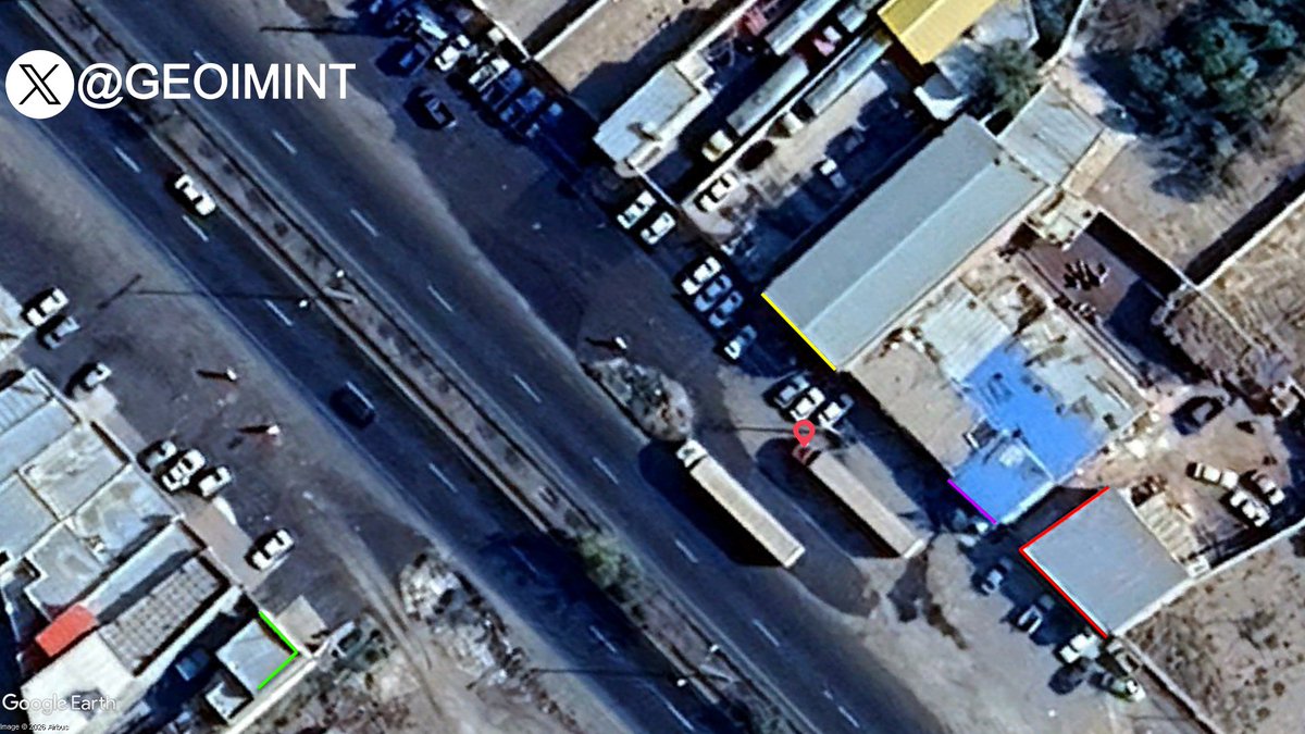


![GEOIMINT's tweet photo. Geolocation of an Iranian ballistic missile launch failure.
C: 34.906643, 48.410153
C [POV]: 34.899231, 48.421203
S: https://t.co/4a4Vc88tjm https://t.co/9opFqgpuYR](https://pbs.twimg.com/media/HJJvYdWXEAA1phh.jpg)


