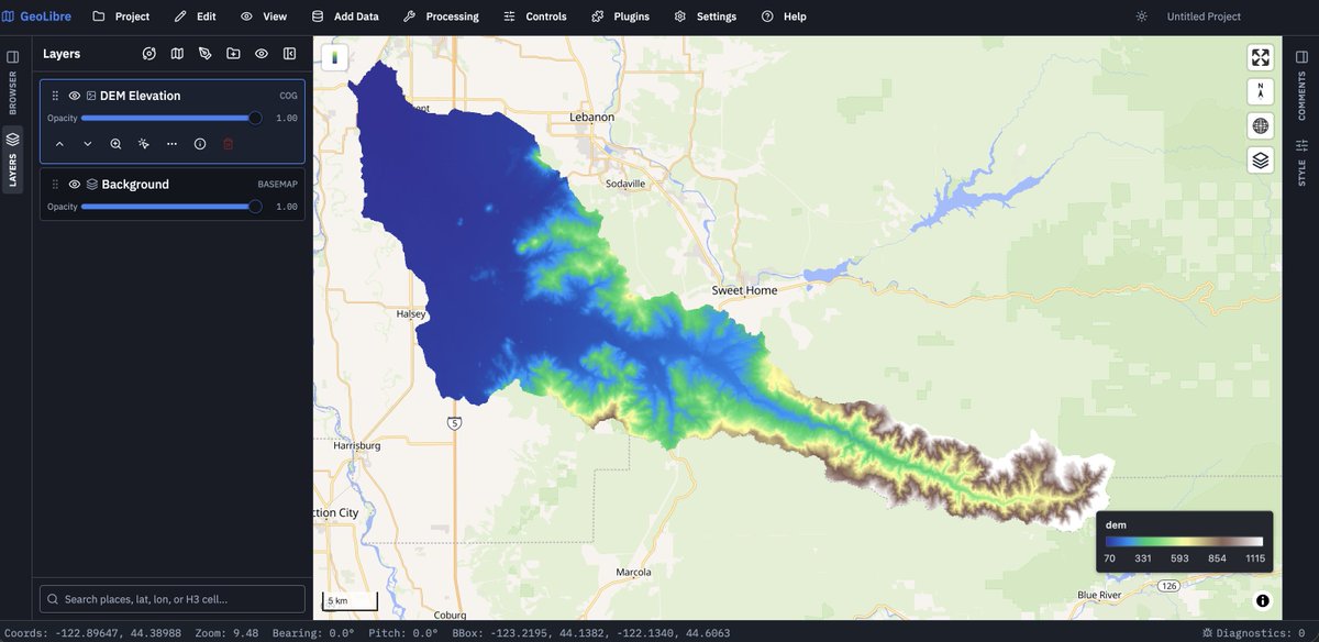
Open remote data with a URL, and the new "Open in GeoLibre" badge
You can now share a working map without asking anyone to install anything, sign in, or upload a file. Point GeoLibre at a hosted dataset and it opens as an interactive map in the browser:
https://t.co/dG1ph8unqm
What you can open
- Vector: GeoJSON, GeoParquet, PMTiles, or a ZIP archive holding several GeoJSON files, where each file becomes its own layer.
- Raster: Cloud Optimized GeoTIFF, and raster PMTiles.
- API: any REST endpoint that returns a GeoJSON FeatureCollection or a ZIP of them. The endpoint does not need a `.zip` suffix; the response is recognized from its headers or file signature.
- Bring your own styling
COG, GeoParquet, and PMTiles all stream over HTTP range requests, so a multi-gigabyte file does not have to be downloaded before you can explore it.
Everything here runs client-side. There is no account, no upload, and no server-side processing; data is fetched by your browser and stays there.
Try it out
- Documentation: https://t.co/eM9IbVd9gN
- The badge: https://t.co/xU9YpDmMMp
- GeoLibre Web: https://t.co/8gMtkVtNcU
- A vector example: https://t.co/fWgE4tl0Vp
- A raster example: https://t.co/WggLiErmsx
#GIS #Geospatial #OpenSource #OpenData #MapLibre #GeoLibre
Join GEO Aquawatch Tommorow on March 19th at 12:00 UTC/3PM EAT as we celebrate 2 extraordinary early career scientist winners of our Early Career Society’s 3rd Annual Water Talks! Meeting link: https://t.co/ktdG4gkAaO
Join GEO Aquawatch on March 19th at 12:00 UTC as we celebrate 2 extraordinary early career scientist winners of our Early Career Society’s 3rd Annual Water Talks!
Meeting link: https://t.co/ktdG4gkAaO
Join GEO Aquawatch on March 19th at 12:00 UTC as we celebrate 2 extraordinary early career scientist winners of our Early Career Society’s 3rd Annual Water Talks!
Meeting link: https://t.co/ktdG4gkAaO
GeoAquawatch Invitation
Join GEO AquaWatch on March 19th at 12:00 UTC as we celebrate 2 extraordinary early career scientist winners of our Early Career Society’s 3rd Annual Water Talks!
Moderated by Duy Nguyen and @IamWanjohichris@geoaquawatch#earlycareer#waterquality#eo
This Saturday, GEE Developers Community Nairobi is privillaged to host Amirhossein Ahrari for a workshop session on Satellite Embedding Mapping using K Means Clustering.
📅 Date: 27.09.2025
📷 Time: 4 PM EAT (Nairobi Time)
Link: https://t.co/yZbmQL0kwt
#google#kenya
Hello GIS & Climate innovators, @GeeDevs is delving into the world of #geoai with @codeforgeo. Please join us to learn..event link here's
Time: 1600 EAT (Nairobi Time)
Meet Link: https://t.co/Qiuw0Q6hz4
Hello GIS & Climate innovators, @GeeDevs is delving into the world of #geoai with @codeforgeo. Please join us to learn..event link here's
Time: 1600 EAT (Nairobi Time)
Meet Link: https://t.co/Qiuw0Q6hz4
Early career individuals (including Master’s and PhD students, new professionals, and technical staff), especially in under-represented regions are highly encouraged to apply.
Early career individuals (including Master’s and PhD students, new professionals, and technical staff), especially in under-represented regions are highly encouraged to apply.
We’re excited to share an excellent opportunity for you to present at the @geoaquawatch Water Talks 2025/2026!
Simply submit your abstract by 31st August 2025.
Apply here: https://t.co/TLMjadXrme
We’re excited to share an excellent opportunity for you to present at the @geoaquawatch Water Talks 2025/2026!
Simply submit your abstract by 31st August 2025.
Apply here: https://t.co/TLMjadXrme
You want to..
1. Work with raster data using #Earth#Engine in #BigQuery?
2. Expand BigQuery's geospatial capabilities with Earth Engine raster analytics
3. Export raster data to BigQuery?
Meet Link: https://t.co/Qiuw0Q6hz4
@EarthOutreach@googledevs@googleafrica