The forecast for next week in one word, YUCK! 90s for highs and lows in the low to mid 70s all week...enjoy the less humid air today through Saturday because it gets swampy next week! #miwx#inwx
if I had a nickel for every time a Michigan coach accused of widespread cheating bailed for the professionals after winning a national title, I'd have 2 nickels.
which isn't a lot but given the school it's not strange at all that it's happened twice
Our survey team has found EF-3 damage in Kouts, Indiana. They are continuing to survey the area.
We also have teams near Dwight, IL, Streator, IL, and Bartlett, IL. Additional updates will be coming soon. #ILwx#INwx
Public service announcement:
Nadocast outlooks determine the probability of a tornado at a point. Not the intensity of a tornado. An EF-5 and an EF-0 will have the same probability without a hatch contour, which suggests potential intensity. What the 14z nadocast model suggests there is a 60% chance of a tornado in IL. Yeah, I agree.
Here we have the 14z and 12z nadocast runs, respectively. Notice the lack of an EF-2+ contour on the 12z run (14z run doesn't do intensity forecasts). What this tells me as there may be a QLCS weak tornado spam as a likely possibility with a low chance of an EF-2+ tornado.
Use your tools responsibly and communicate effectively, chasers and mets.
In the wake of the storms, strong non-thunderstorm wind gusts have developed and are expected through the afternoon. Most of the area in a Wind Advisory withwind gusts to 50 mph, but a High Wind Warning has been issued for far NE IL for gusts up to 60 mph is possible. #ILwx#INwx
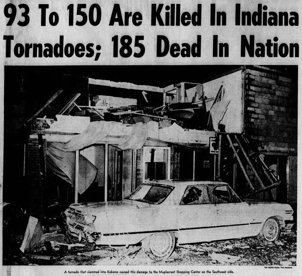
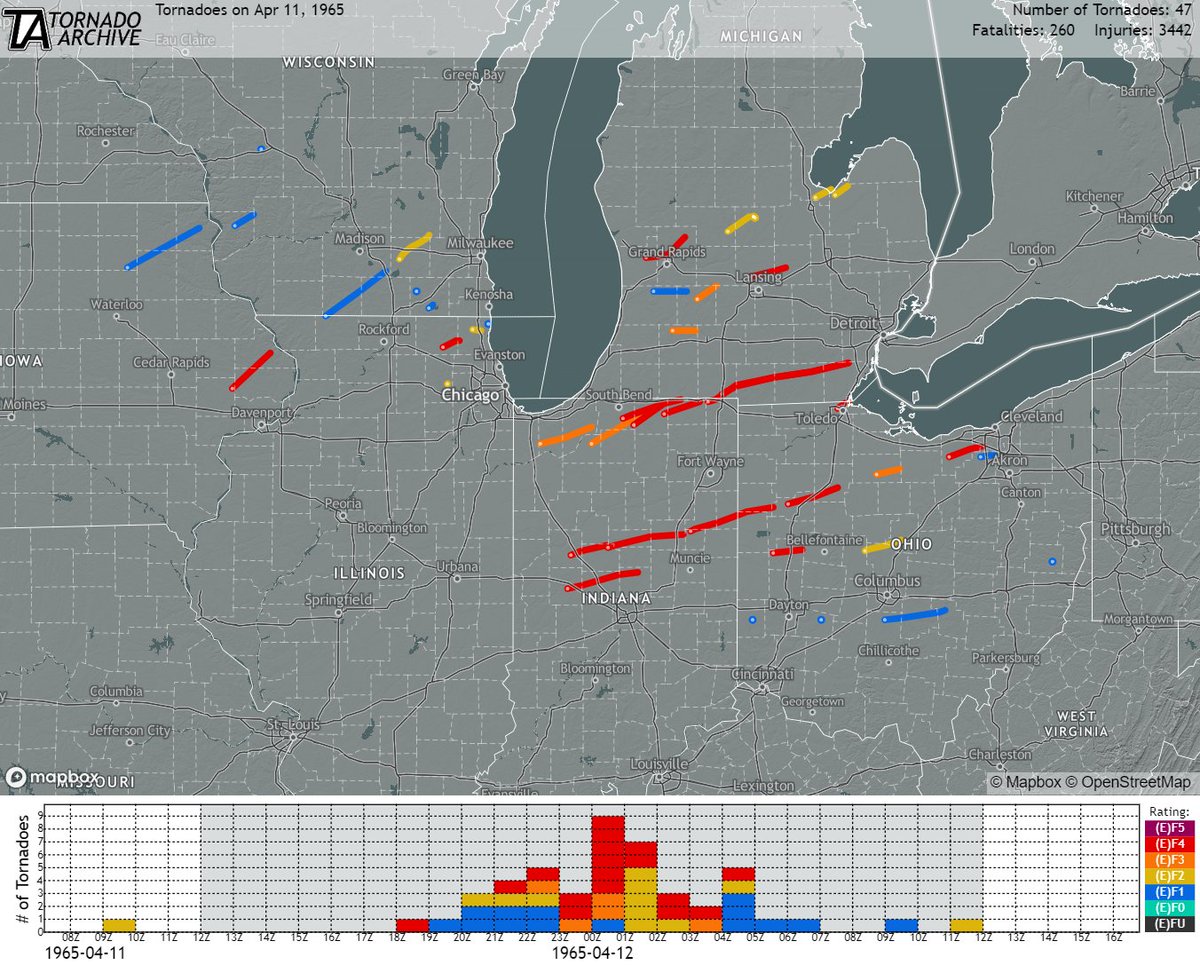
April 11, 1965:
One of the worst tornado outbreaks in US history struck the Great Lakes region. Nearly four dozen tornadoes (17 of which were rated F4) slammed numerous towns and cities, resulting in ~260 fatalities, >3400 injuries, and billions of dollars in damage.
#wxhistory
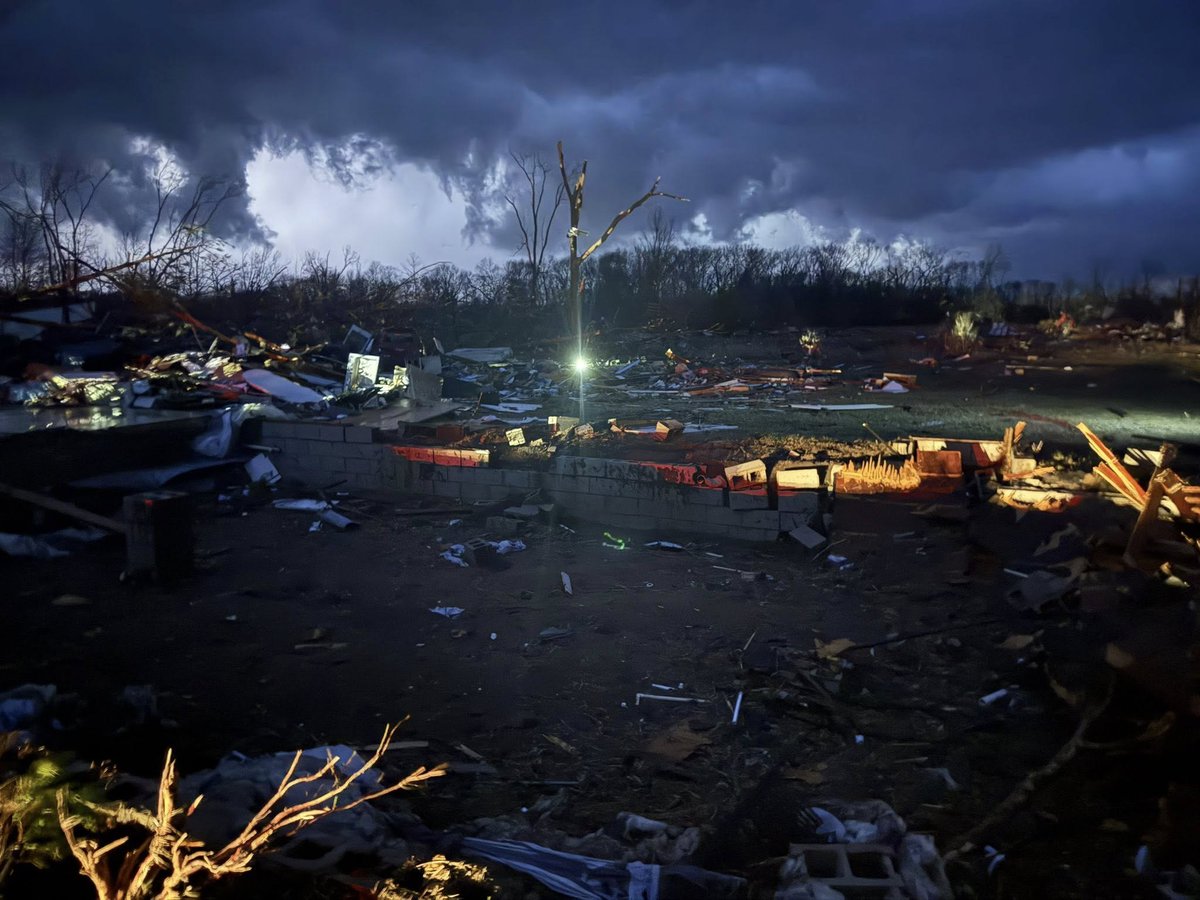
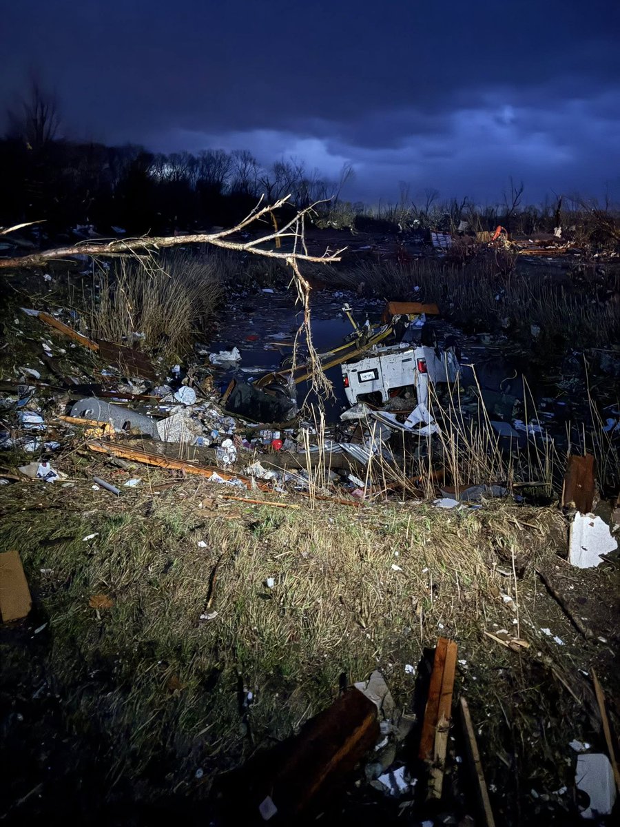
MAJOR DAMAGE west of Lake Village, Indiana.
According to the poster, JP Midwest Storm Chaser, there are people missing and 2 homes gone.
https://t.co/DVScVtIHcU
@ChasingWConnor From an inside ballpark it makes total sense but for us broadcast peeps it’s gonna be fun explaining the level 3 out of 5 risk with a level 2 out of 3 hatched area for (fill in the blank hazard here) 😵💫
Ignore the exact placement of the storms but you get the idea. Could be a LONG day tomorrow along & to the south of the warm front. Stay weather aware tomorrow, folks! #INwx#ILwx
PSA!!! Tomorrow (Tuesday, March 10), Indiana will have a statewide tornado drill at 10:15a EDT (9:15a CDT). There is **NO** SEVERE RISK in the morning. If you hear sirens in the morning, that’s a good thing.
There *IS* a risk of severe weather in the evening & overnight.
The Union City, MI preliminary EF-3 tornado with max wind speeds of 160 mph is the earliest EF-3+ tornado on record in the calendar year for Michigan. It is also the strongest tornado to occur in Michigan since an F4 struck Kalamazoo and Eaton Counties on April 2, 1977.
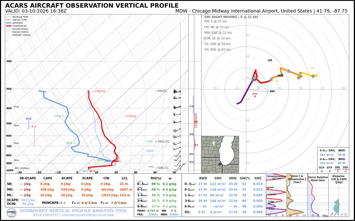
There is an Enhanced Risk (level 3 of 5) for severe weather on Tuesday, March 10th. Scattered supercells may develop as early as 5-8 PM EDT Tuesday evening and continue into the early overnight hours. The main threats will be hail up to 2" and tornadoes. #INwx#MIwx#OHwx
@nilwxreports I fear Tuesday could be a very long day for N. IL & Michiana. E-to-W warm fronts are diabolical, I said this to some friends today…Friday may have been the warmup act for Tuesday. And I hope I’m wrong. 😬
Sct'd lake effect snow showers, some briefly heavy, will continue thru 7 PM in the highlighted areas. Under the heavy snow showers, expect reduced visibility, snow covered roads, & hazardous travel. Conditions will likely vary substantially over short distances. #ilwx#inwx