I would expect fire season across the interior West to kick into high gear quite soon, with at least 6 consecutive upcoming days or critical or near-critical fire weather (a mix of hot, dry, windy, plus some dry lightning) aligning with widespread severe to extreme drought.
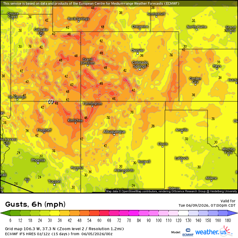
Models are showing potential for a major fire weather event for the SW next Tuesday. They are showing widespread 25-30 mph winds with RH in the single digits. Fuels will be dried out by multiple preceding days of hot, dry and windy conditions. #azwx#utwx#cowx#nmwx
#Border6Fire [update 4:00 p.m.] The fire is now 300 acres and is 0% contained. The fire continues to spread at a critical rate, requiring extended attack operations.
No tsunami is expected following a magnitude 6.0 earthquake that occurred about seven miles to the east-southeast of Honaunau in the South Kona area of Hawaii Island. https://t.co/9CzMrwNm7c
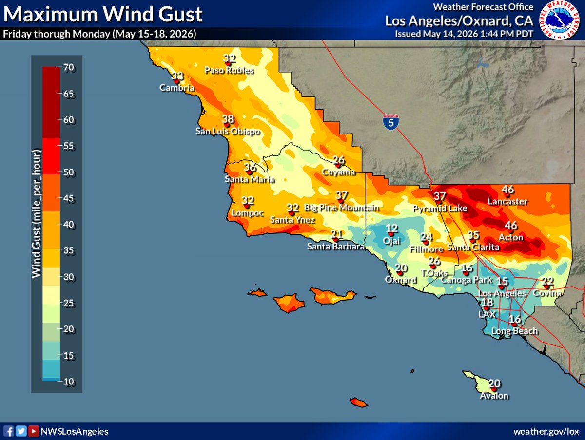
The Sandy Fire in Ventura county California has grown to 1,364 acres
Evacuation warnings have been expanded into LA county. Firefighters and night aviation continue to work.
This is a early season wake up call for Southern California.
The fuels are ready.
📷: @SeanStanley805
#SandyFire in Ventura County as of 5:30 p.m. on Monday 5/18 from the Oat Mtn South 2 ALERTCalifornia camera. Look to @VCFD_PIO for updates and evacuation information. See conditions live on multiple cameras at: https://t.co/xZNcsianLN
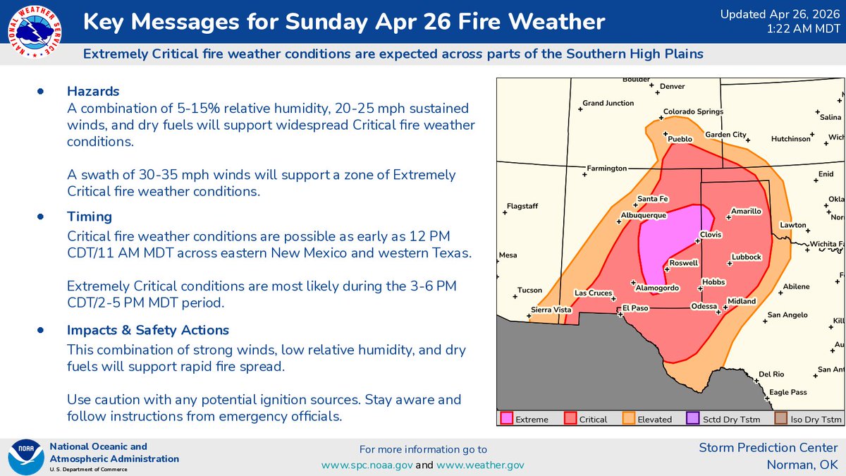
11:04am CDT #SPC Day1 #FireWX Extremely Critical: portions of extreme eastern new mexico, extreme southeastern colorado, southwestern kansas, and parts of the texas and oklahoma panhandles https://t.co/Sz3kci5ng7
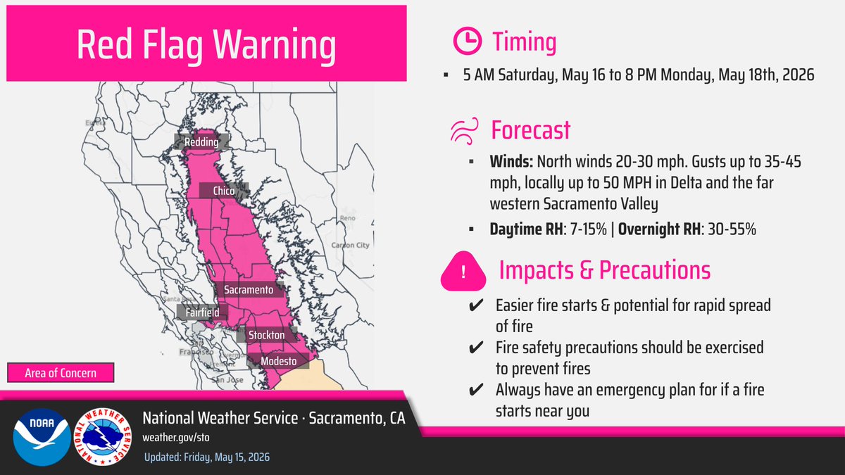
A Red Flag Warning has been issued for the Valley and Delta area from 5 AM Saturday to 8 PM Monday for the combination of low humidity and gusty winds.
Please review the warning for more details and exercise caution for those with plans over the next several days! #CAwx
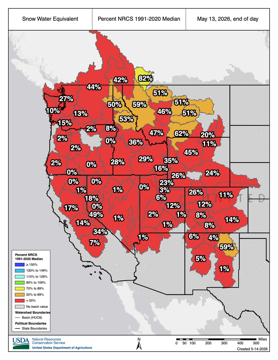
May Snow Drought Update
West Braces for Critical Water Shortages After Unprecedented Snow Drought
Record low water supplies are forecasted in many locations, reflecting the impacts of this year's snow drought, long-term drought, and record warmth.
https://t.co/dg1HnAviOw @NOAA
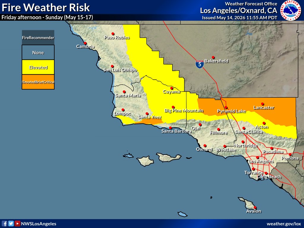
Windy with elevated to brief critical #FireWx conditions this weekend:
* W-NW winds gusting 35-50 MPH interior sections and western Santa Ynez Mountains
* Min RH 8-15% interior sections except 20-30% SW #SantaBarbara county
* High risk of fast-moving grass/shrub fires.
#CAwx
Heat will be building across the West into early next week. Widespread high temperatures may near or break daily records Monday and Tuesday. Expect high temperatures in the low 100s across the Southwest into the California Valleys and 80s/90s into the upper Mountain West.
Still looking like a very warm #MothersDay weekend for #SoCal:
- Highs 90-100 away from the coast Sun-Mon
- Elevated #FireWx conditions Fri-Tue
- Not just grass fire potential
- Min RH 8-15% interior sections
- SW-NW winds 10-20 MPH Gust 30 MPH
Most of the Lower 48 is in drought.
Notable exception: a swath of that runs from Central TX, through the Midwest, to the Northeast.
That area has seen 100-300% of normal precip in the last 60 days. Much of the Lower 48 has seen less than 50%. https://t.co/mljsjQE3B9 @NOAA
Welcome rainfall is on the way for parched areas of the Southeastern U.S. through the rest of the week. More is needed to alleviate the drought, but any rain is welcome to help knock down multiple wildfires that have erupted across the region.
https://t.co/VyWINDk3xP
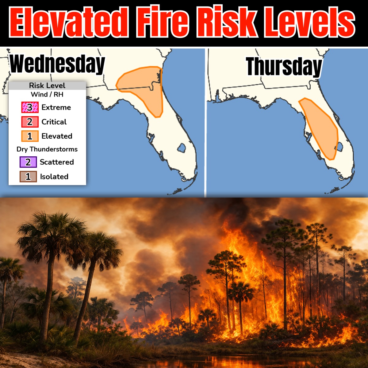
Low humidity and dry conditions have increased fire risk levels again for parts of Georgia and Florida the next several days. Wednesday/Thursday areas here. Likely watching Friday/Saturday too before frontal line rains reduces chances. https://t.co/Hk3pbO7x8H
⚠️🔥 Strong gusty winds and low relative humidity values are forecast to create Critical fire weather conditions across the High Plains tomorrow (Wed 4/22). Be sure to follow local fire restrictions and avoid creating sparks.
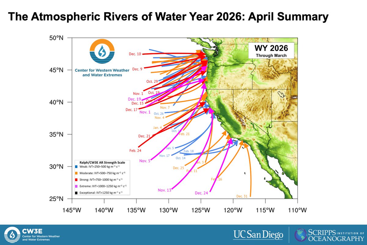
56 #AtmosphericRivers made landfall along the U.S. West Coast during the first 6 months of Water Year 2026. Stark differences in AR activity between October-December (14 strong or greater ARs) and January-March (only 3 strong ARs) helped explain the anomalously wet/dry conditions during those periods.
Read the full summary here: https://t.co/wavv0waI7k.