WEATHER AWARE: @NWS_BaltWash has placed #HoCoMD under a Moderate Risk (level 4 out of 5) for severe weather today, 3/16, due to widespread & intense severe storms forecasted to move across our area this afternoon/evening. A squall line, which is a line of t-storms that precedes a cold front & is often characterized by high wind & heavy rain, is expected to develop early afternoon. While squall lines tend to move thru an area relatively quickly, these systems bring a higher potential for damage. Wind gusts associated w/ this system could reach upwards of 70-80 mph, resulting in the potential for downed trees & power lines. Large hail & isolated tornadoes are also possible. The primary window of concern is currently 3-7 pm. (1/2)
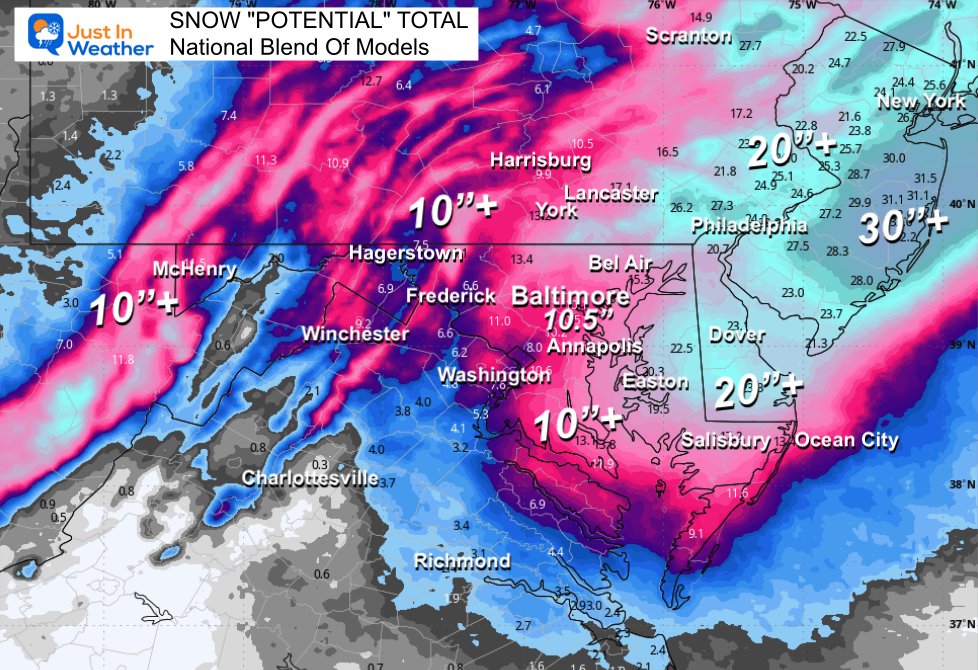
WEATHER ALERT: @NWS_BaltWash has issued a WINTER STORM WARNING for Howard County, in effect from 3:00 p.m., Sunday, February 22nd to 10:00 a.m., Monday, February 23rd. While snow may begin Sunday morning, the heaviest snow and coldest temperatures are most likely late Sunday afternoon through early Monday morning. Travel could be very difficult, especially Sunday night into Monday morning, impacting the Monday morning commute. Total snow accumulations of five inches or more are possible.
We need to talk and I will be updating my snow call HIGHER (as I suggested)
‼️ ❄️ The Blizzard Warning was EXPANDED to Maryland's Easter Shore: Talbot and Caroline CO.
💨Heavy Snow plus winds OVER 35 mph for at least 3 hours.
⛄️ ⛔️ This will be a HEAVY WET SLUSHY SNOW! Get Help Shoveling!!!
⚠️ ❄️ Winter Storm Warning Central Maryland/Central Pennsylvania: Includes Metro Baltimore/Annapolis to Southern Maryland. Also Garrett Co.
⭐️Winter Weather Advisory Metro Washington.
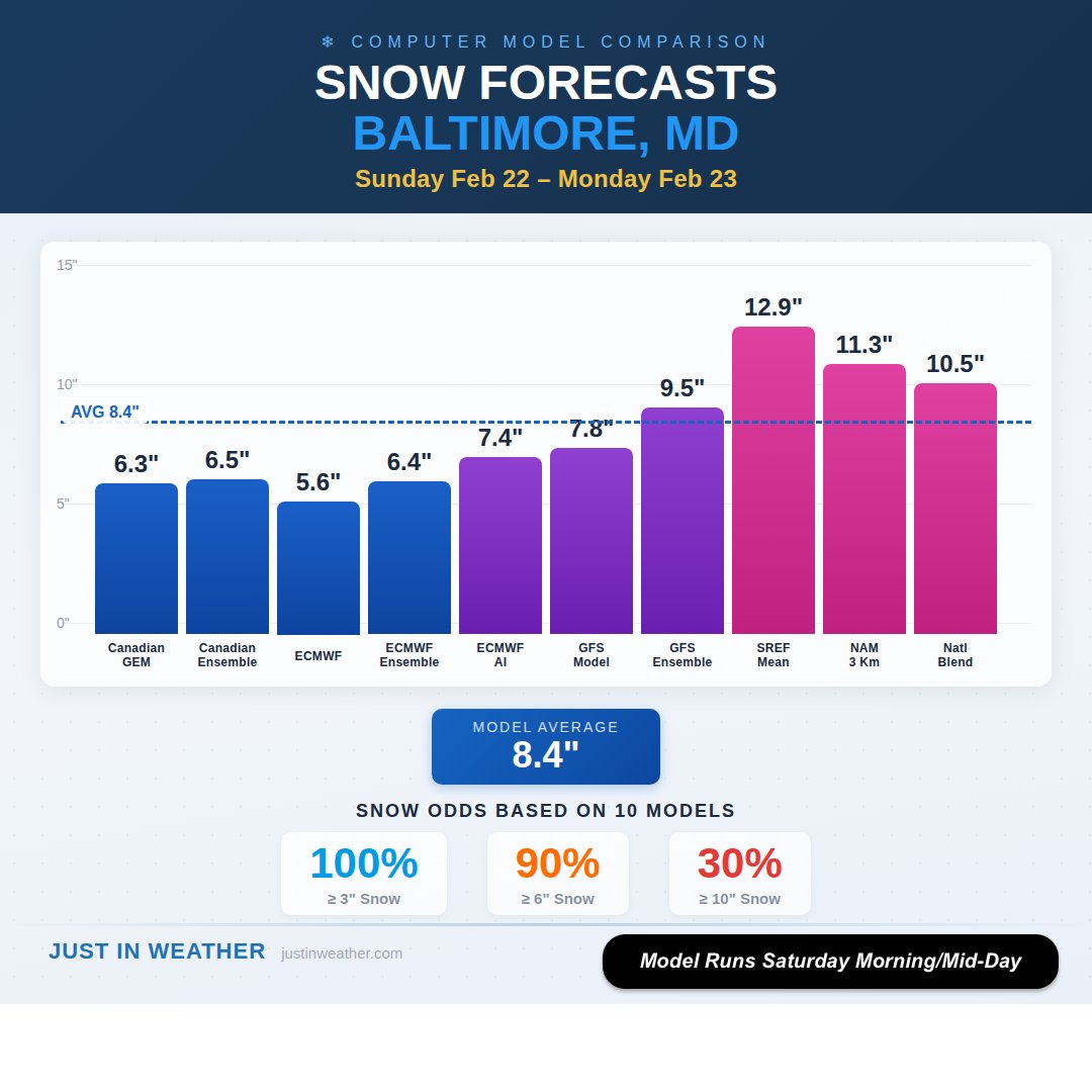
📊 Latest Snow Models For Baltimore:
Average 8.4"
📏 3"+ = 100%
📏 6"+ = 90%
📏 10"+ = 30%
👉These may be skewed by the GFS and other American Models.
💁🏻♂️Here is just a sample of the NWS National Blend of Models Compared to The European AI Ensemble (50 member blend).
📝 I will have my update later. I have other obligations to tend to first.
👉🔗 My Prior Report Using the NAM 3Km Model to highlight the blizzard development
https://t.co/sf8oWTCAZZ
SUNDAY STORM UPDATE: First thoughts...Should get at least some accumulating snow. Good chance for at least 1-2" with the high end being 3-4". Will have a better idea Friday. ���
Sunday Night Snow Forecast Challenge With Stronger Trend On European Model
I had to scrap my entire report and analysis because I wanted to show you this interesting development.
🦄 Yes, the GFS model plots looks like a pipe dream and it is an outlier.
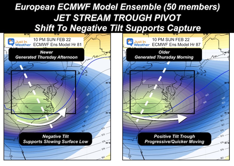
🇪🇺 The ECMWF Model is the one I was leaning towards, and it already did have a few inches of snow for us.
It has been Trending CLOSER and STRONGER.
💪 While the NOAA Outlook expanded their risk for heavy snow across Central Maryland, This new Experimental Product Increased the “Odds” For A Winter Storm Warning To Be Issued Sunday Night
🌀 The energy is now in California tonight.
💻 Still a contrast between the Canadian Bomb Cyclone and European Models less impressive.
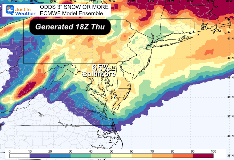
🎲 Map of Odds of 3” or More Snow have increased!
📊 Comparing Snow Totals for Baltimore. I Still DO NOT Endorse snow amounts more than 3 days out, so this is simply academic to show how I expect ALL the numbers to change.
👀 See why I have these numbers for Baltimore
1” = 100%; 3” = 57%; 6” = 29%
READ MORE 🔗 👉 Full Report
https://t.co/Cwc85xrQoK
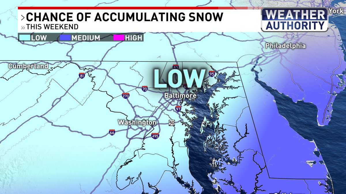
Thursday morning update on this weekend's snow chance: low chances for big impacts around Baltimore. Blustery weekend here with a dusting of snow possible south and east. Highest chances for snow, strong winds, and flooding... at the beaches.
#Fox45#mdwx
Sunday Snow: "What does it mean for me?"
Here is a quick overview:
🔪 A SHARP CUTOFF Of snow will put on a show in Maryland. Light snow "might" reach between Annapolis and Baltimore. The odds favor South of Annapolis/ US-50.
🤔 If there is any shift west or north, it would show up today on the modeling.
Here's what I have had since early this morning:
🎲 ❄️ Maps here show the Odds of 1"+ or 3"+ snow from the European Ensemble Members. I will have a more detailed look later.
💻 I've include the ECMWF Snow Forecast form the deterministic model plot to help illustrate expectations.
⚠️ ❄️ Winter Storm Watch INCLUDES Ocean City MD, Some Lower Eastern Shore Counties, and more of Southeast VA, Eastern North and South Carolina.
🏖️ 💨 Winds by the coast may reach 55 mph. Over 75 mph around the storm center well offshore.
💣 🌀 Yes, this will be a Bomb Cyclone that will produce Low Pressure to hurricane levels AND Blizzard Conditions for places in the immediate path.
💪 Low Pressure forecast to be equal to a Category 2 Hurricane. This 'Snowicane' will be felt with Blizzard Conditions near Virginian Beach and Eastern North Carolina.
🛰️ Satellite images on Sunday may show an eye in the storm. This is coming with the strongest winter storms historically.
If you are on the edge or missing this:
Are you happy or bummed???
⛄️ I've heard many say they want more. Are you one of them?
There is a lot more winter ahead. Faith in the Flakes.
Good morning it's MONDAY January 26
🏆 Record Snow For Baltimore: New Numbers In And I will compile a final regional tally today.
📊 We are back with a Double Digit Snowfall and I need to update my chart
🥶 💨 BITTER COLD and WIND CHILLS; maybe snow showers today as well
🐻❄️ Arctic Air All Week: The Chesapeake Bay Will Freeze To The Bridge!!!
🔌 ⚡️ Power Outage More A Concern For Areas That Got Freezing Rain.
👍 Sleet and The Snow did not stick on trees.
🌀 Another Storm Next Weekend: It is POSSIBLE but NOT PROMISED!
💻 LOTS OF INFO:
🔗 👇 Full Report see the images AND ALSO in my first comment below (encouraged by FB to place there)
READ MORE 🔗 👉 Full Morning Report
https://t.co/udcOERe8r6
.@HCPDNews' Animal Control Division is reminding #HoCoMD that under @HoCoGov law, animals housed outside must have access to appropriate shelter, bedding, & an unfrozen H2O source at all times. Dogs may not be tethered outside when not under direct supervision; this means you must be out there w/ them. Please keep in mind, these requirements are the bare minimum & if it's too cold for you outside, it's probably too cold for your dog or cat. To report a violation, call 410-313-2780.
For tips on how to keep your pet safe during the cold winter months, check out @ASPCA’s website at https://t.co/iDO3hY7Mz1.
In addition to @HoCoRec's "Inclement Weather & Program Status Lines" at https://t.co/OWiz8CEyDO, DYK know that @HoCoCommunity also has an "Emergency Status Hotline" at 410-313-7777 that #HoCoMD can call for updates on its facilities, including its 50+ centers, Loan Closet, Family Support Center, Patuxent Woods offices, & MultiService Center.
Due to inclement weather, Howard County Government will be CLOSED tomorrow, January 26th. This includes all Howard County Recreation and Parks facilities and parks and Howard County Department of Community Resources and Services 50+ centers.
OPERATIONS UPDATE: @HoCoGov Highways began pretreating County maintained (named) primary & secondary rds on 1/23 & residential rds on 1/24. As of 1/25 a.m., crews began plowing & salting primary & secondary rds to ensure they are passable for emergency & essential vehicles. At this time, crews will continue to concentrate their efforts on these primary & secondary rds. Once these rds are cleared, crews will begin clearing residential rds; however, this is not anticipated to begin til after this winter wx evt has cmpltly stopped.
During a typical snowstorm of 6-12", Highways' goal is to have all County maintained rds cleared w/ 12-18 hrs after the storm ends. All County maintained rds will be serviced be4 Highways halts its efforts. You can track Highways' progress #HoCoMD via the County's Snow Plow Tracker website at https://t.co/w3TSE1dx5k.
CURBSIDE COLLECTION REMINDER: Monday curbside trash/recycle for 1/26 has been CXL. As a result, @HoCoRecycles inclement wx “slide” schedule (https://t.co/NZeNoKWKrZ) is in effect (pending no further cancellations), w/ Monday's collection sliding to Tues, Tues to Wed, etc. Pls make sure your containers are free of snow & ice & easily accessible to ensure collection #HoCoMD. The Alpha Ridge Landfill will also be CLOSED on 1/26.
To stay in the know ab curbside collections, sign-up for the Bureau’s newsletter at https://t.co/gMEZuysWBp.
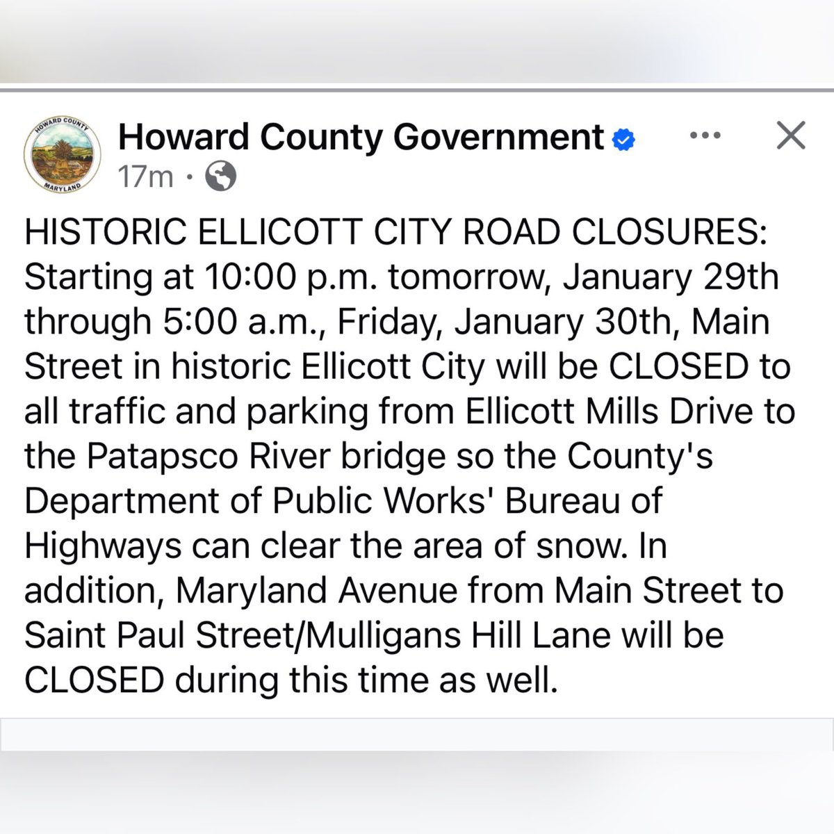
WEATHER UPDATE: @NWS_BaltWash's WINTER STORM WARNING for #HoCoMD remains in effect til 4 am, 1/26.
As of 6:30 a.m., 1/25, @HoCoGov Highways is reporting that at least 3" of snow has fallen across most parts of the county. NWS expects our area to receive ~4-5" of snow; however, this amount includes sleet. NWS's current forecast shows the snow to begin mixing w/ sleet btw 10 am-noon today, and then btw 1-6 pm is when the sleet will begin transitioning to freezing rain. Freezing rain will then fall til 10-11 pm tonight, w/ the most intense period of freezing rain likely btw 7-9 pm. The county is expected to get ~1/10" of ice.