Don't get me wrong, ggplot2 is the very best data visualization tool that exists (at least in my opinion).
However, sometimes you need more flexibility, especially when you want to build highly customized, interactive visualizations for the web.
This is where D3.js and React can be incredibly powerful.
D3.js gives you detailed control over your visualizations, while React helps you build modern, interactive user interfaces. Together, they allow you to create web-based visualizations that go far beyond traditional static charts.
If you want to learn how to use D3.js and React for data visualization, I recommend checking out Yan Holtz's D3 ❤️ React course.
Link to the course: https://t.co/KRXypt338B
Below you can see some of the graphs you'll be able to create after completing the course.
Yan asked me to share this course with my audience, as we've followed each other's work for many years. Even though I wasn't involved in creating the course, I'm confident that the quality will be top-notch, considering the excellent data visualization content Yan has been sharing for so many years.
The course is currently available at an early bird price of €349 instead of €499 until September 6, so you can save €150 if you enroll before then.
Yan was also kind enough to offer me a small affiliate commission if you register through the link above. However, using my link does not make the course any more expensive for you.
#DataVisualization #D3js #ReactJS #DataViz #WebDevelopment #DataScience #RStats #Statistics
Laura Bicker, BBC China correspondent, on the disaster at Gyirong Port on the Nepal–Xizang border: “Shocking footage isn’t being shown in China – and we know little about victims there.”
Numerous people in China have pointed out that the footage is, in fact, all over Chinese platforms; indeed, the very video in the BBC’s own report was released by the Chinese port authorities. So the sequence is: 1) the Chinese state published the clip; 2) the BBC ran the clip; 3) the BBC published a story about how the Chinese state is suppressing the clip.
@AndyBxxx has made another point worth noting: Chinese media doesn’t operate on the basis of “if it bleeds, it leads”. You won’t see grieving relatives and footage of bodies looped for 24 hours. The BBC treats the absence of disaster pornography as evidence of a cover-up rather than a different (and frankly much better) editorial culture.
The article concedes that Beijing has launched “a massive rescue operation involving hundreds of emergency workers”. Even the International Campaign for Tibet, an NED-sponsored Washington-based lobby group, is recorded here “praising the work of first responders”. Xi Jinping personally chaired an emergency meeting to coordinate it. Chinese media has provided “daily updates on the missing and the dead”, plus updates on the rescue operation and on the barrier lake at risk of overflowing. It has shown rescue teams scaling mountains and cliff faces and crossing raging rivers.
Premier Li Qiang was “quickly dispatched to the region” – a level of responsiveness from the top leadership that those of us in the West can only dream of. Compare for example the US response to Hurricane Katrina, or the British government’s response to the Grenfell disaster. From all of that, the article arrives at the phrase “muted response” 🤷🏽
The BBC reports that local CPC members have been asked to step up and help with relief efforts, and provide “emotional guidance or psychological support to affected residents”. This is predictably framed as an operation to “stem any signs of discontent”.
Our intrepid reporter finally reveals her motive with a single clause: “Tibet, which Beijing annexed in the 1950s”. A-ha. It turns out this is a story about British state media, not Chinese state media.
Tibet has been part of China since the 13th century. Taking advantage of the chaos of the collapse of the Qing dynasty, the British invaded Tibet in 1904, at which point they came up with the formula of recognising Chinese “suzerainty” over Tibet while asserting that the region was “independent in internal administration” – which de facto meant that the British could do whatever they wanted there. Incidentally, Britain didn’t abandon that formula until 2008, when it finally recognised China’s sovereignty over the region.
If the BBC is going to insist on a formulation of “Tibet, which Beijing annexed”, it should, for the sake of consistency, also refer to “Cornwall, which London annexed”, since this took place around the same time as Tibet’s absorption into the Yuan Dynasty.
The article goes on to repeat tired tropes about “the Chinese government oppressing and persecuting Tibetans”, albeit without going into the nature of this oppression, which includes raising literacy levels from 5 percent to 98 percent; 15 years’ publicly funded education; the highest per capita central government transfers in China; the elimination of absolute poverty; the provision of modern infrastructure, health care and social services; and impressive efforts to protect and promote Tibetan language and culture.
What doesn’t get a single mention is the cause of the disaster. This was a flash flood in the fastest-warming mountain range on earth, in a region where glacial lakes are multiplying and bursting. There is a genuine story here about climate change coming for the Himalayas and the hundreds of millions who depend on their rivers, but the BBC instead chooses to run with the usual anti-China rubbish.
Solidarity with the people of China and Nepal affected by this disaster, and with everyone working to save them. And shame on a state broadcaster that chooses slander over solidarity.
@BBCWorld Dear BBC News, you say the flood is not covered in Chinese media, but YOUR OWN REPORT is based on footage lifted from Chinese media. (Shakes head sadly)
Everything - and I mean everything - Chellaney is saying is a bald-faced lie.
Which is absolutely disgusting: using such a tragedy - which killed hundreds (if not thousands, we don't know yet) of Nepalis and Chinese alike - to manufacture an entirely fake geopolitical narrative is genuinely beyond the pale.
1) The collapse happened on the Nepal side, not the "Tibetan side": as confirmed by Nepal themselves (https://t.co/hVvGlMNzSP) and as obvious from satellite imagery (https://t.co/B6SRZ6dkOr), Langtang Lirung, where the glacier collapsed, is entirely within Nepalese territory - this is not even a borderline case.
2) There is exactly zero "Chinese hydrological modifications and infrastructure footprint" in this area. You just need to check satellite imagery around the collapse side to check it out: https://t.co/TKvdc0PKgO. It's an extremely wild and unpopulated mountainous area.
The only "infrastructure" there is a border checkpoint, a road, and a bridge that have existed in some form since the 8th century (https://t.co/pkZVW8xPZe). There are no dams. No hydrological modifications. Nothing.
3) On the "no warning" claim: this one is probably the most egregious of all because Chellaney is blaming China for not warning Nepal about something that happened **inside Nepal**.
And, in any case, once the mountain collapse, warnings would unfortunately not have changed people's fates: the mudslide reached the border crossing - just 25km away - within just 7 minutes and 40 seconds (https://t.co/eKzfNAzNn7). There is no conceivable warning system that would have enabled a meaningful evacuation in under eight minutes.
4) If anything, one of the lessons of this terrible tragedy is that you actually WANT more infrastructure footprint in that area, Chinese or otherwise, if only to monitor if nearby mountains or glacier are showing signs of instability.
Entire mountains just don't collapse from one day to the next without showing early signs of weakness that the right sensors could pick up days or weeks in advance.
So the right answer to save lives in the region in the future, which I strongly suspect Chellaney doesn't give the slightest damn about, is more Chinese-Nepali cooperation on joint monitoring infrastructure.
This is unfortunately not Chellaney's first rodeo with anti-China narratives designed to sow division and hatred between developing countries.
He is the man, for instance, who infamously coined the "debt-trap diplomacy" narrative (since thoroughly debunked - see https://t.co/y1EaERG0R5 - but still widely believed) to poison developing countries' relationships with China and thereby deprive them of infrastructure investment they badly need.
How many roads, ports, and railways were delayed or canceled across Africa and Asia because governments were scared off by a narrative that turned out to be false?
It's exactly the same pattern here: a catchy lie designed to sow division and hatred between countries at the exact moment they need each other most.
I hate to say this but, behind all this, there is also a wider India angle. Anyone who's followed posts on X about this tragedy know that the overwhelming share of the disinformation about it - all aimed at weaponizing the tragedy to blame China - has come from thousands of Indian accounts like Chellaney's.
And, given how aggressively India censors social media (shutting down up to thousands of X accounts a week: https://t.co/Se02KGlAYX), the tolerance about this anti-China misinformation campaign unfortunately speaks for itself.
All the more, in this instance, since Chellaney is deeply connected in the Indian government and was a member of India's National Security Advisory Board (https://t.co/DbRh142dNx).
At the risk of stating the obvious, it's pretty pathetic and deeply short-sighted.
This is the case for this specific strategy: every glacier that threatens Nepal threatens northern India just as much: the next collapse could just as easily send a wall of mud into Uttarakhand. And if it does, India will need exactly the kind of cross-border China-Nepal monitoring cooperation that narratives like Chellaney's are designed to destroy.
And it is the case more broadly too: when your strategy consists of turning your neighbors against each other based on lies, sooner or later they realize that the one thing they actually have in common is being deceived by you - and that makes you, not China, the common threat.
This is insane footage of the massive mudslide at the Nepal-China border earlier today: the mudslide, originating from Nepal, seems to have basically completely obliterated the border port in Gyirong (吉隆), Shigatse City, Tibet/Xizang.
We're likely looking at one of the worst mudslides in China's history, really bad tragedy.
For having myself lived in Nepal during several months (in the middle of the devastating 2015 earthquake!), probably the place in the world where nature is the scariest.
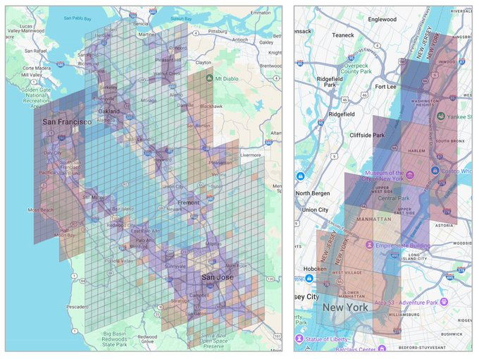
Google trained an AI to predict your neighbourhood's income by counting the coffee shops, bus stops, and high-rises on a map. Nobody told it what income was.
The model is called S2Vec, and it was published by Google Research as part of their Earth AI initiative. It takes the built environment (every building, road, park, and business in an area) and converts it into a layered image. Three coffee shops and one park in a grid cell become pixel values. The AI then reads that image the same way a computer vision model reads a photograph.
The training method is the part that matters. S2Vec uses masked autoencoding: you show the model a patch of a city with chunks missing, and it learns to fill in the gaps. Show it a cluster of high-rise apartments next to a subway station, mask out a section, and it predicts a grocery store belongs there.
Do that millions of times across the globe and the model learns the deep spatial grammar of how cities organise themselves. No human ever labels a region as "financial district" or "suburban residential." The model figures out those groupings on its own from the geometry of what's built where.
The output is an embedding, a string of numbers that acts as a mathematical fingerprint for any location on Earth. Feed those embeddings into a prediction task and S2Vec can estimate population density, median income, and carbon emissions for regions it has never seen before.
On zero-shot geographic extrapolation (predicting for regions entirely absent from training data) S2Vec was typically the best-performing individual model.
It matched or beat satellite imagery baselines like RS-MaMMUT and outperformed GEOCLIP on socioeconomic prediction. The best results came from combining S2Vec with satellite image embeddings. Built environment data alone couldn't capture vegetation, terrain, or transportation patterns well enough for environmental tasks like tree cover and elevation. But fused together, the two modalities outperformed everything else.
The standard approach to geospatial ML has been hand-crafting indicators for every new problem. Predicting air quality meant building a bespoke feature set. Estimating housing prices meant building another one. S2Vec replaces that with a single general-purpose representation that transfers across tasks.
The training data is map features, not satellite pixels.
That distinction is pretty important to understand. It means: map data updates faster, costs less to process, and covers built infrastructure at a resolution satellite imagery can't always match.
A satellite sees rooftops. S2Vec knows there are three cafes, a pharmacy, and a bus stop underneath them.
Google's broader Earth AI pipeline now has three foundation models working in parallel.
1. PDFM for population dynamics.
2. RS-MaMMUT for satellite imagery.
3. S2Vec for the built environment.
Stack them and you get a system that can read a neighbourhood the way a local understands it.
More info on it here: https://t.co/vVJlLlfhc7
Since announcing Jalapeño, our first custom inference chip, we’ve been testing it and the system around it.
The results show a major advance: more intelligence from every watt and faster responses, delivering both higher throughput and lower latency in one architecture without sacrificing efficiency.