22 Ekim 2026 🌍
Manyetosfer 🛡
Manyetik Alan Değişimleri
Dünya Kutup Bölgesi Çizgileri
Gezegenler Arası Manyetik Alan Çizgileri
ISWA | BATSRUS
#magnetosphere#poleshift
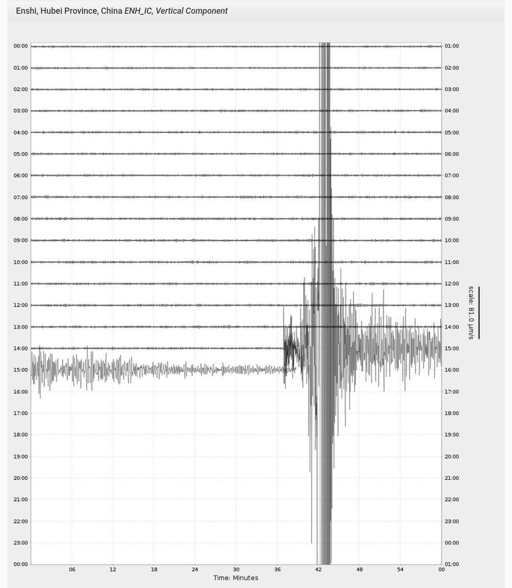
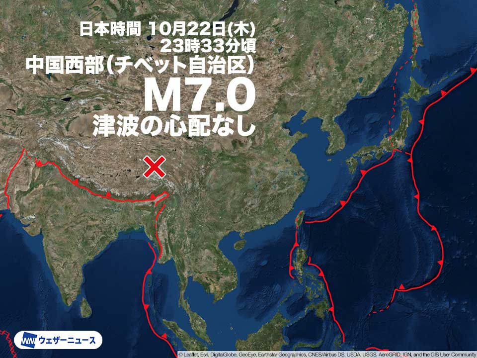
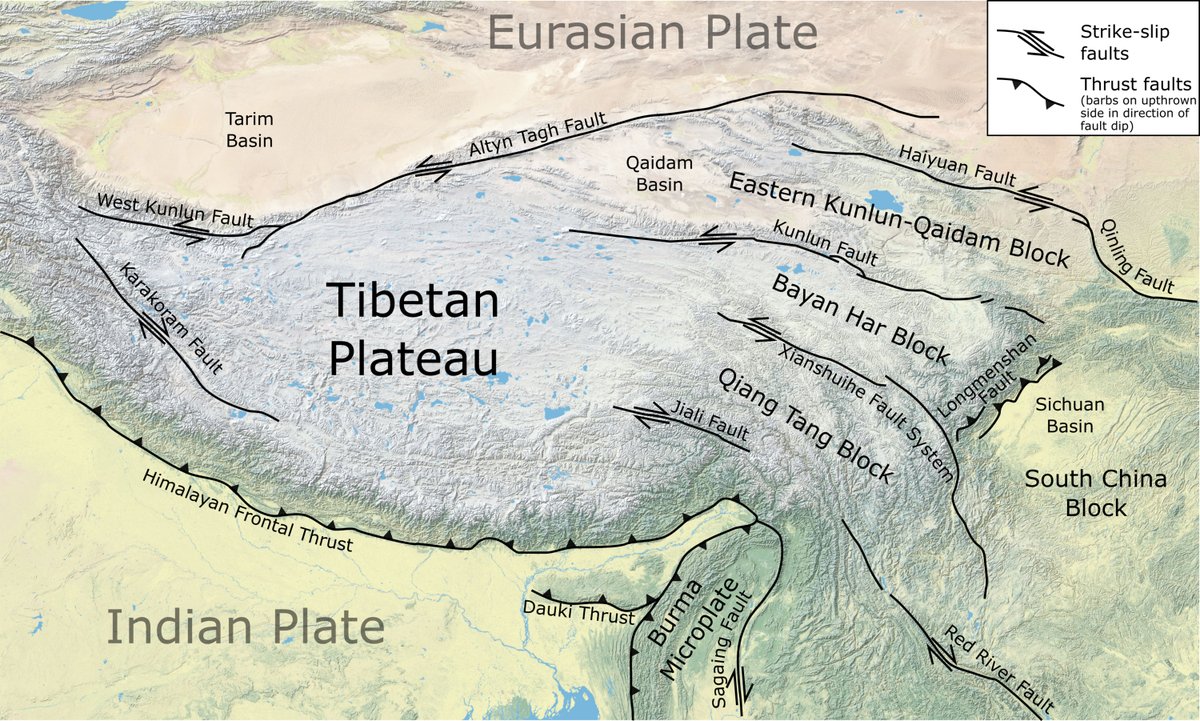
BREAKING: A magnitude-7.0 earthquake struck Baqen County, Nagqu City in Xizang, China, at 22:33 Beijing Time on Thursday, at a depth of 10 km. No confirmed casualties or damage yet. The initial reading of 6.7 was revised upward by CENC.
MAJOR FLOODING: New video coming in from Hurricane, Utah shows just how intense the flooding has become this morning! Gould’s Wash has been running wild this morning, FOR A SECOND TIME THIS SEASON!
Major flash flooding is hitting parts of NSW and Queensland, as severe weather moves through eastern Australia.
Footage from the Upper Orara region, west of Coffs Harbour, shows a truck fully engulfed by the fast-moving water after a sudden creek rise. The driver escaped unharmed.
🌋 Taal Volcano Erupts, Sending Plume 1,200 Metres Into The Sky 🌋
📍 Batangas, Philippines | 22 October 2026
Taal Volcano erupted at 4:52 am local time, producing a 1,200-metre plume above its main crater during a minor phreatomagmatic eruption.
Two remarkable camera recordings capture the eruption from different angles, including thermal footage from Daang Kastila (VTDK) and footage from Lower Calauit (VTLC).
Alert Level 1 remains in effect.
🎥 Footage courtesy of PHIVOLCS-DOST.
#TaalVolcano #Philippines #Volcano #VolcanicEruption #PHIVOLCS
VANCE COULD TRIPLE IN STRENGTH AS MAJOR HURRICANE THREAT BUILDS
A powerful transformation could be unfolding in the eastern Pacific as Tropical Storm Vance strengthens south of Mexico.
With sustained winds currently near 40 mph, Vance is forecast to intensify rapidly, potentially reaching 120 mph and becoming a major hurricane within days.
That’s a possible TRIPLING of wind speed as the storm grows over the Pacific, with dangerous swells potentially reaching Mexico’s coastline!
👉Anyone along Mexico’s Pacific coast noticing changes in ocean conditions? Drop your location and share what you’re seeing.
#MrMBB333 #Vance #hurricaneseason
Whakaari/White Island, Bay of Plenty, New Zealand, 22 October 2026
Whakaari/White Island has moved from occasional ash emissions to a continuous, weak eruption, and GeoNet raised the Volcanic Alert Level from 2 to 3 on 21 October, with the Aviation Colour Code going from Yellow to Orange. An observation flight on 20 October found the vent steadily discharging steam, gas and small amounts of ash, and no sign of an explosive eruption.
Weak ash plumes first showed on webcams on 16 October, after a week of strong steam and gas emissions, and scientists at the time thought the steam was picking up ash as it eroded the walls of the vent, a process seen in March. By 20 October a blanket of ash surrounded the vent in the Main Crater, with a thin layer across the crater floor and parts of the island. Thermal imaging put the temperature of the gas leaving the vent at about 395°C, up from about 100°C within a week, and satellites now detect sulphur dioxide from the volcano every day. The vent itself had not changed in size or shape since 12 October.
Level 3 is GeoNet's minor eruption level, and it was raised because a steady discharge of ash now counts as an eruption, even a weak one. The difficulty is how little can be seen from outside. There are no working instruments on the island, so GeoNet relies on observations from the mainland, satellite data and occasional flights, and it warns that activity could escalate with little or no warning. A sudden explosion could throw rocks across the Main Crater floor and send ash and gas surges across it and out over the sea immediately to the south-east. The 2019 eruption showed what a sudden explosion here can do: at 2:11 pm on 9 December, with the alert level at 2, it killed 22 people, most of them visitors on the island.
Scientists say that episodes over the past 30 years suggest the present activity could continue for weeks. GeoNet sees no threat to the mainland, about 48 kilometres away, beyond a possible smell of sulphur and some light ash when the wind blows onshore.
https://t.co/MyzsCdrNkP
Note: This infographic poster is for reference only and must not be used as factual information, as AI-generated graphics can contain errors.
Vulcaniya | Volcanoes • People • Planet
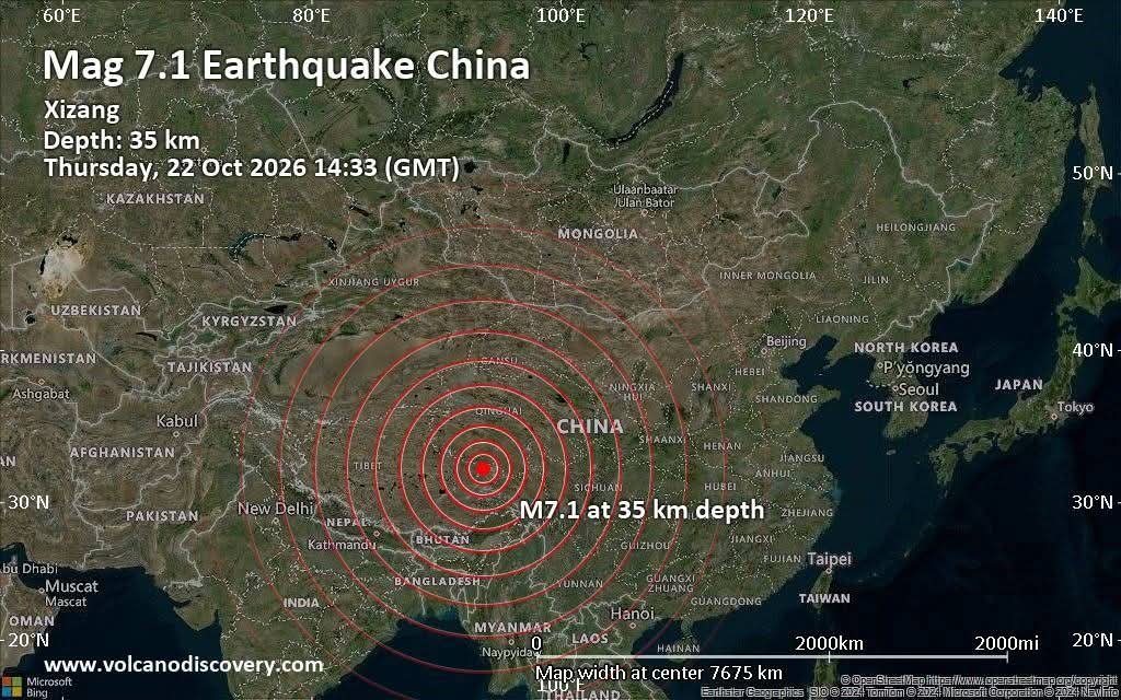
22 Ekim 2026 Xizang Çin 🇨🇳
M 7.1 Deprem ⚡️
Derinlik 10 km
Merkez üssü: 93,89° D, 32,41° K
Tahmini Açığa Çıkan Sismik Enerji:
2 x 10¹⁵ jul (554 gigavat-saat
4,8 x 10⁵ ton TNT
29,8 adet Atom Bombasına Eşdeğer
#earthquake#poleshift
Three people were rescued from raging floodwaters in Los Angeles’ San Fernando Valley Thursday morning, including a man dramatically hoisted to safety by helicopter, while a fourth person managed to escape the swollen channel before firefighters arrived. https://t.co/elJdyu92wm
¡Situación angustiosa! Hoy he recibido este vídeo de una de las 13 personas que fueron rescatadas en la noche del pasado lunes (19/10/2026) en los túneles de la AP-7 a su paso por #PilarDeLaHoradada (#Alicante) tras anegarse por la #lluvia. Tremendo, recuerdo imborrable, ¡ánimo!
📰 #ReporteSASSLA | 🌐 #SismoInternacional
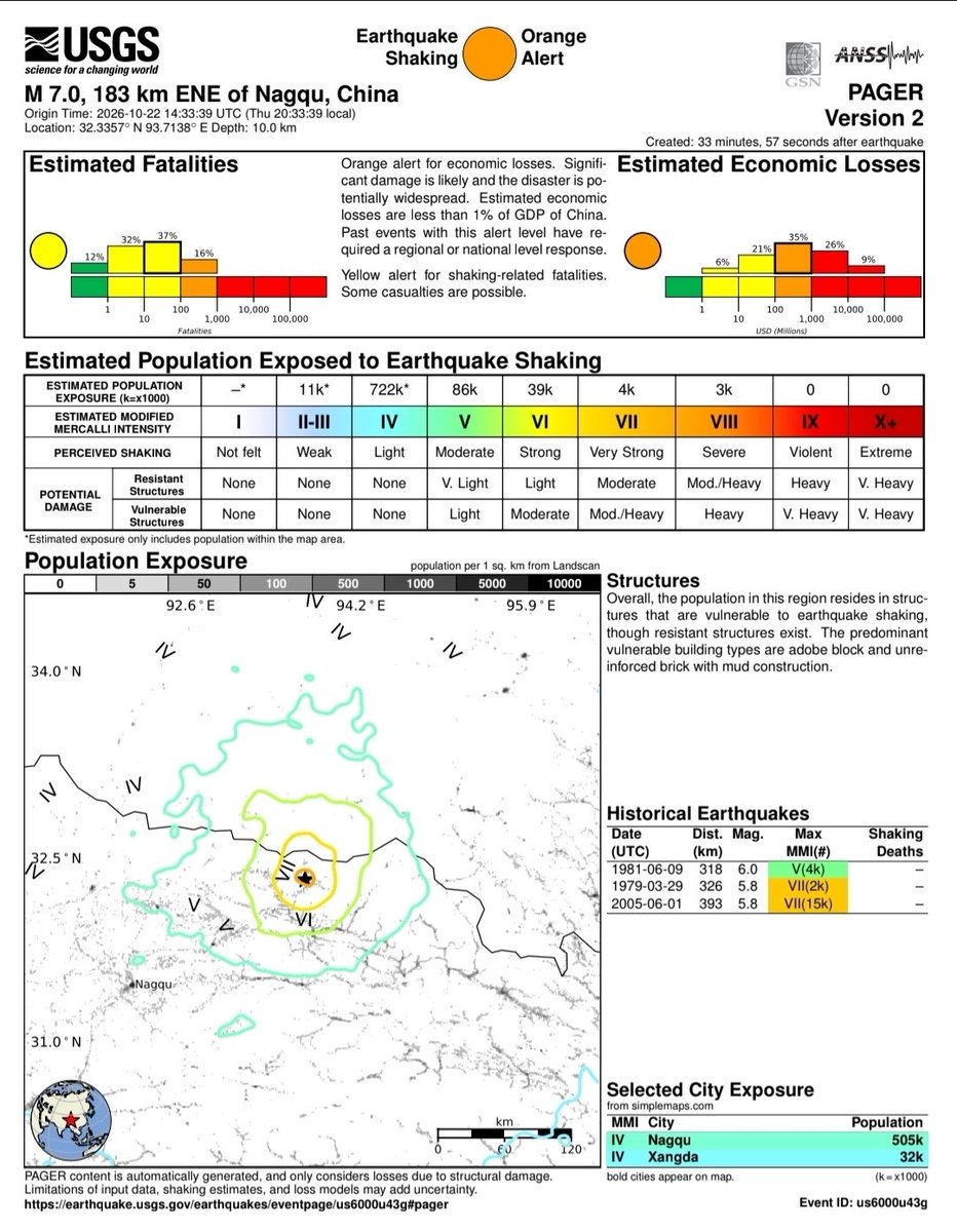
▶ Hoy 22/Oct/2026 a las 14:33 h [hora internacional], se registró un #sismo de magnitud [Mw] 7.0, con epicentro en la región de Baquín, 🇨🇳 #China y a una profundidad de ⏬️ ≈ 18 km.
✅️ Parámetros del evento revisados por el Servicio Geológico de los Estados Unidos [#USGS].
📊 Este es el primer terremoto con magnitud igual o superior a 7.0 en el interior de China continental desde el evento M 7.1 del 07/Ene/2025.
🟠 Debido a la superficialidad del foco, se moldean intensidades máximas de VII - VIII [Severo - escala de Mercalli] en un radio limitado de la zona epicentral.
⚠️ El último informe de automático PAGER [USGS] establece un 🟡 código amarillo en estimación de víctimas mortales (varias a decenas de fallecidos).
❔️ Hasta el momento, las autoridades locales no han confirmado decesos.
Debido a la orografía local (forma de relieve) y las altas aceleraciones sísmicas cerca del epicentro, existe la posibilidad adicional de múltiples deslizamientos de tierra.
🦺 El Ministerio de Gestión de Emergencias de China activó una respuesta de emergencia de Nivel II tras el terremoto: “situación de emergencia mayor”.
💥 El fenómeno, de tipo cortical (superficial), se produce por un fallamiento de tipo normal (de gravedad ⬇️) impulsado por tensiones de corteza.
🗺 La meseta del Tíbet está sujeta bajo un esquema de deformación complejo, donde también por su alta elevación, la sección central de la meseta tiende a extenderse lateralmente bajo su propio peso (⬅️➡️extensión gravitacional), como respuesta a la colisión de la placa de India contra la placa Euroasiáica.
ℹ️ USGS
#SASSLA
SOUTH AMERICA ENDLESS RECORD HEAT
Record heat allover the tropics !
HOTTEST OCTOBER NIGHT IN HISTORY
MINIMUMS
29.3 BONAIRE -Caribbean Netherlands
PERU
24.4 Trujillo
22.6 Pisco
18.4 Tacna
CHILE
21.0 Arica October National record broken/Tied for the 21st time in 21 days !
A powerful magnitude 7.0 earthquake struck northern Tibet, China, late Thursday, shaking a remote, mountainous region where communities sit at some of the highest elevations on Earth. https://t.co/cSpodeNB4j
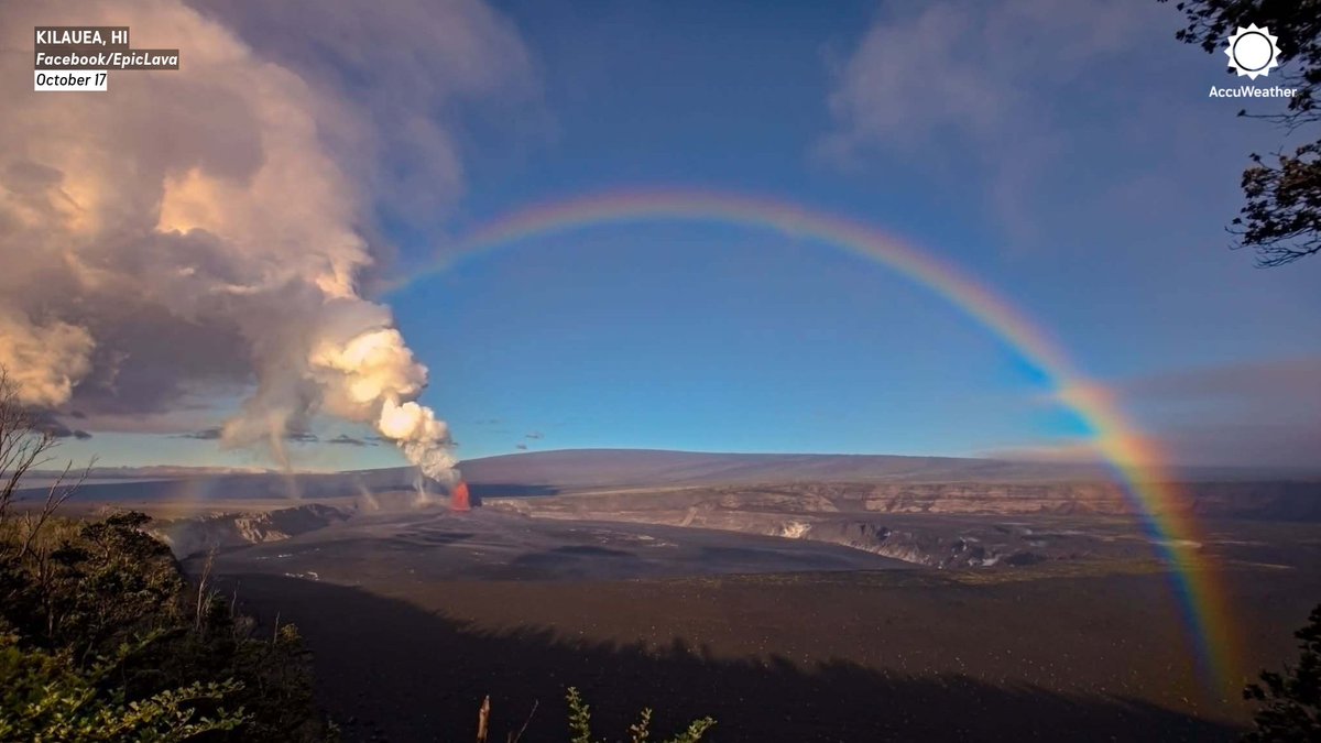
Nature really put on a show! 🌈🌋🌪️ A rainbow stretched over Hawaii's Kilauea volcano as multiple dust devils swirled near the lava during its 55th eruptive episode.