Sentinel-1 interferogram shows ~30 cm of coseismic deformation from #Venezuela's Mw7.2–7.5 #earthquake doublet. #Copernicus#InSAR
The interferogram compares Sentinel-1 acquisitions before (18 June) and after (25 June) the earthquake, revealing the coseismic deformation field with millimetre-scale precision.
The doublet consisted of a Mw7.2 foreshock followed just 39 seconds later by the Mw7.5 mainshock, both at shallow depth, producing severe ground shaking and widespread damage.
The deformation extends from the Caracas region westward toward Puerto Cabello. The largest line-of-sight displacement reaches approximately 30 cm.
The earthquakes ruptured the San Sebastián Fault system, a major strike-slip fault along Venezuela's northern coast and the source of the country's strongest earthquake since 1900.
InSAR complements seismic observations by directly measuring surface displacement, helping scientists constrain fault rupture and improve finite-fault and hazard models.
🏚️#EarthquakeVenezuela#EMSR884
Two 7+ magnitude earthquakes struck #Venezuela affecting thousands of people & causing widespread damage
Our #MappingTeam has been activated to provide damage assessment maps
More information coming soon
🔗 https://t.co/8WJY7Pbm2v
Following yesterday’s powerful back-to-back magnitude 7.2 and 7.5 earthquakes in Venezuela, PDC continues to provide critical updates and information in support of immediate, life-saving response operations as search-and-rescue efforts and damage assessments continue. Widespread damage has been reported, with hundreds of casualties confirmed so far and many more anticipated as the response unfolds.
According to the latest Event Brief an estimated 13.5 Million people (2.81 Million households), 277 hospitals, and over 1,000 schools have been exposed to damaging levels of earthquake shaking. Capital Exposure, representing infrastructure exposed to moderate or higher levels of shaking intensity, is estimated to exceed 550 Billion (USD).
Emergency managers and humanitarian assistance professionals can access critical life-saving data, updates, alerts, and decision-support tools through DisasterAWARE Pro (https://t.co/bYrXC4rNaF)—as highlighted in this post.
The public can access Disaster Alert for free on iOS and Android platforms to stay abreast of these events and receive early warning updates for all hazard types.
#SaferWorld #venezuela #earthquake #disasteraware #EarlyWarningForAll #venezuelaearthquake
@Southcom@cruzrojaveG@ifrc@unocha@wfp
ÚLTIMA HORA | Momentos de pánico se vivió en el aeropuerto de Maiquetía durante el terremoto de 7,5 de magnitud que sacudió a Venezuela este #24Jun https://t.co/R2B1J5AueS
ACTUALIZACIÓN: M 7.5 - 23 km SE de Yumare, Venezuela
2026-06-24 22:05:12 UTC. Profundidad: 10.0 km
Datos de USGS
Mapa: https://t.co/I4nBDTG9hc
#earthquake#sismo
M 7.1 - 28 km NO de Montalbán, Venezuela
- 2026-06-24 22:04:32 UTC. Profundidad: 13.2 km
Datos de USGS.
Mapa: https://t.co/I4nBDTG9hc
#earthquake#sismo
🌋Kīlauea eruption episode 48 summary - a historic new record for Kīlauea!
Episode 48 of the Kīlauea summit eruption in Hawai‘i Volcanoes National Park stopped at 1:37 pm HST June 1 after 9 hours of lava fountaining. This eruption has now surpassed the number of fountaining episodes in the opening years of the Puʻuʻōʻō eruption from 1983-1986 (47), setting a new record number of fountaining episodes in any one Kīlauea eruption.
🌋 Lava flowed from the south vent about 95 times in the days before episode 48, but only the north vent produced a lava fountain (up to 650 ft/200 m) during the episode. This pattern has been followed during the past several episodes. An estimated 7.3 million cubic yards (5.6 million cubic meters) of lava spilled across Halemaʻumaʻu.
💨 The eruptive plume rose to about 24,000 ft (7,300 m) above sea level; higher level winds from the south caused tephra to fall north and east of Kaluapele (Kīlauea caldera) at overlooks within Hawaiʻi Volcanoes National Park, as well as on Highway 11 near Nāmakanipaio Campground, Volcano village, Mauna Loa Estates, and Ohia Estates. The National Weather Service issued an ashfall advisory for these areas downwind.
⛔️ The USGS kept the Kīlauea alert level/aviation color code at WATCH/ORANGE throughout the episode because fallout was not extensive and did not last very long. After the episode ended, USGS lowered Kīlauea to ADVISORY/YELLOW reflecting that volcanic activity had decreased significantly but continues to be closely monitored for possible renewed increase.
Kīlauea summit region inflation since the end of episode 48 indicates that another fountaining episode is possible; however, more time is needed to collect data to generate the model to forecast episode 49, which will set a another new record for Kīlauea.
📹 Video clips show Kīlauea episode 48 lava fountaining on June 1, 2026.
#Kilauea #Lava #Eruption
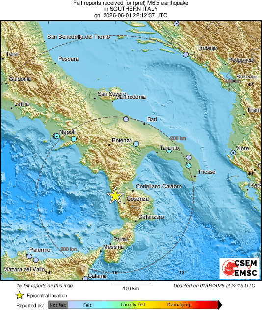
🔴🔴 [DATI #RIVISTI] #terremoto ML 6.2 ore 00:12 IT del 02-06-2026 a Costa Calabra nord-occidentale (Cosenza) Prof= 250.2 Km #INGV_46107472 https://t.co/qFLMUqf0Yw
#Earthquake 25 km NW of Montalto Uffugo (#Italy) 4 min ago (local time 00:12:36). Colored dots represent local shaking & damage level reported by eyeswitnesses. Share your experience via:
📱https://t.co/QMSpuj6Z2H
🌐https://t.co/XM9Yf7xcCT
@Adriana_provida Hola. La fecha y hora es la correspondiente al Tiempo Universal Coordinado (UTC). Para información de eventos sísmicos las agencias sismológicas utilizan este sistema.
La Hora Estándar Central (CST) en Ciudad de México es la UTC - 6:00.