TROPICAL STORM ARTHUR 5 PM UPDATE
Here's the latest track with Tropical Storm Arthur. As it loses it's tropical status it will still bring impacts across the Upstate throughout the day on Thursday.
Tropical Storm Arthur is set to move into the Upstate on Thursday. While it won't be a named storm at that point there will still be widespread impacts from heavy rain, gusty winds, and even an isolated tornado threat.
Round 2 of our severe weather chance is about to begin. Damaging winds are the main concern tonight upwards of 60 mph at times. Here's when to expect the storms in your neighborhood.
More storms are out near Tennessee and will arrive across the Upstate over the next few hours. Main concern will be for more damaging wind gusts and lots of lightning.
Activity should die down around 8/9pm once the front clears.
We're continuing to watch for more storms to develop this afternoon. Gusty winds are the main concern but there's also a good amount of lightning.
We'll continue to bring you the First Alert through the afternoon and evening.
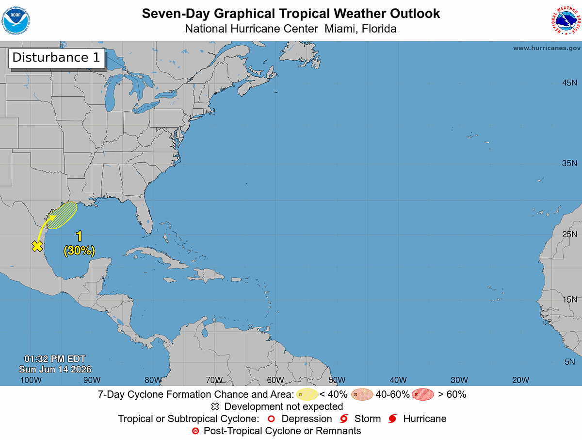
Sun 6/14 2 PM EDT: A trough is producing showers and storms over northeastern Mexico, and no development is expected in the next 24-48 h. However, the system could move into the northwestern Gulf by midweek where conditions may become more favorable for development. Heavy rain and flash flooding are possible across parts of Texas and Louisiana this week. Check out https://t.co/Wq6ZtKfHp9 and https://t.co/zJDnFUKPfU for the latest information.
Heads up for those of you in Hart County & Elbert County Georgia!
The severe warned storm is intensifying with lots of lightning near Lake Hartwell. You want to make sure you're in a safe spot as lightning can strike miles outside of a storm.
SEVERE THUNDERSTORM WARNING in effect until Jun 14 2:15PM EDT for the indicated area. Seek shelter immediately, and get the latest information on the Fox Carolina First Alert Weather App at https://t.co/nRgMiHYI7D.
Heads up for those of you in Greenville & Simpsonville within the next 15 minutes.
Wind gusts upwards of 40 mph if you're downtown and some heavy rain moving in.
Today's a First Alert Weather Day for strong winds with the afternoon storms. They'll be fueled by the heat and humidity we've been dealing with. This will bring some intense downpours and the possibility of wind gusts upwards of 50-60 mph.
Sunday is a First Alert Weather Day as confidence is growing for strong afternoon storms. Damaging winds are the main focus with gusts upwards of 60 mph. Make sure to secure any loose outdoor furniture or trash cans.
Sunday's storms will bring a considerable threat for damaging wind gusts across the Upstate and Northeastern Georgia. The timing coincides with the heating of the day to allow these storms to develop.
We've issued a First Alert Weather Day for Sunday June 14th. The main concern is for damaging winds within the afternoon storms between 2pm-9pm. Wind gusts and microburst from these storms will be possible.
If you're heading to Jazz Fest today it's going to be HOT!!!
Make sure to stay hydrated and wear light colored clothing if you can. Also... a frozen treat isn't a bad idea to help you stay cool!
Heat will be the big story for Saturday. While the heat takes a step back next week thanks to a cold front. Storms also could pose a risk this weekend. Here's the timing of it all.
SEVERE THUNDERSTORM WARNING in effect until Jun 12 9:30PM EDT for the indicated area. Seek shelter immediately, and get the latest information on the Fox Carolina First Alert Weather App at https://t.co/nRgMiHYI7D.
Watching this storm that won't go away crossing into Greenville County.
The storm has a history of producing decent sized hail, heavy rain rates, and wind gusts of 40-60 mph.
We're watching this one closely as it moves into the Upstate.