If you are interested in tornadoes and how terrain can impact them, be sure to check out this new paper. The findings are applicable to the Tennessee Valley and Southern Appalachians. Really enjoyed working with this great team to evaluate this case.
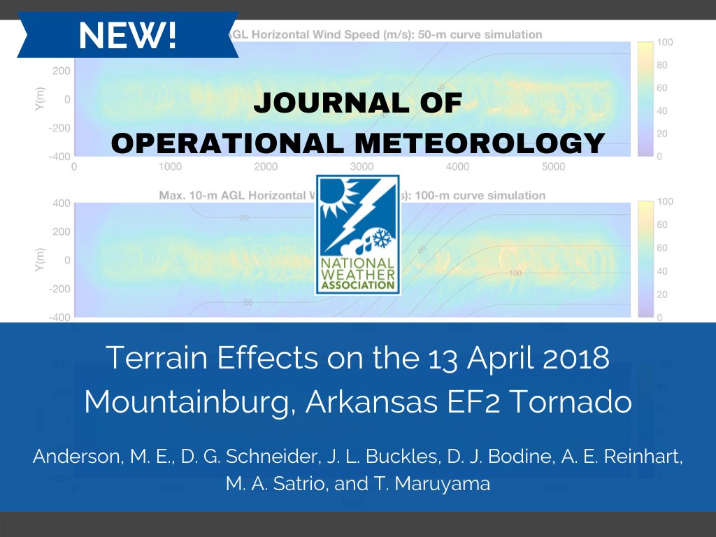
Check out the latest JOM article:
Terrain Effects on the 13 April 2018 Mountainburg, Arkansas EF2 Tornado by Anderson, M. E., D. G. Schneider, J. L. Buckles, D. J. Bodine, A. E. Reinhart, M. A. Satrio, and T. Maruyama
DOI: https://t.co/wjkwbRXBNZ
❄️It's the first snow of the season up on Mt. LeConte at 6593 feet elevation. The LeConte Lodge reached a low temperature of 27°F this morning with a snow measurement of 0.2".
Credit to the LeConte Lodge for the photos!
@NickKrasz_Wx Your estimate would be correct for standard debris based on TDS height research, but an important caveat this time of year is abundant fresh leaf litter that can be lofted by < EF0 tornadoes. The very weak VROT and lack of damage reports would suggest this vortex was sub-severe.
⛈️The risk for a significant severe weather event across the Mid-South and Tennessee Valley continues to increase for Saturday. Damaging winds are the primary risk area-wide, but tornadoes and hail are also possible. Please follow forecast updates closely as we approach Saturday.
A friend and coworker received heartbreaking news the week before Christmas. We are trying to help ease the financial burden. Please read and consider supporting, sharing this with others, and praying for this wonderful and faithful family. https://t.co/ijA7zYVHE1
📉A significant pattern change is expected across much of the country as an Arctic Outbreak is forecast to spread from the Northern Plains to the south and east, leading to exceptionally high probabilities of below-normal temperatures expected across much of the East.🧵
❗️The coldest air of the season to date and dangerous wind chills are likely across many areas of the Southeast. Below freezing temperatures are possible as far south as the Gulf Coast and much of the Florida Peninsula. Impacts to highly sensitive citrus crops are possible.
🚙Frozen precipitation is possible across the parts of the Southern Plains and Southeast with the potential for heavy snow extending northward to include much of Appalachians, Ohio Valley, Mid-Atlantic, Great Lakes, and Northeast, potentially leading to significant travel disruptions.
🥶An Arctic blast of cold air is becoming increasingly likely next week.
Now is the time to prepare. Have a plan to protect pets and livestock by having proper shelter, and ensure pipes and crawl spaces are adequately insulated by winterizing your home or business.
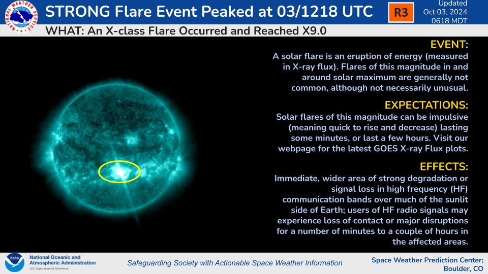
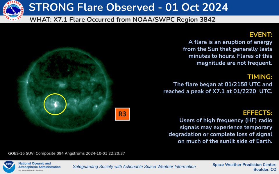
Active Region 3842 produces another (R3 - Strong) solar flare, an X9.0 at 1218 UTC on October 3rd, 2024.
Stay Tuned to https://t.co/YLUbTRM02y for the latest updates!
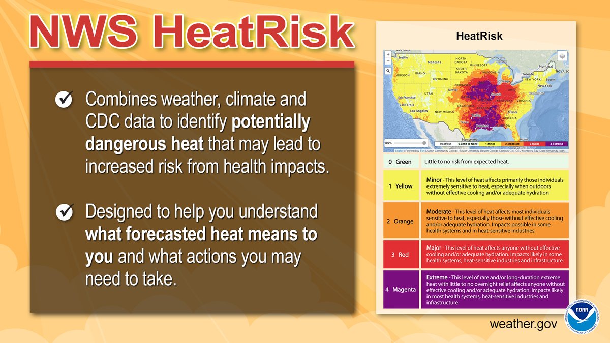
🌡️🔥 Dangerous heat will continue through this weekend in the South-Central U.S. and expand into the East and parts of California next week. If you're planning outdoor July 4th activities, be sure to drink plenty of water and limit time outside during the peak of the heat.
HeatRisk can help people in the U.S. understand what forecasted heat means for them, their families, and their community. Visit the Interactive HeatRisk Viewer: https://t.co/XE9YJY2va0
You can provide feedback at https://t.co/mo4XNgDs0M
#NIHHIS#HeatSafety
📅Mark your calendars!
⚡Saturday, September 28th, 10 AM to 2 PM
Join us for our 2024 Open House! It's free and open to the public!
Look for more details over the upcoming months.
https://t.co/ivFCpQDO69
Clouds have cleared & satellite is giving us a clear view of the remaining snow. It's amazing how tight the gradient was between the areas that received snow and those that only had rain. The areas in white show snow cover. The brown and green areas (vegetation) show no snow.
The morning observation from Mt. LeConte had a current temperature of 15°F with 2" of snow. 🥶
At Newfound Gap, the @GreatSmokyNPS webcam shows snow covering the ground this morning. You can check current Smokies roads info at @SmokiesRoadsNPS. #tnwx#ncwx#mrxwx
Video of the tornado warned storm over Sullivan County, TN last night.
On 11E near Piney Flats looking toward Bluff City and Bristol.
From Lisa Johnson via Chime In.
@natwxdesk