Yesterday 10/15 we broke high temperature records at all 4 of our climate sites. Today, will be close to record high temps again! Today's records:
JAX: 92°F
Alma: 88°F
Gainesville: 94°F
St Simons Island: 88°F
#gawx#flwx
Mid-October sunshine made quick work of yesterday's snowfall. Visible satellite imagery from 8:42 am to 1:47 pm MDT on Monday October 15, 2018. #COwx#KSwx#NEwx
GFS update remains off the charts with forecast rainfall across North Carolina over the next few days. Regional maximum of 42" (5 day total) from #Florence would be about 75% of average annual rainfall.
#GOESEast satellite imagery is one of our most powerful tools to monitor the progress of #Florence this AM https://t.co/dsEI6dyetQ (longer loops via clock + button). Long loops show strong thunderstorms concentrated around the core, with expansive outflow racing off to the north.
More than 1 million people face mandatory evacuation orders as Hurricane Florence -- already packing winds of up to 140 mph -- approaches the US https://t.co/UUw90lptVq
Here is the latest graphic showing the expected path and timing of #HurricaneLane over the next few days from the Central Pacific Hurricane Center. @NHC_Pacific
A rare and sobering sight tonight in the Central Pacific, as Hurricane #Lane becomes only the 6th recorded Category 5 hurricane in this part of the Pacific, and the nearest to #Hawaii a Cat 5 hurricane has ever been observed. #hiwx
Yesterday, Scripps researchers logged the warmest sea-surface temperature at Scripps Pier since records began in August 1916. The record temp—78.6 ℉—is the highest in 102 years of measurements. Data is maintained by the @shoresta100 program at Scripps. https://t.co/JnzGwRIIZW
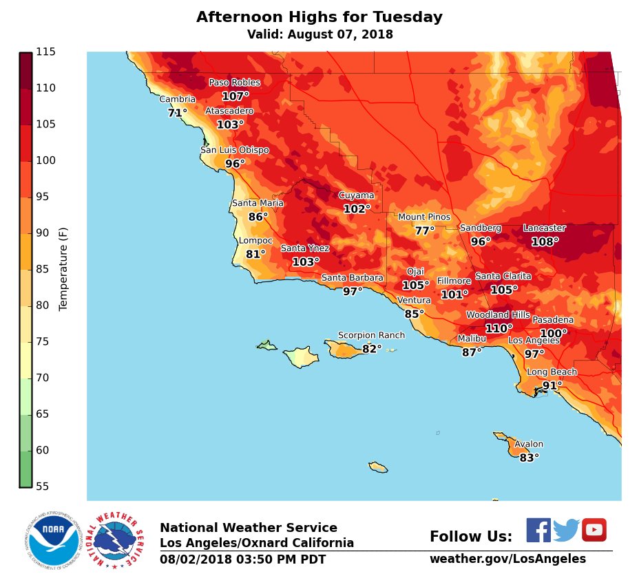
Another long duration heat wave expected for #Socal next week. Peak of heat wave expected on Tuesday with highs between 100-110 degrees across many interior sections. #LAheat#LAWeather#cawx