@BradyBGWX 7 am - 15.3”
9 am - 24.6”
10 am - 27.7”
11 am - 28.8”
12 pm - 30.0”
9 pm - 36.5” (final)
Over a foot in three hours from 7-10 am. Peak rates were around 7-9, especially about 8:30-9; I recorded 2-3” between 8:35 and 8:55 am.
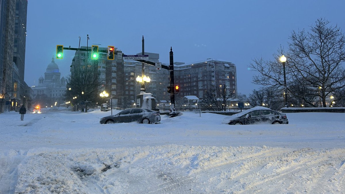
This is College Hill neighborhood of Providence RI.
Thursday night/Friday has certainly gotten more interesting. I’d still lean away from appreciable snow near the city, but the potential is there for a 4/18/20 or 10/30/20 type event of rain changing to snow. These are tricky with marginal temps but can be solid in the right setup
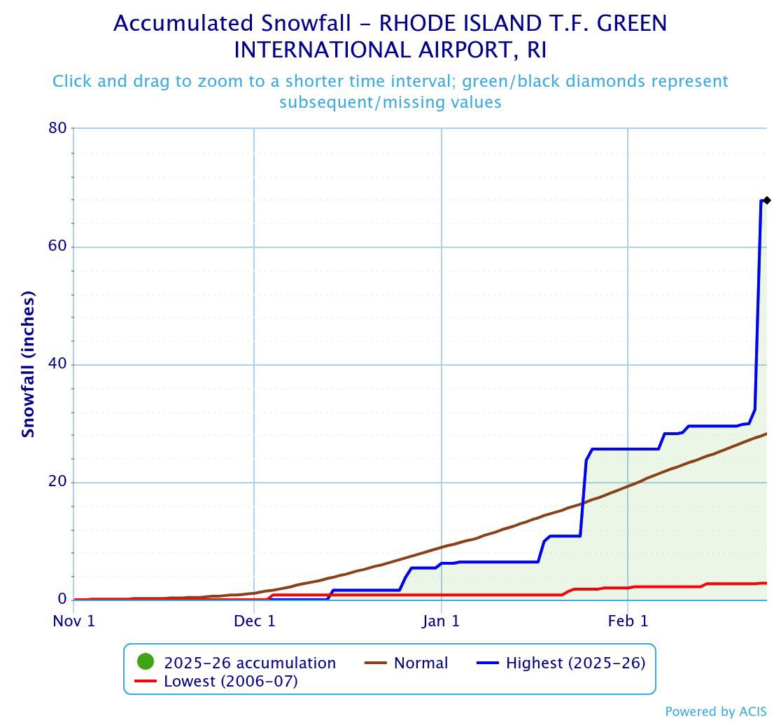
Already in very rare snow depth territory. We're now past a month straight with at least 5" on the ground in Providence (BOS similar but doesn't record snow depth). As of yesterday, snow depth at PVD was 31" (!) which means we have a ways to go, and we could make a run at #2.
@WX1BOX College Hill neighborhood of Providence RI up to 30.0” at 12 pm. Snow has definitely lightened some but still coming down at a good clip. Drifts of 6-8 feet or more.
28.8” at 11 am in College Hill neighborhood of Providence RI — representative measurement of many spots. 4.2” last two hours, 13.5” since 7 am.
Spotter 20-373 @WX1BOX
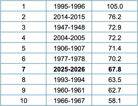
Providence has set their all time monthly snowfall record this February, with 42.2” beating out Jan. 2005. To date, this is the second-snowiest season in history (1996), and for the season the city is already at 7th all time. #1 is untouchable but everything else is in jeopardy.
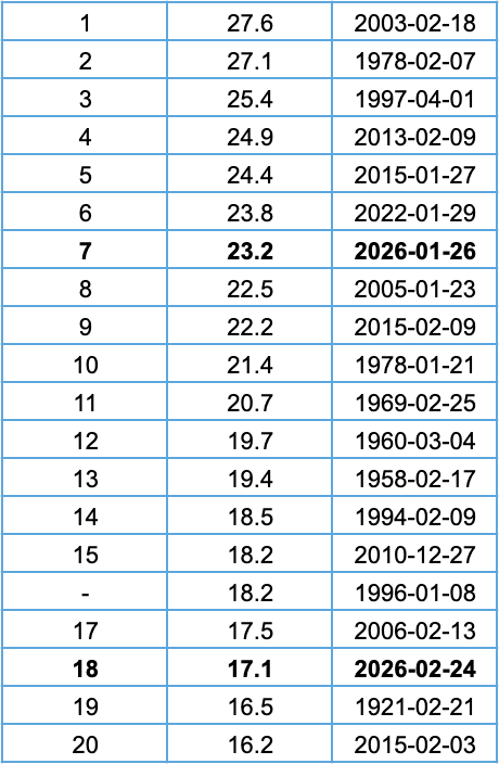
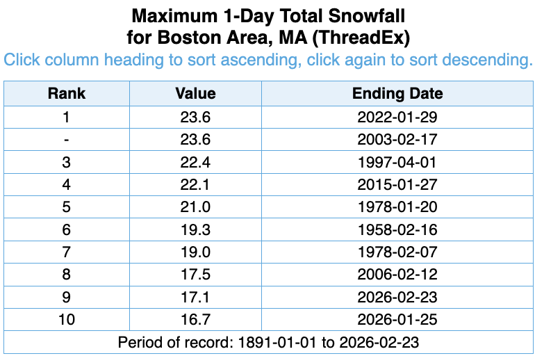
18th biggest storm (2-day total) all time in Boston. 2015 on here 3 times, 1978 on here twice, and this year on here twice. Certainly a historic winter in terms of high-end storms.
While Boston didn't see the same totals as areas to the south, yesterday was still a top-10 day ever for snow. Spots 9 and 10 on this list are from this year. Before this year the only other years with two top-10 snow days were 1978 and 2015 (2/2/15 has since fallen off the list)
This map wasn't perfect, but it seems like it wasn't bad either. Did pretty well with coastal areas, and got the 18-24" and 24-36" zones pretty solidly as well as Pioneer Valley snow shadow. Missed low on RI and Long Island, and missed high for much of PA, upstate NY, and MD.
Here's the forecast for the storm today into tomorrow. Big time snow totals through the coastal Mid Atlantic and southern New England, with wind along all the coasts as well. The widespread nature of this blizzard is something not seen in a decade.
Additionally, the previous 24 hour state record was 30” and the full-storm total was 38”, both in Woonsocket during the Blizzard of ‘78. PVD beat/will beat both records, but other stations may even surpass TF Green’s total. Would not surprise me to see a couple 40”+ reports.
As of the 7 pm report, Providence RI has 37.9” for this storm. In the month before, the airport had 19.1”. That puts us at a 30-day total of 57.0”, which smashes the previous records of 51.2” in 2015 and 50.1” in 1996. May still add a couple inches before this all wraps up too.
Another crazy tidbit about this: 37.9” has set the mark for highest official snowfall EVER recorded on the I-95 corridor! Previous was February 2013 in parts of Connecticut. Or, 36.4” in Milton, MA if you count it.
Again, makes you think about what the theoretical max could be!
As of the 7 pm report, Providence RI has 37.9” for this storm. In the month before, the airport had 19.1”. That puts us at a 30-day total of 57.0”, which smashes the previous records of 51.2” in 2015 and 50.1” in 1996. May still add a couple inches before this all wraps up too.
From NWS offices between Portland ME and Washington, DC, the highest snowstorm total at any major climate station is 36.4” at Blue Hill in Milton, MA in 1969. With Providence at 32.8” as of 1 pm, we could see this storm break the all time east coast snowfall record.
Via NWS:
AS OF 1 PM, THE SNOWFALL TOTAL AT RHODE ISLAND T.F. GREENE
INTERNATIONAL AIRPORT WAS 32.8 INCHES. THIS BROKE THE RECORD FOR THE
GREATEST SINGLE SNOWSTORM ON RECORD, WHICH WAS 28.6 INCHES SET DURING
THE BLIZZARD OF '78, ON FEBRUARY 6-7, 1978.