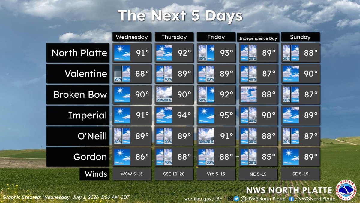
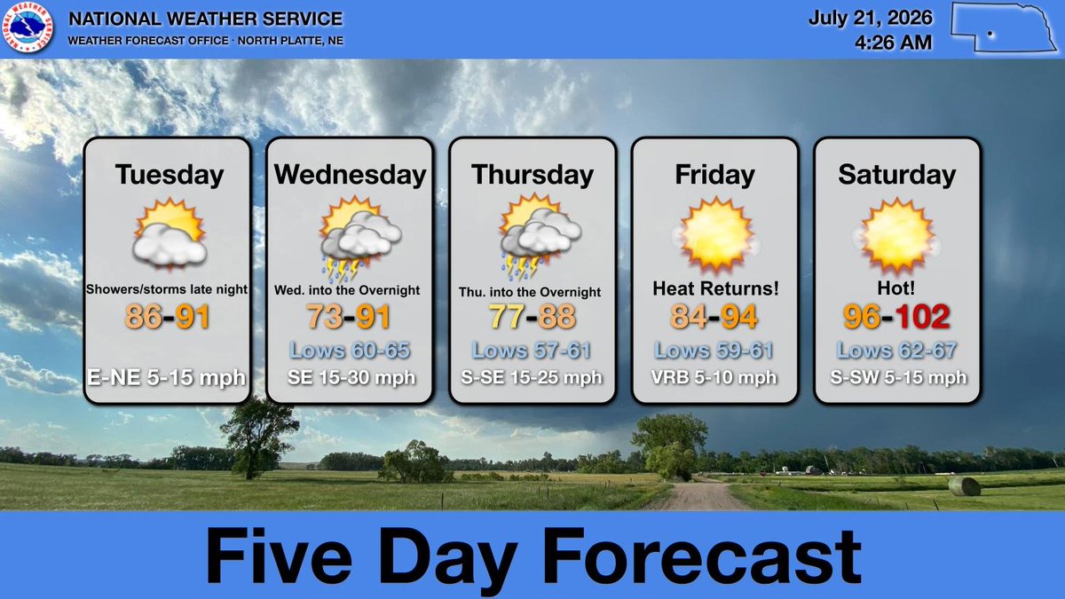
Not as hot today, ranging from 86 to 91. Increasing chances for showers and thunderstorms Tonight through Thu. night. Temperatures will also be cooler across the east. By Fri. highs will warm into the mid 90s in the west and upper 90s to around 100 Sat across western NE. #NEwx
Highs climb into the 90s across the region today, with gusty southerly winds. Stronger wind gusts (30-35 mph) are expected across the Sandhills into the Panhandle. #NEwx
Thunderstorms are expected to develop across western Nebraska by mid to late afternoon and track east through the evening.
Some storms may become severe, with large hail and damaging winds as the main threats. Storms should gradually weaken later tonight. #NEwx
[Valid 7/8/2026]:
Scattered to numerous severe thunderstorms are possible this afternoon through evening. Areas along and south of HWY 2 has the highest likelihood of seeing severe wind gusts of 60+ mph. Secondary threats include large hail and heavy rains. #NEwx
Wednesday (7/8) has a scattered chance of strong to severe thunderstorms possible across western, southwest Nebraska and the Sandhills. The primary threat will be damaging wind gusts with secondary threats of large hail, heavy rain, and frequent lightning. #NEwx
Quiet weather is expected tonight and tomorrow for most of western and north central Nebraska. There is a chance for thunderstorms across northwest Nebraska Monday afternoon and evening, however no severe weather is expected at this time. #NEwx
Scattered severe storms are possible late this evening into tonight! A Slight Risk (Level 2 of 5) is in place for northern NE. The primary threat is damaging winds and large hail between 5 PM this evening and 3 AM Friday. Have multiple ways to receive warnings! #NEwx
Heading into the Independence Day weekend, expect warm temps and daily chances for storms. Highs will be in the upper 80s to mid 90s, peaking on Friday. Keep an eye on the forecast for your outdoor holiday plans! 🎆⛅ #NEwx
Heads up, western and north central Nebraska! Late evening storms could become severe as they move into central NE tonight (9pm-3am). Damaging winds and large hail are the primary threat. Make sure you have multiple ways to receive warnings overnight! #NEwx
Atmospheric smoke (seen as light grey) from forest fires in southern Colorado can be seen on satellite imagery across western and north central NE this morning. #NEwx
A Level 3 of 5 enhanced risk for severe storms exists across portions of the Panhandle and southwest Nebraska this evening. Damaging winds, large hail, heavy rain, and frequent lightning are the primary threats. #NEwx
Scattered severe thunderstorms are possible Saturday afternoon and evening. Large hail and damaging winds are the primary threats. An isolated tornado and heavy rainfall are also possible. Stay weather aware. #NEwx
There is a slight risk for severe thunderstorms Saturday afternoon into the evening hours. Large hail, damaging winds and heavy rain are the main severe threats. An isolated tornado or two cannot be ruled out. #newx
Severe thunderstorms are expected this afternoon into the evening. There is an enhanced risk for parts of the area. Large to very large hail, wind gusts greater than 70 mph and a few tornadoes will all be possible. #newx
Near-critical fire weather concerns are expected this afternoon into early this evening for areas west of Highway 61 from Merriman to Ogallala. This is due to a combination of low humidity and strong, gusty south winds. #newx
Heat will build into western and north central Nebraska over the next several days. Highs will reach well into the 90s for Saturday and Sunday with a slight cooldown to upper 80s on Monday. Highs will then reach back into the 90s for Tuesday. #newx
A TON of instability will be in place tomorrow across the Central Plains and Midwest! 😲
There are two areas I am watching for severe weather. The first, is the obvious one, across parts of Nebraska, Iowa, Missouri, and Kansas, with very large hail, significant damaging winds, and a couple of tornadoes possible between 5pm-1am, as a line of thunderstorms will quickly develop.
The second area is far more conditional across the Midwest (Davenport to Milwaukee to Chicago), where a MCV is possible. If this develops from the remnant storms today, we could see a low-end tornado threat during the afternoon and early evening. Otherwise, isolated damaging wind gusts will be the main concern.
Scattered strong to severe thunderstorms will develop late this afternoon across the panhandle and northern NE and move southeast this evening and overnight. Large hail and damaging winds will be possible this evening, especially across portions of north central NE. #NEwx






![NWSNorthPlatte's tweet photo. [Valid 7/8/2026]:
Scattered to numerous severe thunderstorms are possible this afternoon through evening. Areas along and south of HWY 2 has the highest likelihood of seeing severe wind gusts of 60+ mph. Secondary threats include large hail and heavy rains. #NEwx https://t.co/UddFraEu3t](https://pbs.twimg.com/media/HMt1xpLWIAAPokH.jpg)